Report on Pagan (United States) — December 2010
Bulletin of the Global Volcanism Network, vol. 35, no. 12 (December 2010)
Managing Editor: Richard Wunderman.
Pagan (United States) Quiet with only minor steam emissions in October and November 2010
Please cite this report as:
Global Volcanism Program, 2010. Report on Pagan (United States) (Wunderman, R., ed.). Bulletin of the Global Volcanism Network, 35:12. Smithsonian Institution. https://doi.org/10.5479/si.GVP.BGVN201012-284170
Pagan
United States
18.13°N, 145.8°E; summit elev. 570 m
All times are local (unless otherwise noted)
During 24 and 26-27 October and 1-4 November 2010, low-level gas-and-steam plumes were observed in satellite imagery. On 23 February 2011, the Aviation Color Code for Pagan was downgraded from Yellow to Unassigned, and the Volcano Alert Level from Advisory to Unassigned.
No MODVOLC thermal alert for Pagan has been issued for the last 10 years; however, infrequent thermal anomalies from other systems that have less stringent criteria than MODVOLC have been reported.
As background, following a small eruption in 2006 and in subsequent behavior through September 2010, Pagan has been mostly quiet, with plumes that occasionally contained some ash (BGVN 32:01, 34:09, and 35:07). Pagan is not monitored with ground-based geophysical instrumentation. The only sources of information are satellite observations and occasional reports from observers who pass or visit the island.
General References. Koyanagi, R., Kojima, G., Chong, F., and Chong, R., 1993, Seismic monitoring of earthquakes and volcanoes in the Northern Mariana Islands: 1993 summary report: Prepared for the Office of the Governor, Commonwealth of the Northern Mariana Islands, Capitol Hill, Saipan MP 96950 (revised 21 February 1993), 34 p.
Trusdell, F. A., Moore, R. B., and Sako, M. K., 2006, Preliminary Geologic Map of Mount Pagan Volcano, Pagan Island, Commonwealth of the Northern Mariana Islands, U.S. Geological Survey, Open-File Report 2006-1386 (URL: http://pubs.usgs.gov/of/2006/1386/).
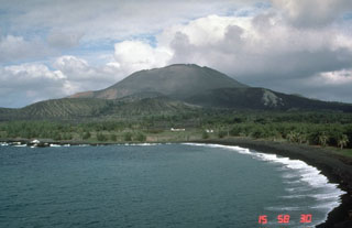
Geological Summary. Pagan Island, the largest and one of the most active of the Mariana Islands volcanoes, consists of two stratovolcanoes connected by a narrow isthmus. Both North and South Pagan stratovolcanoes were constructed within calderas, 7 and 4 km in diameter, respectively. North Pagan at the NE end of the island rises above the flat floor of the northern caldera, which may have formed less than 1,000 years ago. South Pagan is a stratovolcano with an elongated summit containing four distinct craters. Almost all of the recorded eruptions, which date back to the 17th century, have originated from North Pagan. The largest eruption during historical time took place in 1981 and prompted the evacuation of the sparsely populated island.
Information Contacts: Emergency Management Office of the Commonwealth of the Northern Mariana Islands (EMO-CNMI) and USGS Volcano Hazards Program, PO Box 100007, Saipan, MP 96950, USA (URL: http://www.cnmihsem.gov.mp/ and http://volcanoes.usgs.gov/nmi/activity/); Washington Volcanic Ash Advisory Center (VAAC), Satellite Analysis Branch (SAB), NOAA/NESDIS E/SP23, NOAA Science Center Room 401, 5200 Auth Rd, Camp Springs, MD 20746, USA (URL: http://www.ospo.noaa.gov/Products/atmosphere/vaac/); Hawai'i Institute of Geophysics and Planetology (HIGP) Thermal Alerts System, School of Ocean and Earth Science and Technology (SOEST), Univ. of Hawai'i, 2525 Correa Road, Honolulu, HI 96822, USA (URL: http://modis.higp.hawaii.edu/).