Report on Galeras (Colombia) — May 2011

Bulletin of the Global Volcanism Network, vol. 36, no. 5 (May 2011)
Managing Editor: Richard Wunderman.
Edited by Julie A. Herrick.
Galeras (Colombia) Eruption on 25 August 2010; gas emissions in early 2011
Please cite this report as:
Global Volcanism Program, 2011. Report on Galeras (Colombia) (Herrick, J.A., and Wunderman, R., eds.). Bulletin of the Global Volcanism Network, 36:5. Smithsonian Institution. https://doi.org/10.5479/si.GVP.BGVN201105-351080
Galeras
Colombia
1.22°N, 77.37°W; summit elev. 4276 m
All times are local (unless otherwise noted)
Our previous report (BGVN 34:12) covered explosive eruptions at Galeras on 30 September 2009, 20 November 2009, and 2 January 2010 (included in table 11). This report discusses the recent eruption in August 2010 and intense degassing and seismic events between January 2011 and May 2011.
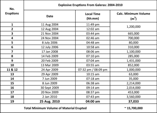 |
Table 11. Minimum volumes of erupted material from Galeras calculated for events from August 2004 to August 2010. Number of eruptions, Date, Local Time (hour and minute), and Calculated Minimum Volume in cubic meters. Adapted from INGEOMINAS (2010a). |
The Instituto Colombiano de Geología y Minería (INGEOMINAS) use an alert scale from I-IV, a Level I being the highest. They declared a Level I alert during an eruption in August 2010 and a Level II during unrest in late January 2011. To date, Level III status has been maintained since 8 February 2011.
Eruption of 25 August 2010. On 20 August 2010, after several days of increased gas emissions, an earthquake swarm began. According to INGEOMINAS, seismicity remained high during 21-22 August. Five volcano-tectonic earthquakes were felt by local residents and caused windows to vibrate. The events were located within a 300-900 m radius of the crater, at depths of less than 2 km. The largest event was M 4.3.
On 23 August a M 4.6 earthquake struck E of Galeras at a depth of 2 km. The Alert Level was raised to II (Orange; "probable eruption in terms of days or weeks"). SO2 emissions peaked at 304 tons/day on 23-24 August (table 12).
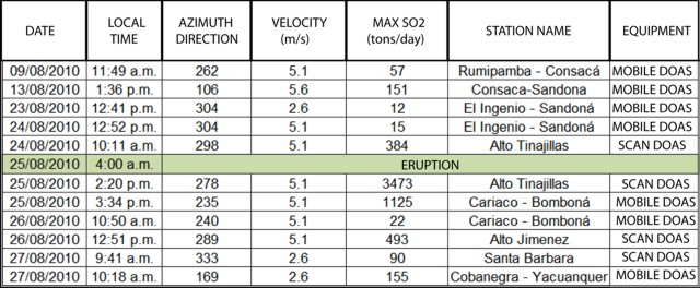 |
Table 12. Emissions of SO2 (metric tons/day) from Galeras during August 2010 measured by ScanDOAS and MovilDOAS (supported by Proyecto NOVAC). Low (under 500); Moderate (500-1,000); High (1,000-3,000); Very High (over 3,000). Courtesy of INGEOMINAS (2010a). |
An eruption began at 0400 on 25 August, prompting INGEOMINAS to raise the Alert Level to I (Red; "imminent eruption or in progress"). Meteorological cloud cover initially prevented visual observations of the summit, although an eruption plume was seen among the clouds and thermal anomalies were detected by an infrared camera. At ~0700, an overflight of the flanks was videorecorded which documented a low-altitude gray plume distinctive from the atmospheric clouds (INGEOMINAS, 2010c). With a thermal camera, the Colombian Air Force documented that hot material fell from the secondary crater, El Paisita (INGEOMINAS, 2010b). Ashfall was reported to the NW, as far away as 30 km and quantified as over 37,033 m3 of material (table 11). Ash was reported in Samaniego, Linares, Ancuya, Sandoná, and Consacá. Observers in Pasto (~ 10 km E) reported that gas-and-ash plumes rose 300 m above the crater.
Seismicity associated with the 25 August eruption continued for a period of about 12 hours and gradually declined in the afternoon. INGEOMINAS lowered the Alert Level to II. According to news articles, at least 7,000 residents were ordered by government officials to evacuate, although few left their homes. During 26-31 August, at least 12 earthquakes, M 2-4, struck within a 2 km radius from the crater, at depths not more than 3 km. Gas plumes drifted NW, then S.
Seismic and thermal activity in 2011 through May. Overflights conducted by INGEOMINAS on 7 January 2011 collected multiple infrared and visible photopairs, one set of which appears as figure 113. The maximum temperature of the central crater reached 287.2°C. Temperatures of the rim and flank fumaroles were also recorded. A calculation was made for an area of three fumaroles close to the rim yielding a maximum temperature of 31.2°C.
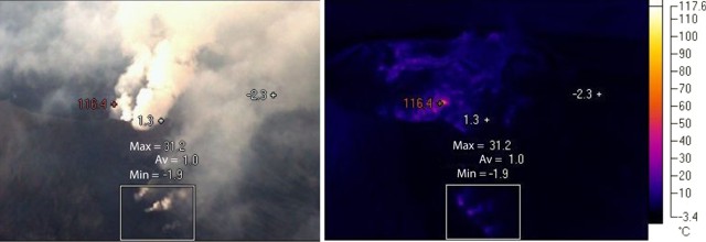 |
Figure 113. A set of visible (left) and infrared (right) photo of both the crater and some flank fumaroles at Galeras taken during an INGEOMINAS overflight on 7 January 2011. The flank location is not disclosed. Taken from INGEOMINAS (2011b). |
According to INGEOMINAS, on 25 January an emerging seismic pattern from Galeras, characterized by "tornillo-type" earthquakes, was similar to patterns detected before past eruptions. Tornillos are "monochromatic [narrow range of frequencies] long-period seismic events of a few minutes duration with long codas of constantly decreasing amplitude" (Morrissey and Mastin, 2000). The waveform of a tornillo is illustrated and described in more depth in BGVN27:05. The staff noted a strong sulfur gas odor and observed emissions that drifted N from various areas of the crater. Based on changes in seismicity and observed gas emissions, INGEOMINAS raised the Alert Level to II.
On 27 January 2011, scientists again observed emissions from various areas of the crater during an overflight (figure 114) and there was a slight increase in the number of vents. Gas plumes drifted NW and thermal imagery showed clearly-defined fumaroles. Imagery measured the maximum temperature of the central vent around 300°C (reported as 294.7°C).
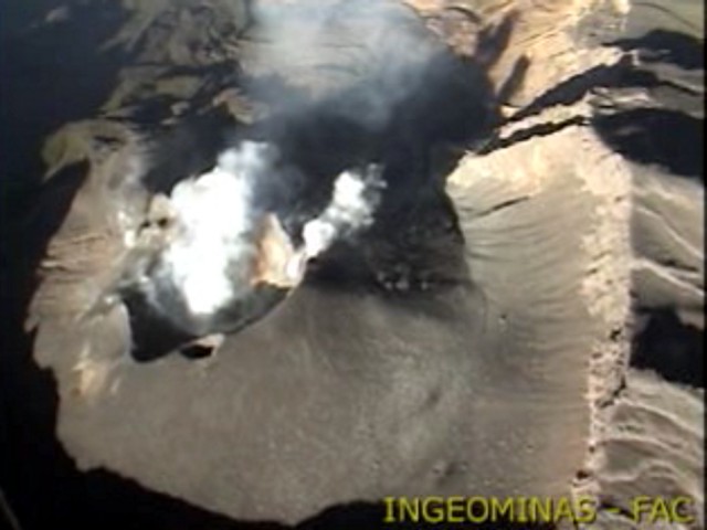 |
Figure 114. A stillshot from video footage of degassing at Galeras taken during an INGEOMINAS overflight on 27 January 2011. Gas from the crater and fumaroles was blown in a diffuse plume moving approximately W. Look direction is W. Taken from INGEOMINAS (2011b). |
On the morning of 30 January, tornillos ceased.
In early February 2011, seismic levels continued to fluctuate. On 6 February an overflight revealed that gas emissions had increased in comparison to the previous week, forming plumes that drifted NW; however INGEOMINAS lowered the Alert Level to III.
INGEOMINAS reported gas-and-steam emissions on 31 March and 1 April with low ash content. On 1 April, a M 2.3 earthquake occurred 3 km E of the crater at a depth of 6 km and was felt by nearby residents. During an overflight on 2 April, scientists noted a sulfur gas odor and observed that gas emissions rose from multiple areas of the active cone. During 30 March-5 April, SO2 gas values were between 50 and 2,000 tons per day, the latter value considered high for Galeras.
As of 7 April 2011 there was a decrease in transient seismic signals. Within the first week of the month there were three tornillo events with oscillations around 7.5 Hz. After 7 April tornillos were no longer recorded and seismicity was dominated by an increase of events interpreted as the result of fluid motion within the volcanic system and gas emissions. The April 2011 INGEOMINAS monthly report concluded that hypocenters of earthquakes clustered in three distinct zones (figure 115).
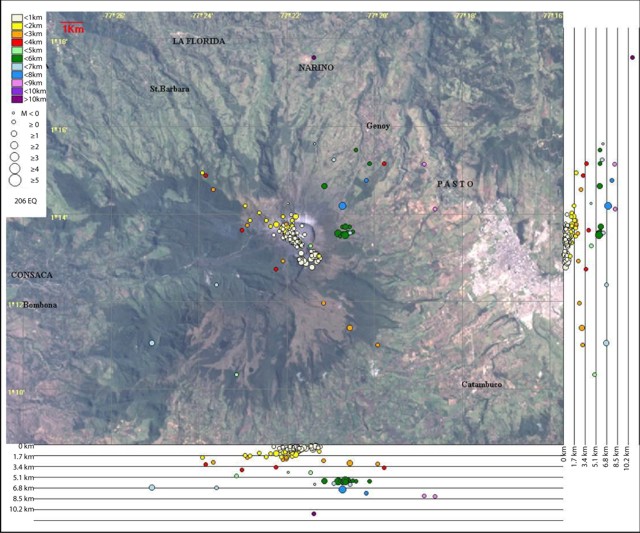 |
Figure 115. A map and cross sections plotting 206 epicenters and hypocenters of volcano-tectonic and hybrid earthquakes that occurred during 1-30 April 2011 at Galeras. In the N-S section (right) and the E-W section (bottom), each line represents 1.7 km of depth with respect to the summit (elevation, ~4,200 m). Magnitudes of seismic events are indicated by circle size. Colors indicate depths, which ranged from under 1 km to over 10 km. Courtesy of INGEOMINAS (2011c). |
One zone was a shallow (under1 km) area focused on the crater in the SE sector. A second source was located to the W of the crater with depths up to 2.5 km (with respect to the summit) and a deeper source was identified between 5 and 7.5 km to the E of the crater. The most distant events (up to 8 km) were dispersed with depths around 11 km. The largest of these, M 2.4, occurred at 0454 on 1 April.
Between 13 April-17 May 2011, steam rose up to 1.2 km in altitude and the values of SO2 ranged from low to high with emission values reaching up to 1,600 tons per day. Residents in the city of San Juan de Pasto, just to the E, reported the foul odor of sulfur gases, mainly H2S. On 18 April, an onsite INGEOMINAS team noted a strong odor of sulfur gases and emission from both the main crater and secondary craters and fumarolic fields. That same day a M 1.9 earthquake occurred 6 km SW of Galeras at a depth of ~7 km.
According to INGEOMINAS, favorable weather conditions during 11, 15-10, and 22 May allowed observers to note plumes with heights up to 700 m. On 15-16 May, heavy rains produced lahars that swept down Galeras'slopes carrying rocks, soil, and plant material into and down drainages.
With support from the Colombian Air Force, overflights of Galeras were conducted on 18, 20 and 22 May. Various rates of gas emissions were observed, mostly from vents, secondary craters, and cracks on the slopes of the active cone. Thermal anomalies were detected in various areas, with an average value of 170°C at the bottom of the main crater and 205°C in the secondary crater "The Paisita" N of the active cone.
References. INGEOMINAS, Instituto Colombiano de Geología y Minería, 2010a, Pasto Observatory Work Group: Monthly Report on Galeras and the Volcanoes of Doña Juana, Cumbal, and Azufral, August 2010 (URL: http://intranet.ingeominas.gov.co/pasto/images/1/1e/Boletin_mensual_de_actividad_de_los_volcanes_del_sur_agosto_2010.pdf).
INGEOMINAS, Instituto Colombiano de Geología y Minería, 2010b, Review of Activity from Galeras 24 Aug.-30 Aug., 2010, (URL: http://intranet.ingeominas.gov.co/pasto/Imagen:Resumen_actividad_galeras_ago_24_ago_30_2010.pdf).
INGEOMINAS, Instituto Colombiano de Geología y Minería, 2010c, Sobrevuelo volcán Galeras 8/25/2010, (URL: http://intranet.ingeominas.gov.co/pasto/Videos_2010).
INGEOMINAS, Instituto Colombiano de Geología y Minería, 2011a, Thermal Images 2011, 1/7/2011,
(URL: http://intranet.ingeominas.gov.co/pasto/Imágenes_térmicas_2011).
INGEOMINAS, Instituto Colombiano de Geología y Minería, 2011b, Sobrevuelo volcán Galeras 1/27/2011, (URL: http://intranet.ingeominas.gov.co/pasto/Videos_2011).
INGEOMINAS, Instituto Colombiano de Geología y Minería, 2011c, Pasto Observatory Work Group: Monthly Report on Galeras and the Volcanoes of Doña Juana, Cumbal, and Azufral, April 2011 (URL: http://intranet.ingeominas.gov.co/pasto/images/8/8b/Boletin_mensual_de_actividad_de_los_volcanes_del_sur_abril_2011.pdf).
Morrissey, M.M., and Mastin, L.G., 2000, Vulcanian Eruptions, in Sigurdsson, H., ed., Encyclopedia of Volcanoes: San Diego, California, Academic Press, p. 463-475.
Geological Summary. Galeras, a stratovolcano with a large breached caldera located immediately west of the city of Pasto, is one of Colombia's most frequently active volcanoes. The dominantly andesitic complex has been active for more than 1 million years, and two major caldera collapse eruptions took place during the late Pleistocene. Long-term extensive hydrothermal alteration has contributed to large-scale edifice collapse on at least three occasions, producing debris avalanches that swept to the west and left a large open caldera inside which the modern cone has been constructed. Major explosive eruptions since the mid-Holocene have produced widespread tephra deposits and pyroclastic flows that swept all but the southern flanks. A central cone slightly lower than the caldera rim has been the site of numerous small-to-moderate eruptions since the time of the Spanish conquistadors.
Information Contacts: Instituto Colombiano de Geología y Minería (INGEOMINAS), Observatorio Vulcanológico y Sismológico de Popayán, Popayán, Colombia.