Report on Tongariro (New Zealand) — July 2012
Bulletin of the Global Volcanism Network, vol. 37, no. 7 (July 2012)
Managing Editor: Richard Wunderman.
Edited by Robert Dennen.
Tongariro (New Zealand) Seismicity preceded phreatic explosion; associated rainfall-fed lahar
Please cite this report as:
Global Volcanism Program, 2012. Report on Tongariro (New Zealand) (Dennen, R., and Wunderman, R., eds.). Bulletin of the Global Volcanism Network, 37:7. Smithsonian Institution. https://doi.org/10.5479/si.GVP.BGVN201207-241080
Tongariro
New Zealand
39.157°S, 175.632°E; summit elev. 1978 m
All times are local (unless otherwise noted)
Elevated seismicity in July 2012 preceded a phreatic eruption at Tongariro on 6 August. The eruption ejected blocks of old lava from the crater area, and triggered a debris flow down a drainage on a flank of the volcano. Six days later, heavy rainfall remobilized some of the debris flow and generated a small flood/lahar that crossed a state highway. This report summarizes GeoNet alert bulletins and Taupo Civil Defense postings concerning the phreatic explosion and associated events (through 17 August 2012).
Precursory seismicity. GeoNet reported elevated numbers of volcanic earthquakes (M < 2.5) beginning on 13 July (figure 2). Seismicity then declined until 18 July, when volcanic earthquakes returned, increasing in magnitude and abundance through 20 July. The earthquakes were clustered between Emerald Lake and the SE shore of Lake Rotoaira at 2-7 km depth; a subset of the earthquakes were tightly clustered between Blue Lake and Te Maari (Te Mari) Craters within the same depth range (figures 2 and 3). As a result, the Volcano Alert Level was raised from 0 to 1 (on a scale from 0-5) and the Avation Colour Code was raised from Green to Yellow (on a four color scale; Green-Yellow-Orange-Red) on 20 July.
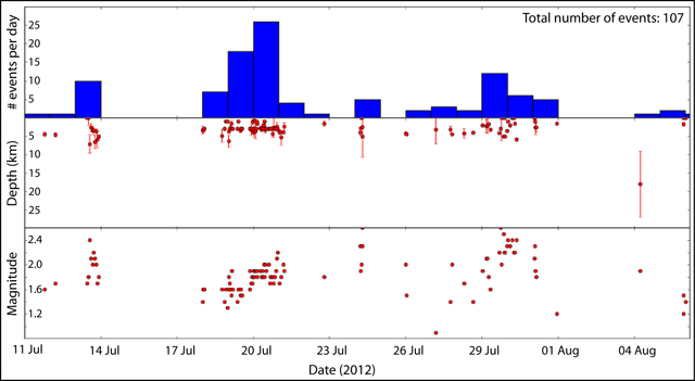 |
Figure 2. Seismicity at Tongariro during 11 July-6 August 2012, leading up to a phreatic eruption at 2350 on 6 August. Shown are the number of seismic events per day (107 in total, top panel), the depth at which each event occurred (and associated error bars, middle panel), and the magnitude of each event (bottom panel). Courtesy of GeoNet. |
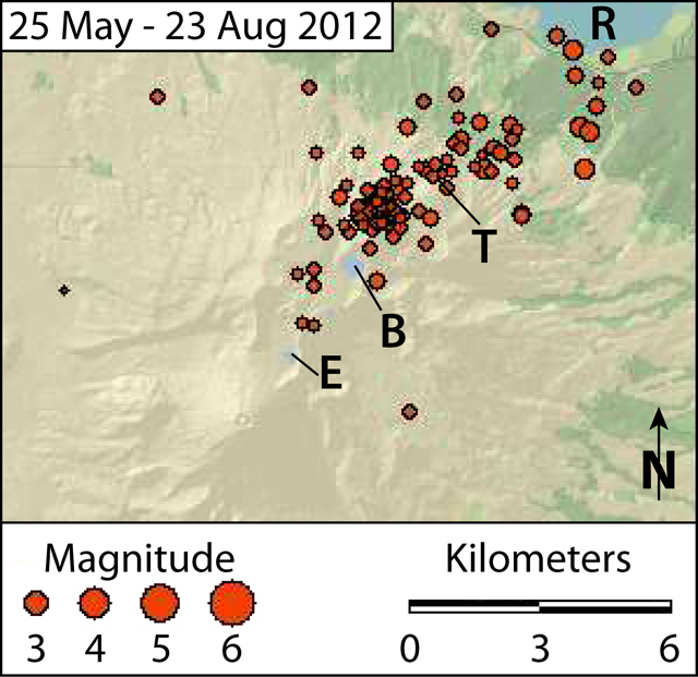 |
Figure 3. Mapped epicenters of seismic events recorded at Tongariro during 25 May-23 August 2012. A phreatic eruption occurred late on 6 August (see figure 2). During the precursory activity (late July and early August), seismicity concentrated between Emerald Lake (E) and Lake Rotoaira (R), with a cluster between Blue Lake (B) and Te Maari Craters (T). Courtesy of GeoNet. |
By 23 July, GeoNet had deployed four portable seismometers and had sampled springs and fumaroles. They reported that provisional analyses of gas samples indicated a marked increase in volcanic gases above typical mixtures of hydrothermal and volcanic gas signatures (see subsection "Ash and gas analyses" for detail). By 31 July, GeoNet had also installed a GPS instrument to monitor any deformation.
Phreatic eruption. At 2352 on 6 August, a phreatic eruption occurred from a vent located within the Te Maari Craters area. An explosion generated seismic signals that lasted a few minutes, followed by a series of discrete small earthquakes during the next few tens of minutes. Within 35 minutes, GeoNet posted an Alert Bulletin announcing that ashfall had been reported; the Volcano Alert Level was raised to 2 and the Aviation Colour Code was raised to Red. Taupo Civil Defense responded by closing State Highways 1 and 46 (to the E and N of Tongariro, respectively).
Approximately one hour after the eruption, the Cooperative Institute for Meteorological Satellite Studies (CIMSS) observed in satellite imagery that an ash plume was drifting more than 50 km E from Tongariro (figure 4). They also reported that airports had cancelled flights at Gisborne (210 km ENE), Rotorua (120 km NNE), Taupo (60 km NE), and Palmerston North (135 km S).
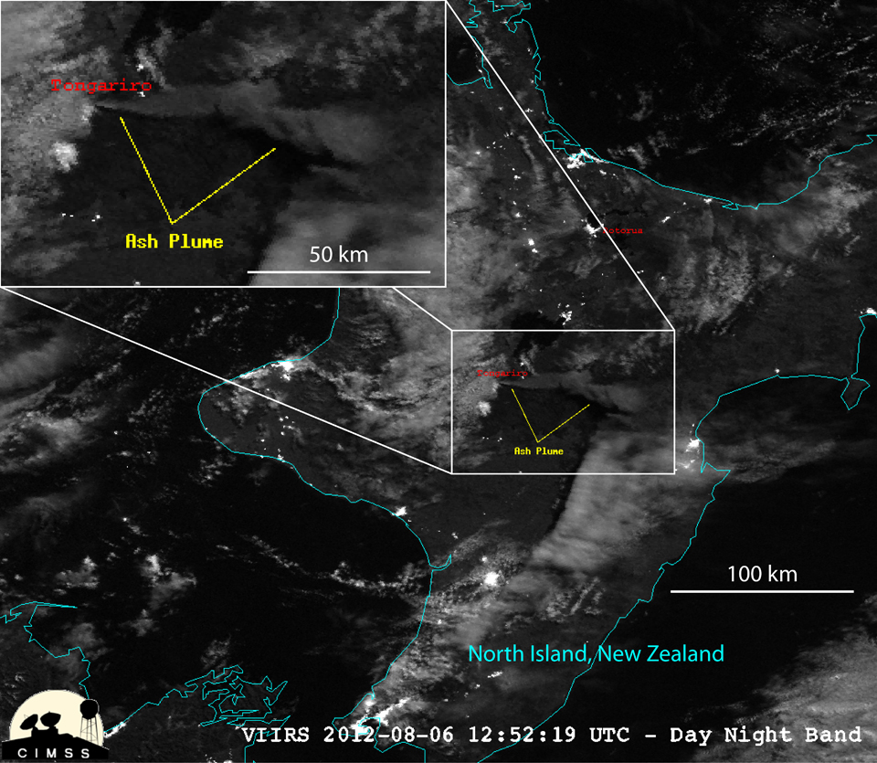 |
Figure 4. A Visible Infrared Imaging Radiometer Suite (VIIRS) image acquired by the Suomi National Polar-orbiting Partnership (NPP) satellite at 1252 UTC on 6 August 2012 (0052 NZST on 7 August) showing an ash plume drifting more than 50 km E from Tongariro, after the phreatic explosion ~1 hour earlier. The windward end of the plume remains over the volcano, implying ongoing emissions. In the main image, the North Island of New Zealand is outlined in teal, and Rotorua is labeled to the N of the plume. In both images, the ash plume is labeled in yellow, and Tongariro is labeled in red, just W of the plume. Courtesy of CIMSS. |
GeoNet reported that no volcanic tremor occurred before or after the event, and the Aviation Colour Code was reduced to Orange ~12 hours later (about 1200 on 7 August), and reduced again the next day (1500 on 8 August).
GeoNet conducted an observation flight on 8 August and photographed a variety of features discussed and illustrated in more detail below. They included: (1) a new vent area residing in a small crater, and associated steaming fissures, (2) a debris flow, and (3) impact craters.
The new vent(s) are located in the Upper Te Maari Craters area (figure 5a); low clouds prevented scientists from viewing areas higher than the lowest parts of Upper Te Maari Crater. Photographs of the area revealed a nearby steaming eruptive fissure, and more intense steaming in areas of ground that had been steaming prior to the eruption (figure 5b).
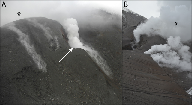 |
Figure 5. Photographs taken after Tongariro's 6 August 2012 phreatic eruption showing the Upper Te Maari vent area. In (A) the view is looking SE towards Upper Te Maari crater, with areas of fumaroles and a new vent on the outer edge of the crater (indicated by the arrow). (B) is looking NW showing vents along a fissure around the S side of Upper Te Maari crater. Upper Te Maari crater is indicated in each photo with the '*' symbol. Both photographs were taken during a morning observation flight on 8 August 2012. Courtesy of GeoNet. |
A debris flow generated by the phreatic eruption comprised rock and soil debris that blocked a stream valley draining NW from the Te Maari Craters area (figure 6). GeoNet reported water ponding around the edges, and ash that had been remobilized into slurry flows. GeoNet noted that areas of the debris flow (especially in the upper sections) had eroded into the substrate (figure 6a).
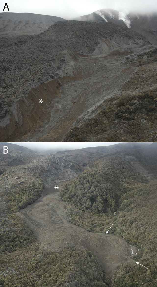 |
Figure 6. Upper (A) and lower (B) portions of the debris flow generated by the 6 August 2012 phreatic eruption at Tongariro. The debris flow extended down a stream valley draining NW from the Te Maari Craters (steaming areas visible in the top-most portion of (A)). White asterisks in both photos indicate regions where the debris flow eroded into the substrate. White arrows in (B) indicate areas of newly ponded water at the edges of the flow. Courtesy of GeoNet. |
The explosion ejected blocks of lava up to 2 km from the Te Maari Craters area, leaving impact craters in vegetation and ground surfaces (figure 7). All blocks were angular, and none were steaming or surrounded by burnt vegetation; GeoNet thus concluded that the blocks comprised old (non-juvenile) lava(s) ejected from the vent area.
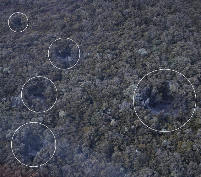 |
Figure 7. Blocks of lava ejected up to 2 km from the Te Maari Craters area during the phreatic explosion on 6 August 2012 left impact craters in vegetation and ground surfaces (circled). Courtesy of GeoNet. |
Ash and gas analyses. Textural analyses indicated that the ash emitted during the 6 August explosion contained little-to-no fresh (juvenile) lava, suggesting that the eruption was primarily steam driven (phreatic). GeoNet also reported that analysis of the fluorine content of the ash indicated that, except in the immediate vicinity of the volcano, there were little health or agricultural concerns.
For 9 August, GeoNet reported emissions of 2,100 tons/day of SO2, 3,900 tons/day of CO2, and 364 tons/day of H2S from vents. Sulfur (H2S) smells were reported in downwind locations during 11-12 August, and further reports were filed from the Manawatu region on 15 August. GeoNet attributed the sulfur odors to "passive degassing of magma beneath the surface of Tongariro."
Heavy rains spawn minor lahar. In concert with the 11 August release of a new, updated hazard map of Tongariro (figure 8), GeoNet warned motorists not to stop their vehicles along Highway 46 (N of Tongariro) due to hazards in that area. Following heavy rains the next morning, a minor flood/lahar crossed State Highway 46 near the S tip of Lake Rotoaira (at a location ~6 km W of Rangipo). According to the New Zealand Herald, a driver described 13-cm-deep mud crossing the road at 0830 that day. Scientists at GNS Science stressed that the lahar was not a direct result of an eruptive process, and a resident reported that the area was commonly washed out during heavy rains.
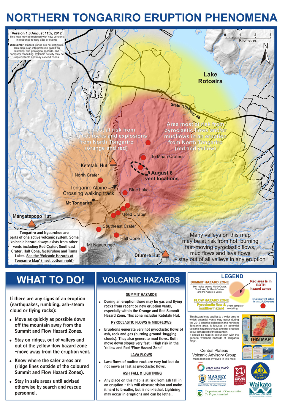 |
Figure 8. The updated hazard map released by GeoNet on 11 August 2012, which includes the 6 August vents seen in Tongariro's Te Maari Craters area (dashed black circle). As seen in the legend, the map indicates the locations prone to pyroclastic flows and mudflows (shaded yellow) and an area within a 3 km radius of the summit that is prone to gas hazards and flying rocks (shaded orange). Where the two zones overlap, the map is shaded red. Red dots indicate eruptive vents active in the last 27,000 years. Orange triangular "hut" icons indicate nearby mountain refuges. The larger poster conveys extensive hazard information. Note disclaimer (upper left) and wide range of agency collaboration (lower right) in map production. The highest peak of the complex is at Ngāuruhoe (near the SW corner of the map). As stated in the comment in the SW corner of the map, "Tongariro and Ngāuruhoe are parts of one active volcanic system." Courtesy of GeoNet. |
Ten days after the phreatic explosion, GeoNet reduced the Volcano Alert Level to 1, stating that minor eruptive activity, required for Volcanic Alert Level 2, had ceased. The Aviation Colour Code remained at Yellow as of 24 August 2012.
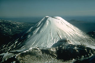
Geological Summary. Tongariro is a large volcanic massif, located immediately NE of Ruapehu volcano, that is composed of more than a dozen composite cones constructed over a period of 275,000 years. Vents along a NE-trending zone extending from Saddle Cone (below Ruapehu) to Te Maari crater (including vents at the present-day location of Ngauruhoe) were active during several hundred years around 10,000 years ago, producing the largest known eruptions at the Tongariro complex during the Holocene. North Crater stratovolcano is truncated by a broad, shallow crater filled by a solidified lava lake that is cut on the NW side by a small explosion crater. The youngest cone, Ngauruhoe, is also the highest peak.
Information Contacts: GeoNet, a collaboration between theEarthquake Commission and GNS Science (URL: http://www.geonet.org.nz/); GNS Science, Wairakei Research Center, Private Bag 2000, Taupo 3352, New Zealand (URL: http://www.gns.cri.nz/); Earthquake Commission (EQC), PO Box 790, Wellington, New Zealand (URL: http://www.eqc.govt.nz/); The Cooperative Institute for Meteorological Satellite Studes (CIMSS), a collaboration between theUniversity of Wisonsin-Madison, theNational Oceanic and Atmospheric Administration, and theNational Aeronautics and Space Administration, Space Science and Engineering Center, 1225 W. Dayton St., Madison, WI 53706 (URL: http://cimss.ssec.wisc.edu/); University of Wisconsin-Madison (UW-Madison) (URL: http://www.wisc.edu/); National Oceanic and Atmospheric Administration (NOAA) (URL: http://www.noaa.gov/about-noaa.html); National Aeronautics and Space Administration (NASA) (URL: http://www.nasa.gov/); New Zealand Herald (URL: http://www.nzherald.co.nz/).