Report on Krakatau (Indonesia) — December 2012

Bulletin of the Global Volcanism Network, vol. 37, no. 12 (December 2012)
Managing Editor: Richard Wunderman.
Krakatau (Indonesia) September 2012 eruption ejects ash; lava flows reach the sea
Please cite this report as:
Global Volcanism Program, 2012. Report on Krakatau (Indonesia) (Wunderman, R., ed.). Bulletin of the Global Volcanism Network, 37:12. Smithsonian Institution. https://doi.org/10.5479/si.GVP.BGVN201212-262000
Krakatau
Indonesia
6.1009°S, 105.4233°E; summit elev. 285 m
All times are local (unless otherwise noted)
One of our previous reports on Krakatau (BGVN 36:08) discussed two eruption episodes, one spanning from 25 October 2010 to March 2011 and another beginning in August 2011 and continuing through the end of that report, around 1 October 2011. During the last two weeks of September 2011 volcanic earthquake swarms and diffuse emissions persisted. In November 2011, the photographer and guide Øystein Lund Andersen visited Krakatau and observed mild Strombolian explosions (BGVN 37:11).
This report summarizes behavior chiefly during 1 October 2011 through early October 2012. Eruptions around early September 2012 deposited ash on towns in Sumatra, and lava flows extended the shoreline of the island (Anak Krakatau) by ~100 m. The Alert Level was lowered after that and remained low into at least mid-January 2013. Figure 30 is an index map showing the location of the famous caldera Krakatau, located in the Sunda Strait (E of Sumatra and W of Java). The smaller feature Anak Krakatau grew to form an island well after the 1883 eruption and continues as the active center.
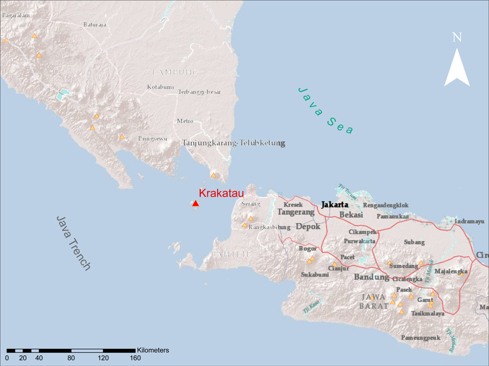 |
Figure 30. An index map showing the location of Krakatau. Small yellow triangles indicate other Holocene volcanoes (from the current Global Volcanism Program database). Created by GVP staff from ARC software. |
Activity during October 2011-early September 2012. The Alert Level was raised to 3 (on a scale of 1-4) on 30 September 2011, prohibiting visitors and residents from approaching within 2 km of the active crater. On 8 October 2011, a Jakarta Post article stated that activity at Krakatau was increasing; the number of seismic events on 6 October was 5,204; on 7 October, 5,543; and on 8 October, 5,883.
On 26 January 2012, CVGHM lowered the Alert Level from 3 to 2, noting that the number of tremor events had decreased significantly. The lowered Alert Level excluded visitors and residents from approaching within 1 km of the active crater.
During 1 June-1 September 2012, CVGHM's visual observations were often prevented by fog cover. When views were clear during June, observers saw occasional diffuse white plumes above the crater. In June, July, and August, the respective seismic events totaled 1,075, 807, and 2,335. Detailed seismicity during 1 June-2 September 2012 is cataloged in table 8.
Table 8. Type and occurrence of earthquakes and tremor at Krakatau during 1 June-2 September 2012; '-' indicates data not reported. Courtesy of CVGHM.
| Date | Deep volcanic | Shallow volcanic | Local tectonic | Distant tectonic | Harmonic tremor | "Hot air blast" tremor | Seismic tremor |
| Jun 2012 | 63 | 837 | 1 | 5 | 17 | 152 | -- |
| Jul 2012 | 80 | 679 | 11 | 6 | -- | 31 | -- |
| Aug 2012 | 165 | 1436 | 9 | 6 | 139 | 547 | 34 |
| 1-2 Sep 2012 | 7 | 79 | -- | -- | -- | 15 | 20 |
Seismicity increased on 2 September 2012. CVGHM recorded continuous tremor, and a Strombolian eruption ejected lava 200-300 m above the crater. At times, residents heard booming sounds that rattled windows. On 3 September, the Darwin Volcanic Ash Advisory Centre (VAAC) reported that ash plumes rose to altitudes of 2.4-4.3 km and drifted 35-95 km N. The Jakarta Globe (citing the state news agency Antara News) reported that a dense ash plume had drifted N, reaching a number of areas in Lampung (the most southerly province of Sumatra), and blanketing Lampung's capital, Bandar Lampung (~75 km NNW of Krakatau; figure 31), with a thin layer of ash.
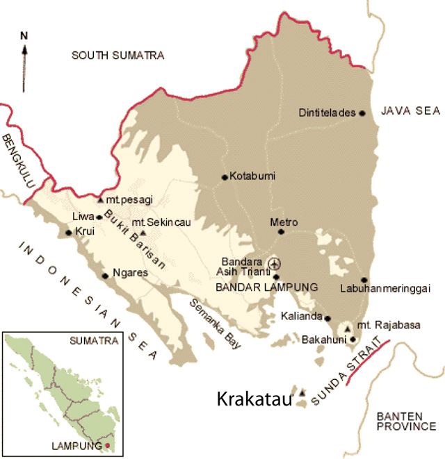 |
Figure 31. Sketch map showing Krakatau and Sumatra's Lampung province (Indonesia) including the capital, Bandar Lampung, the scene of September 2012 ashfall from the post-1927 vent, Anak Krakatau (the small island labeled with a triangle). Adapted from a brochure offered for tourists (Indonesia Destination & Travel Information Guide; baliwww.com). |
Ashfall on 2 September prompted officials to recommend that residents and tourists wear masks outside and not venture within 3 km of the volcano. The Jakarta Post indicated that government officials planned to distribute 680,000 masks to residents in a number of affected districts in anticipation of further Krakatau explosions. According to Antara News, less intense tremor continued on 4 September. A satellite image acquired by NASA's Earth Observatory on 4 September showed fresh lava flows descending Anak Krakatau's SE flank, extending the shoreline by about 100 m (figure 32).
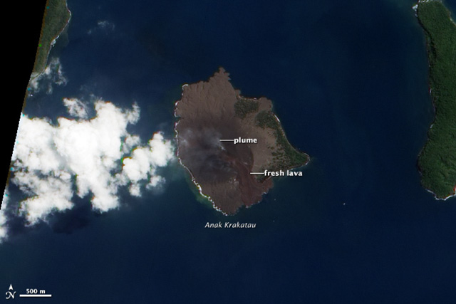 |
Figure 32. A natural-color satellite image of Anak Krakatau acquired by the Advanced Land Imager aboard Earth Observatory-1 on the morning of 4 September 2012. The NASA caption noted that fresh lava flows extended the SE shoreline by ~100 m. The ash plume drifted W. Courtesy of NASA Earth Observatory. |
September 2012 eruption and visit by Volcano Discovery. A Volcano Discovery group toured Krakatau during the first several days of September 2012 and observed what they noted was the largest explosion there in ten years. They noted that seismic activity (recorded by CVGHM) peaked on 2 September, with a day of continuous explosions and lava descending the volcano's E and W flanks. Photos showed lava entering the sea (figure 33).
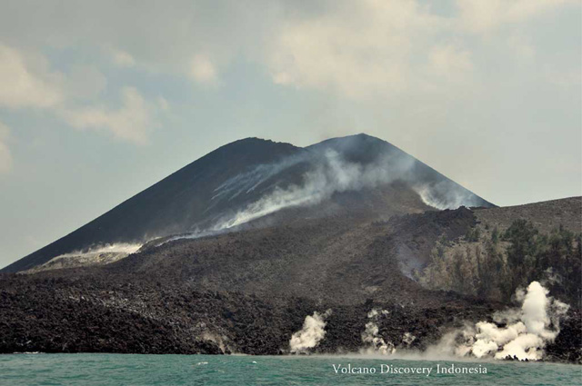 |
Figure 33. A lava flow from Anak Krakatau reaching the sea on 3 September 2012. Courtesy of Volcano Discovery. |
The Volcano Discovery group noted that the eruption had altered part of the S and W crater rim, splitting the rim into two parts. They saw an abundance of lava bombs on the volcano's flanks in the forest, indicating the force of the explosions. The group indicated that by 5 September, activity had greatly diminished and incandescence from the crater was absent. On 6 September, Krakatau was calm with limited seismic activity reported by the observatory.
On 8 September, the Jakarta Post also reported that seismic activity had greatly diminished during the previous two days. However, this news account noted that residents in Bandar Lampung still reported ashfall. The article also stated that ash from the eruption had damaged volcano-monitoring equipment.
2012 visits by Øystein Lund Andersen. As indicated in our previous report on Krakatau (BGVN 37:11), the photographer and guide Øystein Lund Andersen has visited Krakatau multiple times and his website contains good descriptions and photos of the volcano during these visits. The following describes his observations during 2012.
On 8 January 2012, during a 3-hour visit, Andersen observed no Strombolian activity, in contrast with his observation on 13 November 2011. On his next visit, during 12-14 February, he reported medium to heavy venting from the crater and fumarolic activity that was more intense than the activity during January. He noted continuous steam-and-gas emissions that rose 100-500 m and incandescence at night, but no eruptions.
During a visit on 6-7 April 2012, Andersen noticed that the S part of the crater was illuminated at night. He further reported that on 7 April, Krakatau started to produce small eruptions from the S part of the crater, the same side as the growing lava dome.
During 6-8 May, Andersen noted that activity at Krakatau had decreased somewhat in the previous several weeks. Steam plumes reached a height of 100-200 m and seemed less intense than during his visit in April. He noted incandescence at night, but it was less intense that the previous month. Andersen reported on 7 April: "footage taken by Pierre Fortine showed no sign of any lava dome, but the red glow that is often clearly visible at night from Verlaten, Lang, or Rakata are in fact multiple glowing vents (some of them were gas vents that were burning) and red hot material surrounding them. The lava dome that people have claimed to observe [through] February to April may have been destroyed during the last small eruptions that I reported of in April. Shallow earthquake data recorded by the Krakatau Volcano Observatory in Pasauran (PVMG) shows that the level of activity remains on the relative same level as last month."
During 2-3 June, he reported that activity had decreased since April and May. He stated that incandescence was almost non-observable, and steam plumes only rose 50-100 m on this visit (compared to 200 m in May), and were at times non-existent.
On 3 September 2012, Andersen wrote that he had heard continuous booming noises half way from Java, and that large booming sounds could be heard in the villages of Carita and Anyar (or Anyer), neighboring villages on the W coast of Java, about 50 km ESE of the volcano. As he approached the volcano, he noted a high plume from the main vent and the ejection of lava bombs to heights of up to 300 m. An area on the SE shore also emitted a large steam plume. According to Andersen: "The local crew/guides who joined our group looked very surprised and worried, as we all noticed these major changes. I first thought this was the result of new geothermal activity, but first realized later that this was in fact a new lava flow." According to Andersen, the lava flow had extended the seashore on the E side by up to 100 m, and the E and W part of the crater walls had experienced a partial collapse (figure 34).
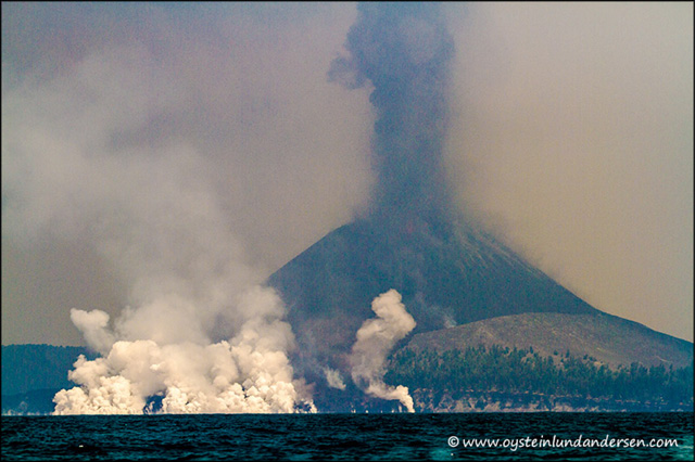 |
Figure 34. New lava extending the seashore on the E side of Anak Krakatau on 3 September 2012. Courtesy of Øystein Lund Andersen. |
On a visit during 6-7 October 2012, Andersen observed no activity other than a weak and irregular steam plume and, at night, "some small spots of glowing lava, near and on the lava flow on the western flank." On this visit, he studied the new lava flow. He reported that the lava had flowed down both the W and E sides of the volcano, leaving deep scars on both flanks. According to Andersen, news accounts had reported the lava flow on the E flank, but few had noted the one on the W flank, which was significant, although not as great as the one on the E flank.
Geological Summary. The renowned Krakatau (frequently mis-named as Krakatoa) volcano lies in the Sunda Strait between Java and Sumatra. Collapse of an older edifice, perhaps in 416 or 535 CE, formed a 7-km-wide caldera. Remnants of that volcano are preserved in Verlaten and Lang Islands; subsequently the Rakata, Danan, and Perbuwatan cones were formed, coalescing to create the pre-1883 Krakatau Island. Caldera collapse during the catastrophic 1883 eruption destroyed Danan and Perbuwatan, and left only a remnant of Rakata. This eruption caused more than 36,000 fatalities, most as a result of tsunamis that swept the adjacent coastlines of Sumatra and Java. Pyroclastic surges traveled 40 km across the Sunda Strait and reached the Sumatra coast. After a quiescence of less than a half century, the post-collapse cone of Anak Krakatau (Child of Krakatau) was constructed within the 1883 caldera at a point between the former Danan and Perbuwatan cones. Anak Krakatau has been the site of frequent eruptions since 1927.
Information Contacts: Center of Volcanology and Geological Hazard Mitigation (CVGHM), Jalan Diponegoro 57, Bandung 40122, Indonesia (URL: http://www.vsi.esdm.go.id/); Darwin Volcanic Ash Advisory Centre (VAAC), Bureau of Meteorology, Northern Territory Regional Office, PO Box 40050, Casuarina, NT 0811, Australia (URL: http://www.bom.gov.au/info/vaac/); NASA Earth Observatory (URL: http://earthobservatory.nasa.gov and http://eo1.gsfc.nasa.gov/); The Jakarta Post (URL: http://www2.thejakartapost.com); Antara News (URL: http://www.antaranews.com/en/); Volcano Discovery (URL: http://www.volcanodiscovery.com); Indonesia Destination & Travel Information Guide (URL: http://baliwww.com); Øystein Lund Andersen (URL: http://www.oysteinlundandersen.com/).