Report on Heard (Australia) — January 2013
Bulletin of the Global Volcanism Network, vol. 38, no. 1 (January 2013)
Managing Editor: Richard Wunderman.
Heard (Australia) Satellite imagery reveals lava flows in December 2012
Please cite this report as:
Global Volcanism Program, 2013. Report on Heard (Australia) (Wunderman, R., ed.). Bulletin of the Global Volcanism Network, 38:1. Smithsonian Institution. https://doi.org/10.5479/si.GVP.BGVN201301-234010
Heard
Australia
53.106°S, 73.513°E; summit elev. 2745 m
All times are local (unless otherwise noted)
We received an informal report from Matt Patrick (Hawaiian Volcano Observatory) on a new eruptive episode at Big Ben volcano, Heard Island (figure 16). He noted that MODVOLC thermal alerts reappeared at Heard in September 2012 after a four year hiatus (the last eruptive episode ended on 2 March 2008; BGVN 33:01), suggesting the start of a new eruptive episode at the volcano. Since Heard Island is unsettled and extremely isolated, monitoring of the volcano is possibly primarily through satellite imagery (Patrick, 2013).
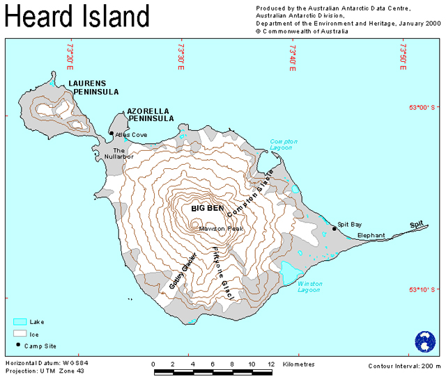 |
Figure 16. A contour map (interval = 200 m) showing the partly ice-covered Heard Island. At the time of map preparation, the brown areas were ice free. Produced and issued in January 2000 by the Australian Antarctic Data Centre, Department of the Environment and Heritage, Commonwealth of Australia. |
EO-1 Advanced Land Imager images collected through late 2012 and early 2013 confirm that eruptive activity resumed around September 2012, in the form of a low-level effusive style eruption similar to its other recent eruptions (figures 17 and 18). Patrick noted that the vent crater had enlarged significantly over the four years following the end of the last eruptive phase, March 2006-March 2008.
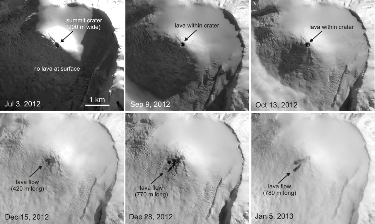 |
Figure 17. A series of images documenting the summit crater and subsequent lava advances at Mawson Peak, Heard Island from 3 July 2012 to 5 January 2013. The Earth Observing-1 (EO-1) satellite's Advanced Land Imager (ALI) Band 1 (panchromatic) images (10-m-pixel size) acquired several clear images on 3 July, 9 September, 13 October, 15 and 28 December 2012, and 5 January 2013. North is to the top of the photos. In the first three images the 200-m diameter crater at the summit of Mawson Peak is easily visible, and there is no evidence of activity outside of the crater. Courtesy of Matt Patrick. |
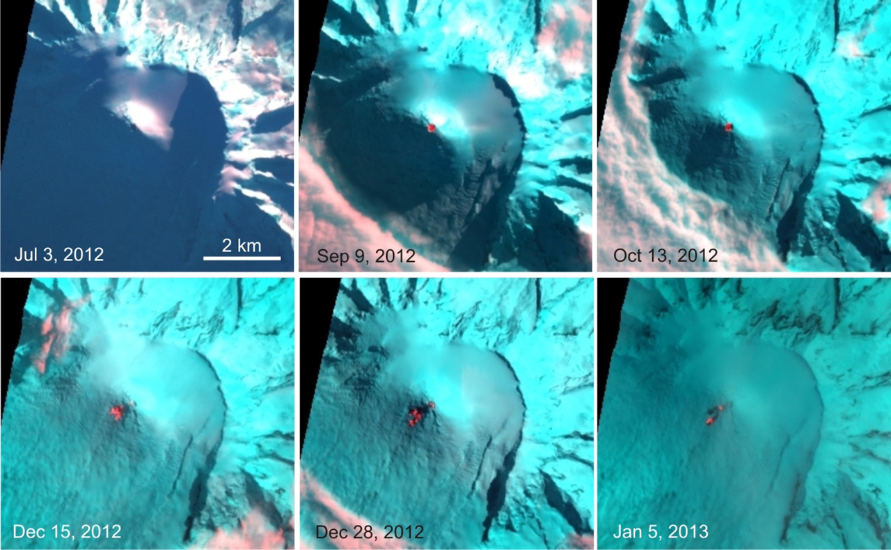 |
Figure 18. EO-1 ALI Band 10-3-2 RGB composites (30-m-pixel size) of the same series of images as in figure 17 (3 July 2012 to 5 January 2013). North is to the top of the photos. The red is the shortwave infrared band (Band 10, 2 microns); red pixels indicate high temperatures suggesting hot lava surfaces. As in figure 17, the 3 July 2012 image shows that the summit crater was cold, with no evidence of lava inside. However, the 9 September 2012 image clearly shows that elevated temperatures (and presumably lava) had appeared in the crater, consistent with the appearance of MODVOLC thermal alerts later that month. Therefore, this eruptive episode appears to have started around September. Courtesy of Matt Patrick. |
The 15 December 2012 image in figure 17 shows that a short lava flow from the summit was emplaced on the SW flank. The flow was ~420 m long and had two lobes. By 28 December, a flow consisting of two lobes (presumably the same flow as in the 15 December image) had reached 770 m SW of the summit crater. In the 5 January 2013 image this flow was 780 m long and had changed little over the previous week.
Figure 18 shows that the 9 September and 13 October 2012 images suggested active lava contained with the summit crater. The 15 and 28 December 2012 images showed elevated temperatures on the lava flow SW of the summit, suggesting it was active over this interval, which was consistent with the observed elongation of the flow in the visible images. Fewer high-temperature pixels in the 5 January 2013 image and the meager advancement observed in the visible images, suggested that the flow had stalled by this point.
Overall, the activity as of mid-March 2013 had consisted of lava within the crater and a lava flow of at least 770 m long emplaced SW of the crater. This low-level effusive activity is consistent with the previous three eruptive episodes observed in satellite images at Heard Island (Patrick and Smellie, in review). These three episodes, May 2000-November 2001 (BGVN 25:11, 26:02, 26:03, and 28:01), June 2003-July 2004 (BGVN 29:12), and March 2006-March 2008 (BGVN 31:05, 31:11, 32:03, 32:06, 33:01, and 35:09), each lasted 1-2 years. On this basis, Patrick suggested that this new eruptive episode may persist for a similar duration. MODVOLC thermal alerts were measured nearly continuously from 21 September 2012 through 24 February 2013.
References. Patrick, M., 2013, A new eruptive episode at Big Ben Volcano, Heard Island, informal communication to BGVN, 23 February 2013.
Patrick, M.R., and Smellie, J.L., in review, A spaceborne inventory of volcanic activity in Antarctica and southern oceans, 2000-2010, Antarctic Science, in review in 2013.
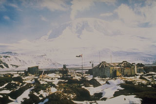
Geological Summary. Heard Island on the Kerguelen Plateau in the southern Indian Ocean consists primarily of the emergent portion of two volcanic structures. The large glacier-covered composite basaltic-to-trachytic cone of Big Ben comprises most of the island, and the smaller Mt. Dixon lies at the NW tip of the island across a narrow isthmus. Little is known about the structure of Big Ben because of its extensive ice cover. The active Mawson Peak forms the island's high point and lies within a 5-6 km wide caldera breached to the SW side of Big Ben. Small satellitic scoria cones are mostly located on the northern coast. Several subglacial eruptions have been reported at this isolated volcano, but observations are infrequent and additional activity may have occurred.
Information Contacts: Matt Patrick, Hawaiian Volcano Observatory (HVO), U.S. Geological Survey, PO Box 51, Hawai'i National Park, HI 96718, USA (URL: https://volcanoes.usgs.gov/observatories/hvo/); Australian Antarctic Data Centre, Department of the Environment and Heritage, Commonwealth of Australia (URL: https://data.aad.gov.au/database/mapcat/heard/heard_island.gif); MODVOLC, Hawai'i Institute of Geophysics and Planetology (HIGP) Thermal Alerts System, School of Ocean and Earth Science and Technology (SOEST), Univ. of Hawai'i, 2525 Correa Road, Honolulu, HI 96822, USA (URL: http://modis.higp.hawaii.edu/).