Report on Turrialba (Costa Rica) — February 2013

Bulletin of the Global Volcanism Network, vol. 38, no. 2 (February 2013)
Managing Editor: Richard Wunderman.
Turrialba (Costa Rica) Decreased seismicity and emissions in 2012
Please cite this report as:
Global Volcanism Program, 2013. Report on Turrialba (Costa Rica) (Wunderman, R., ed.). Bulletin of the Global Volcanism Network, 38:2. Smithsonian Institution. https://doi.org/10.5479/si.GVP.BGVN201302-345070
Turrialba
Costa Rica
10.025°N, 83.767°W; summit elev. 3340 m
All times are local (unless otherwise noted)
As noted by our previous report (BGVN 37:06), on 12 January 2012 Turrialba emitted ash for a few hours due to the opening of a vent, named 2012 Vent, on the SW inside slope of Central Crater. Since then, 2012 Vent has been an active contributor to the regular plume generation at the volcano. Our previous report noted activity through May 2012. This report primarily highlights activity through December 2012, based on online documents from the Observatorio Vulcanologico Sismologica de Costa Rica-Universidad Nacional (OVSICORI-UNA) showing a diminution in activity during 2012 compared to 2010 and 2011.
Seismicity. According to OVSICORI-UNA, the seismic activity at Turrialba in 2012 was characterized primarily by shallow and volcano-tectonic events concentrated in the upper part of the edifice, and minor seismicity in nearby faults. In general, seismicity was lower in 2012 than in 2011, and notably lower than that in 2010. Seismic activity climbed slightly during September-October 2012 (from about 20/day, peaking at 150/day on 13 October, and then declining back to normal values after 1 November; figure 30). OVSICORI-UNA noted that seismic activity in 2012 was caused by water and heat interactions causing gas pressure.
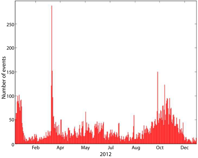 |
Figure 30. The number of seismic events registered per day at Turrialba during 2012. Courtesy of OVSICORI-UNA. |
Deformation. OVSICORI-UNA reported that during 2012 the distances between the Electronic Distance Measurement (EDM) station "Pilar" and several nearby reflectors contracted from 2 to 7 cm/year, with the highest value at the N reflector and lowest at the ENE and NE reflectors (see figure 31 for EDM station locations).
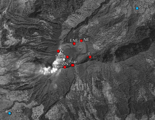 |
Figure 31. The location of geodetic monitoring stations at Turriabla during 2012. Red circles are reflectors of the EDM network, and measurements were made from the Pilar station (red square). Blue circles are permanent GPS stations (CAPI and GIBE). Courtesy of OVSICORI-UNA. |
Emissions. According to OVSICORI-UNA, the opening of the 2012 vent was not associated with new magmatic activity. Vent temperatures measured with a thermocouple were similar during 2010-2012, suggesting to OVSICORI-UNA a sustained and common magmatic source. Measured vent temperatures also correlated with CO2 and H2S gas emissions (figure 32).
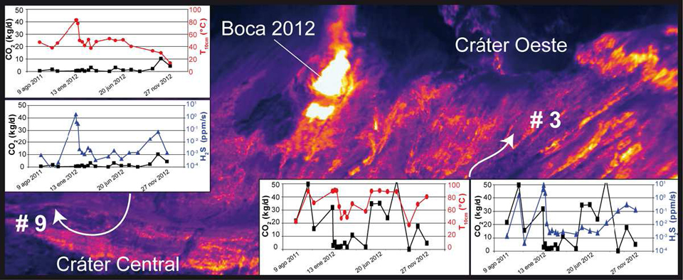 |
Figure 32. (Background image) Thermal image of Turrialba's W wall in Cráter Central (Central Crater) on 27 October 2012. Two vents are indicated, Boca 2012 (2012 Vent) and Cráter Oeste (West Crater). (Plots) For the measurement locations indicated by arrows, plots compare CO2 flux measurements (black) to both H2S flux measurements (blue) and thermal measurements acquired at 10-cm depth (red). Courtesy of OVSICORI-UNA; thermal photo taken by G. Avard. |
OVSICORI-UNA noted that gas emissions during 2012 had decreased considerably compared to those during 2010 and 2011. OVSICORI-UNA suggested that this decrease might be due to various factors, including a decline in rainfall that resulted in less water vapor, the primary component of the emissions. In a report discussing activity during January-February 2013, OVSICORI-UNA noted that the emissions from 2012 Vent had decreased, even though nighttime incandescence could be observed. Emissions drifted primarily NW during 2012.
Figures 33 and 34 summarize SO2 measurements from both miniature Differential Optical Absorption Spectrometer (mini-DOAS, fluxes) and OMI satellite data (masses). SO2 fluxes were lower than those in 2010-2011 when fluxes often reached above 1,000 tons/day (and in one case, nearly 4,000 tons/day; figure 34).
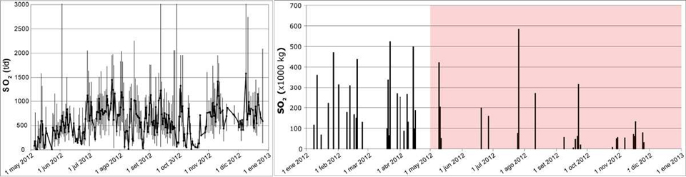 |
Figure 33. (Left) Daily SO2 flux (metric tons/day) at Turrialba measured by a mini-DOAS station at La Central school, ~2.2 km SW of West Crater, between 1 May 2012 and 1 January 2013. (Right) SO2 mass (uncorrected for any noise) emitted by Turrialba as recorded by NASA's Ozone Monitoring Instrument (OMI) aboard the AURA satellite during 2012. The SO2 mass corresponds to the total mass detected by the OMI sensor in the Central America area at 1800-1900 UTC. According to OVSICORI, both mini-DOAS and OMI measurements were consistent and of the same magnitude. The red-shaded area in the satellite data represents the time period corresponding to that of the mini DOAS data. Courtesy of OVSICORI-UNA and NASA-OMI. |
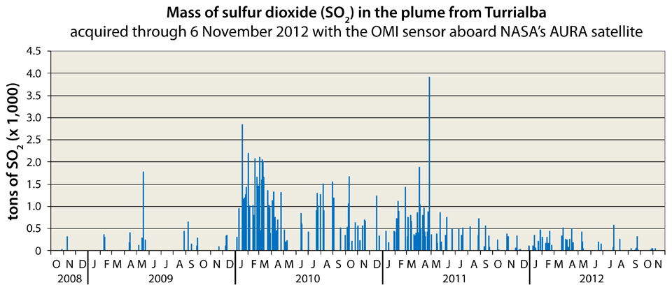 |
Figure 34. SO2 mass emitted by Turrialba as recorded by NASA's OMI instrument aboard the AURA satellite between 1 October 2008 and 6 November 2012. These represent masses in the atmospheric column that are thought to have roughly 1 day residence times. Courtesy of NASA-OMI. |
As in previous years, rain and fog absorbed volcanic gases in 2011 and 2012, producing acid rain with consequent damage and destruction to vegetation, especially in downwind areas in the sector sweeping clockwise from SW to N from the vents (figure 35).
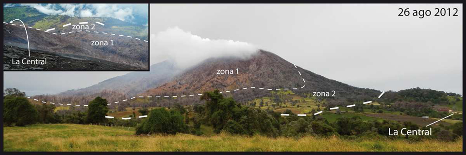 |
Figure 35. Annotated photo of Turrialba taken on 26 August 2012. The vegetation on the top and on the flanks of the edifice (zone 1) showed severe effects such as necrosis. The pasture vegetation (zone 2), used for milk production, turned yellowish (chlorosis). Interestingly, part of the native vegetation such as the tall trees (Quercus species) showed a stronger resistance to environmental acidification. Courtesy of OVSICORI-UNA; photo taken by G. Avard. |
OVSICORI-UNA observed that hydrothermal activity modified the mineralogy and decreased the cohesion of the rocks in contact with the fluids, which alter and reduce the stability of the slopes of the volcanic edifice, triggering gravitational collapses, rockfalls, and strong erosion during the main rain events. These phenomena were especially observed after storms on 15 August and in November 2012, when coarse and fine material was transported from the walls to the bottom of Central Crater, deepening the W and NW gullies.
In an M.S. thesis, Rivera (2011) compared SO2 concentrations in Turriabla's volcanic plume using a ground-based mini-DOAS and three new data analysis techniques using NASA's OMI instrument. The three new techniques were the MODIS smoke estimation, OMI SO2 lifetime, and OMI SO2 transect techniques. All four techniques involve UV sensor analysis. She found that the OMI SO2 lifetime technique provided qualitative agreement between the ground-based and satellite-based data, while the OMI transect technique provided occasional quantitative agreements with the mini-DOAS measurements. The MODIS smoke estimation technique was inaccurate in estimating SO2 emission rates.
Reference. Rivera, A.M., 2011, Comparisons between OMI SO2 data and ground-based SO2 measurements at Turrialba volcano, M.S. Thesis, Michigan Technological University.
Geological Summary. Turrialba, the easternmost of Costa Rica's Holocene volcanoes, is a large vegetated basaltic-to-dacitic stratovolcano located across a broad saddle NE of Irazú volcano overlooking the city of Cartago. The massive edifice covers an area of 500 km2. Three well-defined craters occur at the upper SW end of a broad 800 x 2200 m summit depression that is breached to the NE. Most activity originated from the summit vent complex, but two pyroclastic cones are located on the SW flank. Five major explosive eruptions have occurred during the past 3500 years. A series of explosive eruptions during the 19th century were sometimes accompanied by pyroclastic flows. Fumarolic activity continues at the central and SW summit craters.
Information Contacts: Observatorio Vulcanologico Sismologica de Costa Rica-Universidad Nacional (OVSICORI-UNA), Apartado 86-3000, Heredia, Costa Rica (URL: http://www.ovsicori.una.ac.cr/).