Report on Lascar (Chile) — July 2013

Bulletin of the Global Volcanism Network, vol. 38, no. 7 (July 2013)
Managing Editor: Richard Wunderman.
Lascar (Chile) Seismicity, glow, gray plumes, and other anomalies suggest April 2013 eruption
Please cite this report as:
Global Volcanism Program, 2013. Report on Lascar (Chile) (Wunderman, R., ed.). Bulletin of the Global Volcanism Network, 38:7. Smithsonian Institution. https://doi.org/10.5479/si.GVP.BGVN201307-355100
Lascar
Chile
23.37°S, 67.73°W; summit elev. 5592 m
All times are local (unless otherwise noted)
Láscar volcano lies within the Andes mountains [of northern Chile (figure 41)]. The Servicio Nacional de Geología y Minería (SERNAGEOMIN) furnishes on line reports on Láscar. The Observatorio Volcanológico de los Andes del Sur (OVDAS) in Temuco monitors the volcano. OVDAS... monthly and special reports [from the SERGEOMIN website], unless otherwise noted, formed the basis of this report. OVDAS monitors Láscar with several webcams, with GPS, and with airborne and remote sensing surveillance (eg. Landast). Their tool kit also includes findings from images gathered by OMI (The Ozone Monitoring Instrument on the NASA Aura satellite). Observatory volcanologists reported plume and seismic activity during February-March 2012, and again during March-April 2013. Emissions during early April 2013 were interpreted by authorities as a weak eruption.
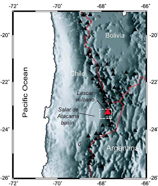 |
Figure 41. Láscar volcano, in the Andes region of Chile and adjacent to Bolivia and Argentina. The white box surrounding Láscar engulfs a high-altitude portion of the Atacama desert (Salar de Atacama in Spanish), as discussed further below. Courtesy of Visible Earth. NASA. (Retrieved 2011-01-02) |
In 2012, the volcano monitoring network recorded 1,679 seismic events; about 1,300 of these were hybrid earthquakes (HB) (table 4). Seismic activity increased sharply between 29 and 31 January 2012. A swarm with a total of 59 that were volcano-tectonic (VT); 491 that were long period (LP); and one that was hybrid (HB).During 1-15 February, a total of ~350 seismic events detected, averaging ~21 per day. This included 233 LP signals. Visible activity consisted of pulsating columns of gasses reaching 50-250 m height.
Table 4. A tabulation containing Láscar's 2012 Alert Level, seismic activity, and hazard status during 2012. Regarding hazard status, low risk corresponds to Green (G) and intermediate risk corresponds to Yellow (Y). Collated from OVDAS/SERNAGEOMIN reports.
| 2012 | Jan | Feb | Mar | Apr | May | Jun | Jul | Aug | Sep | Oct | Nov | Dec |
| Alert Level | Yellow | Yellow | Green | Green | Green | Green | Green | Green | Green | Green | Green | Green |
| Seismic events | 598 | 350 | 99 | 92 | 80 | 91 | 63 | 83 | 52 | 55 | 65 | 51 |
| VT events | 82 | 92 | 22 | 4 | 16 | 14 | 3 | 5 | -- | 55 | 65 | 5 |
| LP events, # | 507 | 233 | 77 | 88 | 64 | 76 | 70 | 78 | 52 | -- | -- | 45 |
| HB | 1 | 1 | -- | -- | -- | 1 | -- | -- | -- | -- | -- | -- |
In 2013, the volcano monitoring network recorded 506 seismic events. About 70% of these occurred during July (table 5). There were episodes of gas emissions, increased temperatures and seismic events starting in March and continuing through 10 April. This behavior prompted OVDAS to examine the likelyhood of an eruption. In March 2013, cameras detected mainly white gas columns reaching heights to 600 m above the crater.
Table 5. A tabulation containing Láscar's Alert Levels, seismic activity, hazard status, and plume color observations from February to October 2013. Collated from OVDAS/SERNAGEOMIN reports.
| 2013 | 01-28 Feb | 01 Mar-04 Apr | 05-15 Apr | 01-14 May | 15-31 May | 01-15 Jul | 16-30 Jul | 16-31 Aug | 01-15 Sep |
| Alert Level | Green | Yellow | Yellow | Yellow | Yellow | Yellow | Yellow | Yellow | Green |
| Seismic events | 43 | 57 | 18 | 5 | 8 | 116 | 245 | 7 | 2 |
| VT events | 3 | 2* | 3 | 3 | 4 | 92 | 226 | 6 | 1 |
| LP events | 40 | 55 | 15 | 2 | 4 | 24 | 19 | 1 | 1 |
| HB | -- | -- | -- | -- | -- | 8 out of 24 | 11 out of 19 | -- | -- |
| main plume color | -- | -- | white/gray | -- | -- | brown | brown | white | -- |
During the nights of 2-4 April incandescence appeared in the active crater. Also on 3 April gases emitted... fluctuated between white and gray, the latter taken as indicative of ash emissions. The resulting plume rose 320 m and drifted SE. No anomalous SO2 was seen in OMI satellite data. The OVDAS/SERNAGEOMIN geologists issued a special report on 10 April 2013 discussing a 9 April flyby at 1115 in a helicopter. The observers saw intense fumarolic activity along the inner walls of the crater; the emitted plume was steady, white to brown, and smelled of sulfur (figure 42). A thermal imager that day detected temperatures of ~600°C at the bottom of the crater (figure 43). Although gases often thwarted observations of the crater floor, some deformation seemingly took place there suggestive of a rise of magma.
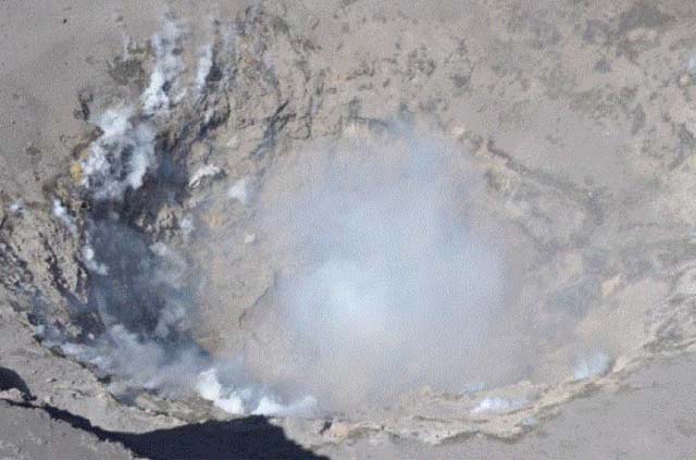 |
Figure 42. Visible light photo of the active crater at Láscar taken during an overflight on 9 April 2013. Courtesy of OVDAS/SERNAGEOMIN. |
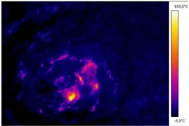 |
Figure 43. Thermal image of the active crater at Láscar showing computed temperatures at ~600°C (the scale maximum). Taken during the 9 April 2013 overflight. Courtesy of OVDAS/SERNAGEOMIN. |
During 1-17 July 2013, Láscar's cameras observed mainly brown-colored outgassing. The plumes reached a maximum heights of 500 and 1,000 m on 1 and 13 [July], respectively. Incandescence occurred on the nights of 1 and 2 July. After mid-July, the seismic activity tapered off to 10 or fewer events during the months of August and September. Láscar emitted white plumes on 4 November 2013 (figure 44).
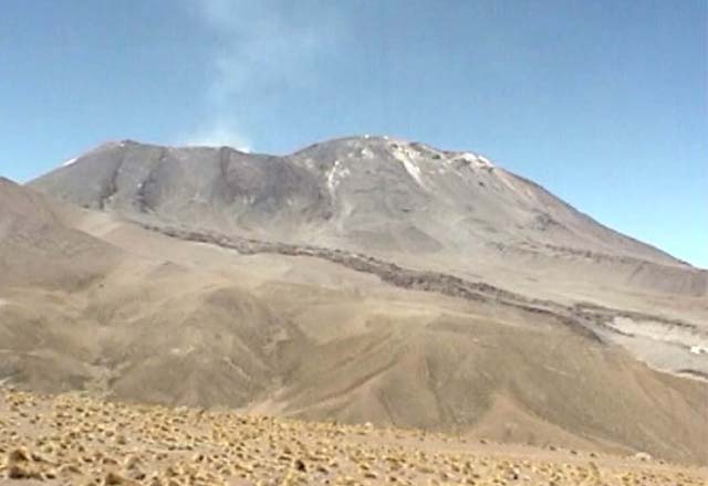 |
Figure 44. Webcam image of Láscar volcano, as seen amid calm conditions on 4 November 2013, capped by a faint white plume. Courtesy of OVDAS/SERNAGEOMIN. |
Geological Summary. Láscar is the most active volcano of the northern Chilean Andes. The andesitic-to-dacitic stratovolcano contains six overlapping summit craters. Prominent lava flows descend its NW flanks. An older, higher stratovolcano 5 km E, Volcán Aguas Calientes, displays a well-developed summit crater and a probable Holocene lava flow near its summit (de Silva and Francis, 1991). Láscar consists of two major edifices; activity began at the eastern volcano and then shifted to the western cone. The largest eruption took place about 26,500 years ago, and following the eruption of the Tumbres scoria flow about 9000 years ago, activity shifted back to the eastern edifice, where three overlapping craters were formed. Frequent small-to-moderate explosive eruptions have been recorded since the mid-19th century, along with periodic larger eruptions that produced ashfall hundreds of kilometers away. The largest historical eruption took place in 1993, producing pyroclastic flows to 8.5 km NW of the summit and ashfall in Buenos Aires.
Information Contacts: Oficina Nacional de Emergencia Ministerio del Interior (ONEMI) (URL: http://www.onemi.cl/); Servicio Nacional de Geología y Minería (SERNAGEOMIN) (URL: http://www.sernageomin.cl/volcanes.php); Observatorio Volcanológico de los Andes del Sur (OVDAS), Temuco (URL: http://www.sernageomin.cl/volcan-observatorio.php); Jose G. Viramonte, Instituto Inenco-Geonorte, Universidad National De Salta-CONICET; Servicio Meteorológico Nacional-Fuerza Aérea Argentina, 25 de mayo 658, Buenos Aires, Argentina; and Buenos Aires Volcanic Ash Advisory Center (VAAC) (URL: http://www.smn.gov.ar/vaac/buenosaires/productos.php).