Report on Cerro Hudson (Chile) — December 2013
Bulletin of the Global Volcanism Network, vol. 38, no. 12 (December 2013)
Managing Editor: Richard Wunderman.
Cerro Hudson (Chile) October 2011 earthquakes and eruption with ash, causing evacuation
Please cite this report as:
Global Volcanism Program, 2013. Report on Cerro Hudson (Chile) (Wunderman, R., ed.). Bulletin of the Global Volcanism Network, 38:12. Smithsonian Institution. https://doi.org/10.5479/si.GVP.BGVN201312-358057
Cerro Hudson
Chile
45.9°S, 72.97°W; summit elev. 1905 m
All times are local (unless otherwise noted)
A large eruption occurred at Cerro Hudson on 8 August 1991 (BGVN 16:07-18:02), which was followed by minor non-eruptive activity that caused sulfurous odors, increased river flows and turbidity, and noise at least through early 1995 (BGVN 20:02). This report describes a minor eruption during 25-26 October 2011. Cerro Hudson is located in Patagonia in the Aysén Region of Chile (figure 1).
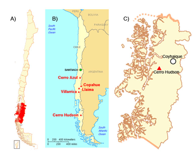 |
Figure 8. Map of Chile (a), the Aysén region in red (b), and a detail marking the region's capital, Coyhaique, and Cerro Hudson (c). Original image courtesy of Wikipedia. |
According to the Southern Andes Volcanological Observatory-National Geology and Mining Service (OVDAS-SERNAGEOMIN), seismicity increased during 25-26 October 2011. On 25 October, an M 4.6 volcano-tectonic earthquake occurred at a depth of 19 km, followed by a seismic swarm. More than 100 events, with depths ranging from 15 to 25 km, were recorded through the next day; twelve were M 3, and three were M 4. Most of the earthquakes were volcano-tectonic events with magnitudes below 3.6 and located W of the caldera at depths between 3 and 25 km. The earthquake hypocenters became shallower over time. OVDAS-SERNAGEOMIN did not detect any explosive event or episodes of high intensity harmonic tremor (as reported on 28 October).
During a 24-hour period beginning at 1600 on 27 October, an average of one earthquake per hour was recorded. Most were long-period with magnitudes less than 2.2. On 27 October, an M 3.6 VT earthquake occurred on the SW edge of the crater.
On 26 and 27 October, OVDAS-SERNAGEOMIN and local authorities flew over the caldera and observed three new craters along the SSE edge of the caldera, with approximate diameters of 200, 300, and 500 m. Mostly white plumes rose above the two smaller craters. The largest, southern-most crater emitted a plume with more ash that rose more than 5 km above the crater. Satellite imagery showed a plume drifting 12 km SE. The scientists also observed lahars in the Huemules river, to the W. In response, OVDAS-SERNAGEOMIN raised the Alert Level to 5 (Red), the highest level. According to the Oficina Nacional de Emergencia - Ministerio del Interior (ONEMI), 140 people were evacuated from areas within a 45-km radius of the volcano, defined as a high-risk zone. The hazard lay not only with earthquakes and eruption, but also with the possibility of flooding resulting from to glacier melt.
During another overflight on 28 October scientists observed a gas plume with a very low ash content rising 3-4 km above the craters. Seismicity continued to decrease during 28-29 October. Plumes were observed on 29 October (figure 9). Scientists conducting an overflight noted that one ash plume rose 1 km above the craters and drifted 5-8 km NE. They also confirmed that a large lahar descended the volcano and flowed into the drainage system including the Huemules river during the initial phase of the eruption. During another observation flight on 30 October, scientists saw ash plumes rising 0.8 km from two of the three craters.
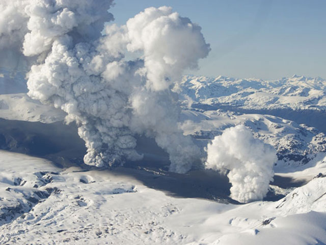 |
Figure 9. The three vents at Cerro Hudson observed on 29 October 2011. Dark gray ash can be seen at the base of at least one vent. Courtesy of, and copyrighted by, El Mercurio and SERNAGEOMIN, Chile. |
On 31 October, scientists observed gas plumes rising 0.5 km above the craters and drifting SE. Around 31 October, they also noted subsequent minor explosions and ash emissions. On 1 November, scientists observed an explosion and an accompanying ash plume that rose 1.5 km above the active craters.
On 2 November, OVDAS-SERNAGEOMIN reported that the Alert Level for Cerro Hudson had been lowered to 4 (Yellow), noting that the eruption that began on 26 October had ceased. ONEMI reported that the 140 evacuees were permitted to return home. Analysis of ash deposited on the edge of the crater during the eruption indicated the presence of juvenile basalt. During 1-6 November between 16 and 110 earthquakes per day were recorded, and satellite images showed drifting plumes daily.
According to OVDAS-SERNAGEOMIN, satellite imagery and an area web camera showed no plumes during 7-15 November. Seismic activity decreased significantly, reaching no more than four earthquakes per hour.
The NASA Earth Observatory photographed Cerro Hudson on 17 November 2011 (figure 10) and weeks later (figure 11).
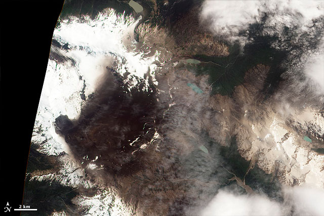 |
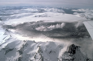
Figure 10. Image of Cerro Hudson taken in natural color on 17 November 2011 by the Advanced Land Imager (ALI) on NASA's Earth Observing-1 (EO-1) satellite. The image shows extensive fresh ash on the snowy surface. The apparent vent rests on the image's left-center, at the apex of the darkest funnel-shaped area. Courtesy of NASA Earth Observatory (Image by Jesse Allen; caption by Michon Scott). |
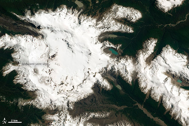 |
Figure 11. This post-eruptive image of Cerro Hudson, taken two weeks after figure 10, shows the volcano covered with snow. The label "apparent vent site" sits directly above the oval shaped vent site, a spot at left located below the gap between the words "apparent" and "vent" (also see previous figure). Courtesy of NASA Earth Observatory. |
Geological Summary. The ice-filled, 10-km-wide caldera of Cerro Hudson volcano was not recognized until its first 20th-century eruption in 1971. It is the southernmost volcano in the Chilean Andes, related to subduction of the Nazca plate beneath the South American plate. The massive volcano covers an area of 300 km2. The compound caldera is drained through a breach on its NW rim, which has been the source of mudflows down the Río de Los Huemeles. Two cinder cones occur N of the volcano and others occupy the SW and SE flanks. This volcano has been the source of several major Holocene explosive eruptions. An eruption about 6,700 years ago was one of the largest known in the southern Andes during the Holocene; another eruption about 3,600 years ago also produced more than 10 km3 of tephra. An eruption in 1991 formed a new 800-m-wide crater in the SW portion of the caldera.
Information Contacts: SERNAGEOMIN (Southern Andes Volcanological Observatory-National Geology and Mining Service), Avda Sta María No. 0104, Santiago, Chile (URL: http://www.sernageomin.cl/); NASA Earth Observatory, EOS Project Science Office, NASA Goddard Space Flight Center, Goddard, Maryland, USA (URL: http://earthobservatory.nasa.gov/); Oficina Nacional de Emergencia - Ministerio del Interior (ONEMI), Beaucheff 1637 / 1671, Santiago, Chile (URL: http://www.onemi.cl/); and El Mercurio (URL: http://www.elmercurio.cl/).