Report on Paluweh (Indonesia) — January 2014
Bulletin of the Global Volcanism Network, vol. 39, no. 1 (January 2014)
Managing Editor: Richard Wunderman.
Paluweh (Indonesia) August 2013 pyroclastic flows took lives; dome growth stopped late 2013
Please cite this report as:
Global Volcanism Program, 2014. Report on Paluweh (Indonesia) (Wunderman, R., ed.). Bulletin of the Global Volcanism Network, 39:1. Smithsonian Institution. https://doi.org/10.5479/si.GVP.BGVN201401-264150
Paluweh
Indonesia
8.32°S, 121.708°E; summit elev. 875 m
All times are local (unless otherwise noted)
This report discusses the time interval from April 2009 to early 2014, during which time Paluweh (also known as Mount Rokatenda) had vigorous explosive activity in late 2012 with dome emplacement [noted in early] October 2012. A 3 February 2013 ash plume rose to over 13 km in altitude and drifted 325-590 km SE, S, and SW. By 7 February, portions of the growing dome's S flank detached. On 10 August 2013 a pyroclastic flow killed at least 5 people on the island's N shore. The dome remained unchanged during September 2013 through at least March 2014.
Table 2 summarizes key data describing Paluweh from 17 June 2011 to 8 April 2014. In addition, Volcano Discovery showed photos attributed to local resident Ignatius Cua. They noted that Cua "reported that a small zone of dead vegetation associated with new fumarolic activity had developed in the summit region in June 2012. It appears that lava extrusion commenced at or near this zone in mid-October, marking the beginning of the 2012 eruption."
Table 2. Summary of activity recorded for Paluweh from 17 June 2011 through 8 April 2014. The information was compiled from the Indonesian Center for Volcanology and Geologic Hazard Mitigation (CVGHM) and the Darwin Volcanic Ash Advisory Centre (VAAC).
| Date Range | Darwin VAAC | CVGHM |
| Jan 2011-Jun 2011 | -- | In their 20 June 2011 report, CVGHM said that tremor had been absent since 1 March 2010 and during January 2011-June 2011, they did not see solfatara emissions from the summit. On 17 June 2011, the Alert Level was lowered to 1 (on a scale of 1-4). |
| 18 Jan 2012 | -- | In their 25 January report, they noted that on 18 January 2012 there were 60 shallow volcanic earthquakes. Fog prevented visual observations. |
| 8-13 Oct 2012 | -- | On 8 October 2012, the Alert rose from I to II; on 13 October 2012, it rose from II to III. Later reports noted dome growth had begun (see text). |
| 11-13 Nov 2012 | Ash plume to 4 km altitude drifting 90-150 km NW and W. | -- |
| 14-19 Nov 2012 | Ash plume to 2.4-3 km altitude drifting 45-150 km NW and W. | -- |
| 21 and 23-27 Nov 2012 | Ash plume to 2.4-3 km altitude drifting 35-115 km WNW, W, and SW. | -- |
| 28 Nov-4 Dec 2012 | Ash plume to 1.5-2.4 km altitude drifting 35-65 NW and W. | See text |
| 6 and 8 Dec 2012 | Ash plume to 3.7 km altitude drifting 35-75 km NW, W, and SW. | -- |
| 14-15 Dec 2012 | Ash plume to 3 km altitude drifting 35-65 km NW and W. | -- |
| 17 Dec 2012 | Ash plume to 1.5 km altitude drifting 55 km E. | -- |
| 18 Dec 2012 | Ash plume to 3.4-3.7 km altitude drifting 55 km E. | -- |
| 19 and 21-23 Dec 2012 | Ash plume to 2.4-2.7 altitude drifting 55-75 km E, SW, W, and NW. | -- |
| 4 Jan 2013 | Ash plume to 3.7 km altitude drifting 37 km NE. | -- |
| 7 Jan 2013 | Ash plume to 3 km altitude drifting less than 20 km NE. | -- |
| Early Jan 2013 | -- | By 13 Jan 2013 there had been 5.1 x 10⁶ m3 of dome loss. |
| 29 Jan. 2013 | Ash plume to 1.8 km altitude drifting less than 20 km ENE. | -- |
| 03 Feb 2013 | Ash plume to 13.1-13.7 km altitude drifting 325-590 km SE, S, and SW. | 1-3 Feb. 2013. Pyroclastic flows and ashfall. |
| 4 Feb 2013 | Ash plumes to 7.6 km altitude. | -- |
| Early Feb 2013 | -- | By 7 Feb 2013 substantial parts of the S flank of the lava dome had been removed. |
| 8-12 Feb 2013 | Ash plume to 2.1-3.7 km altitude drifting 35-110 km NW, NNW, and N. | -- |
| 17-18 Feb 2013 | Ash plume to 7 km altitude drifting E and NE. | See text. |
| 9-12 Mar 2013 | Ash plume to 2.4 km altitude drifting 25-75 km E and NW. | -- |
| 13, 17-19 Mar 2013 | Ash plume to 2.4 km altitude drifting 35-95 km E, W, and WNW. | -- |
| 19-21 and 24-26 Mar | Ash plume to 3 km altitude drifting 55-335 km SW, WSW, W, NW, and NE. | -- |
| 27 Mar-1 Apr 2013 | Ash plume to 2.4-3.7 altitude drifting 45-100 N, NE, and E. | -- |
| 16 Apr 2013 | An ash plume to 2.1 km drifting 37 km E. | -- |
| 20 Apr 2013 | Ash plume to 2.1 km drifting 45 NW. | -- |
| 29-30 Apr 2013 | Ash plume to 2.1-3 km altitude drifting 35-110 km NW and W. | -- |
| 4-5 May 2013 | Ash plume to 2.1 km altitude drifting 45-55 km SW and W. | -- |
| 13 May 2013 | Ash plume to 2.1 km altitude drifting over 90 km WNW and NW. | -- |
| 21-22 and 24 May 2013 | Ash plume to 2.1-3 km altitude drifting 25-55 km NW, W, and E. | -- |
| 19 Jun 2013 | Ash plume to 2.4 km altitude drifting over 35 km. | -- |
| 10-13 Aug 2013 | Ash plume to 4.3 km altitude drifting 130 km W. | [Major pyroclastic flows on 10 August resulted in fatalities (see text for details).] |
| January-5 Apr 2014 | -- | Activity mainly consisted of white and gray fumarolic plumes rising at most 100 m above the lava dome and drifting W, N, and E. During September 2013 to March 2014, the lava dome remained static. |
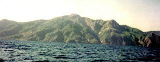
A photo of the dome taken in 2012 appears in figure 1. CVGHM reported that activity at Paluweh during October 2012-January 2013 was characterized by lava-dome growth and incandescent avalanches, pyroclastic flows, and ash plumes rising as high as 4 km above the dome. Ejected material was deposited 3 km away. The whole island was affected by ashfall, which was an average of 2 cm thick on some areas. Some infrastructure and several homes were damaged by ash and lahars.
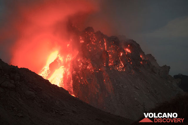 |
Figure 1. The unstable lava dome at Paluweh seen behind the older dome (the dark slope in the foreground in a night photo). Just prior to the photo, a large block broke off the dome's left side (upper E flank). In the aftermath, seen here, molten material gushed from the dome's interior. Photo is from December 2012. The portion of the dome seen here is on the order of 100-150 m high (from the dark basal region at right to the top. Photo courtesy of Tom Pfeiffer, Volcano Discovery. |
The Darwin Volcanic Ash Advisory Centre (VAAC) reported a 3 February 2013 eruption that was outstanding in terms of altitude of the ash plume's top and the lateral distance the plume was visible in satellite imagery. The plume rose to 13.1-13.7 km and drifted 325-590 km SE, S, and SW. Eruptions around this time were also noted by news articles, some of which mentioned ashfall.
The Darwin VAAC tracked the number of volcanic ash advisories for Paluweh in comparison to 14 other volcanoes during the interval January through November 2013 (figure 2). They issued 230 VAAs for Paluweh, the second highest number for any one of the 14 volcanoes they discussed during this interval. Figure 3 shows the extent of plumes as delineated in VAAs for the same interval. As further background, figure 4 shows that during the interval 1 July 2008 through 30 June 2014 the Darwin VAAC issued approximately 800 to 1500 VAAs each year. Those advisories have bearing on delays on air travel and transport as well as on plume-derived impacts to the atmosphere.
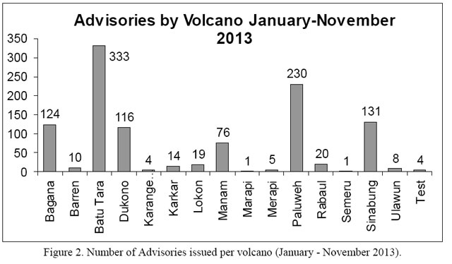 |
Figure 2. A histogram showing volcanoes reported by the Darwin VAAC during an 11-month period January 2013 to November 2013. In that interval, Paluweh was the subject of 230 VAAs - the second largest number or 21% of the total 1,092 VAAs on eruptions during the same interval. The 4 cases labeled 'Test' were issued in order to check the operational functionality of the system and were excluded from the total. Courtesy of the Darwin VAAC (see ICAO, 2014). |
 |
Figure 3. A graphical summary of Darwin VAAC's reports (VAAs) issued during period January 2013 to November 2013 showing the boundaries of airspace containing ash plumes (red to red-brown polygons). Paluweh is the southernmost volcano shown and the source of the large plumes, with some restricted to the Lesser Sunda Islands and others approaching and lapping over NW Australia. Batu Tara volcano, which is adjacent and NW of Paluweh, was the source of more VAA reports than Paluweh but most of the plumes were comparatively restricted during this time interval. Courtesy of the Darwin VAAC (see ICAO, 2014). |
 |
Figure 4. Number of VAAs issued by Darwin VAAC during July 1993 to 12 since 1 July 1993 to December 2014. Note that the Australian fiscal year runs from 1 July to 30 June. Courtesy of the Darwin VAAC (see ICAO, 2014). |
Figure 5 shows a Paluweh plume on 10 August 2013 courtesy of the Darwin VAAC. The VAAC reported that during 11-12 August 2013 Paluweh's ash plumes rose to an altitude of 1.8 km and drifted 110-130 km W. A news article noted that the eruptions were smaller on 12 August 2013, but pyroclastic flows continued to be observed. The Alert Level remained at 3 (on a scale of 0-4).
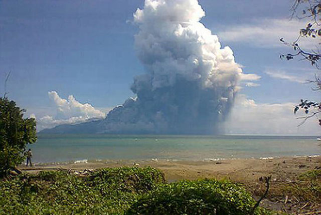 |
Figure 5. A photo taken looking N from the Maurole district of East Nusa Tenggara province with a camera phone; it shows Paluweh emitting an inclined column of hot ash on 10 August 2013. Photo courtesy of Agence France Presse/Scantix. |
Dome collapse animation. A Volcano Discovery team observed Paluweh during 30 November-2 December 2012 and captured some images that can help authorities explain the processes and attendant hazards associated with unstable growing domes (figure 6). Richard Roscoe (Photovolcanica) made the source animation from a few shaky handheld photos of a dome lobe collapse during daylight on unstated date during his visit. These images were taken from a similar perspective as figure 1. He estimated the entire new dome as on the order of 200 m (at most) from base to top. He thought that the size of collapse (in the red circle on figure 6 (b)) as "maybe about 10-20 m high." Regarding the termination of the collapse event, he stated that the material travelling off-frame hit the base of the old dome and then stopped abruptly as it encountered the old dome's wall (the far side of the sloping ridge in the foreground).
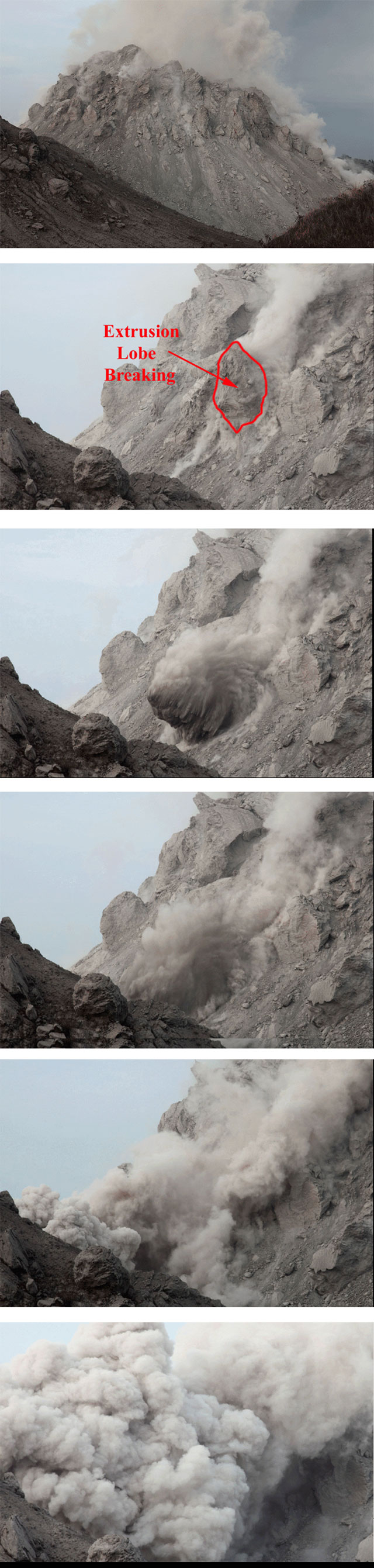 |
Figure 6. Dome instability generating a small pyroclastic flow at Paluweh. Images b-f are screen captures from from an animation made using hand-held photos by Richard Roscoe. (a) The larger dome is seen and the yellow box shows the area of the other frames. (b) The area in red delineates the part of the dome's surface that later collapsed, an area described as a small extrusion lobe (see text). Successive photos came from later parts of the animation. Courtesy of Richard Roscoe (Photovolcanica), used with permission. |
Volcano Discovery reported that Paluweh's lava dome seemed to be visibly growing on all sides, with almost constant incandescent rockfalls in multiple areas. The new dome, called Rerombola lava dome, was ~150 m high, the highest point on the island, and the basal diameter was 200-250 m. During their stay, a vent on the upper E part of the dome ejected ash for periods of several hours and produced jet-like degassing sounds. A steam-and-ash plume rose several kilometers. At the base of the dome, hot blocks had ignited local vegetation.
February 2013 has largest plumes of the reporting interval. According to CVGHM, on 1 February 2013 at 1652 an eruption generated an ash plume that rose 2 km. Pyroclastic flows and avalanches were observed. On 2 February an explosion produced an ash plume that rose 4 km and was accompanied by booms and rumbling. The ash plume drifted S and deposited ash up to 1 mm thick in East Nusa Tenggara island (Ende, 60 km S); ash was also reported in Ona (SE part of the island) and thin deposits were reported in other areas of the island to the W, N, and E. Significant portions of the S dome were lost. Prior to this, on 13 January 2013, the lava-dome volume was an estimated 5.1 million cubic meters.
Based on analyses of satellite imagery, wind data, and pilot reports, the Darwin VAAC reported that on 3 February 2013 ash plumes from Paluweh rose to altitudes of 13.1-13.7 km a.s.l. and drifted 325-590 km SE, S, and SW. The next day ash plumes at an altitude of 7.6 km a.s.l. were observed. As a result of the eruption the whole island was affected by ashfall, which was an average of 2 cm thick in some areas. Some infrastructure and several homes were damaged by ash and lahars.
Beyond Indonesia, the ash plumes from the 3 February eruption caused significant impacts. They caused a series of flight delays and related impacts on the tourist and aviation industries as they advanced towards and eventually came over the Kimberley coast in Western Australia (larger polygons on figure 3).
During 4-10 February diffuse white plumes rose 50-100 m. The Alert Level remained at 3 (on a scale of 1-4), and visitors and residents were prohibited from approaching the crater within a 3-km-radius.
Landsat visible and thermal data. A NASA Earth Observatory report posted online showed images of Paluweh from 29 April 2013. A visible wavelength image from the Landsat Data Continuity Mission's Operational Land Imager instrument shows an ash plume drifting ~50 km NE of the volcanic island. A thermal infrared image from the same satellite showed a small hot spot surrounded by cooler dark ash clouds.
Deadly 10 August 2013 pyroclastic flows. As activity persisted in the ~10 months prior to the 10 August eruption, authorities repeatedly tried to persuade residents to relocate to safer areas. Although reports regarding evacuations are variable, the Indonesian National Board for Disaster Management (BNPB) reports that about a quarter of the island's total residents had been permanently moved to nearby Flores Island since the onset of activity in October 2012. Thus, of 10,858 total island residents, about 2,700 had moved. After the 10 August eruption, the BNPB source said that at least another 1,203 had moved by 30 August.
News sources also indicated that around the time of the pyroclastic flows, a volcanologist at the monitoring post for Paluweh noted that the deadly phase of the 10 August 2013 eruption lasted 4-7 minutes. Pyroclastic flows burned trees around the beach and villages, making it difficult to reach victims. BBC News Asia report on 10 August stated six dead, four adults and two children. Regarding timing of the eruption, they quoted a CVGHM source: "Mr Surono said the latest eruption had begun at 04:27 on Saturday [10 August] (20:27 GMT Friday [9 August]) and lasted for nearly four hours." Official sources also indicated that pyroclastic flows continued hours after the initial eruption.
The Jakarta Post article gave the death toll as at least five. It stated the specific location of the deaths as "Woje Wubi to Punge beach in Rokirole village."
According to news sources, after the 10 August eruption a rescue team was sent to evacuate about 2,000 people that remained inside the 3-km exclusion zone. The news reports said that a team member described rescuing people as difficult because they were reluctant to leave their livestock and homes, but also that the ground was hot and covered in 10-20 cm of ash.
Tempo.co news issued a report in Indonesian saying that a total of 12 residents began to be evacuated from the town of Maumere, the capital of the district, as a result of the 10 August eruption. This source indicated six fatalities. It said that two motorboats had successfully evacuated hundreds of residents of four villages.
Based on analyses of satellite imagery and wind data, the VAAC reported during 10 to 13 August 2013 that an ash plume rose to an altitude of 4.3 km and drifted 130 km W.
The summit crater opens to the S and large-scale production of crops (plantation agriculture) extends almost to the volcano's peak. This southerly path is typically followed by pyroclastic flows from the dome. In contrast, the 10 August pyroclastic flow traveled down the N flank of the volcano, descending into beachside villages.
Reference: International Civil Aviation Organization (ICAO), 2014, The Twelfth Meeting Of Asia/Pacific Robex Working Group (Robex Wg/12) and Fourth Meeting Of Meteorological Hazards Task Force (MET/H TF/4), ROBEX WG/12 / MET/H TF/4 - IP/C2, 2014, Agenda Item (conjoint session; 2d; 11/03/14); ICAO Regional Sub-Office, Beijing, China 19 March 2014, ICAO, 18 pp. [URL: http://www.icao.int/APAC/Meetings/2014 METHTF4/IP-C2_ICAO_AI.C2d - Darwin VAAC Report - AUS.pdf].
Geological Summary. Paluweh volcano, also known as Rokatenda, forms the 8-km-wide island of Palu'e north of the volcanic arc that cuts across Flores Island. The broad irregular summit region contains overlapping craters up to 900 m wide and several lava domes. Several flank vents occur along a NW-trending fissure. The largest historical eruption occurred in 1928, when strong explosive activity was accompanied by landslide-induced tsunamis and lava dome emplacement. Pyroclastic flows in August 2013 resulted in fatalities.
Information Contacts: BNPB (the Indonesian National Board for Disaster Management) [Informasi Penanggulangan Bencana Terkini di Indonesia], Gedung Graha 55 Jl. Tanah Abang II No. 57, Jakarta, Indonesia (URL: http://www.bnpb.go.id/); Center of Volcanology and Geological Hazard Mitigation (CVGHM), Jalan Diponegoro 57, Bandung 40122, Indonesia (URL: http://www.vsi.esdm.go.id/); Darwin Volcanic Ash Advisory Centre (VAAC), Bureau of Meteorology, Northern Territory Regional Office, PO Box 40050, Casuarina, NT 0811, Australia (URL: http://www.bom.gov.au/info/vaac/); NASA Earth Observatory, EOS Project Science Office, NASA Goddard Space Flight Center, Goddard, Maryland, USA (URL: http://earthobservatory.nasa.gov/); Volcano Discovery (URL: http://www.volcanodiscovery.com/); and Richard Roscoe, Photovolcanica (URL: http://www.photovolcanica.com/).