Report on Galeras (Colombia) — January 2014

Bulletin of the Global Volcanism Network, vol. 39, no. 1 (January 2014)
Managing Editor: Richard Wunderman.
Edited by Julie A. Herrick.
Galeras (Colombia) Continued ash emissions and seismicity during April-December 2013
Please cite this report as:
Global Volcanism Program, 2014. Report on Galeras (Colombia) (Herrick, J.A., and Wunderman, R., eds.). Bulletin of the Global Volcanism Network, 39:1. Smithsonian Institution. https://doi.org/10.5479/si.GVP.BGVN201401-351080
Galeras
Colombia
1.22°N, 77.37°W; summit elev. 4276 m
All times are local (unless otherwise noted)
Ash plumes and elevated seismicity continued to occur at Galeras during April-December 2013 (figures 128 and 129). Monitoring efforts based in Pasto, Colombia, were led by the Servicio Geológico Colombiano (SGC). SGC maintained Alert Level III (Yellow; "changes in the behavior of volcanic activity") during this reporting period.
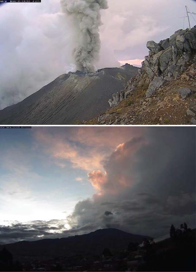 |
Figure 128. Two webcameras simultaneously captured an ash plume rising from Galeras on 13 December 2013. The top photo was acquired by the Bruma webcam, located on the SW rim of the crater; the bottom photo was taken from the observatory located in Pasto (~10 km E of the summit). Courtesy of SGC. |
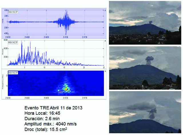 |
Figure 129. SGC correlated tremor from Galeras with an explosion of ash on 11 April 2013. (Left) A tremor signal was detected at 1645 with a duration of 2.6 minutes. (Right) The video camera located at the observatory in Pasto captured an impulsive ash plume. Each image has an increased optical zoom focused on the summit; the look direction is approximately W. Courtesy of SGC. |
SGC maintained a wide monitoring network for Galeras that included geophysical, geochemical, meteorological, and optical instrumentation. Seismic monitoring consisted of broadband, short-period, and acoustic instruments with 12-15 instruments total operating during April-December 2013. Additional geophysical instruments included electronic tiltmeters, telemetered GPS stations, electromagnetic stations, and a network of geophones for flood detection and early warning. Gas monitoring efforts included telemetered ScanDOAS stations and also stations dedicated to diffuse radon emissions. Other permanent stations around the volcanic edifice included anemometers and webcameras. Monthly technical reports frequently highlighted geochemical analysis of local hotsprings. In this report, we highlight seismicity, gas monitoring, and ash plumes that have been correlated with earthquakes, particularly tremor.
Seismicity. During this reporting period, seismicity from Galeras was typically dominated by tremor (table 13). Tremor events became less numerous toward the end of the year, although total duration remained high (an average of 6 hours per month). Seismic swarms were only detected on four different days in April, May, and October 2013 (table 14). A swarm that started on 22 May at 1916 consisted of 129 long-period (LP) earthquakes, and was followed by 11 minutes of tremor. SGC noted that ash emissions were likely associated with the activity. Two acoustic signals were also detected that day, at 2239 and 2315.
Table 13. Seismicity at Galeras during April-December 2013. Earthquake counts are for four types of events: volcano-tectonic (VT), long-period (LP), tremor (TRE) expressed both in terms of # of events and duration, and hybrid (HYB); events labeled "Unclassified" were described by SGC as earthquakes that did not correspond to the current categories. Tornillos did not occur during this reporting period. Courtesy of SGC.
| Month | VT | LP | TRE | HYB | Total Duration of Tremor | Range ML (VT) | Depths (km) | Hypocenters Located | Unclassified |
| Apr 2013 | 12 | 116 | 234 | 13 | 14 hours | -0.2-2.7 | 5-14 | 42 | 2016 |
| May 2013 | 19 | 60 | 111 | 16 | 8 hours | less than 2.6 | 1-15 | 56 | 1804 |
| Jun 2013 | 17 | 45 | 55 | 2 | 4 hours | -0.1-2.2 | 2-12 | 47 | 907 |
| Jul 2013 | 33 | 38 | 41 | 6 | 2 hours | less than 3.2 | 1-21 | 59 | 745 |
| Aug 2013 | 21 | 30 | 76 | 3 | 5 hours | 0.2-1.3 | 1.5-7.5 | 22 | 1082 |
| Sep 2013 | 6 | 13 | 72 | 0 | 4.5 hours | less than 1.3 | 1.5-7.5 | 20 | 748 |
| Oct 2013 | 56 | 21 | 103 | 4 | 8 hours | -0.4-3.8 | 0-13 | 109 | 1383 |
| Nov 2013 | 35 | 10 | 146 | 8 | 6 hours | less than 3.9 | 1-12 | 66 | 1286 |
| Dec 2013 | 18 | 12 | 86 | 9 | 5.5 hours | 0-1.7 | 1-11 | 36 | 962 |
Table 14. Seismic swarms from Galeras were rare events, occurring on four different days during this reporting period of April-December 2013. Courtesy of the SGC.
| Date | Time | Earthquakes |
| 25 Apr 2013 | 0943, 1120 | 101 |
| 22 May 2013 | 1916 | 129 |
| 4-5 Oct 2013 | -- | -- |
In April 2013, one earthquake was felt in the town of Pasto. At 0532 on 2 April, an M 2.7 VT earthquake was recorded, located 12.8 km NE of the crater. An M 2.2 earthquake that occurred at 1158 on 7 June was reported by local populations in Pasto. This earthquake was located 9 km NE of the crater at a depth of 10 km with respect to the summit. Three earthquakes were detected in July and felt by residents of Pasto; they occurred on 24 (M 3.2 and 2.5) and 29 (M 2.9) July with depths of 5 and 11 km. The earthquakes on 24 July were located ~5.5 km SE of the crater; the event on 29 July was located 21 km NE of Galeras. An M 3.8 earthquake occurred at 1713 on 15 October; this earthquake was felt by residents within different sectors of Pasto as well as the municipalities of Nariño and La Florida. The earthquake was located 7 km NE of Galeras with a depth of 5.5 km. In November, one earthquake was felt by local populations in the San Ignacio sector of Pasto as well as other sectors of Nariño. This M 3.9 earthquake occurred at 1236 on 10 November with a depth of 9 km and was located 4.5 km NE of Galeras.
Gas monitoring. During this reporting period, minor amounts of ash occasionally accompanied gas emissions typically rising from the N and W sectors of the volcano, and dispersed. As a part of an ongoing international monitoring project, the Network for Observation of Volcanic and Atmospheric Change (NOVAC), SGC maintained ScanDOAS instruments at three different locations NW of the edifice (see the instrumentation map in Bulletin 37:04, figure 116). During April-December SO2 flux rarely exceeded 1,000 tons/day. The maximum value, considered relatively high for Galeras, was 1,475 tons/day and recorded on 29 September 2013.
Geological Summary. Galeras, a stratovolcano with a large breached caldera located immediately west of the city of Pasto, is one of Colombia's most frequently active volcanoes. The dominantly andesitic complex has been active for more than 1 million years, and two major caldera collapse eruptions took place during the late Pleistocene. Long-term extensive hydrothermal alteration has contributed to large-scale edifice collapse on at least three occasions, producing debris avalanches that swept to the west and left a large open caldera inside which the modern cone has been constructed. Major explosive eruptions since the mid-Holocene have produced widespread tephra deposits and pyroclastic flows that swept all but the southern flanks. A central cone slightly lower than the caldera rim has been the site of numerous small-to-moderate eruptions since the time of the Spanish conquistadors.
Information Contacts: Servicio Geológico Colombiano (SGC), Observatorio Vulcanológico y Sismológico de Pasto, Pasto, Colombia (URL: https://www2.sgc.gov.co/volcanes/index.html).