Report on Nyamulagira (DR Congo) — March 2014

Bulletin of the Global Volcanism Network, vol. 39, no. 3 (March 2014)
Managing Editor: Richard Wunderman.
Edited by Jen Fela.
Nyamulagira (DR Congo) Eruption during 6 November 2011 into early 2012; pit crater morphology changes
Please cite this report as:
Global Volcanism Program, 2014. Report on Nyamulagira (DR Congo) (Fela, J., and Wunderman, R., eds.). Bulletin of the Global Volcanism Network, 39:3. Smithsonian Institution. https://doi.org/10.5479/si.GVP.BGVN201403-223020
Nyamulagira
DR Congo
1.408°S, 29.2°E; summit elev. 3058 m
All times are local (unless otherwise noted)
Our last report (BGVN 35:08) described a flank eruption at Nyamuragira during 2-27 January 2010 that produced a new cone and 12-km-long lava flows. The final report of the GORISK Scientific Network (Kervyn and others, 2010) stated that this eruption ended by 27 January 2010. MODVOLC thermal alerts occurred regularly at Nyamuragira through 2 February 2010 and then ceased until early November 2011.
Nyamuragira began to erupt again on its flanks at 1755 on 6 November 2011, according to GORISK, after two days of unspecified "intense seismic activity." This report conveys information from a variety of sources credited below, but largely from Dario Tedesco and the GORISK Scientific Network. GORISK was an initiative of both the National Museum of Natural History (Luxembourg) and the Royal Museum for Central Africa (Belgium). GORISK inferred that the eruption lasted through April 2012 [but only noted degassing from a vent inside the pit crater after late February in their June 2012 eruption summary].
An early synopsis of the eruption that began on 6 November 2011 came from the Virunga National Park. The eruption was visible at Park headquarters. Park staff described the 6 November eruption as coming from a fissure on the volcano's NE flank. It produced slow-moving lava flows that advanced into unpopulated areas to the N. Park staff also took a video of fountaining at night. On 7 November the Park uploaded 39 seconds of their footage on Youtube. During the first week of the eruption the Park staff hiked through the bush, in places having to cut vegetation, crossing young forest and irregular lichen-covered volcanic topography on a 4 hour hike that enabled them to take a closer view.
The hikers described airfall scoria covering the landscape as they approached closer. Their log said that the "...eruption finally came into view, along with the roar of intensely spewing fire and lava, as well as lightning and thunder." The vent area was located 12 km ENE of the crater, close to one of the 1989 eruptive sites. The first fissure was oriented E-W, perpendicular to the rift, and emitted lava fountains up to 300 m high. The eruption site was described as a flat area cut by a 500- to 1,000-m-long fissure. Figure 40 shows a photo from around this time but a topographic high of new material had already grown. NASA Earth Observatory reported that lava flows had advanced as far as 11.5 km by 12 November 2011 (figure 41). On 12 November, the lava flow front was located 5 km from the Kelengera-Tongo road.
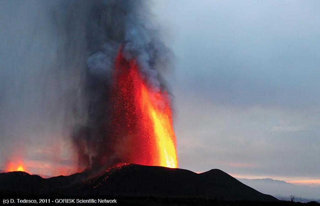 |
Figure 40. Lava fountaining at Nyamuragira during early November 2011. The venting fissure is also seen in the distance at left; tephra created the topographic high seen here, rising from a comparatively flat area. Exact date and look-direction unknown. Courtesy Dario Tedesco and the GORISK Scientific Network. |
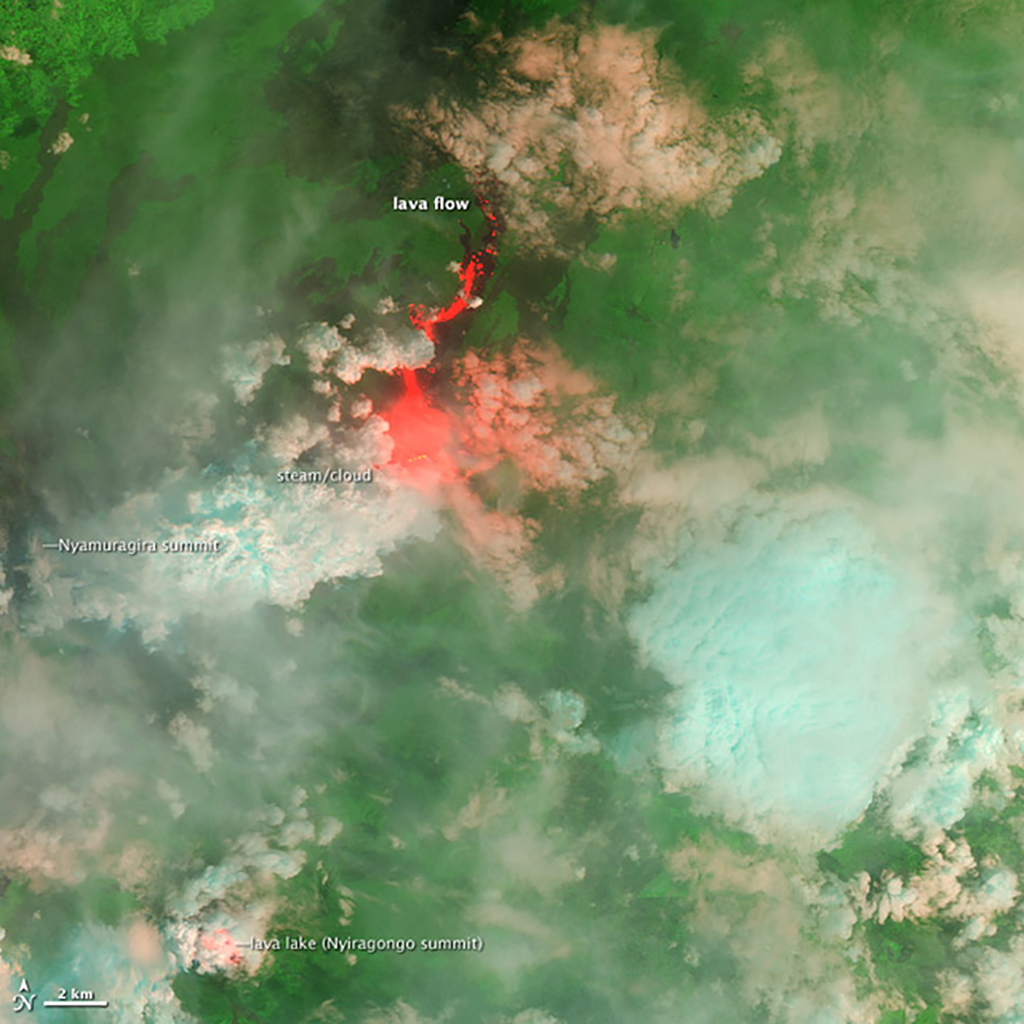 |
Figure 41. Satellite image of Nyamuragira on 15 November 2011 showing lava flowing away from the rift. The imager combines infrared and visible light; hot lava appears orange, and cooled lava appears black. Cooler clouds appear blue, and warm steam appears white and orange. Nyiragongo's lava lake is visible to the S. Image created by Jesse Allen, using EO-1 ALI data provided by the NASA EO-1 team. Courtesy NASA Earth Observatory. |
For about a month, the park allowed overnight treks to the eruption site. A video featured on Youtube by Piet Schutter contains footage taken on 12 November; some scenes are at close range (looking up towards the eruption). That video shows both daylight and night scenes, features sound, and has people in the foreground, which helps establish scale.
The GORISK Scientific Team reported that satellite radar (InSAR) images acquired on 11 November 2011 revealed major ground deformation features associated with the eruption. Preliminary estimation of the observed deformation signal suggested an affected area spreading over 250 km2. Pressure from the ascending magma caused the ground to rise more than 50 cm at the eruptive site where a spatter cone developed. Another 15 cm deformation was detected within the caldera, which was accompanied by deflation observed on the flanks.
An elongated spatter-and-scoria cone, referred to by scientists as the western cone and by locals as "Umoja," formed along the first fissure (figure 42). In early December 2011, a new cone formed on a new eruptive fracture to the E; this cone was referred to by scientists as the eastern cone and by locals as "Tuungane" (figure 42). During the next few days, the eruptive activity migrated to this new edifice. Satellite images acquired on 3 January 2012 showed fresh lava flowing to the NNE (figures 43 and 44).
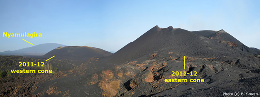 |
Figure 42. Panoramic view of Nyamuragira and the two new cones of the November 2011-April 2012 eruption. Date of photo unknown (sometime between November 2011 and early June 2012). Photo courtesy Benoit Smets, GORISK Scientific Network. |
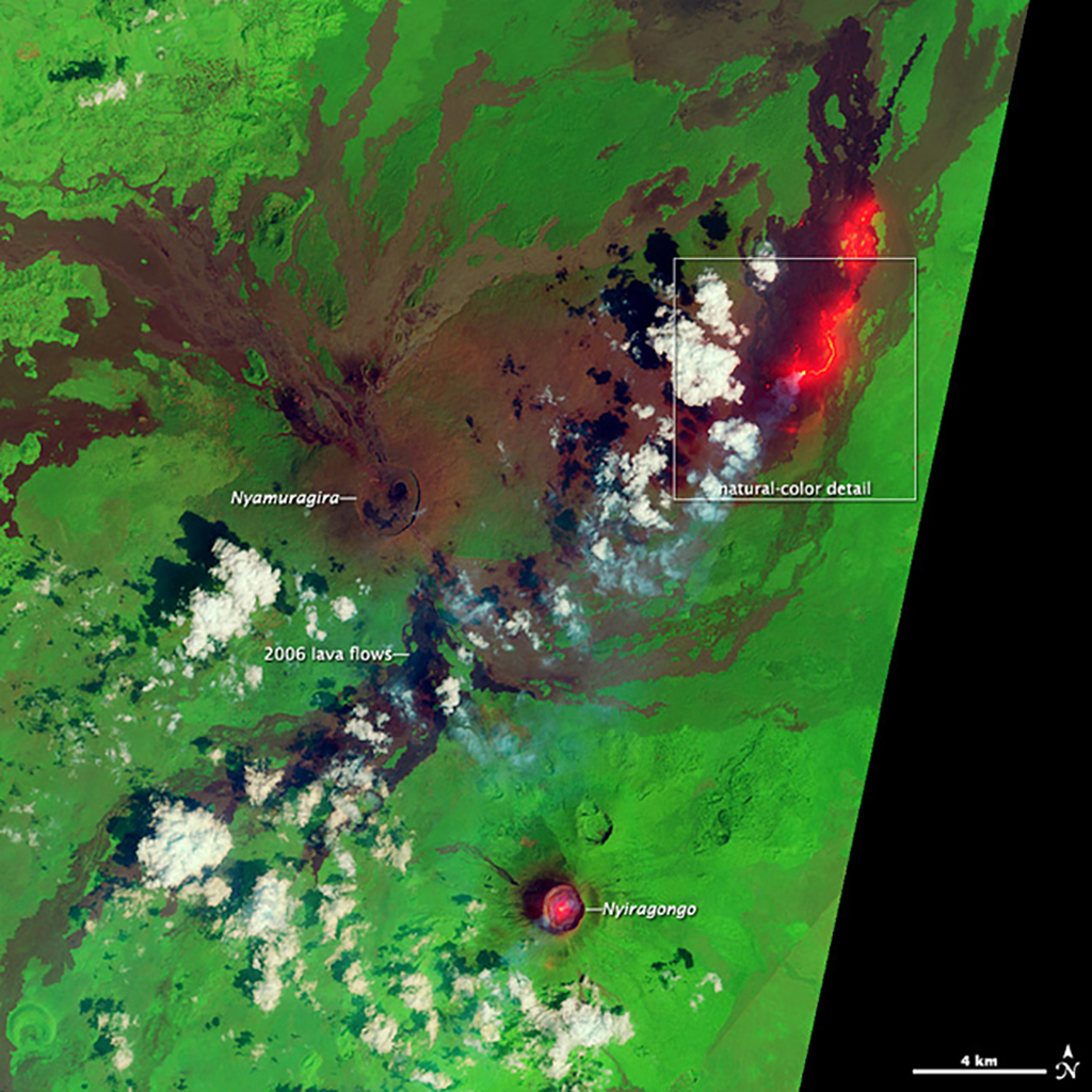 |
Figure 43. False-color satellite image of Nyamuragira on 3 January 2012. The hot active lava was detected in shortwave and near-infrared light (bright red-orange). Nyiragongo's crater lava lake is visible to the S. Image acquired by the Advanced Land Imager (ALI) aboard the Earth Observing-1 (EO-1) satellite. Courtesy Jesse Allen, Robert Simmon, and EO-1 Team, NASA Earth Observatory. |
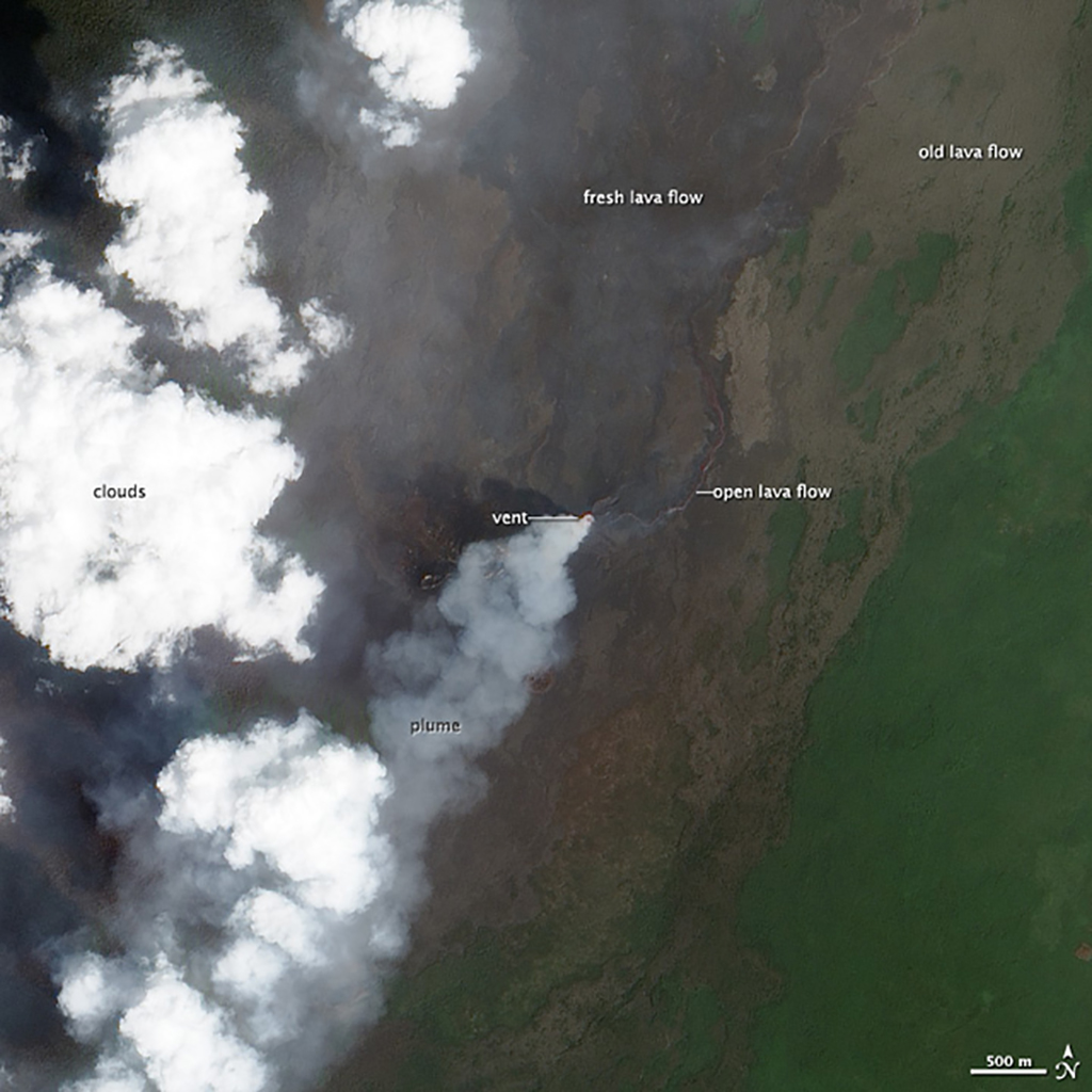 |
Figure 44. Natural-color satellite image of Nyamuragira on 3 January 2012 showing close-up of outlined area in figure 43. Active lava is visible flowing N-NE, with older flows also visible to the N and NE. A sulfur-dioxide-rich plume extends to the SW from the central vent. Undisturbed vegetation is also visible. Image acquired by the Advanced Land Imager (ALI) aboard the Earth Observing-1 (EO-1) satellite. Courtesy Jesse Allen, Robert Simmon, and EO-1 Team, NASA Earth Observatory. |
According to visiting scientists from the Afar Consortium Project, activity continued on 8 January 2012. The initial scoria cone appeared inactive and a second formed to the N of the first; both cones were about 300 m high. The second cone was extremely active for the duration of the observations (about 15 hours) with fountains over twice the height of the cone; lava flowed N. The observers, about 1.5 km away, felt the heat from the eruption and noted lapilli fall.
A group from Volcano Discovery observed the ongoing fissure eruption during 22-25 January 2012 from the newly formed cinder cones near the fissure. They reported three coalescent cones, the largest containing a small lava lake. The lake ejected spatter every few seconds, rising as high as 200 m above the summit. Some bombs reached the base of the cone. Lava flows from the vent extended several kilometers N. Numerous small breakouts formed secondary flows, and a large breakout ~2 km N of the cone fed a large lava flow ~20 m wide. Burning forests were reported to the NNE.
Preliminary estimates by GORISK for the 2011-2012 eruption indicated a volume of emitted lavas of at least 81.5 x 10⁶ m3. The lava flows did not reach inhabited areas and only affected vegetation in Virunga National Park. The 2011-2012 eruption was the biggest event at Nyamuragira since the 1991-1993 eruption, which lasted nearly 1.5 years and emitted an estimated ~131 x 106 m3 of lava (Smets and others, 2010).
A report by Dario Tedesco stated that in March 2012, a series of explosion earthquakes were recorded by the seismic network of the Goma Volcano Observatory. Following this activity, the fissure eruptions suddenly stopped. Also in March the morphology of the pit crater began to change (figures 45 and 46). Beginning in late February 2012 through at least June 2012, degassing occurred in the caldera. The emission site was located inside the pit crater, but degassing occurred from all fractures inside the caldera. On several occasions, meteorological conditions caused sulfur odors to reach the city of Goma (~30 km S from Nyamuragira's crater).
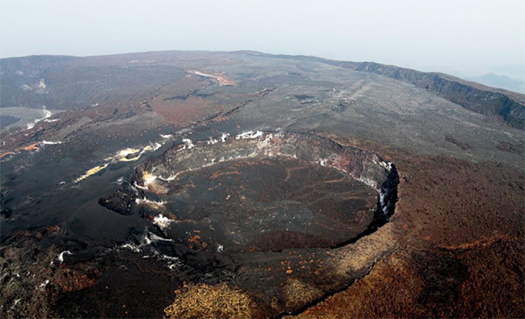 |
Figure 45. View of Nyamuragira's pit crater on 20 January 2012. Direction unknown. Courtesy Dario Tedesco, International Organization of Migrants and Second University of Naples. |
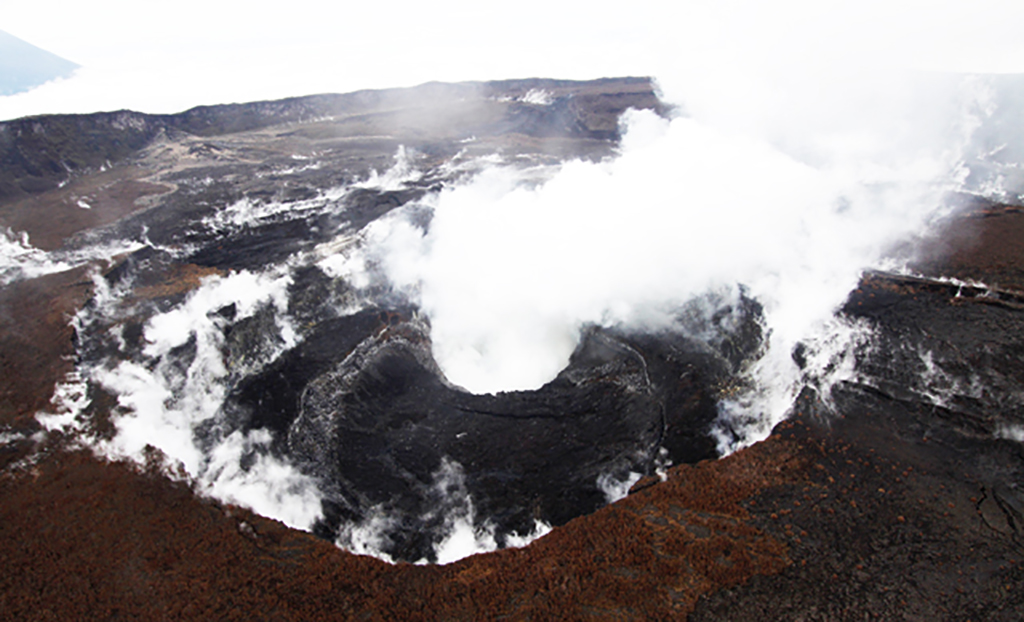 |
Figure 46. View of Nyamuragira's pit crater on 16 April 2012. Direction unknown. Courtesy Dario Tedesco, International Organization of Migrants and Second University of Naples. |
MODVOLC thermal alerts had waned at the fissure area by late March 2012, suggesting the end of the fissure eruption in that time frame. The last alerts around the summit area had occurred on 2 February 2010.
References. Kervyn, F, d'Oreye, N, van Overbeke, A-C, 2010, GORISK: The combined use of Ground-Based and Remote Sensing techniques as a tool for volcanic risk and health impact assessment for the Goma region (North Kivu, Democratic Republic of Congo). Final Report. [Project SR/00/113] (URL: http://www.ecgs.lu/gorisk/wp-content/uploads/2010/11/GORISK_Final_Report_DISSEMINATION.pdf )
Smets, B., Wauthier, C., d'Oreye, N. (2010). A new map of the lava flow field of Nyamulagira (D.R. Congo) from satellite imagery. Journal of African Earth Sciences, 58 (5), 778-786. DOI:10.1016/j.jafrearsci.2010.07.005
Geological Summary. Africa's most active volcano, Nyamulagira (also known as Nyamuragira), is a massive high-potassium basaltic shield about 25 km N of Lake Kivu and 13 km NNW of the steep-sided Nyiragongo volcano. The summit is truncated by a small 2 x 2.3 km caldera that has walls up to about 100 m high. Documented eruptions have occurred within the summit caldera, as well as from the numerous flank fissures and cinder cones. A lava lake in the summit crater, active since at least 1921, drained in 1938, at the time of a major flank eruption. Recent lava flows extend down the flanks more than 30 km from the summit as far as Lake Kivu; extensive lava flows from this volcano have covered 1,500 km2 of the western branch of the East African Rift.
Information Contacts: Dario Tedesco, International Organization of Migrants (I.O.M.), Goma, DRC, and Second University of Naples, DISTABIF, Caserta, Italy; GORISK Scientific Team [an International scientific team for the study and monitoring of active volcanoes and their corresponding hazards in the Virunga Volcanic Province] (URL: http://terra.ecgs.lu/rnvt/); Virunga National Park, Democratic Republic of Congo (URL: http://virunga.org/); Jesse Allen and Robert Simmon, NASA Earth Observatory (URL: http://earthobservatory.nasa.gov); Volcano Discovery (URL: http://www.volcanodiscovery.com/); and Afar Consortium Project (URL: http://www.see.leeds.ac.uk/afar/).