Report on Popocatepetl (Mexico) — February 2015

Bulletin of the Global Volcanism Network, vol. 40, no. 2 (February 2015)
Managing Editor: Richard Wunderman.
Popocatepetl (Mexico) During November 2012-December 2014, ongoing exhalations and explosions
Please cite this report as:
Global Volcanism Program, 2015. Report on Popocatepetl (Mexico) (Wunderman, R., ed.). Bulletin of the Global Volcanism Network, 40:2. Smithsonian Institution. https://doi.org/10.5479/si.GVP.BGVN201502-341090
Popocatepetl
Mexico
19.023°N, 98.622°W; summit elev. 5393 m
All times are local (unless otherwise noted)
This report summarizes events at Popocatépetl during November 2012-December 2014. Almost all of the data discussed came from (~800) online daily reports by the Centro Nacional de Prevención de Desastres (CENAPRED). Many of those reports are issued covering a 24 hour interval (from 1000 on the stated day back to 1000 on the previous day), with occasional cases of later supplemental reports the same day. A link to those reports is provided in the "Information Contacts" section. Our previous report on Popocatépetl discussed the ongoing eruption during July-October 2012 (BGVN 37:09).
Behavior during the reporting interval included persistent emissions (often containing ash). When visibility permitted, web cameras documented nighttime emissions containing incandescent fragments, in many cases, rising hundreds of meters above the crater rim and spreading across the upper flanks. These eruptions typically deposited tephra up to ~1.5 km from the crater where it was conspicuous on the snow and ice that crowns the summit. Occasional air photos also depicted ballistics or their impacts and tracks in the summit area. Ashfall was not uncommon in villages on the volcano and it occasionally fell in parts of Mexico City and the city of Puebla. Many plumes rose on the order of 1 km, reported by CENAPRED in many cases several times a week if not more frequently. Periods of tremor occurred, some of which lasted for more than one hour. At least one volcanic-tectonic earthquake occurred on many days (maximum coda magnitudes, Mc, generally 2.0 to 2.5). Earthquakes are in general thus dismissed from detailed discussion below; however, for one sample month, November 2013, we include a larger emphasis on the record of larger earthquakes reported daily by CENAPRED. Many of the commonplace processes such as those in the above list were sufficiently common that, in order to save space, they are often omitted from this narrative.
One way CENAPRED quantifies Popocatépetl's behavior is to use daily 'exhalations' (substantive plumes inferred to contain ash) which have long been a means of monitoring and characterizing this large and tall andesitic stratovolcano. The term 'exhalation' was used extensively in Bulletin reports starting with BGVN 22:03 in 1997. Exhalations are still currently tabulated by CENAPRED. Those appear in histograms in each daily report (assessing a 24 hour interval ending at 1000 on the stated reporting date).
Wright and others (2002) explain 'exhalations' further and clarify the distinction to the larger events that they classify as 'explosions.' The authors included photos and infrared imagery to illustrate the term (omitted here).
"Exhalations are short duration (3–90 min) ash-rich gas plumes . . .. CENAPRED provide daily Web-based activity updates in which exhalations are classified as small, moderate, or large on the basis of their duration and resultant plume height. Plumes can rise as much as 5000 m above the crater rim but are generally smaller. Exhalations are common and as many as several tens can occur each day. The ash they transport may be non-juvenile in nature (possibly with a juvenile component since March 1996 when lava extrusion began), and exhalations are thought to be the result of intermittent high-pressure gas streams that scour rock fragments from the conduit walls. Thermal video images, which measure the amount of radiation emitted in the 8–14 μm region of the electromagnetic spectrum . . ., indicate that by the time the plumes have reached the altitude of the crater rim, the ash-gas mixture is generally of a very low temperature (9–12°C at the plume exterior) due to the rapid entrainment of air at ambient temperatures.
"Explosions are less frequent than exhalations. They result in larger, darker ash plumes, with bombs often thrown clear of the crater to form a high-temperature ejecta blanket on the upper slopes of the volcano . . .. The plumes most commonly reach heights of between 3000 and 5000 m above the crater rim, although several larger explosions have occurred during the recent activity. The explosion of 30 June 1997, for example, was the largest recorded since 1922 and generated a plume 13,000 m high. Although explosions during the recent activity have been most common during periods of dome growth, they have also been observed during periods when no magmatic activity has been observed on the crater floor."
Wright and others (2002) also make this comment: "Clearly, periods of prolonged and total cloud cover will prevent any useable data being acquired." They were addressing satellite observations but this also applies to visual- and webcamera-based observations. This means that during some intervals adverse meteorological factors (clouds, rain, snow, etc.) could reduce the number of reported exhalations.
From this it is reasonably clear that the vast majority (if not all) of the eruptions during the reporting interval (November 2012-December 2014) were in the category of exhalations. During this reporting interval, several plumes did reach 3-4 km above the crater rim, as is noted below (e.g., during May-July 2013) and but we know of none reported that rose to over 5 km over the crater rim (~10.4 km altitude).
The maximum number of daily exhalations in the recent past stood, since July 2012, at 211. On 23 May 2013 that record was broken when 314 daily exhalations occurred. A second increase in that maximum value occurred twice more when the daily values reached 480 exhalations on both 4 and 6 June 2014.
As discussed in other Bulletin reporting since the onset of the eruption in March 1996 (BGVN 21:01), dramatic events involved dome dynamics in the steep-walled, cylindrical, ~0.5-km-diameter summit crater. There, emissions of lava and tephra constructed the dome. Occasional energetic discharges from the vent beneath this growing dome blew out the dome's central area, leaving the dome with a ring-shaped morphology. This process has taken place many times in the intervening years since 1996 and continued in this reporting interval too.
Further discussion and references on the topic of exhalations and explosions with particular reference to Popocatépetl also appear in other studies (e.g., de la Cruz-Reyna and others, 2008; González-Mellado and de la Cruz-Reyna, 2008; and Tárraga and others, 2012).
November 2012-December 2013 activity. During the remainder of 2012, the Alert Level remained at Yellow, Phase Two (where it had been since lowered on 1 September 2012).
The usual plumes, occasionally bearing ash, rose up to ~1 km above the crater on many days during November-December 2012. For example, during 3-4 November 2012, CENAPRED daily reports noted 9 more significant eruptions and associated plumes registered at these respective times: 1100, 1450, 1548, 2346, 0157, 0240, 0532, 0835, and 0931.
On the basis of 15-day averages shown on histograms in CENAPRED daily reports, the overall November monthly average was 43. During December 2012 the overall average was 31. Lower monthly averages than December's 31 appeared during January 2013 through the first half of March 2013. During the second half of March 2013 the average daily exhalations again rose to similar levels (31). The averages dropped again after that the averages remained low well into May and early June 2013 although during these later months some daily values increased significantly. The average value for the second half of June 2013 was 33.
During the first two weeks of May 2013 there were increases in earthquakes, tremor, and emissions. During 7-8 May, CENAPRED called attention to an episode of high amplitude spasmodic tremor. It was accompanied by an explosion on 8 May that ejected an ash plume that rose 3 km above the crater and drifted SE. Ashfall was reported from the villages of San Pedro Benito Juarez (10-12 km SE), San Juan Tianguismanalco (22 km SE), and Atlixco (23 km SE), and in some areas of the City of Puebla (~50 km to the E). The main tremor episode was accompanied by incandescent fragments that reached up to 500 m distance from Popocatépetl (chiefly NE). As reported on the 8th, during the last 24 hours CENAPRED detected 40 low intensity exhalations; 2 additional stronger ones sent a small amounts of ash towards the SE. Tremor during early May generally remained below daily intervals of up to a few hours.
On 10 May 2013 CENAPRED noted that during the last 24 hours there occurred 46 generally small exhalations. In addition, two explosions occurred, of moderate magnitude, sending ash ~1 km above the crater. Tremor duration for that interval lasted ~3 hours, including some time periods with high-amplitude signals. Three small volcano-tectonic earthquakes also occurred. A second report later on 10 May indicated that during 1142-1443 a series of ash emissions and periods of spasmodic and harmonic tremor occurred with ash plumes rising as much as 1 km above the crater, again producing ashfall. Similar plume heights were seen on 11 May, and the daily report noted there were in the last 24 hours a total of 53 (chiefly small-to-moderate) exhalations.
According to CENAPRED, seismicity had intensified on the afternoon and night prior to 12 May (when the Alert Level rose to Yellow, Phase Three, stipulating a 12 km radius exclusionary zone). Additionally, the report for 12 May 2013 said that in the last 24 h, 43 exhalations of low and moderate intensity were recorded. In general, steam-and-gas plumes with small amounts of ash rose from the crater. Although foggy conditions sometimes limited visibility, sporadic ejections of incandescent tephra fell back into the crater and onto the NNE flank, 300 m from the crater rim. Tremor registered in 1-2 hour intervals, continuously or in segments. Each such interval began with an eruptive burst of moderate intensity. The most important burst took place at 1700 on the 12th and was perceived by many residents in the E and SE sectors.
On 13 May 2013 steam-and-gas plumes were observed rising from the crater during periods of good visibility. On 14 May an explosive event generated an ash plume that rose to 3 km altitude. Incandescent tephra landed up to 600 m away on the NE flank. Cloud cover again obscured summit views. Seismicity, including tremor, remained elevated. The histogram in the daily report listed 25 exhalations during the past 24 hours.
On 14 May 2013, volcanologists aboard an overflight observed a lava dome 350 m in diameter and 50 m thick, found the dome slightly deflated after an explosion. Similar dome- related events seemingly took place again during the next few days. The histogram in the daily report listed 41 exhalations during the past 24 hours.
CENAPRED noted a vigorous eruption at 0146 on 15 May that discharged an ash plume to over 3 km above the crater rim, blown NE sending tephra up to 1.5 km downslope. At 1804 that day a second blast sent a column to somewhat below 3.5 km above the crater, blown N. Both these events correlated with spasmodic tremor. The histogram in the daily report listed 56 exhalations during the past 24 hours.
On 16 May 2013, some intervals of tremor again corresponded with discharge of glowing fragments, the majority of which fell back into the crater (a process frequently mentioned throughout the reporting interval). Ash plumes rose 2 km and drifted NE. Minor ashfall was reported in Paso de Cortés, 7 km N. Incandescent tephra reached 400 m from the crater rim to the N and NE. Seismometers registered an Mc 2.2 earthquake. The histogram in the daily report listed 55 exhalations during the past 24 hours.
Two punctuated eruptions were described for the 24-hour interval ending at 1000 on the 17th (one reaching 4 km above the rim) The first took place at 2214, when the crater issued a strong explosion; the resulting incandescent fragmental material covered the flanks to 1.5 km distance and the associated gas-and-ash column rose to under 3 km above the crater, drifting NE. The second took place at 0028, generating an eruption column to 4 km above the crater and casting glowing fragments up to 1.5 km from the crater. The report for the 17th said that moderate-to-small exhalations during the past 24 hours totaled 31. On 17, 18, 19, and 20 May 2013 histograms in the respective CENAPRED reports noted that in the past 24 hours they each registered 31, 18, 24, and 54 exhalations.
During an overflight on 18 May, volcanologists observed the active crater, 200 m wide and 40 m deep, located in the dome's surface. The rest of the dome was covered with rock fragments. Tephra had landed as far as 0.5 km down the NE flank. CENAPRED inferred that the missing material forming this crater was likely excavated by explosions associated with hours of tremor that took place during 14-17 May.
On 23-27 May 2013, tremor decreased. A flight on 28 May captured several photos, one of which appears in figure 67. Note the steep crater within the ring-shaped dome and the abundance of fragmental character of some material on the dome's surface. The CENAPRED caption also drew attention to marks made by ballistic material that burrowed into the snow and ice in the summit area.
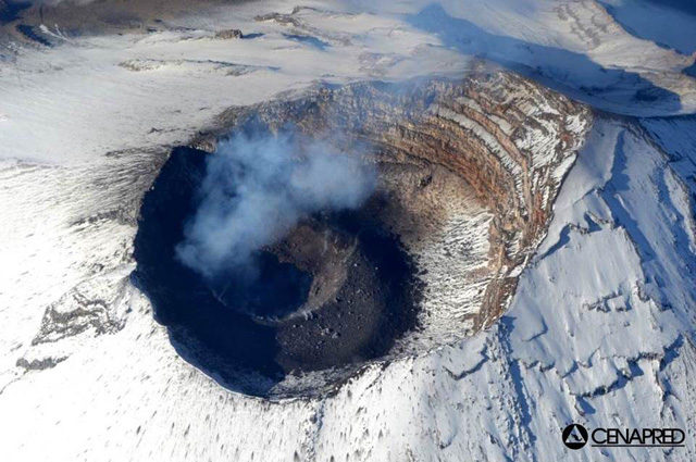 |
Figure 67. Aerial photo taken looking downward at the summit area of Popocatépetl on 28 May 2013. The summit hosts a deep, steep sided circular crater, within which grows a dome. The dome is frequently reamed out by powerful explosive bursts leaving the dome with a crater as seen here. Courtesy of CENAPRED (from their 1 June 2013 daily report). |
During 1-7 June exhalations on the daily histograms ranged between 32 and 93. They were often described as of low intensity (steam rich and ash poor), but in some cases they were described as reaching moderate intensity. Cloud cover often prevented visual observations. Volcano-tectonic earthquakes up to Mc 2.7 took place. On 7 June 2013 the Alert Level was lowered to Yellow, Phase Two.
During the rest of June 2013, significant emissions continued. For example, during 12-17 June 2013, plumes containing ash rose as high as 4 km above the crater, and ashfall was reported in many nearby villages (figure 68). For the eruption on the 17th, perceptible ash fell as far as the SE portion of Mexico City. The eruption on the 17th was accompanied by tremor with a duration of over 2 hours and other seismicity also remained at times high.
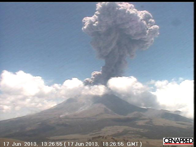 |
Figure 68. Webcam image of an explosion at Popocatépetl on 17 June 2013 (at 13:26:55 local time, which corresponds to 18:26:55 UTC). The explosion generated an ash plume that reached greater than 4 km above the crater and threw incandescent fragments up to 2 km out of the crater, causing small grassland fires. Courtesy of CENAPRED. |
An overflight on 25 June led to the insight that eruptions in the past few days had further altered the dome. It then had the dimensions of 250 m in diameter and 60 m deep.
According to CENAPRED's daily report on 3 July 2013, seismic activity increased again during the past 24 hours when the seismic network detected tremor for 36 minutes and two larger earthquakes (at 0407 and 0918 on the 3rd) with respective coda magnitudes, Mc 2.9 and 2.6. The daily report noted 84 exhalations on the part of the histogram for the last 24 hour interval ending at 1000 on 3 July. This was accompanied by persistent gas and ash emissions and diffuse ash plumes that rose 2-3.5 km above the crater and produced ashfall in areas as far as México City. Incandescent tephra was ejected short distances onto the N and E flanks.
This increased activity continued on 4 July 2013. According to news articles, multiple airlines canceled flights to and from the México City and Toluca (105 km WNW) airports on 4 July. The number of cancelled flights, according to the news, was 47. Flights resumed later that day.
On 5 July 2013, almost continuous tremor was recorded. Ash plumes drifted NW. Scientists employed both infrared webcamera imaging and an overflight to observe continuously ejected incandescent tephra that landed as far away as 1.5 km from the crater on almost all flanks, and an ash plume that rose 2 km. Cloud cover often obscured visual observations. A news article stated that four airlines canceled a total of 17 flights.
On 6 July 2013, low frequency, high amplitude tremor was accompanied by gas, steam, and ash emissions that rose 3 km. Three explosions were detected, but cloud cover prevented visual confirmation. News articles noted ashfall again in parts of México City. Government officials raised the Alert Level to Yellow, Phase Three, excluding the public within a 12 km radius of the crater. Later that day, the low frequency tremor amplitude decreased, followed by diminishing emissions of gas and ash.
During 7-9 July 2013, tremor was accompanied by persistent emissions of steam, gas, and small amounts of ash that drifted WSW and NW; cloud cover continued to hinder visual observations. Three explosions produced gas containing ash. Incandescence and ejected incandescent tephra were sometimes observed. During overflights on 7 and 10 July, scientists observed that a new lava dome, 250 m in diameter and 20 m thick, had recently formed in the crater.
During an overflight on 15 July 2013, scientists observed a 200-m wide and 20 to 30 m deep crater in the lava dome. The attributed the new morphology last seen on 10 July to dome destruction owing to explosions in the past few days. They also reported on M 2.3, 1.8 and 1.7 earthquakes, as well as 82 minutes of high-frequency tremor on 15 July 2013.
Emissions and occasional explosions that generated plumes with some ash continued during 10-16 July 2013 (figure 68). According to a news article, on 12 July 2013 an Alaska Airlines flight to México City's international airport was canceled and operations at a small airport in Puebla were suspended.
On 23 July 2013, the Alert Level was lowered to Yellow, Phase Two, a status that prevailed through December 2014 (the end of this reporting interval).
On 31 July 2013 a clear decrease in the size of the water vapor and gas plumes was observed; plumes blew down the NW flank and rose only 100 m above the crater rim. An explosion was detected at 2312 on 1 August, but cloud cover prevented confirmation of any ejecta. On 2 August minor amounts of ash fell in the Tepetlixpa, Atlautla, Ecatzingo, and Ozumba municipalities of Mexico State. On 4 August emissions of gas, steam, and ash drifted NW. During 5-6 August a few observed plumes rose 1-2 km and drifted WNW, W, and WSW.
On 14 August 2013 a period of tremor was accompanied by an ash emission that drifted W and fell on towns as far as ~20 km away. Gas-and-steam plumes were observed during 15-16 August. A period of tremor on 17 August was accompanied by an ash plume that rose 1.5 km and drifted WSW. Ash fell in in towns as far as 65 km SW (Cuernavaca). On 18 August tremor was accompanied by an ash emission that rose 1.2 km and drifted SW. On 19 August minor steam-and-gas emissions drifted W. During 19-20 August emissions likely contained small amounts of ash but cloud cover prevented confirmation. On 28 August ash plumes rose 200-800 m and drifted SW. Gas-and-steam plumes were observed the next day and on the 30th an ash plume rose 1 km above the crater and drifted W.
During much of September and October 2013 clouds sometimes blocked clear views of the volcano. The volcano continued to undergo seismic unrest and to emit steam and gas plumes often containing minor amounts of ash. Early September ash blew WSW to fall on settlements as far as 24 km away (including, on the 1st, at Tetela del Volcán, 20 km SW, and Ocuituco, 24 km SW, and on the 2nd, at Ecatzingo, 15 km SW. On 4 September the number of daily exhalation during the previous 15 days averaged at 5, but on that day it stood at 44 exhalations. Average values for 15 day intervals remained under ~25 during September through December 2013.
Other observational details from this interval are similar to those noted above. For example, on 24 October an explosion at 2111 produced an ash plume that rose 1 km and drifted SW. Eight low-intensity explosions on 26 October increased gas and steam emissions and produced slight amounts of ash.
Despite the low number of exhalations near year's end, during 30 October 5 November 2013, exhalations were frequently detected, varying from 30 to 97 times per day. Between 31 October and 5 November, four volcano tectonic earthquakes were recorded (Mc 2.1-2.5). Tremor was frequently detected; on 1 November, 3 hours and 21 minutes of high-frequency tremor was recorded.
During November 2013 tremor durations reached highs on the 5th, 6th, and 17th, respectively, at 55, 60, and 67 minutes. November's larger local earthquakes reported by CENAPRED included the following: on the 5th, Mc 2.1-2.5; 6th, Mc 2.7; 9th, Mc 2.3; 10th, two cases with Mc 2.1; 11th, Mc 2.3, 18th, three cases with Mc approaching 2; 20th, 6 cases with some Mc approaching 2.5; 21st; Mc 2.0; 22nd, five cases, Mc 2-3.5; 23rd, Mc 2.0; 24th, two cases with Mc 2.1; 25th, Mc 2.0; 28th, Mc 1.8; and 29th, Mc 1.2.
The Washington Volcanic Ash Advisory Center (VAAC) issued advisories for Popocatépetl every month during 2013, except for November and December 2013. The advisories were most numerous during April through July 2013. According to CENAPRED, a daily average of about 6,000 metric tons of sulfur dioxide was emitted during both 2013 and 2014.
2014 activity. During 2014, the Washington VAAC issued advisories for Popocatépetl every month, except for March. The number of advisories issued was considerably lower than that for 2013. At year's end, the Alert Level remained at Yellow, Phase Two.
Activity in 2014 was broadly similar to that in 2013, with above-mentioned frequent gas-and-steam emissions, often with minor ash content. Issues with limited visibility at times due to cloud cover also remained.
The 15-day average of the daily exhalations often stood at less than 4 during January and through 19 February 2014. Activity increased during 19-25 February 2014. At least eight explosions generated plumes (mostly ash) that rose 1-2 km above the crater. An explosion at 1233 on 21 February sent an ash plume to 4 km above the crater rim. On 26 February, scientists aboard an overflight observed that another lava dome (dome number 48) had been destroyed, leaving a funnel shaped cavity about 80 m deep. A new dome 20 30 m wide was at the bottom of the cavity. On 27 February, activity decreased considerably.
CENAPRED's 15-day average of the daily exhalations stood at 7 or below during March 2014 but it rose to 34 by 18 April 2014 and dropping to 22 by the end of that month. It rose again in late May 2014 (to 45 on 31 May). On 16 June it stood at 57; and for the last half of June it declined to below 10.
The daily value reached 480 exhalations on 4 and 6 June 2014, a new record.
Monitored and eruptive activity briefly increased in early July 2014. For example, CENAPRED reported tremor on 2 July (maximum of 80 minutes in 24 hours) and 12 July (minimum of 8 minutes). Up to 216 exhalations of low and moderate intensity were detected on 9 July. The 15-day average of the daily exhalations also rose during early July 2014, reaching over 50 during the first half of the month but dropping towards the end to 15 (on the 31st).
The first half of August had a 15-day average of 33 daily exhalations and the second half, 46 daily exhalations. Those averages (first half of the month and second half of the month) were as follows for the rest of the year: September (14 and 31); October (40 and 39); November (55 and 13); and December (41 and 72).
During 27 August and 2 September 2014, plumes reached as high as 3 km above the crater. Tremor and volcanic-tectonic earthquakes were recorded in early September.
On 17 September 2014, a day with 126 exhalations recorded by CENAPRED's monitoring system, an ash emission at 1813 resulted from a moderate explosion. The emission reached 3 km above the crater rim. It blew SE and light ash fell at villages in that direction. During the same day five other exhalations reached ~1.5 km above the crater rim. During 7-8 October 2014 ashfall was reported in Cuautla (43 km SW), Tetela del Volcán (20 km SW), Huaquechula (30 km SSW), and Morelos (60 km SW). On 12 October ash plumes rose 2 km and drifted NE. Ashfall was reported in Paso de Cortés (8 km NNW) and Tlalmanalco (30 km NW).
CENAPRED reported that during a 14 October 2014 overflight, volcanologists observed that the diameter of the inner crater (formed in July 2013) had increased to 350 m. The bottom of the inner crater floor was 100 m below the floor of the main crater, cup shaped, and covered with tephra. No sign of the lava dome (number 52) emplaced in early August 2014 was visible. Steam emissions originated from a crack in the N wall of the inner crater and ash emission came from the bottom of the crater.
Although for brevity we have generally excluded examples of explosions and ashfall for September and October 2014, which were broadly similar to previous months, a small explosion at 0317 on 25 October ejected tephra 100 m outboard onto the S flank. A steam-and-gas plume containing a small amount of ash rose 1.5 km above the crater and drifted SW. Ashfall was reported in Tetela del Volcán (20 km SW). A small explosion at 0111 on 26 October ejected a plume that rose 1.1 km above the crater rim and sent tephra 200 m onto the N flank.
Histograms in daily reports issued during 3-5 November 2014 described exhalations totaling 267, 190, and 147, respectively. These were broadly described as a continuous gas-and-steam plume, mainly with minor amounts of ash. Some more vigorous and ash rich emissions occurred and, for example, on 5 November the plume rose as high as 1 km and caused light ashfall in Paso de Cortés. That daily report also showed videos that showed incandescent fragments spreading ~800 m over the upper flanks. The 5 November report also showed a seismic record captured in the interval 2000 on the 4th to 0130 on the 5th illustrating ~190 seismic events. About an hour after those events, the same record indicated an Mc 2.1 earthquake. On 6 November, a small rockslide on the SW flank was recorded by a webcam and the seismic network. Scientists aboard an overflight observed a new dome (number 53), emplaced during 4 5 November; it was an estimated 250 m in diameter and 30 m thick.
During 7 11 November 2014, seismicity indicated continuing gas-and-steam emissions, with small amounts of ash. Incandescence from the crater was observed most nights. Explosions during 10-11 November ejected incandescent tephra and generated ash plumes that rose 1.2 km above the crater. Gas-and-steam emissions continued through the rest of November.
During December 2014, occasional explosions continued, generating ash plumes that rose as high as 3-3.5 km, resulting in minor ashfall on nearby villages. One or more rockslides were noted in addition to the usual small ash plumes, the occasional incandescence at the crater and associated with tephra. One plume on 8 December rose to 3 km above the crater. CENAPRED reported that the international airport in Puebla was temporarily closed on 17 December 2014 due to ashfall from an explosion that generated a 2 km high ash plume. The explosion also ejected incandescent tephra that landed 700 m down the N flank. During an overflight during the last half of December, volcanologists observed a lava dome at the bottom of the crater. The Alert Level remained at Yellow, Phase Two.
References: de la Cruz-Reyna, S, Yokoyama, I, Martínez-Bringas, A, and Ramos, E, 2008, Precursory seismicity of the 1994 eruption of Popocatépetl Volcano, Central Mexico. Bulletin of Volcanology, 70(6), 753-767.
González-Mellado, AO, and de la Cruz-Reyna, S, 2008, A simplified equation of state for the density of silicate hydrous magmas: an application to the Popocatépetl buoyancy-driven dome growth process. Journal of Volcanology and Geothermal Research, 171(3), 287-300.
Tárraga, M, de la Cruz-Reyna, S, Mendoza-Rosas, A, Carniel, R, Martínez-Bringas, A, García, A, and Ortiz, R, 2012, Dynamical parameter analysis of continuous seismic signals of Popocatépetl volcano (Central Mexico): A case of tectonic earthquakes influencing volcanic activity. Acta Geophysica, 60(3), 664-681.
Wright, RS, de La Cruz-Reyna, S, Harris, A, Flynn, L, and Gomez-Palacios, JJ, 2002, Infrared satellite monitoring at Popocatépetl: Explosions, exhalations, and cycles of dome growth, J. Geophys. Res., 107(B8), doi: 10.1029/2000JB000125.
Geological Summary. Volcán Popocatépetl, whose name is the Aztec word for smoking mountain, rises 70 km SE of Mexico City to form North America's 2nd-highest volcano. The glacier-clad stratovolcano contains a steep-walled, 400 x 600 m wide crater. The generally symmetrical volcano is modified by the sharp-peaked Ventorrillo on the NW, a remnant of an earlier volcano. At least three previous major cones were destroyed by gravitational failure during the Pleistocene, producing massive debris-avalanche deposits covering broad areas to the south. The modern volcano was constructed south of the late-Pleistocene to Holocene El Fraile cone. Three major Plinian eruptions, the most recent of which took place about 800 CE, have occurred since the mid-Holocene, accompanied by pyroclastic flows and voluminous lahars that swept basins below the volcano. Frequent historical eruptions, first recorded in Aztec codices, have occurred since Pre-Columbian time.
Information Contacts: Centro Nacional de Prevencion de Desastres (CENAPRED) (URL: https://www.gob.mx/cenapred/); Washington Volcanic Ash Advisory Center (URL: http://www.ospo.noaa.gov/Products/atmosphere/vaac/index.html); Agence France Presse (AFP)(URL: http://www.afp.com/en/); Associated Press (URL: http://www.ap.org/); Stuff (URL: http://www.stuff.co.nz).