Report on Sangeang Api (Indonesia) — October 2016

Bulletin of the Global Volcanism Network, vol. 41, no. 10 (October 2016)
Managing Editor: Edward Venzke.
Research and preparation by Robert Andrews.
Sangeang Api (Indonesia) Large explosions in May 2014 followed by thermal anomalies until early November 2015
Please cite this report as:
Global Volcanism Program, 2016. Report on Sangeang Api (Indonesia) (Venzke, E., ed.). Bulletin of the Global Volcanism Network, 41:10. Smithsonian Institution. https://doi.org/10.5479/si.GVP.BGVN201610-264050
Sangeang Api
Indonesia
8.2°S, 119.07°E; summit elev. 1912 m
All times are local (unless otherwise noted)
On 21 May 2014 the PVMBG (Pusat Vulkanologi dan Mitigasi Bencana Geologi) issued an alert for Sangeang Api based on elevated seismic activity. An explosive eruption followed on 30 May (BGVN 39:02), sending a dense column of ash and sulfur dioxide billowing more than 3 km above the volcano. Two larger explosions occurred the next day. No further explosive activity was seen, but thermal anomalies were recorded by satellite-based instruments during June-December 2014 and March-November 2015.
Review of May-June 2014 activity. PVMBG reported that during January-29 May 2014 diffuse white plumes rose at most 25 m above the crater. On 30 May seismicity increased, with tremor starting at 0500 and becoming continuous at 1348. An eruption at 1555 generated an ash plume that rose 3 km and drifted W, causing ashfall over the sea. The Alert Level was raised to 3 (on a scale of 1-4). The island has no permanent settlements, and is only occupied during the growing and harvest seasons; civil authorities evacuated 135 people to the mainland. Based on satellite images, pilot observations, and the Indonesian Meteorological Office, the Darwin VAAC reported that the 30 May ash plume rose to an altitude of 15.2 km and drifted 440 km E and 750 km SE (figure 15).
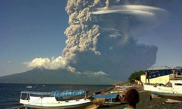 |
Figure 15. An ash plume rises from Sangeang Api during eruption on 30 May 2014. Photo taken looking NE from Sumbawa Island. Courtesy of Australian Associated Press |
BNPB reported that on 31 May two larger explosions occurred at 1330 and 2242 hours. According to the VAAC, ash plumes from those explosions rose to altitudes of 13.7-15.2 km and drifted 280 km NW and other various directions. Later in the day the ash plumes became detached. Ashfall affected many areas in the Bima Regency on the mainland, including Wera, and prompted the evacuation of 7,328 people from four villages within a radius of 8 km from Sangeang Api. The Bima and Tambolaka airports were temporarily closed. According to a news article, all flights to and from the Darwin International Airport in Australia on 31 May were canceled.
The VAAC noted that ash plumes rose to an altitude of 4.3 km on 1 June 2014 and drifted W and SW. During 2-3 June ash plumes rose to altitudes of 3-4.3 km and drifted 45 km W. During clear conditions on 1-17 June, incandescence at the summit and white-and-gray plumes (100-1,500 m above the summit) were visible. On 1 June 2014 seismicity dramatically decreased, and as of 17 June was still declining. The Alert Level was reduced from 3 to 2 (on a scale of 1-4) on 17 June.
Activity during 2015. PVMBG observers at the Sangeang Api post in Desa Sangeang Darat, Bima, West Nusa Tenggara, reported that during 1 July-30 September 2015 diffuse white plumes rose up to 250 m above the crater rim. During 1 October-1 November 2015 white-to-gray plumes rose as high as 350 m. Beginning on 23 October occasional weak thumping noises were reported. Crater incandescence possibly indicated lava-dome growth or lava-flow advancement. The Alert Level remained at 2 (on a scale of 1-4); visitors and residents were warned not to approach the crater within a 1.5-km radius.
Thermal anomaly data. Nearly daily thermal alerts were measured by MODVOLC (using MODIS data) following the 30 May eruption from 7 June until about 27 December 2014. Alerts appeared again, frequently but not daily, between 17 March and 13 October 2015, with a final alert pixel on 5 November 2015. MIROVA measured low to medium radiative power thermal anomalies from early June 2014 until late November 2015.
Geological Summary. Sangeang Api volcano, one of the most active in the Lesser Sunda Islands, forms a small 13-km-wide island off the NE coast of Sumbawa Island. Two large trachybasaltic-to-tranchyandesitic volcanic cones, Doro Api and Doro Mantoi, were constructed in the center and on the eastern rim, respectively, of an older, largely obscured caldera. Flank vents occur on the south side of Doro Mantoi and near the northern coast. Intermittent eruptions have been recorded since 1512, most of them during in the 20th century.
Information Contacts: Pusat Vulkanologi dan Mitigasi Bencana Geologi (PVMBG, also known as Indonesian Center for Volcanology and Geological Hazard Mitigation, CVGHM), Jalan Diponegoro 57, Bandung 40122, Indonesia (URL: http://www.vsi.esdm.go.id/); Darwin Volcanic Ash Advisory Centre (VAAC), Bureau of Meteorology, Northern Territory Regional Office, PO Box 40050, Casuarina, NT 0811, Australia (URL: http://www.bom.gov.au/info/vaac/); The Guardian News (URL: https://www.theguardian.com/world/2014/may/31/indonesian-volcanic-ash-cloud-halts-flights-in-and-out-of-darwin); MIROVA (Middle InfraRed Observation of Volcanic Activity), a collaborative project between the Universities of Turin and Florence (Italy) supported by the Centre for Volcanic Risk of the Italian Civil Protection Department (URL: http://www.mirovaweb.it/); Hawai'i Institute of Geophysics and Planetology (HIGP), MODVOLC Thermal Alerts System, School of Ocean and Earth Science and Technology (SOEST), Univ. of Hawai'i, 2525 Correa Road, Honolulu, HI 96822, USA (URL: http://modis.higp.hawaii.edu/, http://modis.higp.hawaii.edu/).