Report on Tengger Caldera (Indonesia) — December 2016
Bulletin of the Global Volcanism Network, vol. 41, no. 12 (December 2016)
Managing Editor: Edward Venzke.
Research and preparation by Robert Andrews.
Tengger Caldera (Indonesia) New eruption begins 12 November 2015; ash plumes cause airport closure in December 2015 and July 2016
Please cite this report as:
Global Volcanism Program, 2016. Report on Tengger Caldera (Indonesia) (Venzke, E., ed.). Bulletin of the Global Volcanism Network, 41:12. Smithsonian Institution. https://doi.org/10.5479/si.GVP.BGVN201612-263310
Tengger Caldera
Indonesia
7.942°S, 112.95°E; summit elev. 2329 m
All times are local (unless otherwise noted)
Activity at the Bromo cone of Tengger Caldera during April 2011 to early October 2012 was characterized by ongoing seismicity and an eruption during April-June 2011 (BGVN 37:10). No activity was reported in late 2012 or throughout 2013 by the observatory, Pusat Vulkanologi dan Mitigasi Bencana Geologi (PVMBG, also known as CVGHM). White emissions were noted by PVMBG during a short period in 2014, and one day of thermal alerts were identified by MODVOLC and MIROVA, using MODIS satellite data. White emissions were also observed during most of 2015. An eruption began in November 2015 and continued for about a year; the last report of ash came from the Darwin Volcanic Ash Advisory Centre (VAAC) on 12 November 2016.
Information in this report comes from Darwin VAAC satellite observations (plume identification, altitude, and drift direction); infrared MODIS satellite data (processed by MODVOLC and MIROVA); and PVMBG and/or Badan Nacional Penanggulangan Bencana (BNPB) (geophysical measurements, field observations, Alert Levels).
Tengger caldera is a 16-km-wide feature found at N end of volcanic massif extending from the active Semeru volcano. A sketch map of the caldera from 1844 is essentially identical to the current morphology of the cones (figure 7).
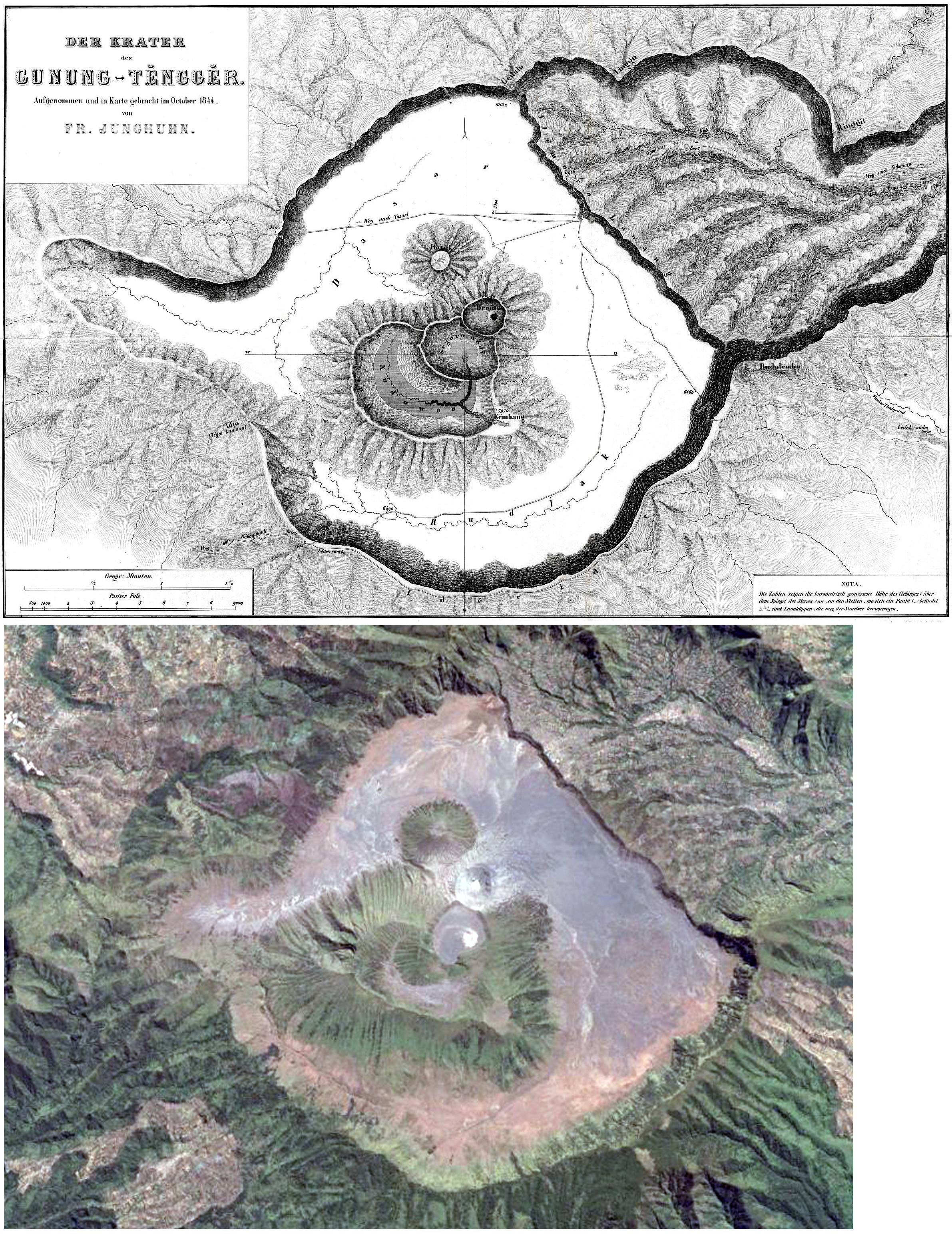 |
Figure 7. The sketch (top) is a 19th century map of Tengger Caldera showing several volcanoes within the caldera (Junghuhn, 1844). The satellite image (bottom) acquired in September 2013 (Google Earth) shows that the morphology of the caldera is largely unchanged. |
Activity slightly increased for a short period in 2014. PVMBG reported that during 1-30 April diffuse white plumes rose 50 m above the crater rim. Seismicity increased during 15-30 April. From 1 to 4 May seismicity again increased and denser white plumes rose as high as 250 m. On 4 May the Alert Level was raised to 2 (the second highest level on a scale of 1-4). Residents and visitors were warned not to approach the crater within a radius of 1 km. Later that year, on 22 October, an alert characterized by a three-pixel thermal anomaly was issued by MODVOLC.
Non-eruptive activity during 2014-2015. PVMBG reported that during mid-April through mid-July 2015 white plumes continued to rise at most 100 m above the crater rim. A sulfur dioxide odor was noted at the Bromo observation post. Seismicity was dominated by tremor, but also included volcanic earthquakes. Two thermally elevated pixels triggered a MODVOLC alert during 17-18 September and a five-pixel alert was issued for 25 October.
During 1 August-4 December 2015 white plumes rose as high as 150 m above the crater rim, and an intense sulfur dioxide odor was noted at the Bromo observation post. Seismicity was dominated by tremor, but also included deep and shallow volcanic earthquakes; RSAM values increased at the beginning of November, and then sharply increased in the beginning of December. Based on seismic analysis, visual observations, and hazard potential, the Alert Level was raised to 3 (on a scale of 1-4) on 4 December. Residents and visitors were warned not to approach the crater within a radius of 2.5 km.
Eruptive activity during 2015-2016. On 5, 8, and 12 November 2015 booming noises were reported and emissions rose 1.2 km above the crater; small amounts of ash were present in the emissions on 12 November. On 15, 23, and 27 November dense ash plumes rose 150 m above the crater rim.
Based on information from PVMBG and satellite images, the Darwin VAAC reported that during 5 and 7-15 December ash plumes rose to an altitude of 3 km and drifted 55-185 km in almost all directions. On 15 December BNPB reported that activity remained high; gray-brown ash plumes rose 1.5 km above the crater and drifted W and NW. Weak rumbling was noted. According to a news article, ash emitted on that same day caused the Abdul Rachman Saleh Airport (26 km W) in Malang to close. BNPB reported ash plumes rising from the cone on 16 December 2015. The Darwin VAAC reported that during 17-19, and 21-31 December ash plumes rose to altitudes of 3-4.2 km and drifted as far as 95 km W, NW, N, E, and SE.
Ash emissions were regularly observed during 1 January-12 November 2016 by both the Darwin VAAC and PVMBG observers. Ash-plume altitudes fluctuated between 2.7 and 4.2 km, or 0.4-1.9 km above the crater rim; plumes drifted in multiple directions as far as 205 km (figure 8). PVMBG reported that during 14-22 January brownish gray plumes rose as high as 1.8 km above the crater. Two low-power thermal anomalies were reported by MIROVA, one in mid-January and one later in the month. On 26 February the Alert Level was lowered to 2. On 18 April one low-power thermal anomaly was identified.
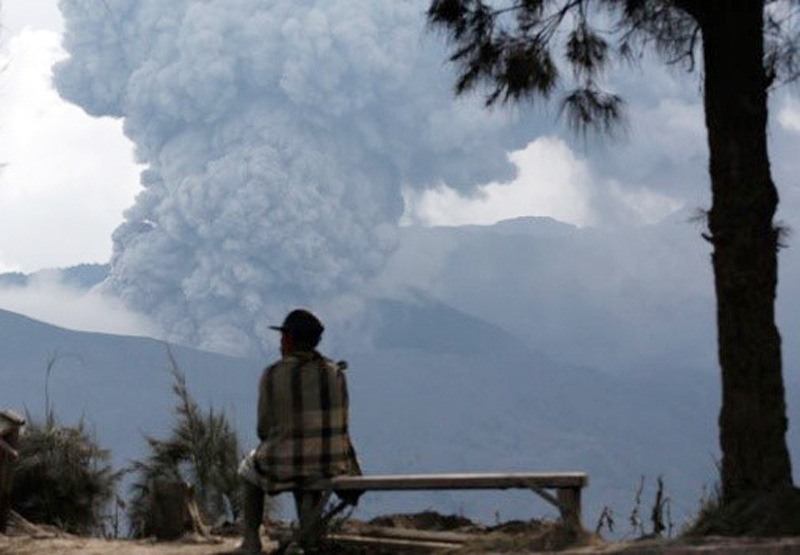 |
Figure 8. Photo of a man watching an ash plume rising from the Bromo cone in Tengger Caldera on 5 January 2016. Courtesy of Reuters/Darren Whiteside. |
Ash plumes occasionally affected surrounding populated areas. BNPB reported that the Abdul Rachman Saleh Airport in Malang (26 km W) closed from 2300 on 11 July 2016 to 0900 on 12 July due to thin ash deposits around the airport. BNPB reported that the same airport closed again due to ash from 2307 on 15 July to 0900 on 16 July; six flights were diverted and two were cancelled. Minor amounts of ash fell in the communities of Probolinggo (35 km NE) and Lumajang (36 km SW).
PVMBG reported that during 1 June-25 September 2016 brownish gray plumes rose as high as 1.2 km above the crater. A sulfur odor was noted at the Bromo observation post, thunderous noises sometimes vibrated the post doors, and occasionally crater incandescence was observed. The deformation network measured inflation. On 26 September the Alert Level was raised to 3 (on a scale of 1-4); residents and visitors were reminded not to approach the crater within a radius of 2.5 km. PVMBG reported that during 1-20 October brownish, reddish, and grayish gray plumes rose as high as 900 m above the crater and drifted E, NW, W, and SW. Seismic activity was dominated by constant tremor although the amplitude decreased. On 20 October the Alert Level was lowered to 2 (on a scale of 1-4).
Seismic data for 1 January-20 October 2016 (figure 9) included RSAM values for seismically detected eruptions (Letusan), emissions (Hembusan), shallow volcanic signals (VB), deep volcanic signals (VA), and local (TL) and distant (TJ) tectonic earthquakes. Sulfur dioxide emissions fluctuated between about 100 and 450 tonnes/day (t/d) during 17 July-5 October 2016 (figure 10). Measurements were often hampered by fog. For comparison, previous measurements of sulfur dioxide emissions occurred in October 2005, March 2007, December 2008, and December 2009.
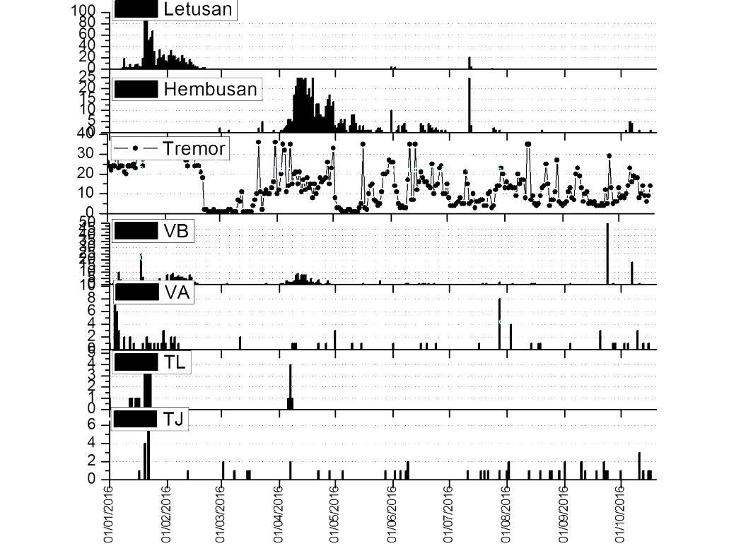 |
Figure 9. RSAM values for seismically detected eruptions (Letusan), emissions (Hembusan), shallow volcanic signals (VB), deep volcanic signals (VA), and local (TL) and far (TJ) tectonic earthquakes cover the period during 1 January-20 October 2016. |
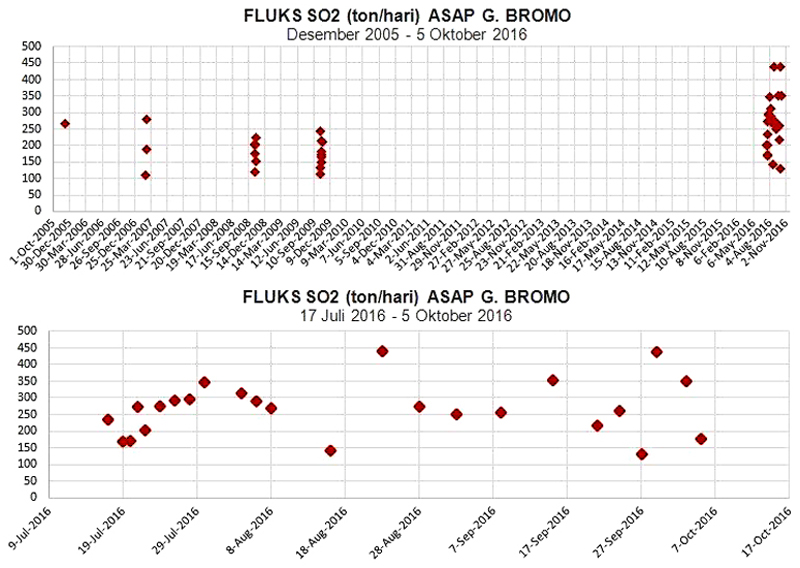 |
Figure 10. Sulfur dioxide emissions in tons/day from 1 October 2005 to 2 November 2016 (top) and an expanded view from 17 July to 24 September 2016 (bottom). Courtesy of PVMBG. |
References: Junghuhn, Franz Wilhelm, 1844, Java, seine Gestalt, Pflanzendecke und innere Bauart, 2. Band (Java , its shape , plant cover and interior design , 2. Band, Tengger Mountains), recorded by Franz Wilhelm Junghuhn. From Wikipedia (URL: https://nl.wikipedia.org/wiki/Franz_Junghuhn).
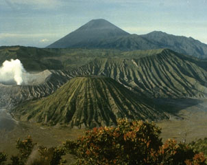
Geological Summary. The 16-km-wide Tengger caldera is located at the northern end of a volcanic massif extending from Semeru volcano. The massive volcanic complex dates back to about 820,000 years ago and consists of five overlapping stratovolcanoes, each truncated by a caldera. Lava domes, pyroclastic cones, and a maar occupy the flanks of the massif. The Ngadisari caldera at the NE end of the complex formed about 150,000 years ago and is now drained through the Sapikerep valley. The most recent of the calderas is the 9 x 10 km wide Sandsea caldera at the SW end of the complex, which formed incrementally during the late Pleistocene and early Holocene. An overlapping cluster of post-caldera cones was constructed on the floor of the Sandsea caldera within the past several thousand years. The youngest of these is Bromo, one of Java's most active and most frequently visited volcanoes.
Information Contacts: Pusat Vulkanologi dan Mitigasi Bencana Geologi (PVMBG, also known as Indonesian Center for Volcanology and Geological Hazard Mitigation, CVGHM), Jalan Diponegoro 57, Bandung 40122, Indonesia (URL: http://www.vsi.esdm.go.id/); Darwin Volcanic Ash Advisory Centre (VAAC), Bureau of Meteorology, Northern Territory Regional Office, PO Box 40050, Casuarina, NT 0811, Australia (URL: http://www.bom.gov.au/info/vaac/); Badan Nasional Penanggulangan Bencana (BNPB), National Disaster Management Agency, Graha BNPB - Jl. Scout Kav.38, East Jakarta 13120, Indonesia (URL: http://www.bnpb.go.id/); MIROVA (Middle InfraRed Observation of Volcanic Activity), a collaborative project between the Universities of Turin and Florence (Italy) supported by the Centre for Volcanic Risk of the Italian Civil Protection Department (URL: http://www.mirovaweb.it/); Hawai'i Institute of Geophysics and Planetology (HIGP), MODVOLC Thermal Alerts System, School of Ocean and Earth Science and Technology (SOEST), Univ. of Hawai'i, 2525 Correa Road, Honolulu, HI 96822, USA (URL: http://modis.higp.hawaii.edu/, http://modis.higp.hawaii.edu/); Reuters (URL: https://en.tempo.co/read/news/2016/01/26/055739393/Mount-Bromo-Erupting-Lava).