Report on Krakatau (Indonesia) — September 2017

Bulletin of the Global Volcanism Network, vol. 42, no. 9 (September 2017)
Managing Editor: Edward Venzke.
Research and preparation by Robert Andrews.
Krakatau (Indonesia) Eruption during 17-19 February 2017 sends large lava flow down the SE flank
Please cite this report as:
Global Volcanism Program, 2017. Report on Krakatau (Indonesia) (Venzke, E., ed.). Bulletin of the Global Volcanism Network, 42:9. Smithsonian Institution. https://doi.org/10.5479/si.GVP.BGVN201709-262000
Krakatau
Indonesia
6.1009°S, 105.4233°E; summit elev. 285 m
All times are local (unless otherwise noted)
The most recent reported eruptive activity from the Anak Krakatau cone was a pilot report of an ash plume on 31 March 2014 (BGVN 40:08). Monitoring reports by the Pusat Vulkanologi dan Mitigasi Bencana Geologi (PVMBG, also known as Indonesian Center for Volcanology and Geological Hazard Mitigation, CVGHM) from January 2014 through July 2015 only noted seismicity and fumarolic emissions.
The only indication of possible eruptive activity in the second half of 2015 through 2016 reported by PVMBG was a Volcano Observatory Notice for Aviation (VONA) on 20 June. The seismograph at the Anak Krakatau Volcano Observatory detected an eruption at 0551 local time (2251 UTC), but the eruption was not observed visually because of cloudy weather. There had been a swarm of volcanic earthquakes about one day earlier, and seismicity had significantly increased 3 hours before the eruption. After the eruption, seismicity gradually decreased. Although thermal anomalies were frequently recorded in 2016 (figure 36, bottom), they may have been a result of strong hot fumaroles at the summit dome; no PVMBG or tourist reports indicated active lava flows or ash plumes.
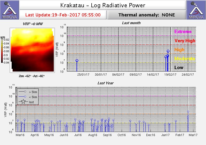 |
Figure 36. Thermal anomalies at Krakatau identified by the MIROVA system using MODIS data for the year ending 19 February 2017. The record indicates regular thermal signatures, which may be a result of strong fumarolic activity in the summit crater. Courtesy of MIROVA. |
The PVMBG reported that seismicity was dominated by shallow volcanic earthquakes in February 2017. In a Volcano Observatory Notice for Aviation (VONA), the aviation color code was reported to be raised to Orange. Emission earthquakes increased beginning on 17 February and gradually formed continuous tremor. At 1535 on 17 February 2017 at 1535 infrared MODIS data recorded by MODVOLC measured a 2-pixel thermal alert from the Aqua satellite, and on 18 February 2017 at 0650 a 2-pixel thermal alert was measured from the Terra satellite. Satellite thermal anomalies identified by the MIROVA system showed a strong sequence of anomalies around this same time (figure 36, top). Harmonic tremor began to be recorded at 1810 on 19 February. Almost an hour later, at 1904, Strombolian explosions ejected incandescent material 200 m high.
O.L. Andersen, a professional photographer, visited Anak Krakatau 25-26 February 2017. The eruption earlier in the month had resulted in a new lava flow on the SE flank (figure 37) where the September 2012 lava flow was located. He observed that "The new layer of lava-flow is black, compared to the red color of the 2012 lava flow. The lava flow has cooled down since the material was deposited. Fresh volcanic blocks were also seen distributed on the SE, S, E flank of Krakatau." No eruptions of ash were observed by Andersen, but gas emissions were present. Further, Andersen noted "After having studied aerial views of the crater area (figure 38), it seems that the source vent of the new lava-flow, is the same vent (main, central vent) that was involved in the 2012 eruption. On the top of the vent, it now seems to be a lava-dome...."
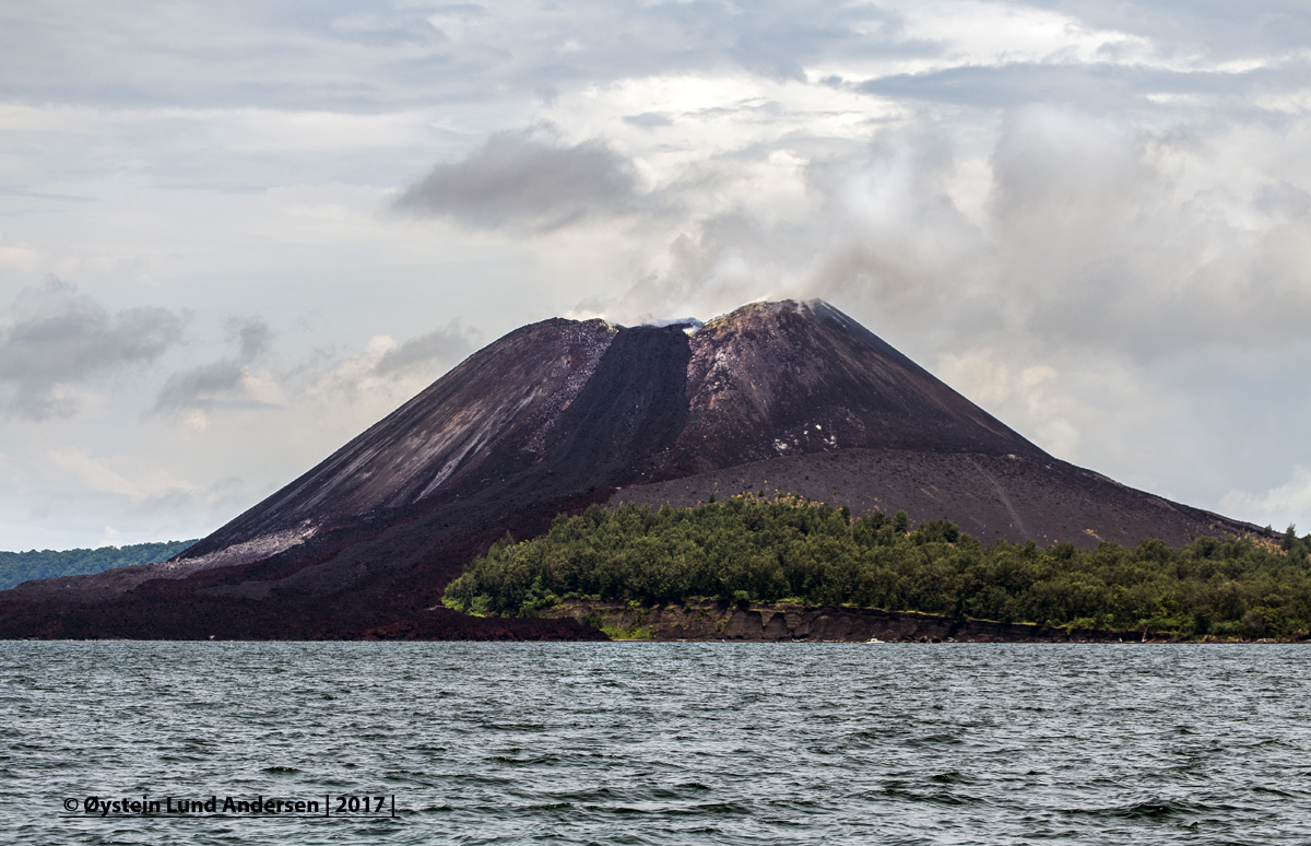 |
Figure 37. The new lava flow on Anak Krakatau of February 2017 shows up as black material on top of the more reddish colored lava from the September 2012 event. The flow came from the new vent at the summit. Copyrighted image courtesy of O.L. Andersen (used with permission). |
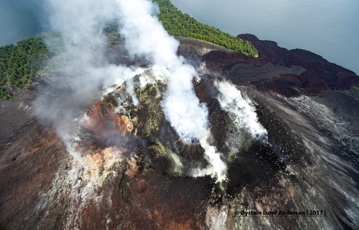 |
Figure 38. Aerial view of the summit of Anak Krakatau taken looking E on 25 February 2017. The new lava shows as a black flow from the summit toward the upper right into the ocean. The northern vent is on the crater rim left of the center of the photograph. Copyrighted image courtesy of O.L. Andersen (used with permission). |
A comparison of photos from October 2015 and February 2017 composed by Andersen showed the morphological changes during that time, including the new dome and lava flows (figure 39). Incandescence was obvious at night (figure 40) and from aerial observations of the lava dome Andersen noted that the area with incandescence was small, and that "the lava dome did not appear to be overly active." Andersen observed further that the "main crater and summit area today seem to be of a more complex and dynamic character than it was before the eruption of September 2012. From footage of 2010/2011 the main crater was seen to be broad and fairly deep. Now the main crater is filled with material, with two lava flows originating from this vent running down on the SW and E flanks. On the northern side of the summit an eruption vent is also clearly observed...."
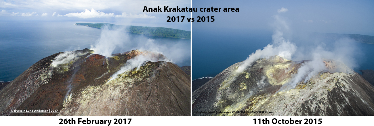 |
Figure 39. A comparison of the Anak Krakatau summit area of 26 February 2017 and 11 October 2015 taken looking west. Note the new dome in the center of the 2017 photo and the new lava that came from the vent and flowed down the SE slope of the volcano. Copyrighted image courtesy of O.L. Andersen (used with permission). |
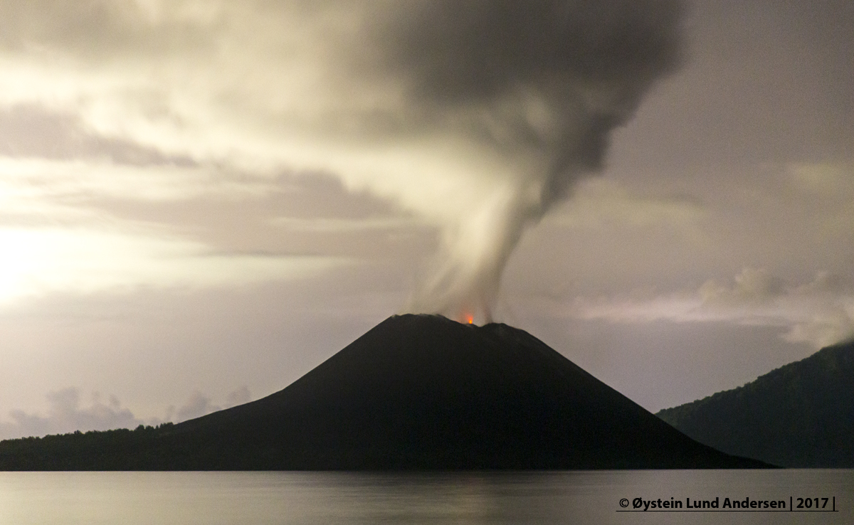 |
Figure 40. Incandescence from Anak Krakatau on the evening of 25 February 2017. Copyrighted image courtesy of O.L. Andersen (used with permission). |
Geological Summary. The renowned Krakatau (frequently mis-named as Krakatoa) volcano lies in the Sunda Strait between Java and Sumatra. Collapse of an older edifice, perhaps in 416 or 535 CE, formed a 7-km-wide caldera. Remnants of that volcano are preserved in Verlaten and Lang Islands; subsequently the Rakata, Danan, and Perbuwatan cones were formed, coalescing to create the pre-1883 Krakatau Island. Caldera collapse during the catastrophic 1883 eruption destroyed Danan and Perbuwatan, and left only a remnant of Rakata. This eruption caused more than 36,000 fatalities, most as a result of tsunamis that swept the adjacent coastlines of Sumatra and Java. Pyroclastic surges traveled 40 km across the Sunda Strait and reached the Sumatra coast. After a quiescence of less than a half century, the post-collapse cone of Anak Krakatau (Child of Krakatau) was constructed within the 1883 caldera at a point between the former Danan and Perbuwatan cones. Anak Krakatau has been the site of frequent eruptions since 1927.
Information Contacts: Øystein Lund Andersen (URL: http://www.oysteinlundandersen.com/krakatau-volcano/visit-to-anak-krakatau-volcano-february-2017/); Pusat Vulkanologi dan Mitigasi Bencana Geologi (PVMBG, also known as Indonesian Center for Volcanology and Geological Hazard Mitigation, CVGHM), Jalan Diponegoro 57, Bandung 40122, Indonesia (URL: http://www.vsi.esdm.go.id/); Hawai'i Institute of Geophysics and Planetology (HIGP) - MODVOLC Thermal Alerts System, School of Ocean and Earth Science and Technology (SOEST), Univ. of Hawai'i, 2525 Correa Road, Honolulu, HI 96822, USA (URL: http://modis.higp.hawaii.edu/); MIROVA (Middle InfraRed Observation of Volcanic Activity), a collaborative project between the Universities of Turin and Florence (Italy) supported by the Centre for Volcanic Risk of the Italian Civil Protection Department (URL: http://www.mirovaweb.it/).