Report on Kick 'em Jenny (Grenada) — November 2017
Bulletin of the Global Volcanism Network, vol. 42, no. 11 (November 2017)
Managing Editor: Edward Venzke.
Research and preparation by Jackie Gluck.
Kick 'em Jenny (Grenada) Short eruption on 29 April 2017
Please cite this report as:
Global Volcanism Program, 2017. Report on Kick 'em Jenny (Grenada) (Venzke, E., ed.). Bulletin of the Global Volcanism Network, 42:11. Smithsonian Institution. https://doi.org/10.5479/si.GVP.BGVN201711-360160
Kick 'em Jenny
Grenada
12.3°N, 61.64°W; summit elev. -185 m
All times are local (unless otherwise noted)
A submarine volcano located about 8 km off the N coast of Grenada, Kick 'em Jenny most recently had erupted during 23-24 July 2015 (BVGN 40:08), when two submarine explosions had been detected. This report covers a short-lived eruption on 29 April 2017 as reported by the Seismic Research Centre (SRC) at the University of the West Indies (UWI).
An advisory notice issued on 29 April 2017 by the Grenada National Disaster Management Agency (NaDMA) in collaboration with UWI-SRC reported increased seismicity associated with the volcano, including a high-amplitude signal lasting 25 seconds. The notice advised marine operators to strictly observe a 5-km maritime exclusion zone (figure 10). Another NaDMA notice on 3 May set the alert level at Yellow, indicating that all vessels should observe the 1.5 km exclusion zone, though as a precaution remaining outside the 5-km zone was recommended.
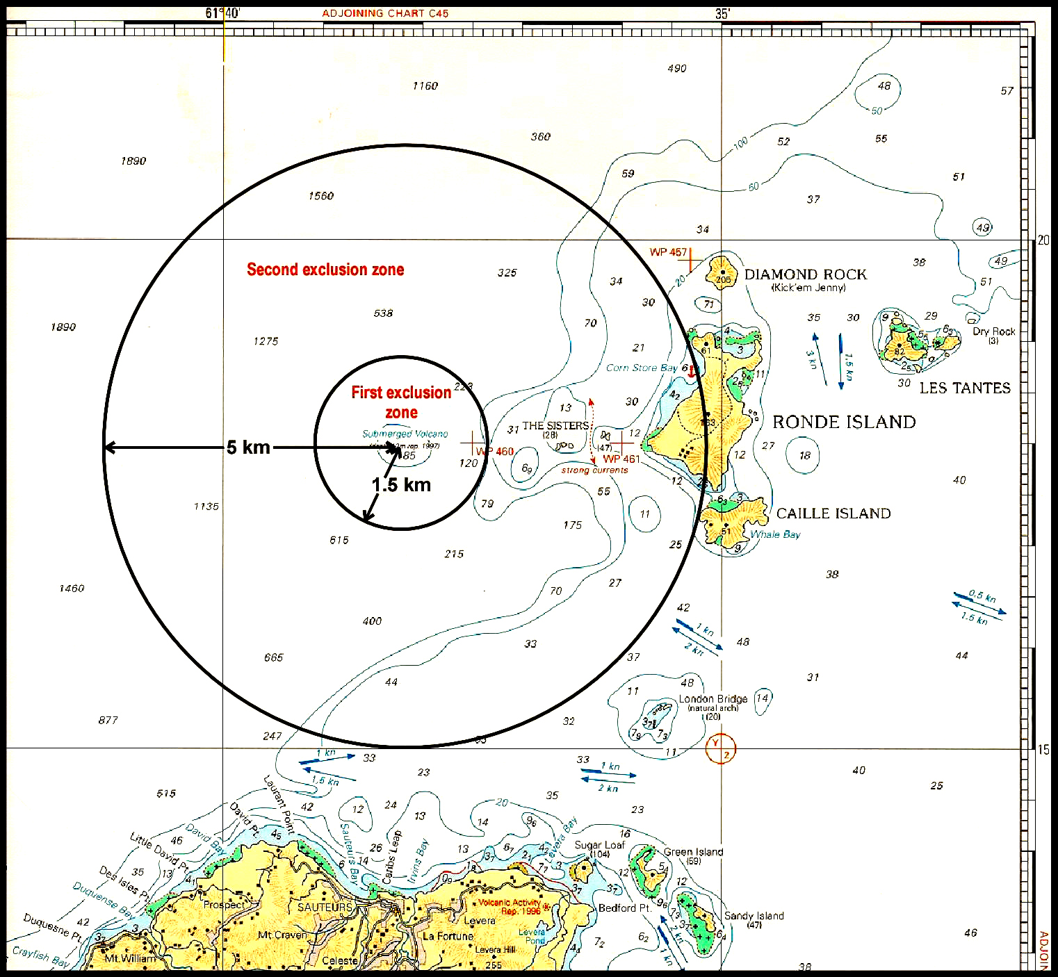 |
Figure 10. Map showing the two maritime exclusion zones defined at Kick 'em Jenny, north of the island of Grenada. Courtesy of NaDMA. |
As described by Latchman et al. (2017) in an SRC Open File report on 11 July 2017, subsequent eruptive activity on 29 April 2017 consisted of one event which lasted 14 minutes, followed by about an hour of tremor. The period of unrest began on 8 April with one earthquake. On the days following that first event, and prior to the eruption, there were 0-2 daily volcano-tectonic earthquakes, with 16 in all leading up to the eruption. The eruption was felt in northern Grenada and Martinique as an extended period of shaking, and very high-amplitude T-phases were recorded in Montserrat. There was no surface activity observed. After the eruption there was a sharp increase in the number of hybrid seismic events, with an additional 84 events up to 2 May, after which the activity ceased (figure 11).
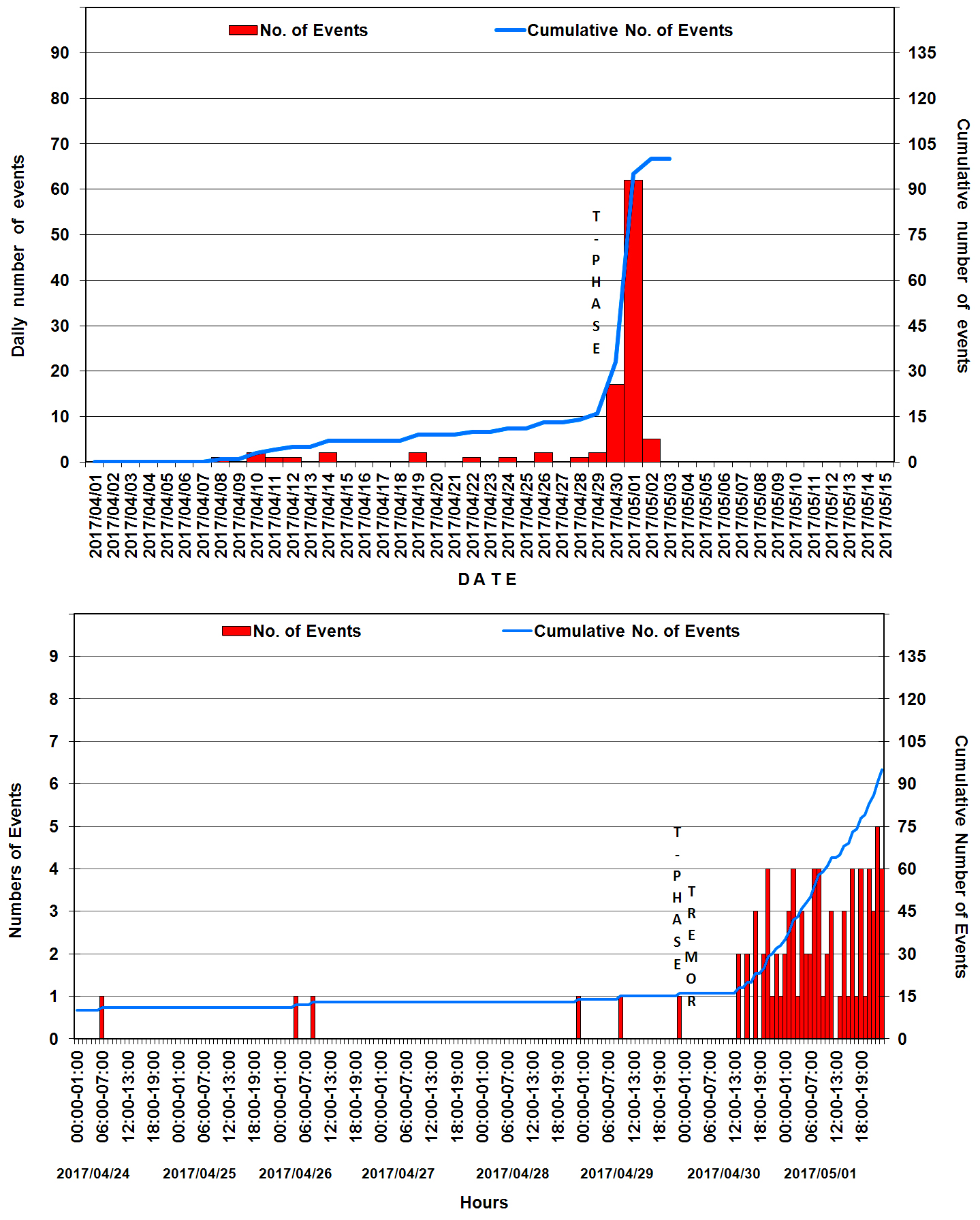 |
Figure 11. Seismicity associated with the 2017 period of unrest at Kick 'em Jenny plotted as a daily count during 1 April through 15 May (top) and as an hourly count during 24 April-1 May 2017 (bottom). From Latchman et al. (2017); courtesy of University of the West Indies, Seismic Research Centre. |
According to UWI-SRC, the 2017 precursory seismicity was low level, the eruption occurred without intensification of the seismicity, and the post-eruption seismicity was relatively abundant, but short-lived. This volcanic episode came just 21 months after an episode consisting of two weeks of precursory seismicity, two hour-long eruptions on 23 and 24 July, and rapid decay of post-eruption seismicity.
Reference: Latchman J, Robertson R, Lynch L, Dondin F, Ramsingh C, Stewart R, Smith P, Stinton A, Edwards S, Ash C, Juman A, Joseph E, Nath N, Juman I, Ramsingh H, Madoo F, 2017, 2017/04/29 Eruption of Kick-'em Jenny Submarine Volcano: SRC Open File Report Kick-'em-Jenny, Grenada 201706_VOLC1, Seismic Research Centre, The University of the West Indies, St. Augustine, Trinidad, West Indies.
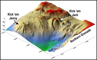
Geological Summary. Kick 'em Jenny, an active submarine volcano 8 km off the N shore of Grenada, rises 1,300 m from the sea floor. Recent bathymetric surveys have shown evidence for a major arcuate collapse structure, which was the source of a submarine debris avalanche that traveled more than 15 km W. Bathymetry also revealed another submarine cone to the SE, Kick 'em Jack, and submarine lava domes to its S. These and subaerial tuff rings and lava flows at Ile de Caille and other nearby islands may represent a single large volcanic complex. Numerous eruptions have occurred since 1939, mostly documented by acoustic signals. Prior to the 1939 eruption, when an eruption cloud rose 275 m above the ocean and was witnessed by a large number of people in northern Grenada, there had been no written mention of the volcano. Eruptions have involved both explosive activity and the quiet extrusion of lava flows and lava domes in the summit crater; deep rumbling noises have sometimes been heard onshore. Recent eruptions have modified the morphology of the summit crater.
Information Contacts: Seismic Research Centre (SRC), The University of the West Indies (UWI), St. Augustine, Trinidad and Tobago, West Indies (URL: http://www.uwiseismic.com/); National Disaster Management Agency (NaDMA), Fort Frederick, Richmond Hill, St. George's, Grenada, West Indies (URL: http://nadma.gd/).