Report on Kadovar (Papua New Guinea) — October 2018
Bulletin of the Global Volcanism Network, vol. 43, no. 10 (October 2018)
Managing Editor: Edward Venzke.
Research and preparation by Paul Berger.
Kadovar (Papua New Guinea) Intermittent ash plumes; thermal anomalies in the crater and Coastal Vent through September 2018
Please cite this report as:
Global Volcanism Program, 2018. Report on Kadovar (Papua New Guinea) (Venzke, E., ed.). Bulletin of the Global Volcanism Network, 43:10. Smithsonian Institution. https://doi.org/10.5479/si.GVP.BGVN201810-251002
Kadovar
Papua New Guinea
3.608°S, 144.588°E; summit elev. 365 m
All times are local (unless otherwise noted)
The first confirmed eruption of Kadovar began on 5 January 2018 with dense ash plumes and steam and a lava flow. The eruption continued through February and then slowed during March (BGVN 43:04). This report describes notices of ash plumes from the Darwin Volcanic Ash Advisory Centre (VAAC) and satellite images during April through 1 October 2018.
According to the Darwin VAAC a pilot observed an ash plume rising to an altitude of 1.2 km on 10 June. The ash plume was not identified in satellite data. Another ash plume identified by a pilot and in satellite images rose to an altitude of 1.8 km on 20 June and drifted W. An ash plume was visible in satellite images on 28 September drifting SE at an altitude of 2.1 km. On 1 October an ash plume rose to 2.7 km and drifted W.
Infrared satellite data from Sentinel-2 showed hot spots in the summit crater and at the Coastal Vent along the W shoreline on 10, 15, and 25 April 2018; plumes of brown discolored water were streaming from the western side of the island (figure 18). Similar activity was frequently seen during clear weather in the following months. A steam plume was also often rising from the crater. The Coastal Vent cone was still hot on 8 August, but no infrared anomaly was seen in imagery from 28 August through September.
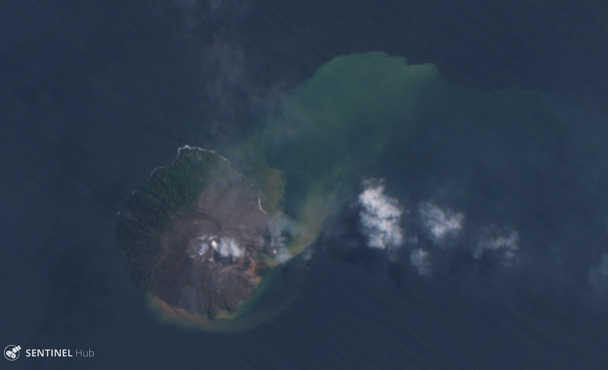 |
Figure 18. Sentinel-2 natural color satellite image of Kadovar on 10 April 2018. The island is about 1.5 km in diameter. Steam can be seen rising from the summit and the Coastal Vent just off the western shore; both locations show thermal anomalies in infrared imagery. Discolored water plumes extend NE from the island. Courtesy of Sentinel Hub Playground. |
Geological Summary. The 2-km-wide island of Kadovar is the emergent summit of a Bismarck Sea stratovolcano of Holocene age. It is part of the Schouten Islands, and lies off the coast of New Guinea, about 25 km N of the mouth of the Sepik River. Prior to an eruption that began in 2018, a lava dome formed the high point of the andesitic volcano, filling an arcuate landslide scarp open to the south; submarine debris-avalanche deposits occur in that direction. Thick lava flows with columnar jointing forms low cliffs along the coast. The youthful island lacks fringing or offshore reefs. A period of heightened thermal phenomena took place in 1976. An eruption began in January 2018 that included lava effusion from vents at the summit and at the E coast.
Information Contacts: Darwin Volcanic Ash Advisory Centre (VAAC), Bureau of Meteorology, Northern Territory Regional Office, PO Box 40050, Casuarina, NT 0811, Australia (URL: http://www.bom.gov.au/info/vaac/); Sentinel Hub Playground (URL: https://www.sentinel-hub.com/explore/sentinel-playground).