Report on Krakatau (Indonesia) — October 2018

Bulletin of the Global Volcanism Network, vol. 43, no. 10 (October 2018)
Managing Editor: Edward Venzke.
Edited by A. Elizabeth Crafford.
Krakatau (Indonesia) Strombolian, lava flow, and explosive activities resume, June-October 2018
Please cite this report as:
Global Volcanism Program, 2018. Report on Krakatau (Indonesia) (Crafford, A.E., and Venzke, E., eds.). Bulletin of the Global Volcanism Network, 43:10. Smithsonian Institution. https://doi.org/10.5479/si.GVP.BGVN201810-262000
Krakatau
Indonesia
6.1009°S, 105.4233°E; summit elev. 285 m
All times are local (unless otherwise noted)
Krakatau volcano in the Sunda Strait between Java and Sumatra, Indonesia experienced a major caldera collapse, likely in 535 CE, that formed a 7-km-wide caldera ringed by three islands (see inset figure 23, BGVN 36:08). Remnants of this volcano coalesced to create the pre-1883 Krakatau Island which collapsed during the 1883 eruption. The post-collapse cone of Anak Krakatau (Child of Krakatau), constructed within the 1883 caldera has been the site of frequent eruptions since 1927. The most recent event was a brief episode of Strombolian activity, ash plumes, and a lava flow during the second half of February 2017. Activity resumed in late June 2018 and continued through early October, the period covered in this report. Information is provided primarily by the Indonesian Center for Volcanology and Geological Hazard Mitigation, referred to as Pusat Vulkanologi dan Mitigasi Bencana Geologi (PVMBG). Aviation reports are provided by the Darwin Volcanic Ash Advisory Center (VAAC), and photographs came from several social media sources and professional photographers.
After the brief event during February 2017, Anak Krakatau remained quiet for about 15 months. PVMBG kept the Alert Level at II, noting no significant changes until mid-June 2018. Increased seismicity on 18 June was followed by explosions with ash plumes beginning on 21 June. Intermittent ash emissions were accompanied by Strombolian activity with large blocks of incandescent ejecta that traveled down the flanks to the ocean throughout July. Explosions were reported as short bursts of seismic activity, repeating multiple times in a day, and producing dense black ash plumes that rose a few hundred meters from the summit. Similar activity continued throughout August, with the addition of a lava flow visible on the S flank that reached the ocean during 4-5 August. Generally increased activity in September resulted in the highest ash plumes of the period, up to 4.9 km altitude on 8 September; high-intensity explosions were heard tens of kilometers away during 9-10 September. PVMBG reported significantly increased numbers of daily explosions during the second half of the month. The thermal signature recorded in satellite data also increased during September, and a large SO2 plume was recorded in satellite data on 23 September.
Activity during June-July 2018. PVMBG noted an increase in seismic activity beginning on 18 June 2018. Foggy conditions hampered visual observations during 19-20 June, but on 21 June gray plumes were observed rising 100-200 m above the summit (figure 41). Two ash plumes were reported on 25 June; the first rose to about 1 km altitude and drifted N, and the second rose to 600 m altitude and drifted S (figure 42).
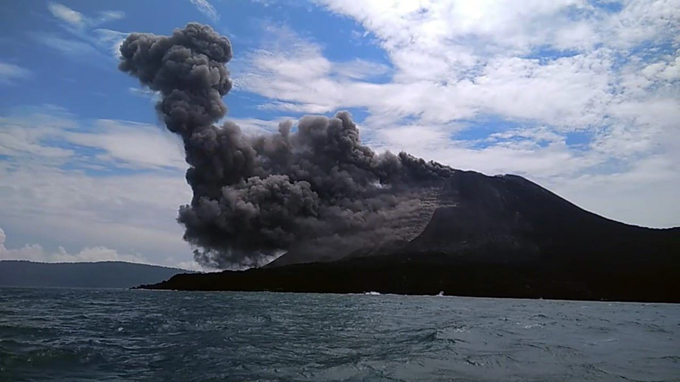 |
Figure 41. Anak Krakatau began a new eruptive episode on 21 June 2018 with an ash plume that rose 200 m above the summit. Photo by undisclosed source, courtesy of Øystein Lund Andersen. |
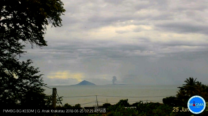 |
Figure 42. The first of two ash plumes rose to about 1 km altitude and drifted N from Anak Krakatau on 25 June 2018; the first events after about 18 months of no activity were reported on 21 June. Courtesy of PVMBG (Eruption Information on Mt. Anak Krakatau, June 25, 2018). |
Incandescence was observed at the summit during 1-2 July 2018, and two ash emissions were reported in VONA's (Volcano Observatory Notice for Aviation) on 3 July. PVMBG reported that during 4-5 July there were four additional ash-producing events, each lasting between 30 and 41 seconds. The last three of these events produced ash plumes that rose 300-500 m above the crater rim and drifted N and NW. The Darwin VAAC reported essentially continuous ash emissions during 3-9 July drifting generally W and SW at about 1.2 km altitude (figure 43). They were intermittently visible in satellite imagery when not obscured by meteoric clouds.
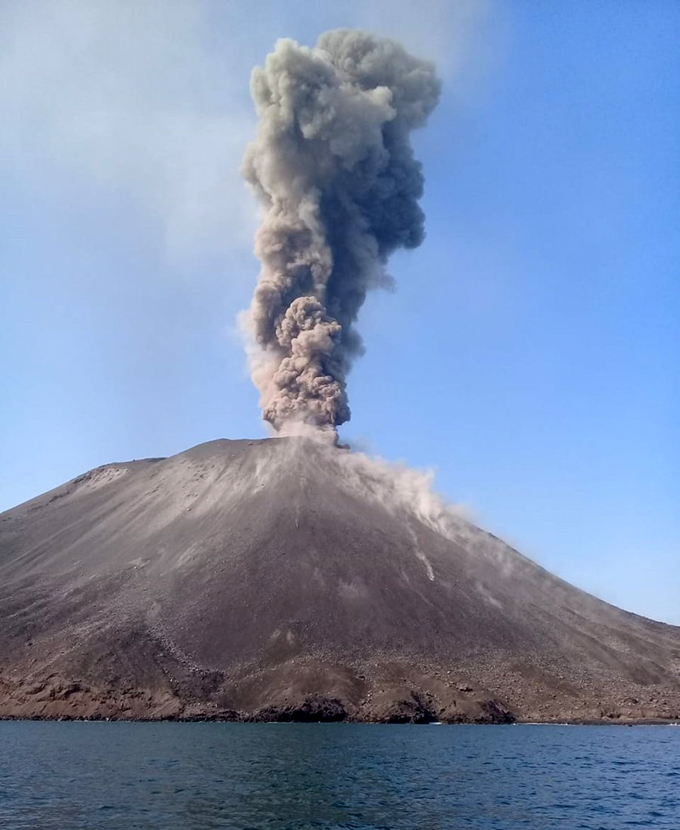 |
Figure 43. A dense gray ash plume rose several hundred meters above Anak Krakatau on 7 July 2018 (local time) while large volcanic bombs traveled down the flanks. Photo by Sam Hidayat, courtesy of Øystein Lund Andersen. |
Ash plumes were again observed by the Darwin VAAC in satellite imagery beginning on 13 July 2018 at 1.2 km altitude drifting NW. They were essentially continuous until they gradually decreased and dissipated early on 17 July, rising to 1.2-1.5 km altitude and drifting W, clearly visible in satellite imagery several times during the period. Satellite imagery revealed hotspots several times during July; they ranged from small pixels at the summit (9 July) to clear flow activity down the SE flank on multiple days (12, 19, and 24 July) (figure 44). In the VONA's reported by PVMBG during 15-17 July, they noted intermittent explosions that lasted around 30-90 seconds each. PVMBG reported a black ash plume 500 m above the summit drifting N during the afternoon of 16 July. The Darwin VAAC continued to report ash emission to 1.2-1.5 km altitude during 18-19 July, moving in several different directions; Strombolian activity sent incandescent ejecta in all directions on 19 July (figure 45). During 25-26 July the Darwin VAAC noted continuous minor ash emissions drifting SW at 1.2 km altitude, and a hotspot visible in infrared imagery.
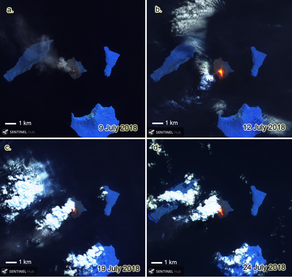 |
Figure 44. Sentinel-2 satellite imagery clearly documented the repeated thermal activity at Anak Krakatau throughout July 2018. a) 9 July 2018: a small hotspot was visible at the summit and an ash plume drifted NW. b) 12 July 2018: a much larger hotspot showed a distinct flow down the SE flank. c) 19 July 2018: even under partly cloudy skies, incandescent ejecta is visible on the S flank. d) 24 July 2018: incandescent lava had almost reached the SE coast. Sentinel-2 images with Atmospheric Penetration view (bands 12, 11, and 8A), courtesy of Sentinel Hub Playground. |
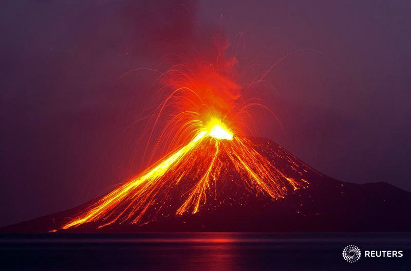 |
Figure 45. Strombolian activity sent incandescent ejecta down all the flanks and into the sea at Anak Krakatau on 19 July 2018, as seen from the island of Rakata (5 km SE). Courtesy of Reuters / Stringer. |
Activity during August-early October 2018. A series of at least nine explosions took place on 2 August 2018 between 1333 and 1757 local time. They ranged from 13 to 64 seconds long, and produced ash plumes that drifted N. The Darwin VAAC reported minor ash observed in imagery at around 2 km altitude for much of the day. In a special report, PVMBG noted a black ash plume 500 m above sea level drifting N at 1757 local time. Continued explosive activity was reported by local observers during the early nighttime hours of 3 August (figure 46).
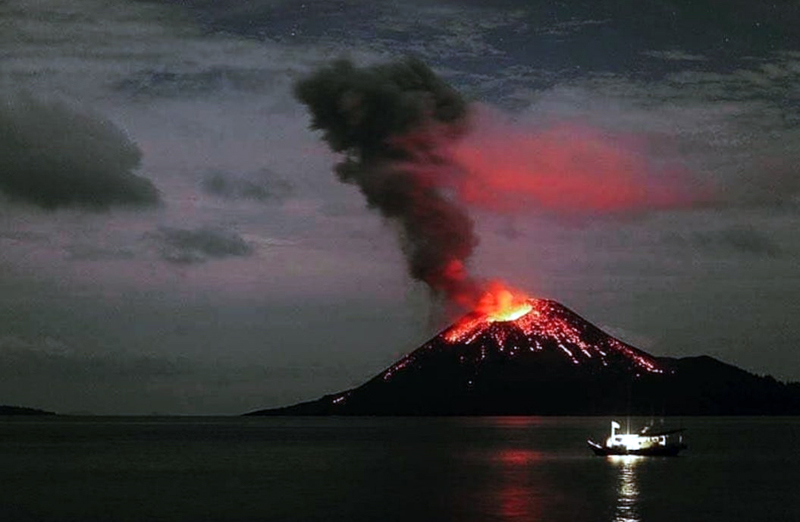 |
Figure 46. A dark ash plume rose 100-200 m from Anak Krakatau during the early morning hours of 3 August 2018, and incandescent ejecta rolled down the flanks. Tens of explosions were heard in Serang (80 km E) and Lampung (80 km N). Courtesy of Sutopo Purwo Nugroho. |
The Darwin VAAC reported continuous ash emissions rising to 1.8 km altitude and drifting E on 5 August, clearly visible in satellite imagery, along with a strong hotspot. The ash plume drifted SE then S the next day before dissipating. PVMBG reported incandescence visible during the nights of 5-15 August. Photographer Øystein Lund Andersen visited Krakatau during 4-6 August 2018 and recorded Strombolian activity, lava bomb ejecta, and a lava flow entering the ocean (figures 47-50).
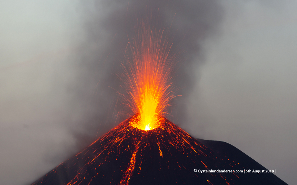 |
Figure 47. Strombolian explosions sent incandescent ejecta skyward, and blocks of debris down the flanks of Anak Krakatau on 5 August 2018 as captured in this drone photograph. Copyrighted photo by Øystein Lund Andersen, used with permission. |
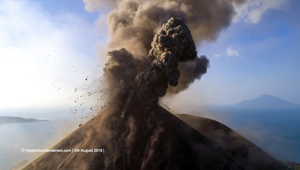 |
Figure 48. Large volcanic bombs flew out from the summit vent of Anak Krakatau while a dark gray plume of ash rose a few hundred meters on 5 August 2018 in this drone photograph. Copyrighted photo by Øystein Lund Andersen, used with permission. |
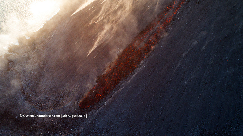 |
Figure 49. A blocky lava flow traveled down the S flank of Anak Krakatau on 5 August 2018 in this closeup image taken by a drone. Copyrighted photo by Øystein Lund Andersen, used with permission. |
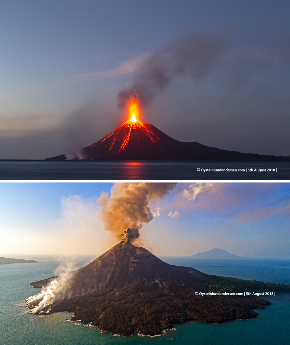 |
Figure 50. Views of Anak Krakatau from the SE showed Strombolian activity and incandescent lava (upper photo) and steam from the lava flowing into the ocean and dark ash emissions from the summit (lower photo) on 5 August 2018. Copyrighted photo by Øystein Lund Andersen, used with permission. |
Emissions were reported intermittently drifting W on 11, 14, and 16 August at 1.2-1.5 km altitude. Video of explosions on 12 August with large bombs and dark ash plumes were captured by photographer James Reynolds (Earth Uncut TV). PVMBG reported black ash plumes drifting N at 500 m above the summit on 17 and 18 August after explosions that lasted 1-2 minutes each. The Darwin VAAC also reported ash plumes rising to 1.2 km altitude on 17-18 drifting NE. VONA's were issued during 22-23 August reporting at least three explosions that lasted 30-40 seconds and produced ash plumes that drifted N and NE. The Darwin VAAC reported the plume on 22 August as originating from a vent below the summit. PVMBG noted that a dark plume on 23 August drifted NE at about 700 m above the summit. During 27-30 August, the Darwin VAAC reported ash plumes intermittently visible in satellite imagery extending SW at 1.2-1.5 km altitude.
Ash plumes drifting N and NW were visible in satellite imagery during 3-4 September at 1.2-1.5 km altitude. The Darwin VAAC reported an ash plume moving NW and W at 4.9 km altitude on 8 September, the highest plume noted for the report period. The following day, the plume height had dropped to 1.5 km altitude, and was clearly observed drifting W in satellite imagery. A hotspot was reported on 12 September. During the night of 9-10 September PVMBG reported bursts of incandescent material rising 100-200 m above the peak, with explosions that rattled windows at the Anak Krakatau PGA Post, located 42 km from the volcano. Ash plumes continued to be observed through 13 September. The Darwin VAAC reported continuous ash emissions to 1.8 km altitude drifting W and NW on 16-17 September (figure 51). The ash plume was no longer visible on 18 September, but a hotspot remained discernable in satellite data through 20 September.
 |
Figure 51. On 16 September 2018 a dark ash plume rose several hundred meters above Anak Krakatau as incandescent lava flowing down the SE flank to the sea created steam plumes. Courtesy of Thibaud Plaquet. |
PVMBG reported incandescence at the summit and gray and black ash plumes on 20 September that rose 500 m above the summit. A low-level ash emission was reported drifting S on 21 September and confirmed in the webcam. Four VONA's were issued that day, reporting explosions at 0221, 0827, 2241, and 2248, lasting from 72-115 seconds each. PVMBG subsequently reported observing 44 explosions with black ash plumes rising 100-600 m above the summit, and incandescence at night on 21 September. Ash emissions continued on 22 September at 1.5 km altitude, with a secondary explosion rising to 2.4 km altitude drifting W. The plume height was based on and infrared temperature measurement of 12 degrees C. Later in the day, an additional plume was observed in satellite imagery at 3.7 km altitude drifting N. PVMBG reported observations of 56 explosions, with 200-300 m high (above the summit) black ash plumes and incandescence at night on 22 September. Observations from nearby Rakata Island on 22 September indicated that tephra from incandescent explosions of the previous night mostly fell on the flanks, but some reached the sea. A lava flow on the SSE flank had also reached the ocean (figure 52).
 |
Figure 52. Activity at Krakatau during 22-23 September 2018 included substantial Strombolian explosions, a dark ash plume, lava flows, and large volcanic bombs traveling nearly to the ocean. Photo courtesy of Malmo Travel. |
By 23 September 2018, a single plume was observed at 2.1 km altitude drifting WNW. A glow at the summit was visible in the webcam that day, and a hotspot was seen in satellite imagery the next day as observations of an ash plume drifting W at 2.1 km continued. A significant SO2 plume was captured in satellite data on 23 September (figure 53).
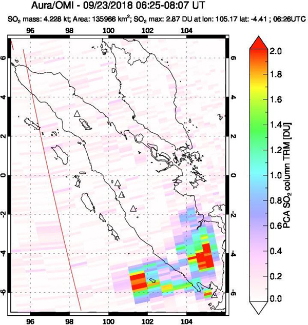 |
Figure 53. A significant SO2 plume dispersed NW of Krakatau (lower right corner) on 23 September 2018 after a surge in activity was observed the previous two days. Courtesy of NASA Goddard Space Flight Center. |
On 24 September, PVMBG reported black ash plumes rising 1,000 m above the summit, incandescence at the summit, and lava flowing 300 m down the S flank observed in the webcam during the night. An ash plume was observed by the Darwin VAAC drifting WSW and then W on 25-26 September at 2.1 km altitude, lowering slightly to 1.8 km the following day, and to 1.2 km on 28 September. Continuous ash emissions were observed through 29 September. A new emission was reported on 30 September drifting SW at 1.8 km altitude. Ash emissions were observed daily by the Darwin VAAC from the 1st to at least 5 October at 2.1 km altitude drifting W. A large hotspot near the summit was noted on 3 October. The thermal activity at Anak Krakatau from late June into early October 2018, as recorded in infrared satellite data by the MIROVA project, confirmed the visual observations of increased activity that included Strombolian explosions, lava flows, ash plumes, and incandescent ejecta witnessed by ground observers during the period (figure 54).
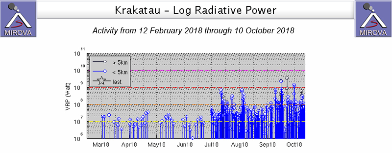 |
Figure 54. The MIROVA project graph of thermal activity at Krakatau from 12 February through early October 2018 showed the increasing thermal signature that appeared in late June at the onset of renewed explosive activity, the first since February 2017. Courtesy of MIROVA. |
Geological Summary. The renowned Krakatau (frequently mis-named as Krakatoa) volcano lies in the Sunda Strait between Java and Sumatra. Collapse of an older edifice, perhaps in 416 or 535 CE, formed a 7-km-wide caldera. Remnants of that volcano are preserved in Verlaten and Lang Islands; subsequently the Rakata, Danan, and Perbuwatan cones were formed, coalescing to create the pre-1883 Krakatau Island. Caldera collapse during the catastrophic 1883 eruption destroyed Danan and Perbuwatan, and left only a remnant of Rakata. This eruption caused more than 36,000 fatalities, most as a result of tsunamis that swept the adjacent coastlines of Sumatra and Java. Pyroclastic surges traveled 40 km across the Sunda Strait and reached the Sumatra coast. After a quiescence of less than a half century, the post-collapse cone of Anak Krakatau (Child of Krakatau) was constructed within the 1883 caldera at a point between the former Danan and Perbuwatan cones. Anak Krakatau has been the site of frequent eruptions since 1927.
Information Contacts: Pusat Vulkanologi dan Mitigasi Bencana Geologi (PVMBG, also known as Indonesian Center for Volcanology and Geological Hazard Mitigation, CVGHM), Jalan Diponegoro 57, Bandung 40122, Indonesia (URL: http://www.vsi.esdm.go.id/); Darwin Volcanic Ash Advisory Centre (VAAC), Bureau of Meteorology, Northern Territory Regional Office, PO Box 40050, Casuarina, NT 0811, Australia (URL: http://www.bom.gov.au/info/vaac/); MIROVA (Middle InfraRed Observation of Volcanic Activity), a collaborative project between the Universities of Turin and Florence (Italy) supported by the Centre for Volcanic Risk of the Italian Civil Protection Department (URL: http://www.mirovaweb.it/); Sentinel Hub Playground (URL: https://www.sentinel-hub.com/explore/sentinel-playground); Sutopo Purwo Nugroho, BNPB (Twitter: @Sutopo_PN, URL: https://twitter.com/Sutopo_PN); Øystein Lund Andersen (Twitter: @OysteinLAnderse, https://twitter.com/OysteinLAnderse, URL: http://www.oysteinlundandersen.com); Reuters Latam (Twitter: @ReutersLatam, URL: http://www.reuters.com/); James Reynolds, Earth Uncut TV (Twitter: @EarthUncutTV, URL: https://www.earthuncut.tv/, Video: https://www.youtube.com/watch?v=UD3SLWtuPZs); Thibaud Plaquet (Instagram: tibomvm, URL: https://www.instagram.com/tibomvm/); Malmo Travel (Instagram: malmo.travel, URL: https://www.instagram.com/malmo.travel/).