Ambae
Vanuatu
15.389°S, 167.835°E; summit elev. 1496 m
All times are local (unless otherwise noted)
Ambae is one of the active volcanoes of Vanuatu in the New Hebrides archipelago. Recent eruptions have resulted in multiple evacuations of the local population due to ashfall. The current eruption began in September 2017, with the initial episode ending in November that year. The second episode was from late December 2017 to early February 2018, and the third was during February-April 2018. The Alert Level was raised to 3 in March, then lowered to Level 2 again on 2 June 2018. Eruptive activity began again on 1 July and produced thick ash deposits that significantly impacted the population, resulting in the full evacuation of the Island of Ambae. This report summarizes activity from July 2018 through January 2019 and is based on reports by the Vanuatu Meteorology and Geo-hazards Department (VMGD), The Vanuatu Red Cross, posts on social media, and various satellite data.
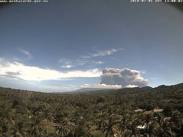
On 1 July Ambae entered a new eruption phase, marked by an ash plume that resulted in ashfall on communities in the W to NW parts of Ambae Island and the NE part of Santo Island (figure 78). On 9-10 July VMGD reported that a small eruption continued with activity consisting of ongoing gas-and-steam emissions. An observation flight on 13 July confirmed that the eruption was centered at Lake Voui and consisted of explosions that ejected hot blocks with ongoing gas-and-steam and ash emissions. Populations on Ambae and a neighboring island could hear the eruption, smell the volcanic gases, and see incandescence at night.
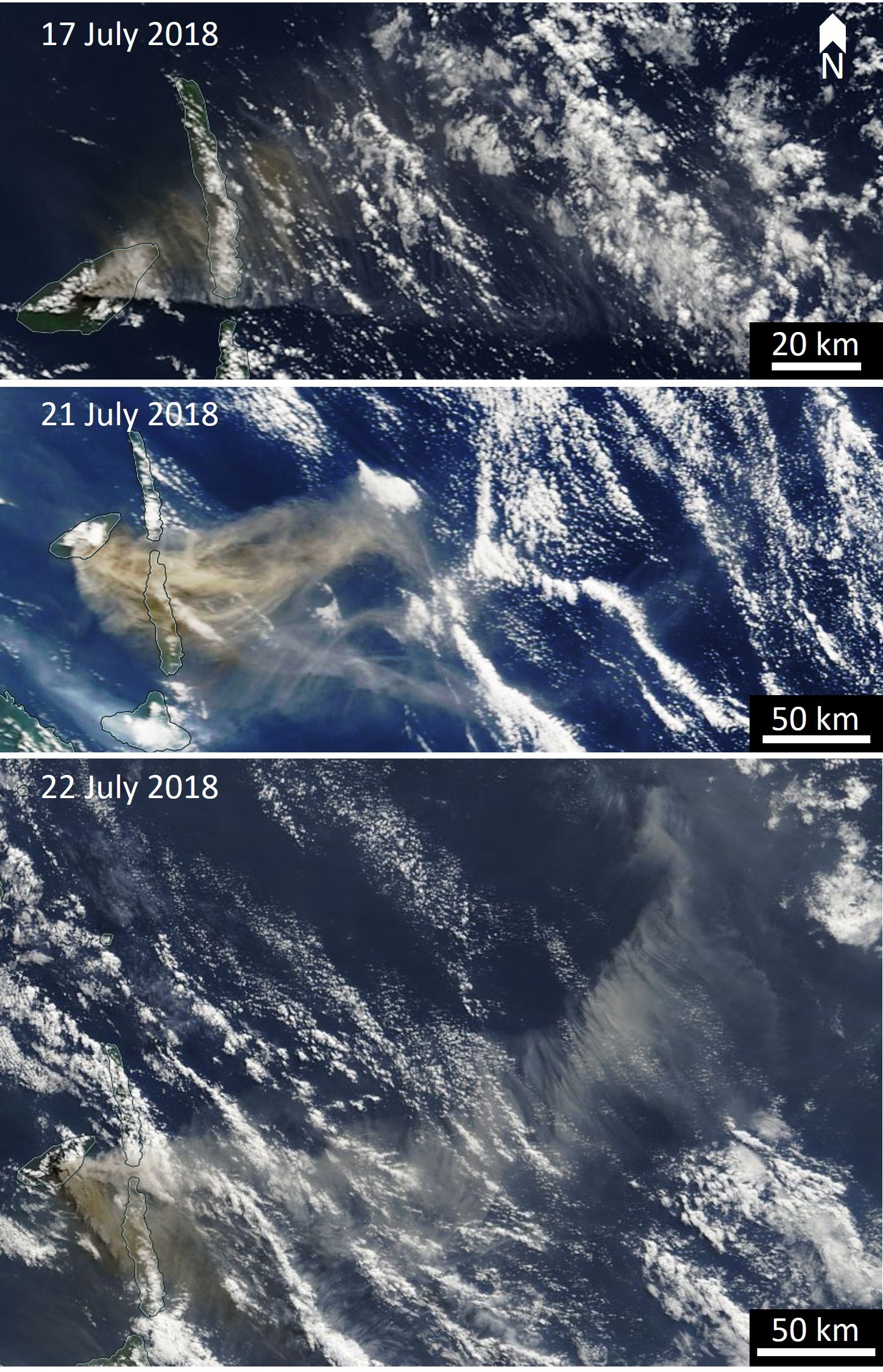
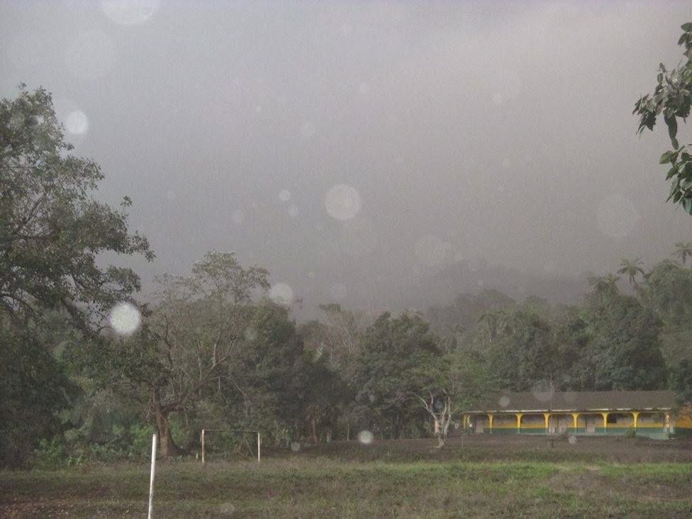
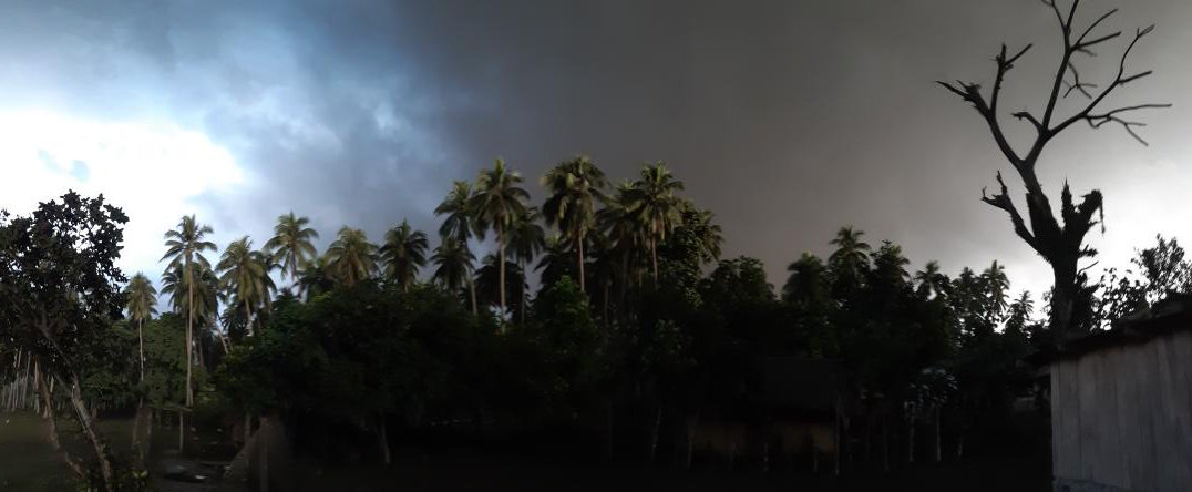
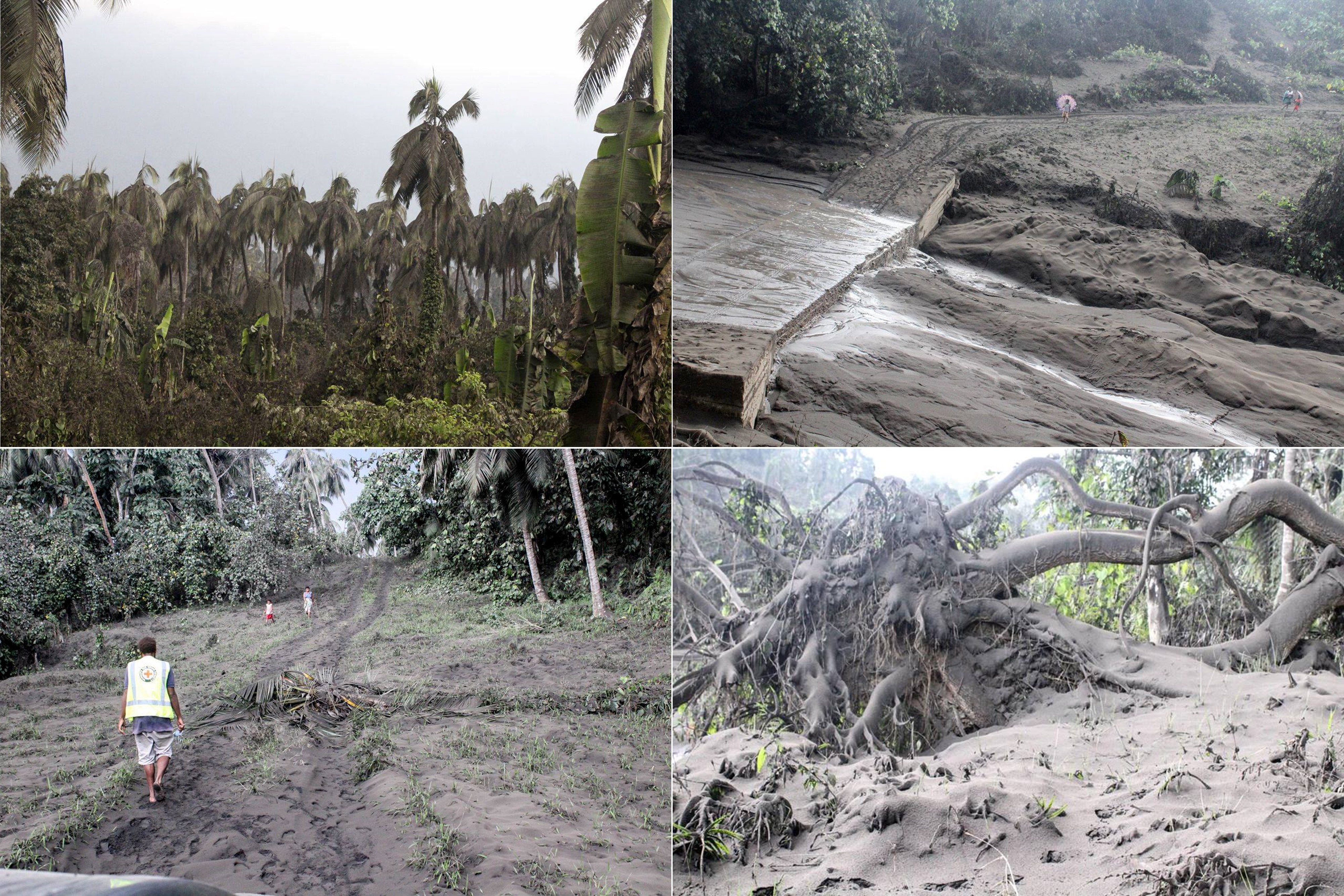
On 16 July the Darwin VAAC reported an ash plume to 9.1 km that drifted to the NE. During 16-24 July daily ash plumes from the Lake Voui vent rose to altitudes of 2.3-9.1 km and drifted N, NE, E, and SE (figure 79 and 80). Radio New Zealand reported that on the 16th significant ash emission blocked out sunlight, making the underlying area dark at around 1600 local time. Much of E and N Ambae Island experienced heavy ashfall and the eruption could be heard over 30 km away. The Vanuatu Red Cross Society reported worsening conditions in the south on 24 July with ashfall resulting in trees falling and very poor visibility of less than 2 m (figures 81, 82, and 83). The Daily Post reported that by 19 July lahars had washed away two roads and other roads were blocked to western Ambae. Volcanologists who made their way to the area reported widespread damage (figure 84). The Alert Level was raised from level 2 to 3 (on a scale of 0-5) on 21 July due to an increase in ash emission and more sustained plumes, similar to March 2018 activity.
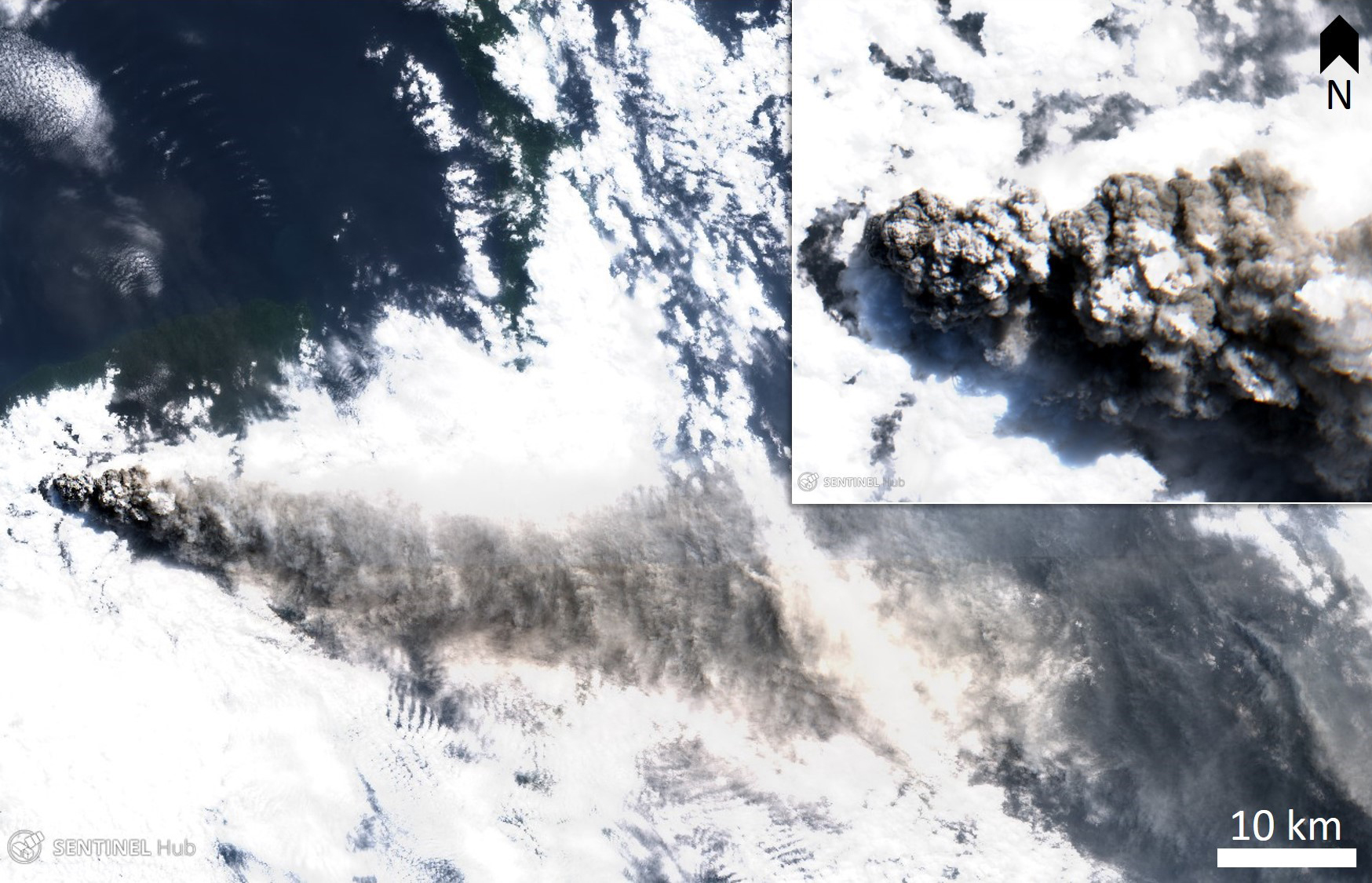
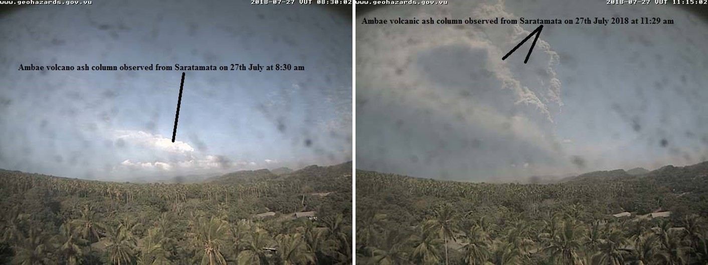
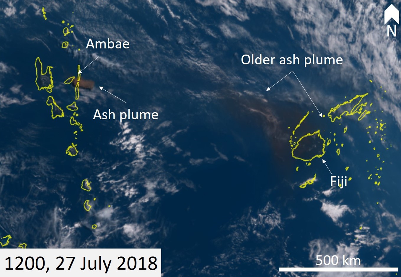
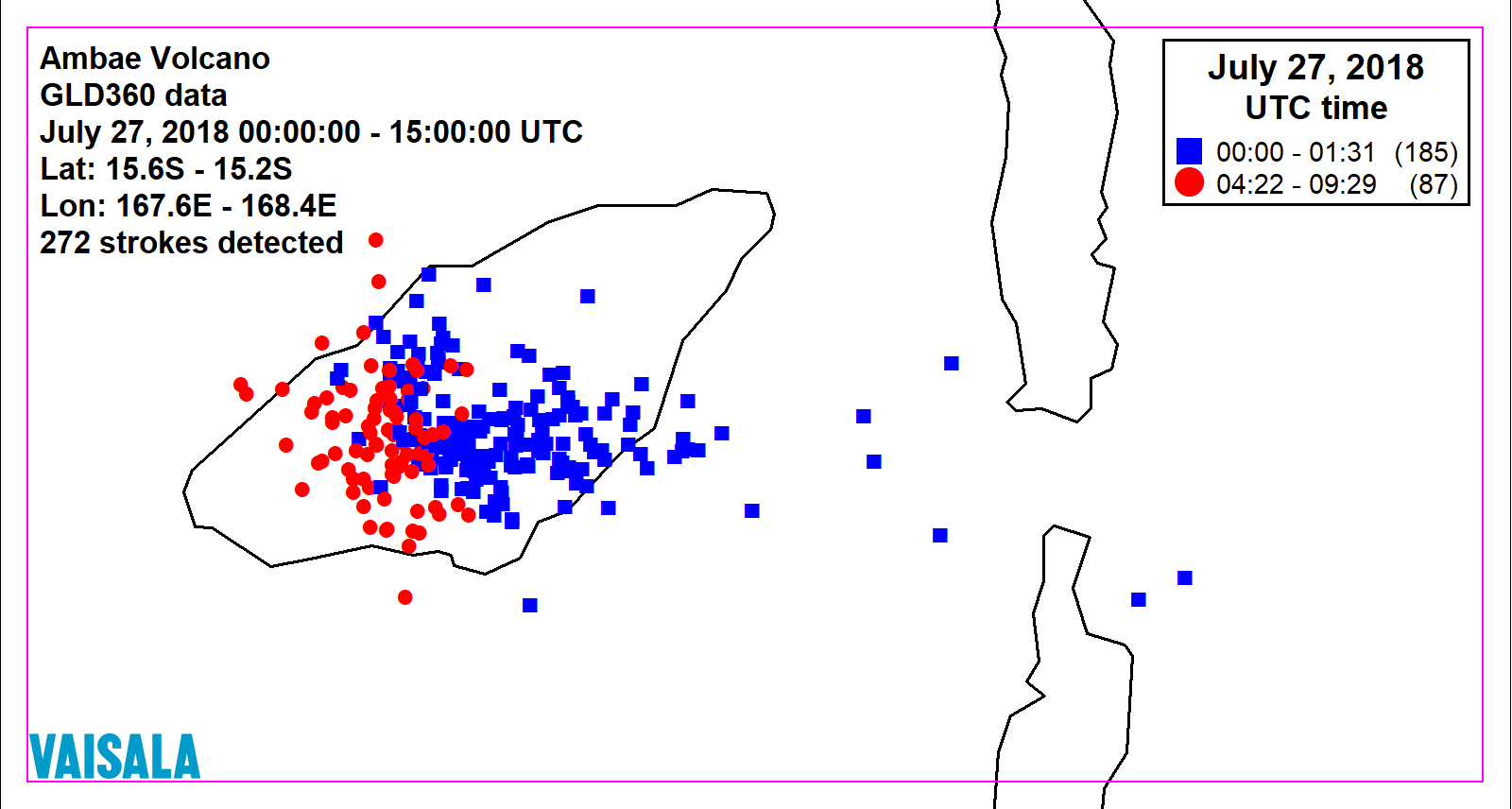
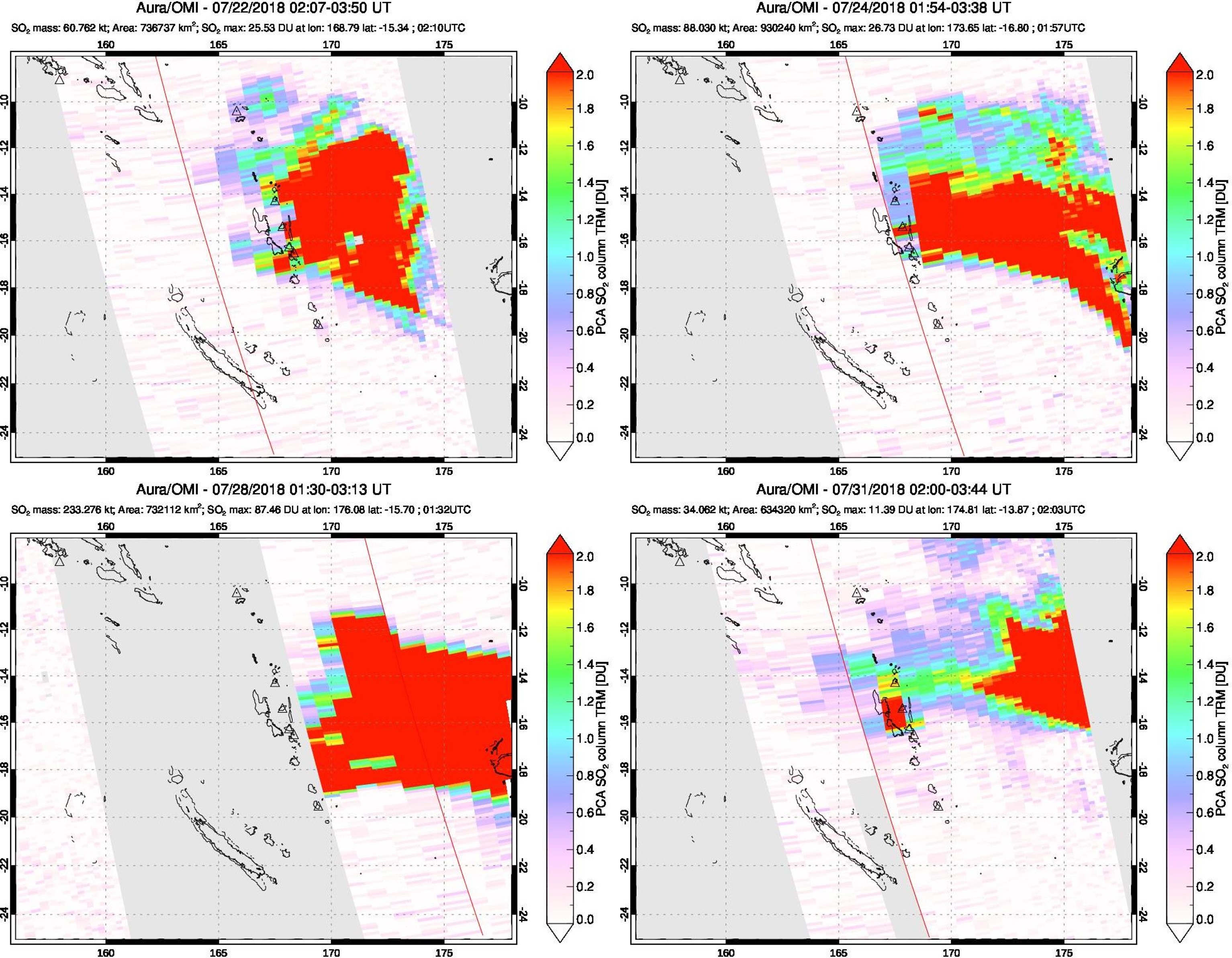
At 2100 on 26 July the ongoing explosions produced an ash plume that rose to 12 km and spread NE, E, SE. A state of emergency was announced by the Government of Vanuatu with a call for mandatory evacuations of the island. Ash emissions continued through the next day (figure 85 and 86) with two episodes producing volcanic lightning at 1100-1237 and 1522-2029 on 27 July (figure 87). The Darwin VAAC reported ash plumes up to 2.4-6.4 km, drifting SE and NW, and pilots reported heavy ashfall in Fiji. Large SO2 plumes were detected accompanying the eruptions and moving towards the E (figure 88).
Video footage showed a lahar blocking a road around 2 August. The government of Vanuatu told reporters that the island had been completely evacuated by 14 August. A VMGD bulletin on 22 August reported that activity continued with ongoing gas-and-steam and sometimes ash emissions; residents on neighboring islands could hear the eruption, smell volcanic gases, and see the plumes.
On 1 September at 2015 an explosion sent an ash plume to 4-11 km altitude, drifting E. Later observations in September showed a decrease in activity with no further explosions and plumes limited to white gas-and-steam plumes. On 21 September VMGD reported that the Lake Voui eruption had ceased and the Alert Level was lowered to 2.
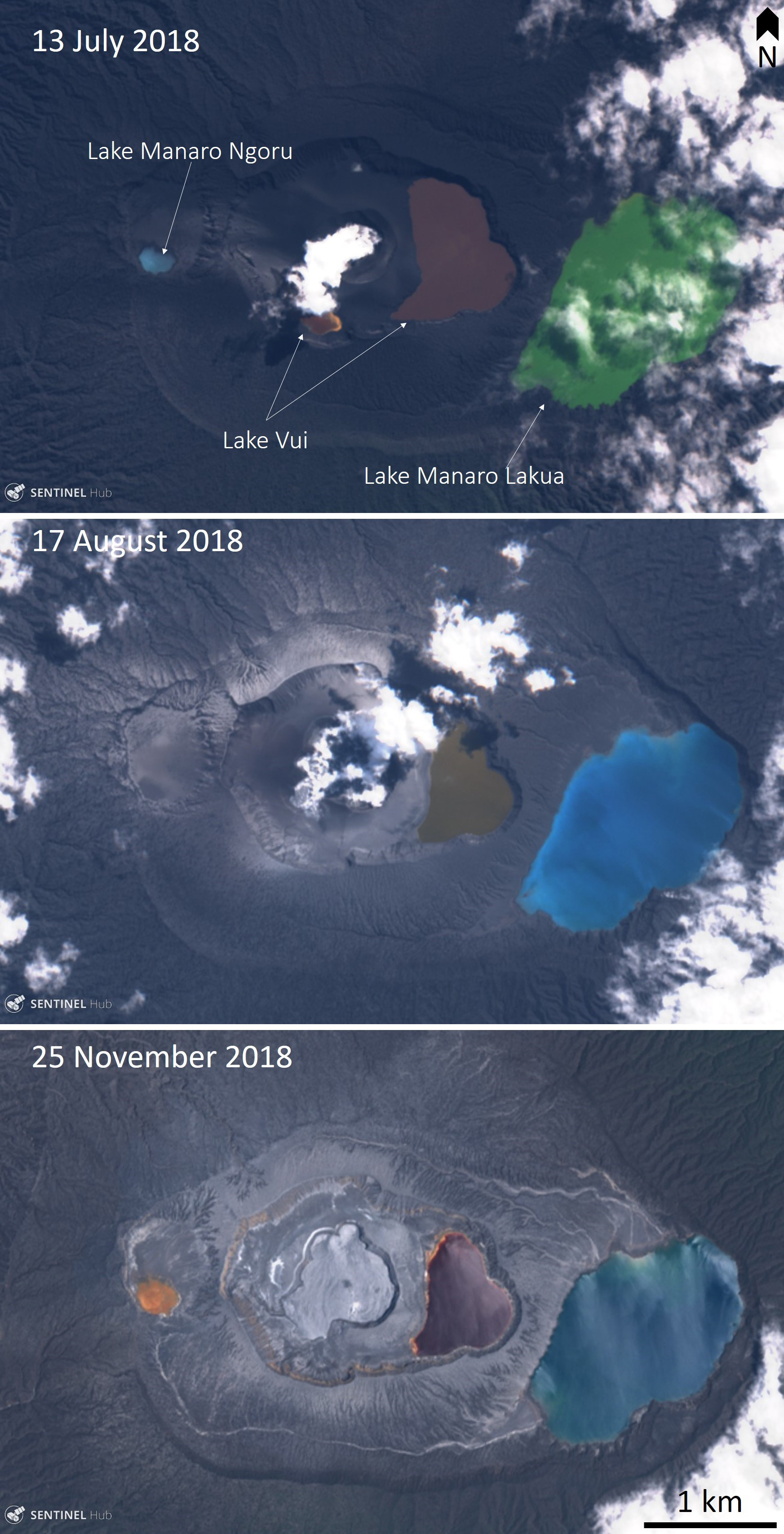
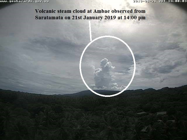
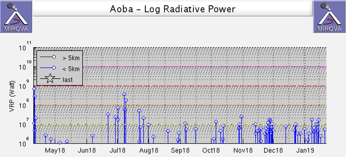
Observed activity through October and November dominantly consisted of white gas-and-steam plumes. An explosion on 30 October at 1832 produced an ash plume that rose to 4-5 km and drifted E and SE. Satellite images acquired during July-November show the changing crater area and crater lake water color (figure 89). VMGD volcano alert bulletins on 6, 7, and 21 January 2019 reported that activity continued with gas-and-steam emissions (figure 90). Thermal energy continued to be detected by the MIROVA system through January (figure 91).
Geological Summary. The island of Ambae, also known as Aoba, is a massive 2,500 km3 basaltic shield that is the most voluminous volcano of the New Hebrides archipelago. A pronounced NE-SW-trending rift zone with numerous scoria cones gives the 16 x 38 km island an elongated form. A broad pyroclastic cone containing three crater lakes (Manaro Ngoru, Voui, and Manaro Lakua) is located at the summit within the youngest of at least two nested calderas, the largest of which is 6 km in diameter. That large central edifice is also called Manaro Voui or Lombenben volcano. Post-caldera explosive eruptions formed the summit craters about 360 years ago. A tuff cone was constructed within Lake Voui (or Vui) about 60 years later. The latest known flank eruption, about 300 years ago, destroyed the population of the Nduindui area near the western coast.
Information Contacts: Geo-Hazards Division, Vanuatu Meteorology and Geo-Hazards Department (VMGD), Ministry of Climate Change Adaptation, Meteorology, Geo-Hazards, Energy, Environment and Disaster Management, Private Mail Bag 9054, Lini Highway, Port Vila, Vanuatu (URL: http://www.vmgd.gov.vu/, https://www.facebook.com/VanuatuGeohazardsObservatory/); Wellington Volcanic Ash Advisory Centre (VAAC), Meteorological Service of New Zealand Ltd (MetService), PO Box 722, Wellington, New Zealand (URL: http://www.metservice.com/vaac/, http://www.ssd.noaa.gov/VAAC/OTH/NZ/messages.html); Global Sulfur Dioxide Monitoring Page, Atmospheric Chemistry and Dynamics Laboratory, NASA Goddard Space Flight Center (NASA/GSFC), 8800 Greenbelt Road, Goddard, Maryland, USA (URL: https://so2.gsfc.nasa.gov/); NASA Worldview (URL: https://worldview.earthdata.nasa.gov/); Sentinel Hub Playground (URL: https://www.sentinel-hub.com/explore/sentinel-playground); MIROVA (Middle InfraRed Observation of Volcanic Activity), a collaborative project between the Universities of Turin and Florence (Italy) supported by the Centre for Volcanic Risk of the Italian Civil Protection Department (URL: http://www.mirovaweb.it/); Himawari-8 Real-time Web, developed by the NICT Science Cloud project in NICT (National Institute of Information and Communications Technology), Japan, in collaboration with JMA (Japan Meteorological Agency) and CEReS (Center of Environmental Remote Sensing, Chiba University) (URL: https://himawari8.nict.go.jp/); Vanuatu Red Cross Society (URL: https://www.facebook.com/VanuatuRedCross); William A. Brooks and Ronald L. Holle, Vaisala Inc., Tucson, Arizona, and Chris Vagasky, Vaisala Inc., Louisville, Colorado (URL: https://www.vaisala.com/); Michael Rowe, The University of Auckland, 23 Symonds Street, Auckland, 1010, New Zealand (URL: https://unidirectory.auckland.ac.nz/profile/michael-rowe); Radio New Zealand, 155 The Terrace, Wellington 6011, New Zealand (URL: https://www.radionz.co.nz/international/pacific-news/359231/vanuatu-provincial-capital-moves-due-to-volcano); Vanuatu Daily Post (URL: http://dailypost.vu/).