Krakatau
Indonesia
6.1009°S, 105.4233°E; summit elev. 285 m
All times are local (unless otherwise noted)
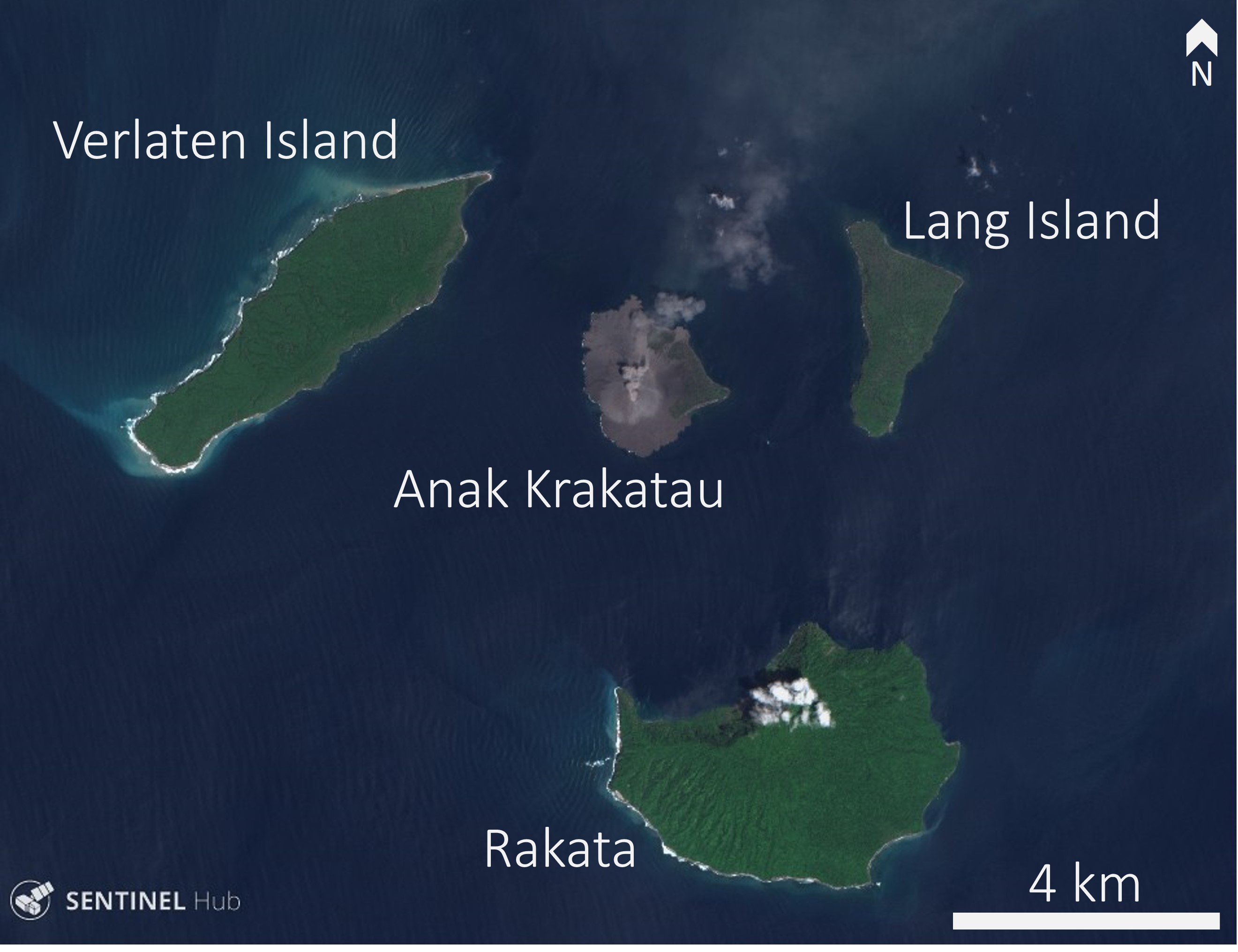
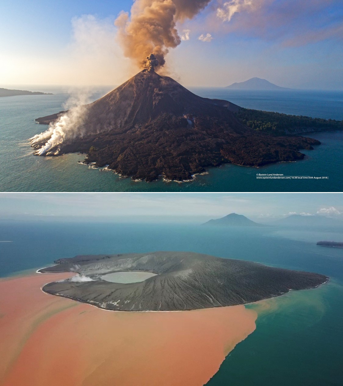
Krakatau volcano, between Java in Sumatra in the Sunda Straight of Indonesia, is known for its catastrophic collapse in 1883 that produced far-reaching pyroclastic flows, ashfall, and tsunami. The pre-1883 edifice had grown within an even older collapse caldera that formed around 535 CE, resulting in a 7-km-wide caldera and the three surrounding islands of Verlaten, Lang, and Rakata (figure 55). Eruptions that began in late December 1927 (figures 56 and 57) built the Anak Krakatau cone above sea level (Sudradjat, 1982; Simkin and Fiske, 1983). Frequent smaller eruptions since that time, over 40 short episodes consisting of ash plumes, incandescent blocks and bombs, and lava flows, constructed an island reaching 338 m elevation.
Historically there has been a lot of confusion about the name and preferred spelling of this volcano. Some have incorrectly made a distinction between the pre-1883 edifice being called "Krakatoa" and then using "Krakatau" for the current volcano. Anak Krakatau is the name of the active cone, but the overall volcano name is simply Krakatau. Simkin and Fiske (1983) explained as follows: "Krakatau was the accepted spelling for the volcano in 1883 and remains the accepted spelling in modern Indonesia. In the original manuscript copy submitted to the printers of the 1888 Royal Society Report, now in the archives of the Royal Society, this spelling has been systematically changed by a neat red line through the final 'au' and the replacement 'oa' entered above; a late policy change that, from some of the archived correspondence, saddened several contributors to the volume."
After 15 months of quiescence Krakatau began a new eruption phase on 21 June 2018, characterized by ash plumes, ballistic ejecta, Strombolian activity, and lava flows. Ash plumes reached 4.9 km and a lava flow traveled down the SE flank and entered the ocean. This report summarizes the activity from October 2018 to January 2019 based on reports by Pusat Vulkanologi dan Mitigasi Bencana Geologi (PVMBG), also known as the Indonesian Center for Volcanology and Geological Hazard Mitigation (CVGHM), MAGMA Indonesia, the National Board for Disaster Management - Badan Nasional Penanggulangan Bencana (BNPB), the Darwin Volcanic Ash Advisory Center (VAAC), satellite data, and eye witness accounts.
Activity during October-21 December 2018. The eruption continued to eject incandescent ballistic ejecta, ash plumes, and lava flows in October through December 2018. On 22 December a partial collapse of Anak Krakatau began, dramatically changing the morphology of the island and triggering a deadly tsunami that impacted coastlines around the Sunda Straight. Following the collapse the vent was located below sea level and Surtseyan activity produced steam plumes, ash plumes, and volcanic lightning.
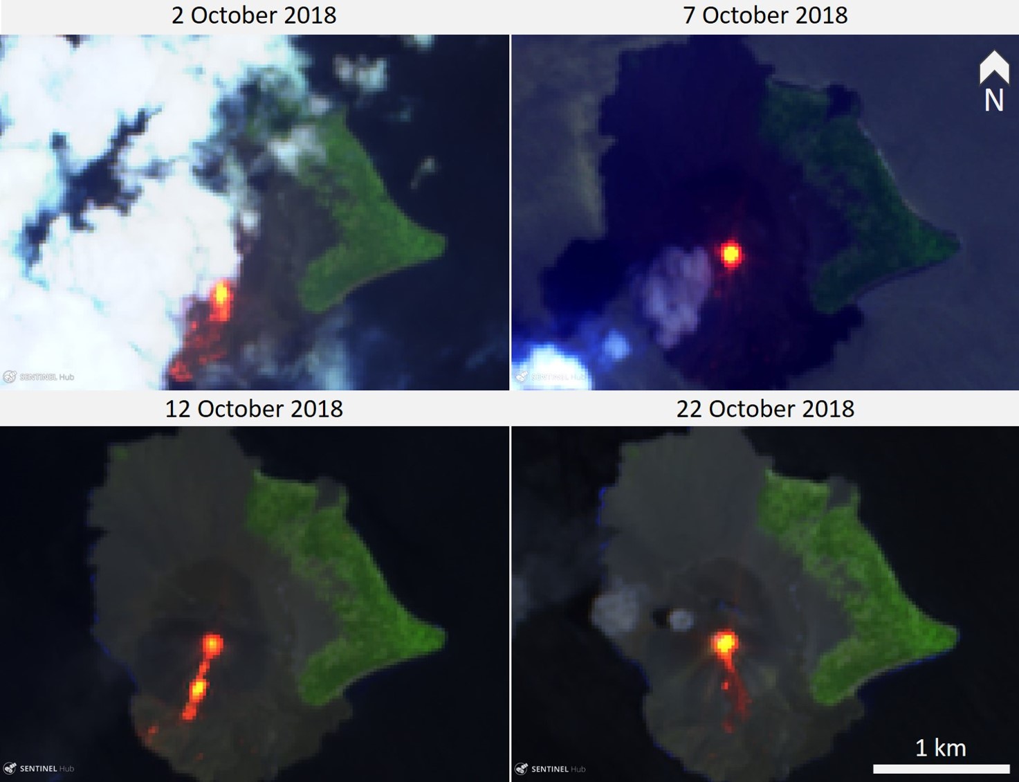
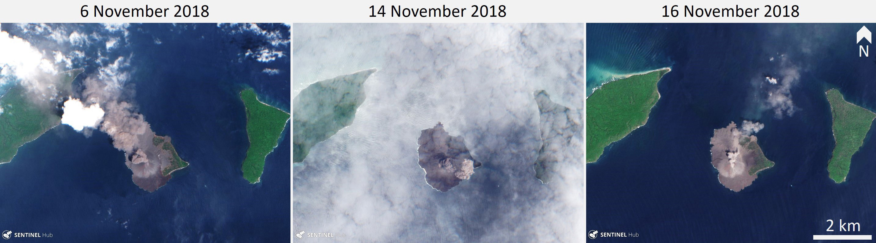
Sentinel-2 satellite images acquired through October show incandescence in the crater, lava flows on the SW flank, and incandescent material to the S to SE of the crater (figure 58). This correlates with eyewitness accounts of explosions ejecting incandescent ballistic ejecta, and Volcano Observatory Notice for Aviation (VONA) ash plume reports. The Darwin VAAC reported ash plumes to 1.5-2.4 km altitude that drifted in multiple directions during 17-19 October, but throughout most of October visual observations were limited due to fog. A video shared by Sutopo on 24 October shows ash emission and lava fountaining producing a lava flow that entered the ocean, resulting in a white plume. Video by Richard Roscoe of Photovolcanica shows explosions ejecting incandescent blocks onto the flanks and ash plumes accompanied by volcanic lightning on 25 October.
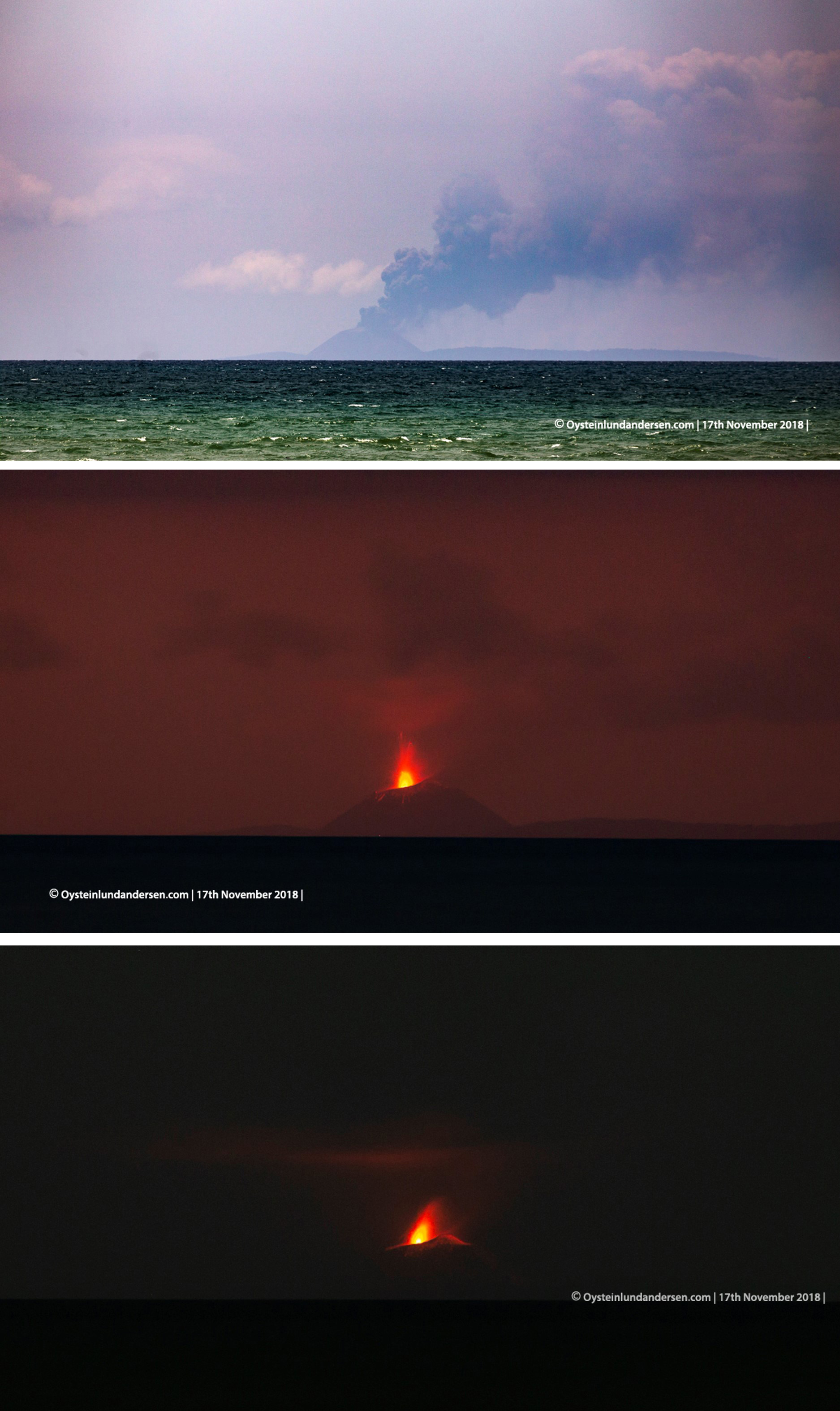
Throughout November frequent ash plumes rose to 0.3-1.3 km altitude, with explosion durations spanning 29-212 seconds (figure 59). Observations by Øystein Lund Andersen describe explosions ejecting incandescent material with ash plumes and some associated lightning on 17 November (figure 60).
During 1-21 December intermittent explosions lasting 46-776 seconds produced ash plumes that rose up to 1 km altitude. Thermal signatures were sporadically detected by various satellite thermal infrared sensors during this time. On 22 December ash plumes reached 0.3-1.5 km through the day and continuous tremor was recorded.
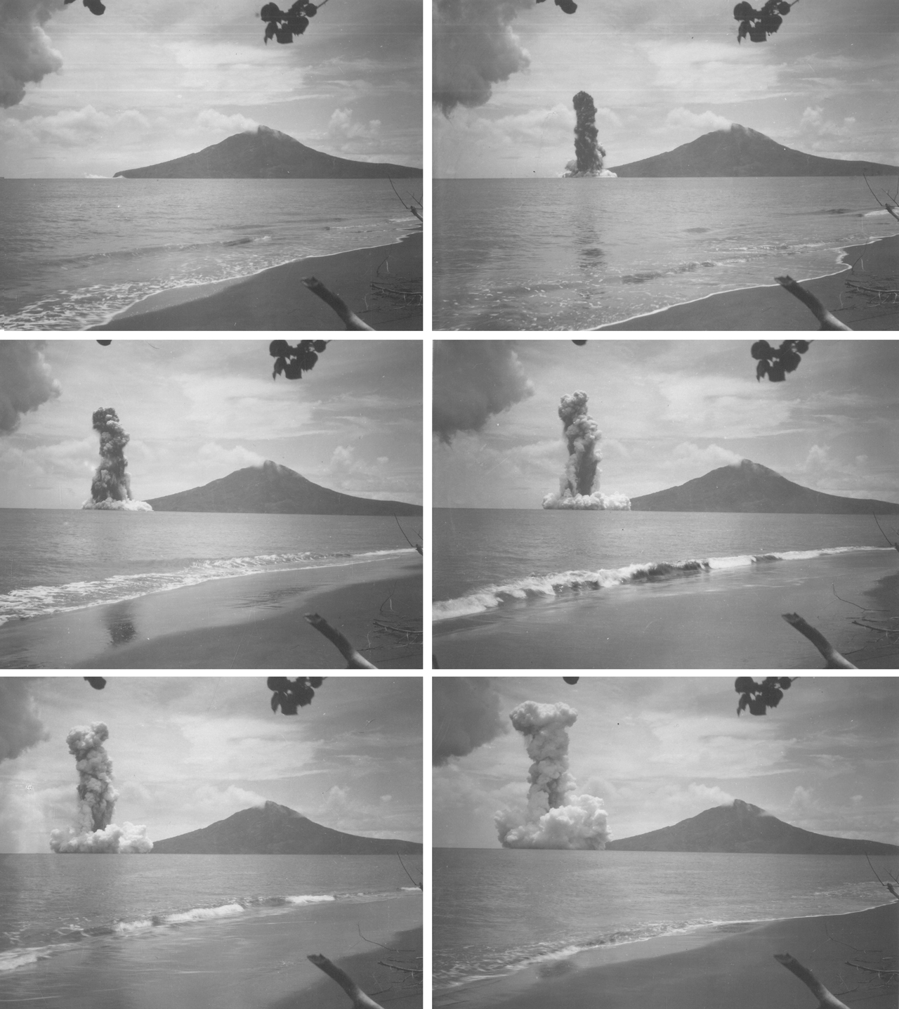
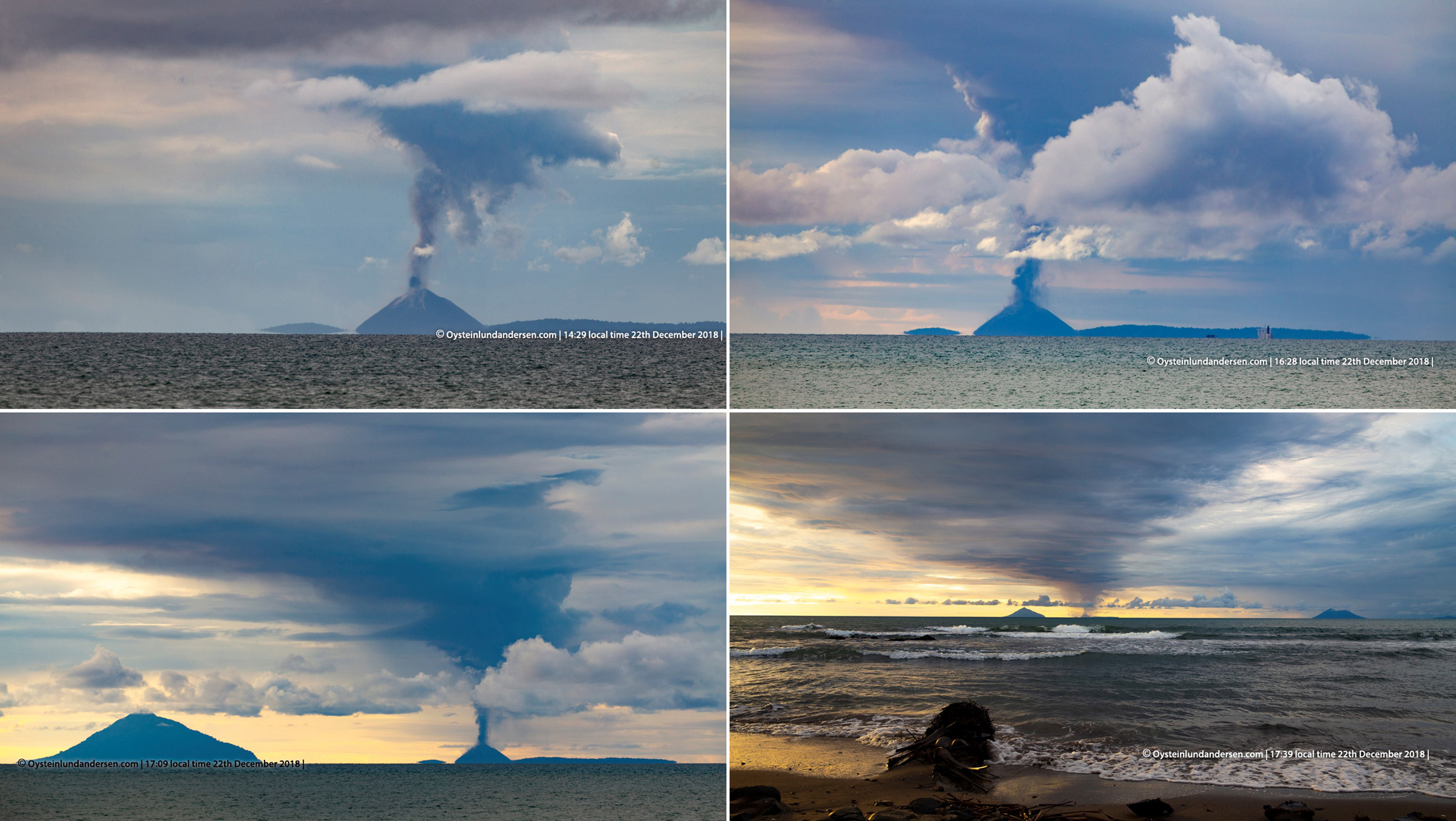
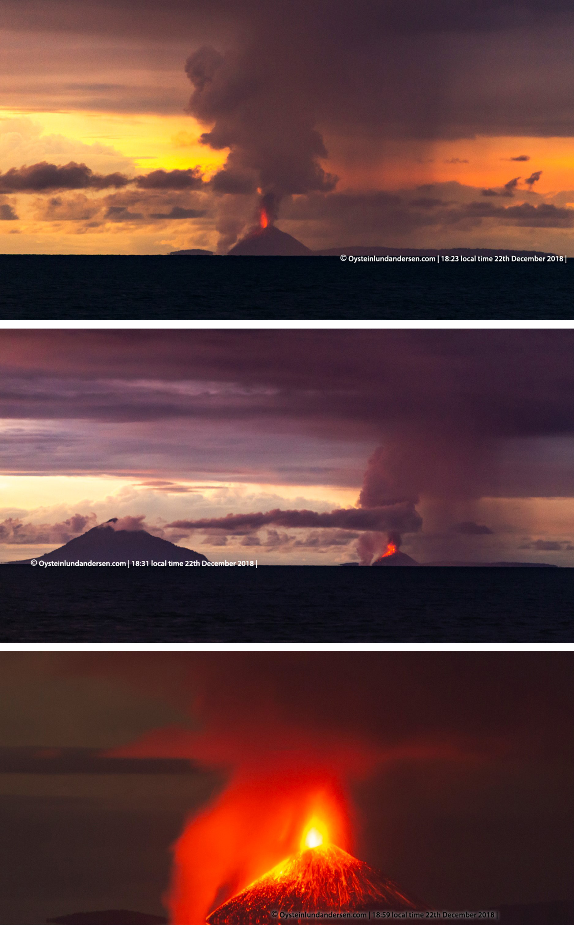
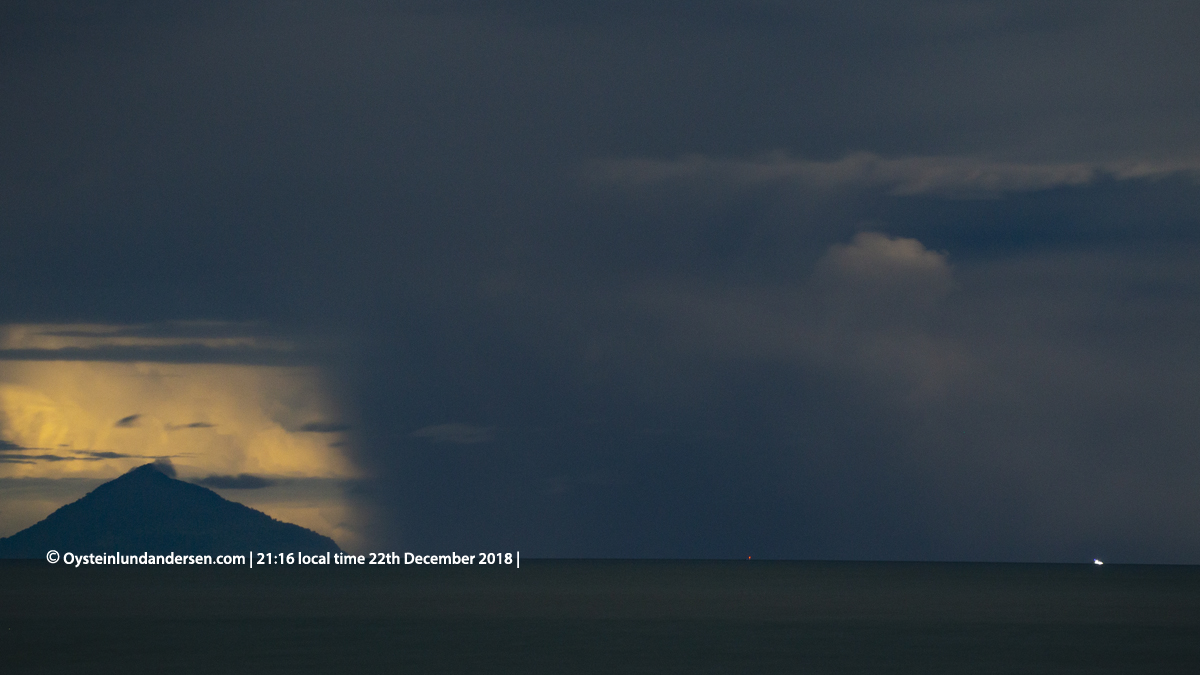
Activity and events during 22-28 December 2018. The following events during the evening of the 22nd were recorded by Øystein Lund Andersen, who was photographing the eruption from the Anyer-Carita area in Java, approximately 47 km from Anak Krakatau. Starting at 1429 local time, incandescence and ash plumes were observed and the eruption could be heard as intermittent 'cannon-fire' sounds, sometimes shaking walls and windows. An increase in intensity was noted at around 1700, when the ash column increased in height and was accompanied by volcanic lightning, and eruption sounds became more frequent (figure 61). A white steam plume began to rise from the shore of the southern flank. After sunset incandescent ballistic blocks were observed impacting the flanks, with activity intensity peaking around 1830 with louder eruption sounds and a higher steam plume from the ocean (figure 62).
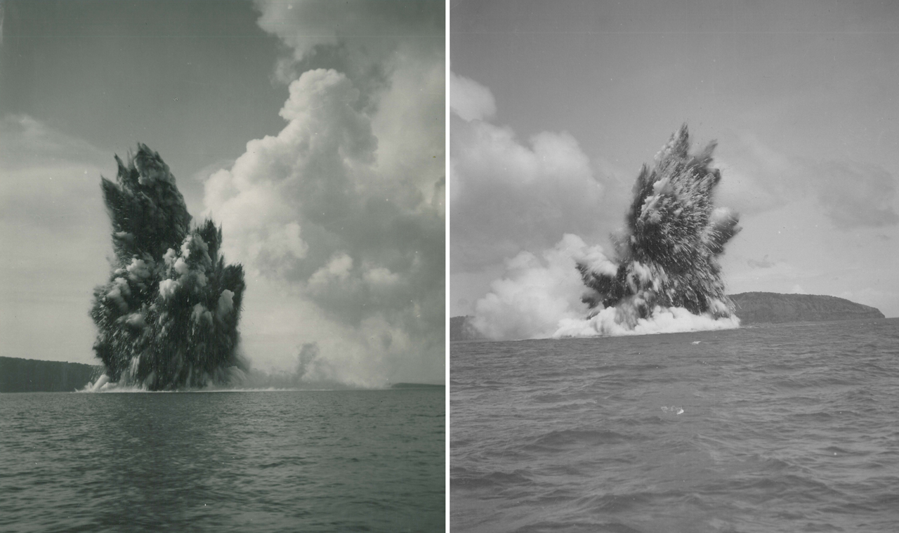
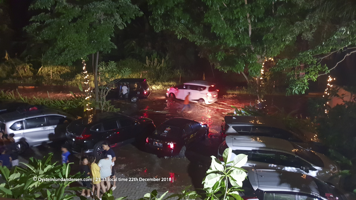
PVMBG recorded an eruption at 2103. When viewed at 2105 by Øystein Lund Andersen, a dark plume across the area blocked observations of Anak Krakatau and any incandescence (figure 63). At 2127-2128 the first tsunami wave hit the shore and traveled approximately 15 m inland (matching the BNPB determined time of 2127). At approximately 2131 the sound of the ocean ceased and was soon replaced by a rumbling sound and the second, larger tsunami wave impacted the area and traveled further inland, where it reached significant depths and caused extensive damage (figures 64 and 65). After the tsunami, eruption activity remained high and the eruption was heard again during intervals from 0300 through to early afternoon.
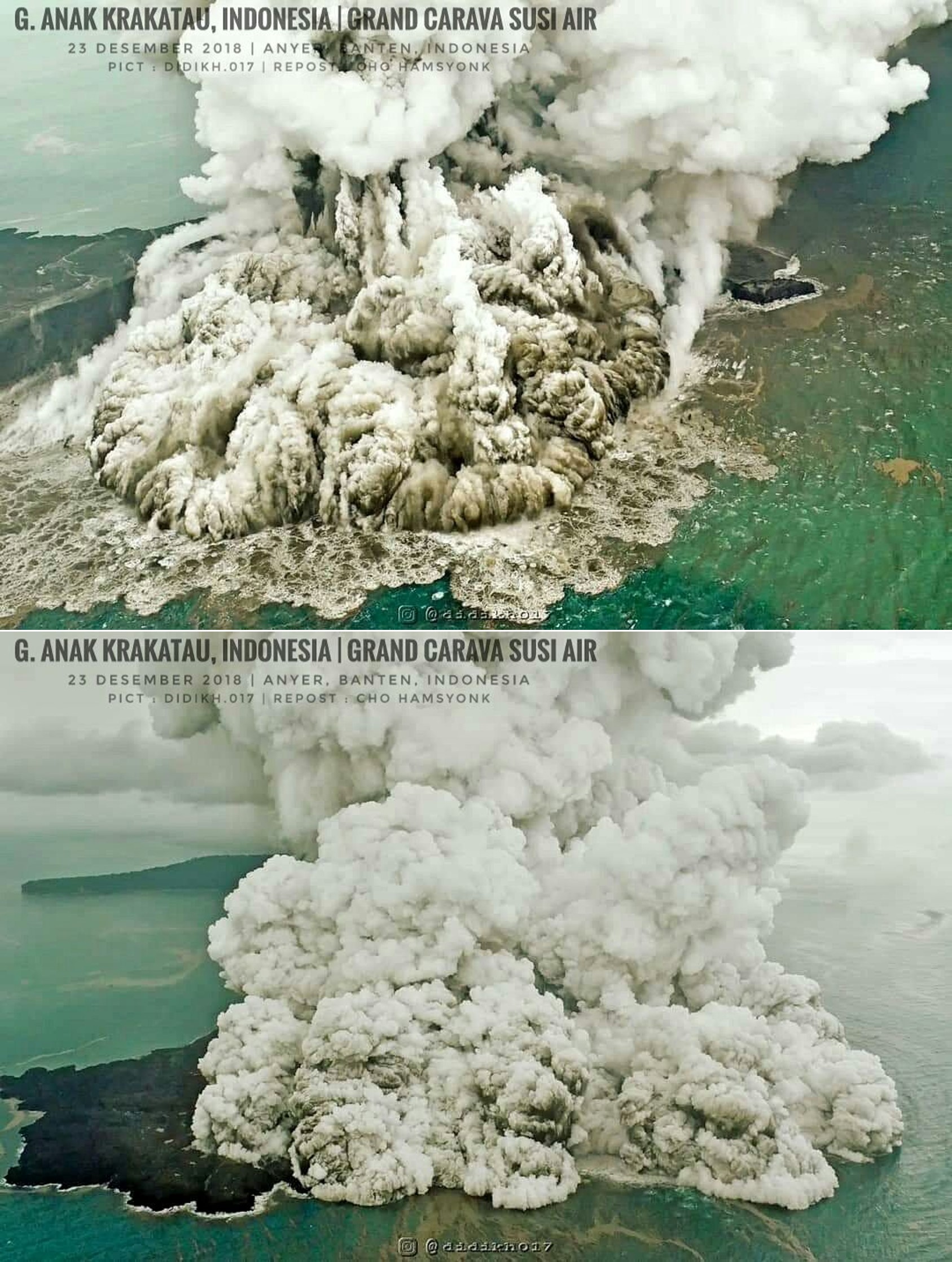
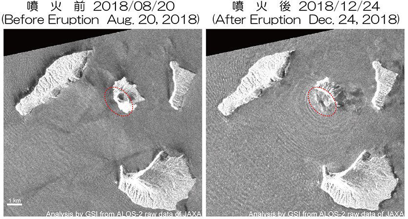
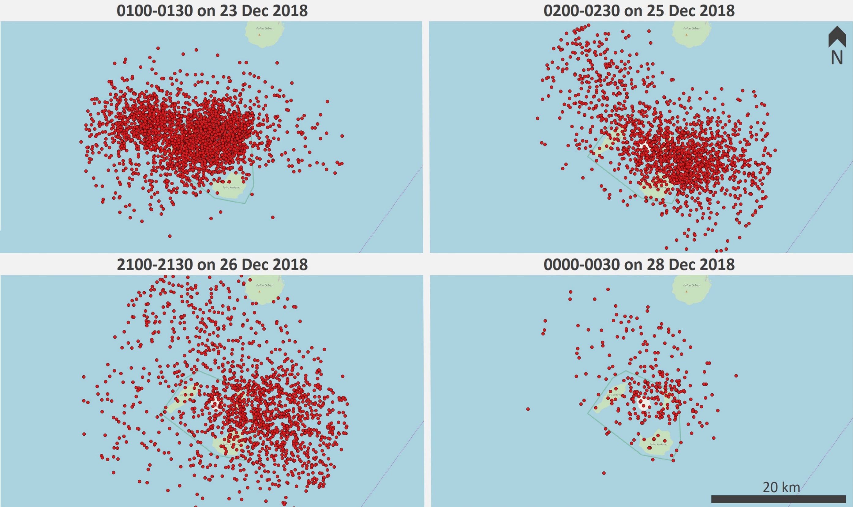
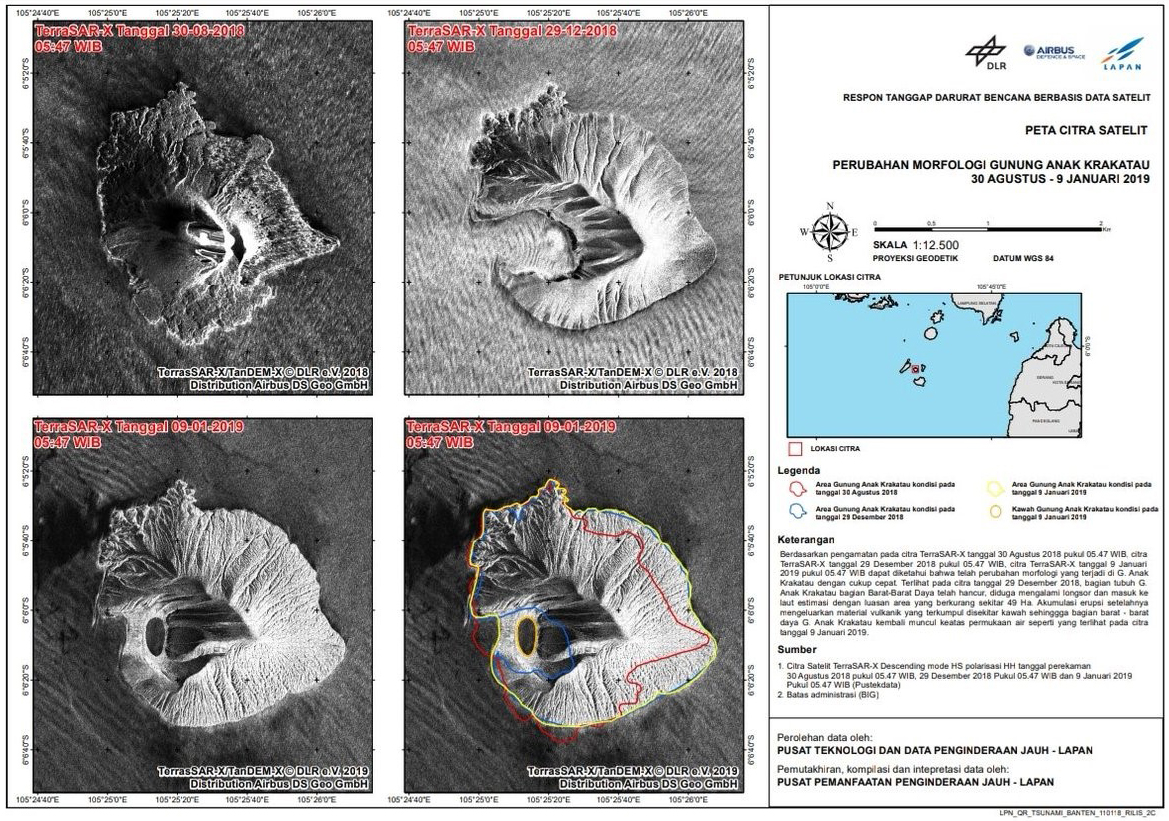
Observations on 23 December reveal steam-rich ash plumes and base surge traveling along the water, indicative of the shallow-water Surtseyan eruption (figure 66). Ashfall was reported on the 26th in several regions including Cilegon, Anyer, and Serang. The first radar observations of Krakatau were on 24 December and showed a significant removal of material from the island (figure 67). At 0600 on the 27th the volcanic alert level was increased from II to III (on a scale of I-IV) and a VONA with Aviation Color Code Red reported an ash plume to approximately 7 km altitude that dispersed to the NE. When Anak Krakatau was visible, Surtseyan activity and plumes were observed through the end of December. On 28 December, plumes reached 200-3000 m. At 0418 the eruption paused and the first observation of the post-collapse edifice was made. The estimated removed volume (above sea level) was 150-180 million m3, leaving a remaining volume of 40-70 million m3. The summit of the pre-collapse cone was 338 m, while the highest point post-collapse was reduced to 110 m. Hundreds of thousands of lightning strokes were detected during 22-28 December with varying intensity (figure 68).
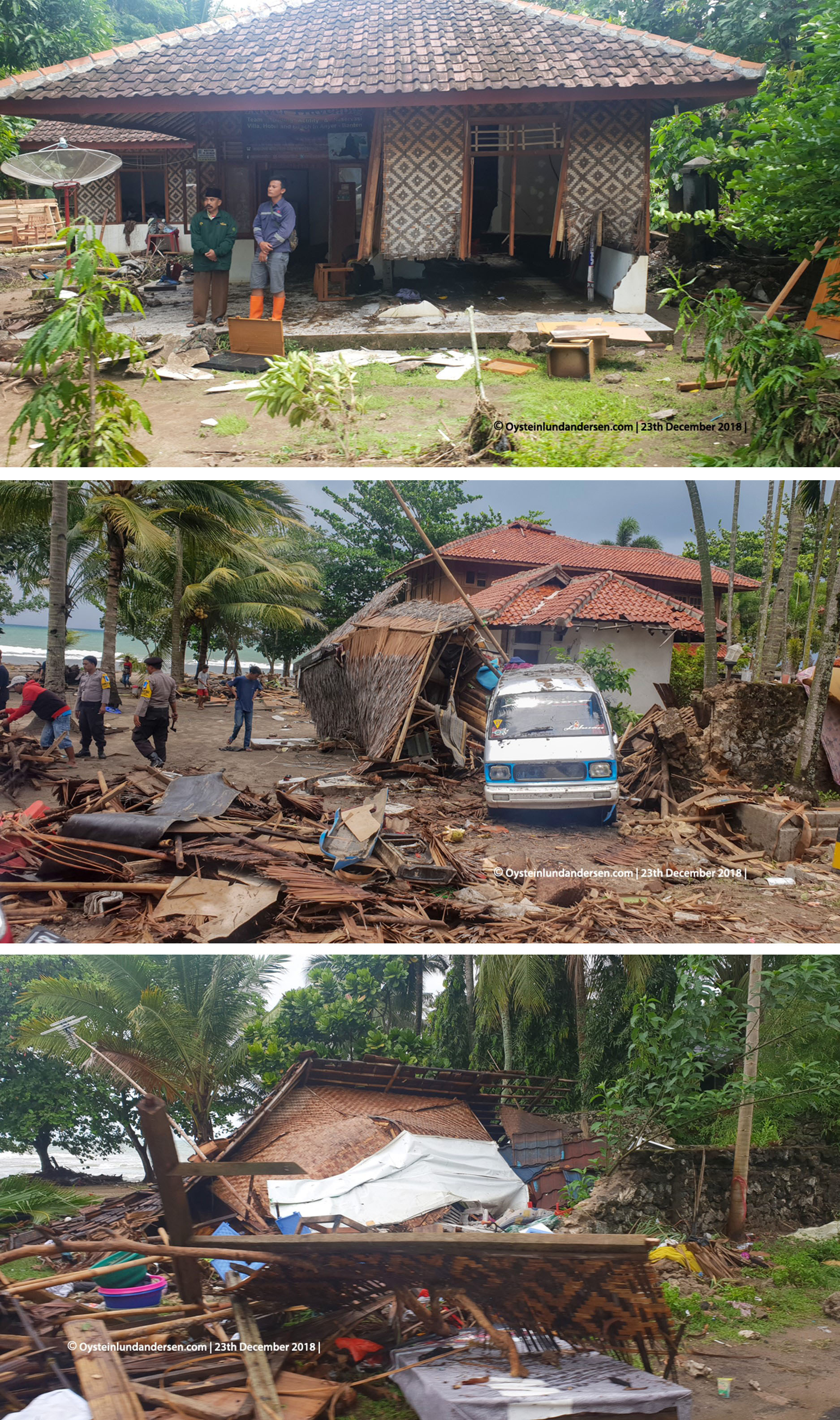
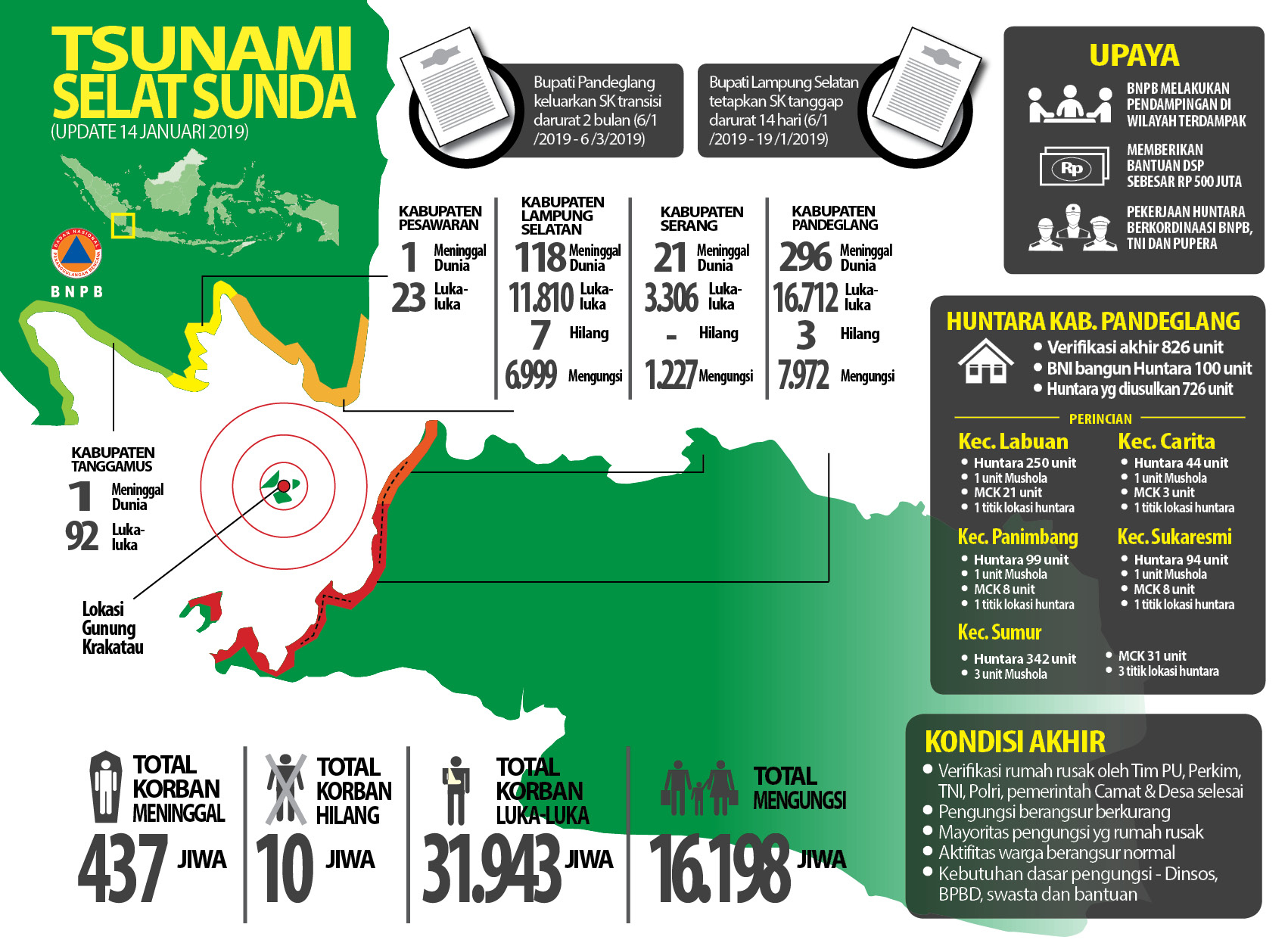
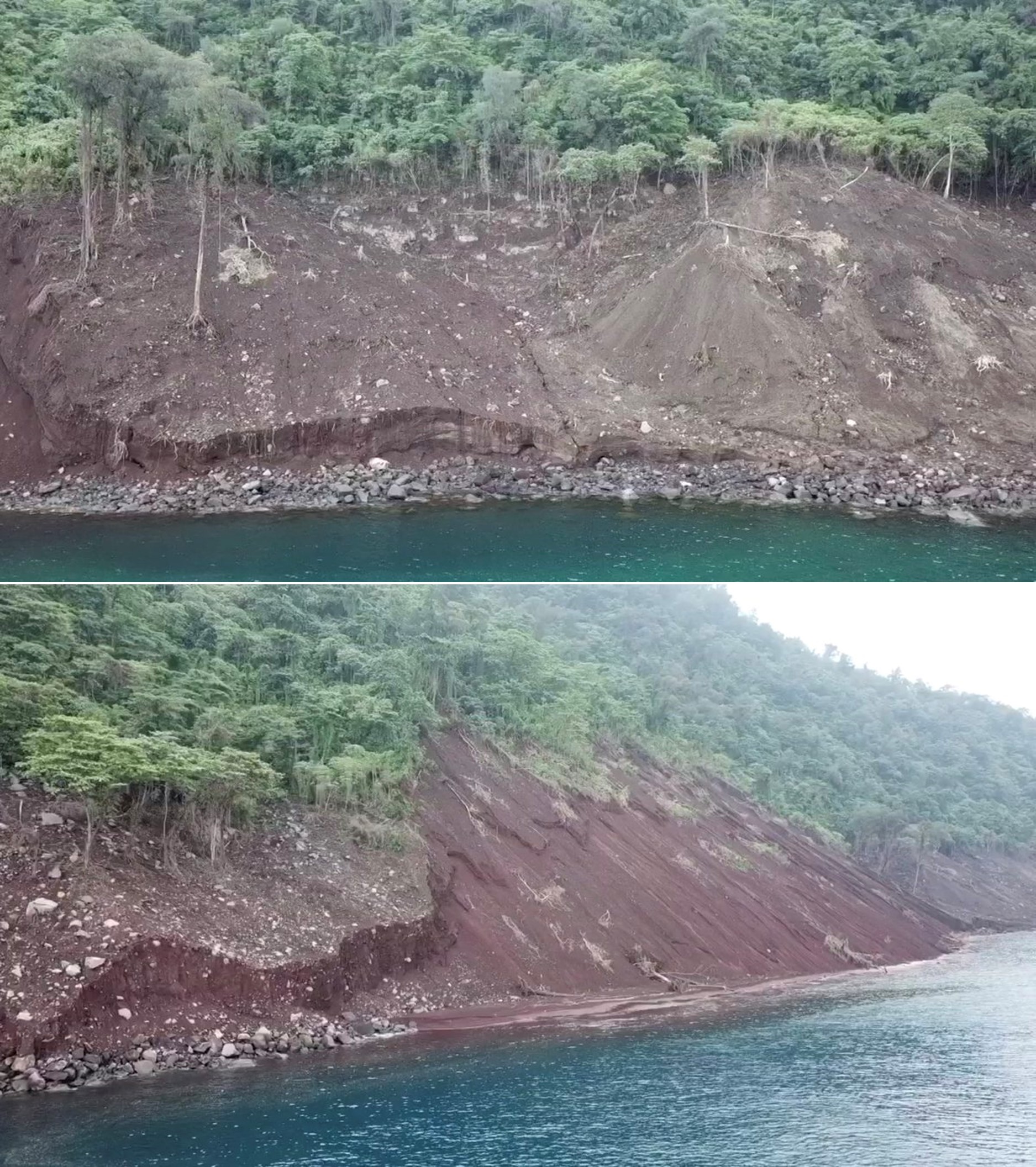
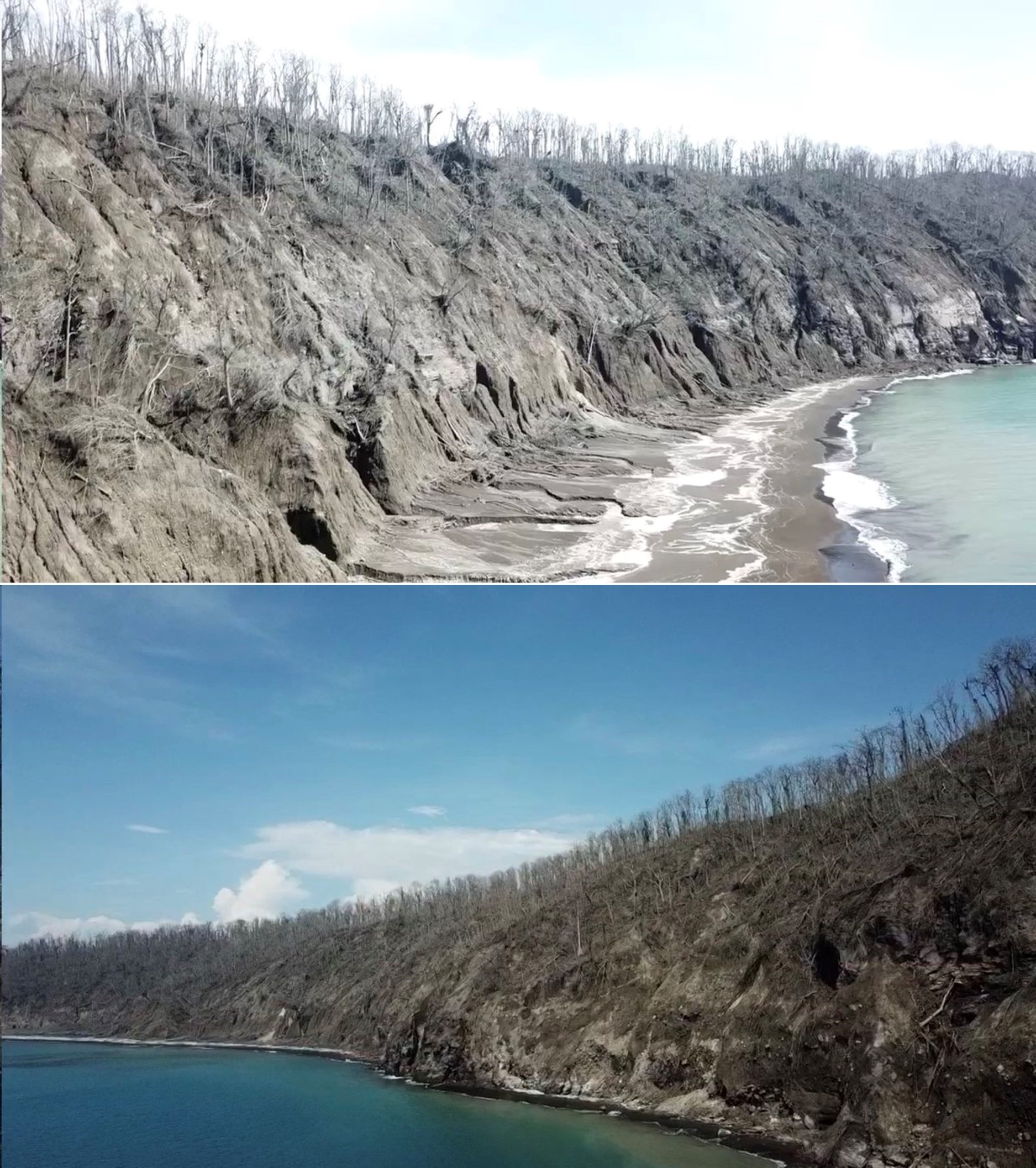
Damage resulting from the 22 December tsunami. On the 29 December the damage reported by BNPB was 1,527 heavily damaged housing units, 70 with moderate damage, 181 with light damage, 78 damaged lodging and warung units, 434 damaged boats and ships and some damage to public facilities. Damage was recorded in the five regencies of Pandenglang, Serang, South Lampung, Pesawaran and Tanggamus. A BNPB report on 14 January gave the following figures: 437 fatalities, 10 people missing, 31,943 people injured, and 16,198 people evacuated (figure 69). The eruption and tsunami resulted in damage to the surrounding islands, with scouring on the Anak-Krakatau-facing slope of Rakata and damage to vegetation on Kecil island (figure 70 and 71).
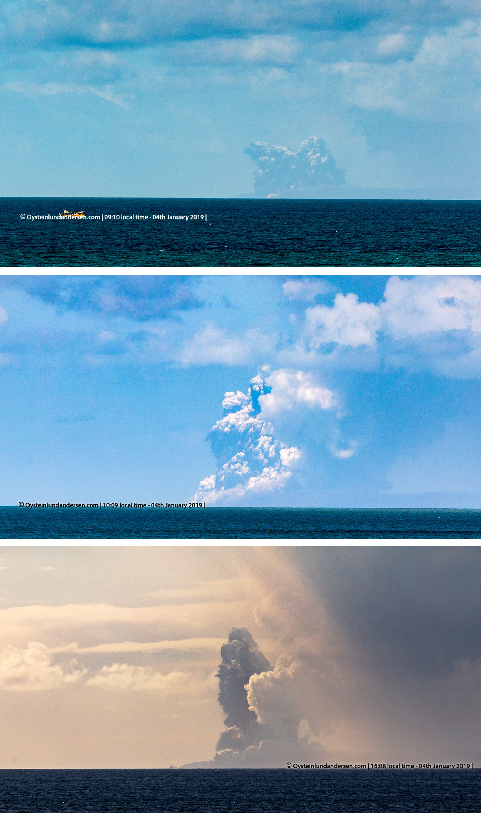
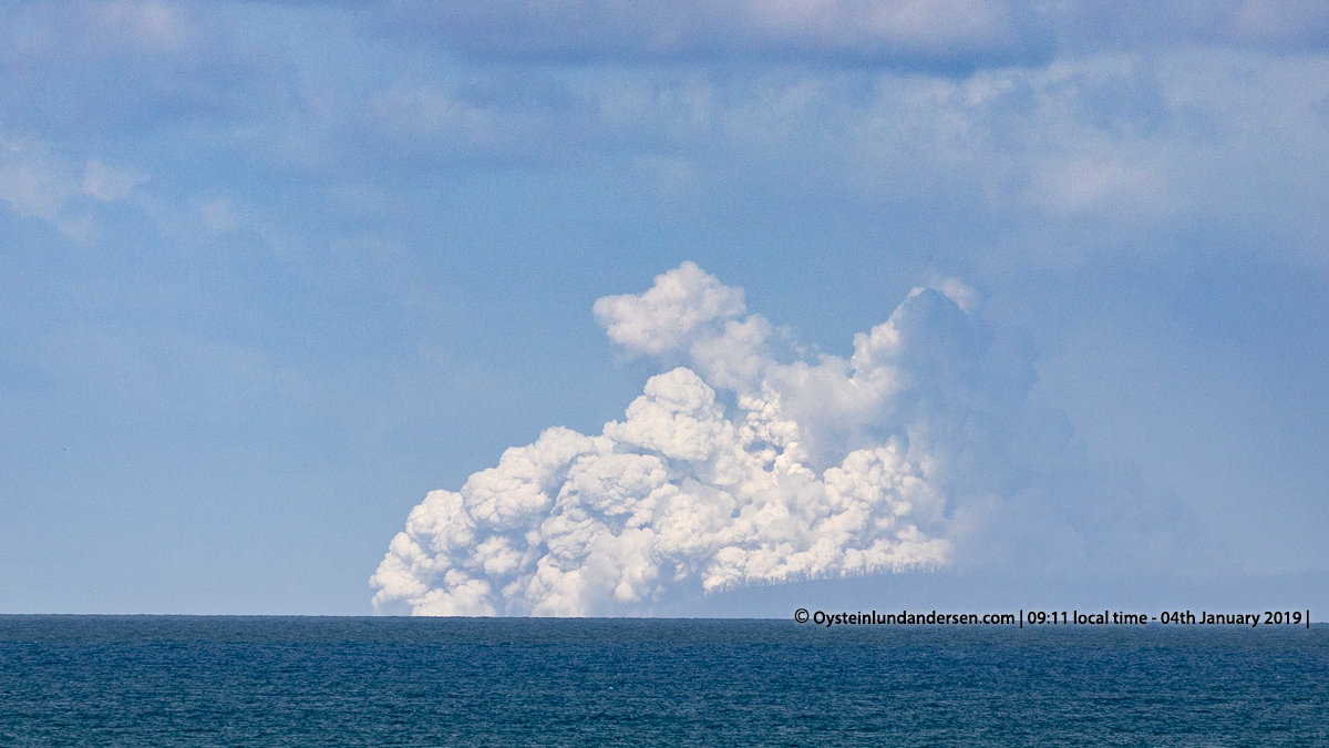
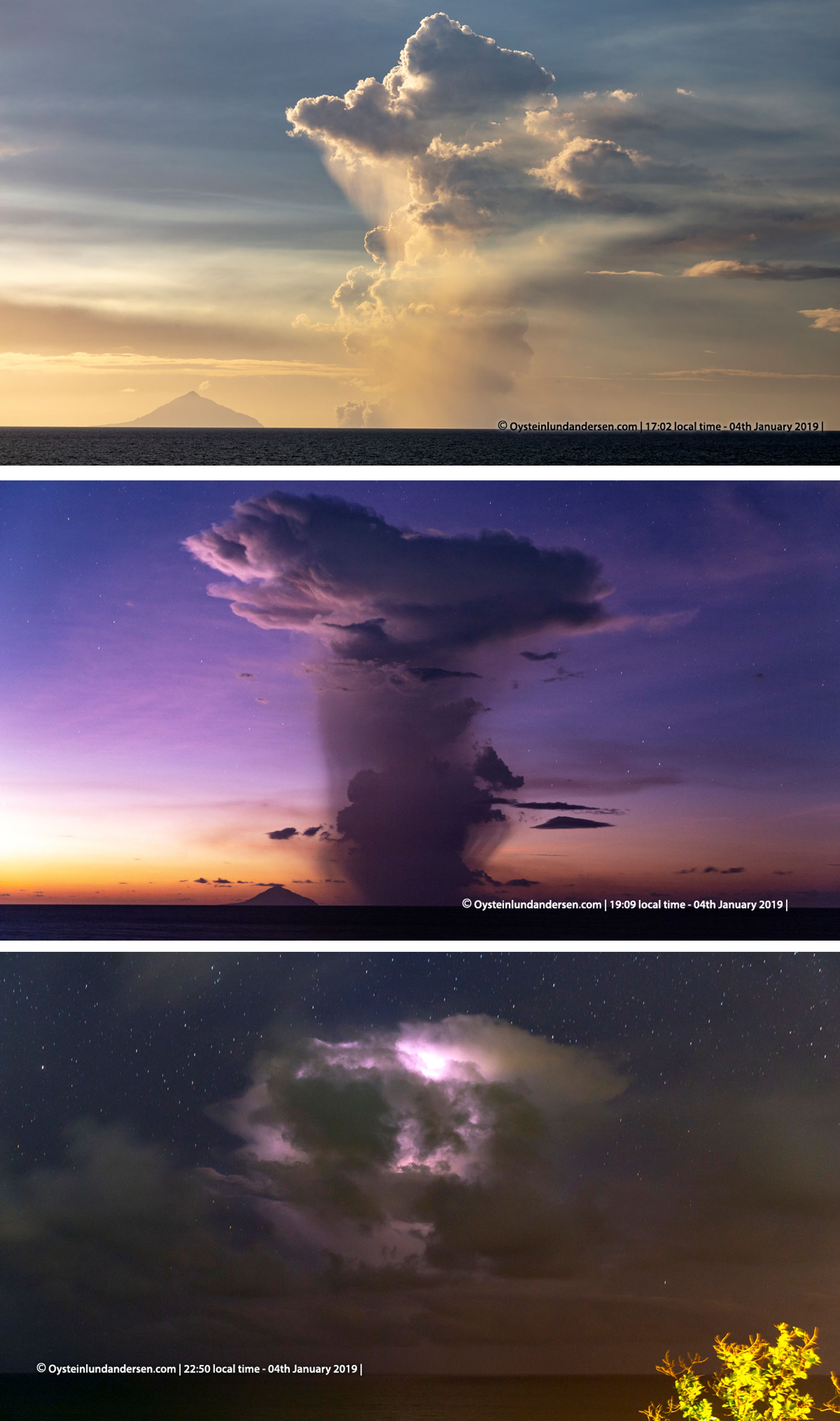
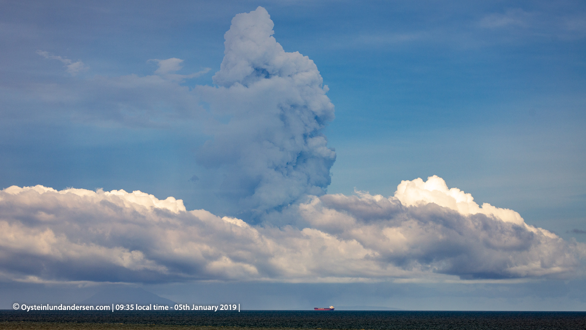
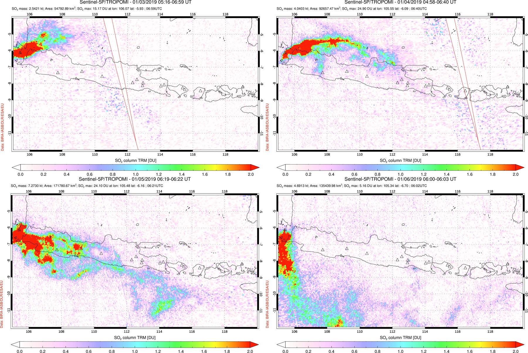
Activity during January 2019. Surtseyan activity continued into January 2019. Øystein Lund Andersen observed the eruption on 4-5 January. Activity on 4 January was near-continuous. The photographs show black cock's-tail jets that rose a few hundred meters before collapsing (figure 72), accompanied by white lateral base surge that spread from the vent across the ocean (figure 73), and white steam plumes that were visible from Anyer-Carita, West Java. In the evening the ash-and-steam plume was much higher (figure 74). It was also noted that older pumice had washed ashore at this location and a coating of sulfur was present along the beach and some of the water surface. Activity decreased again on the 5th (figure 75) with a VONA reporting an ash plume to 1.5 km towards the WSW. SO2 plumes were dispersed to the NE, E, and S during this time (figure 76).
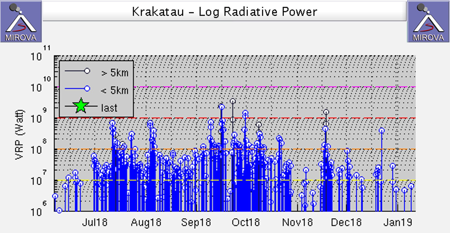
During 5-9 January intermittent explosions lasting 20 seconds to 13 minutes produced ash plumes rising up to 1.2 km and dispersing E. From 11 to 19 January white plumes were observed up to 500 m. Observations were prevented due to fog during 20-31 January. MIROVA thermal data show elevated thermal anomalies from July through January, with a decrease in energy in November through January (figure 77). The radiative power detected in December-January was the lowest since June 2018.
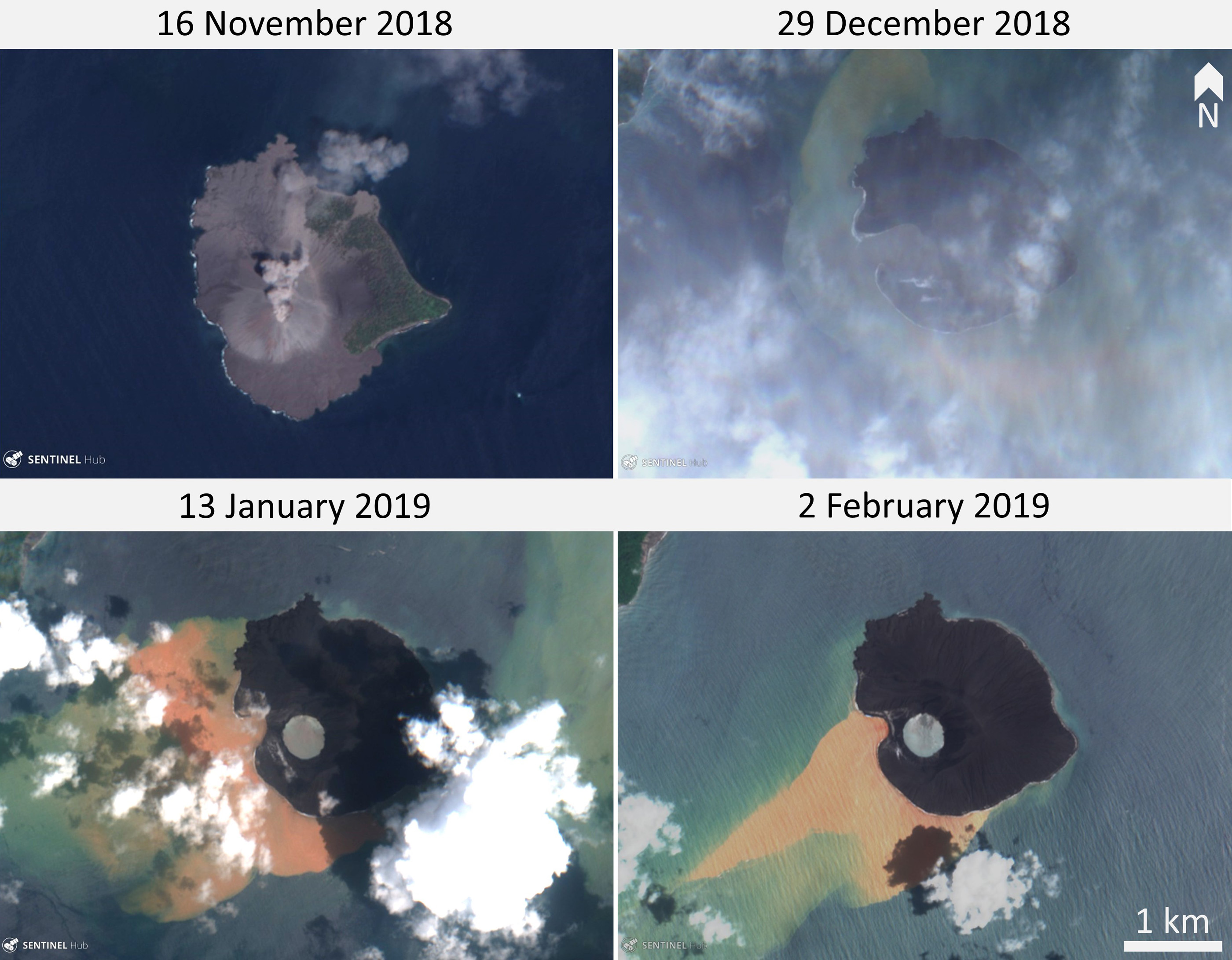
Morphological changes to Anak Krakatau. Images taken before and after the collapse event show changes in the shoreline, destruction of vegetation, and removal of the cone (figure 78). A TerraSAR-X image acquired on 29 January shows that in the location where the cone and active vent was, a bay had formed, opening to the W (figure 79). These changes are also visible in Sentinel-2 satellite images, with the open bay visible through light cloud cover on 29 December (figure 80).
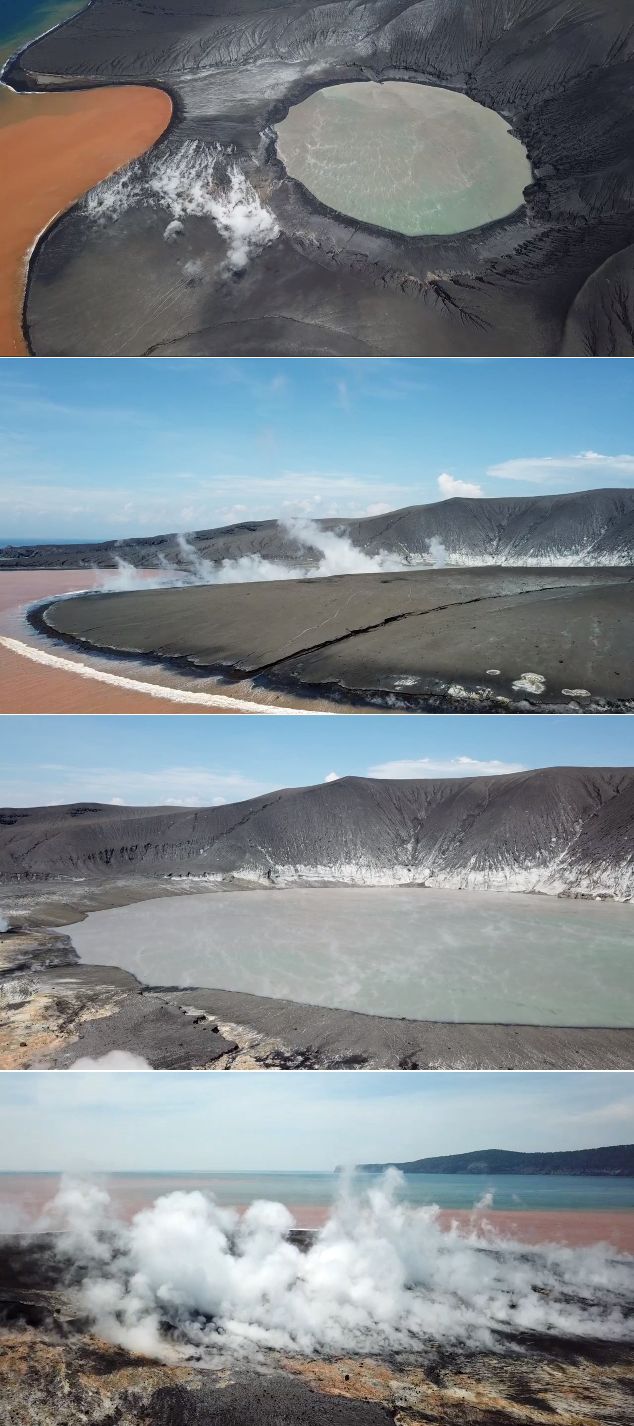
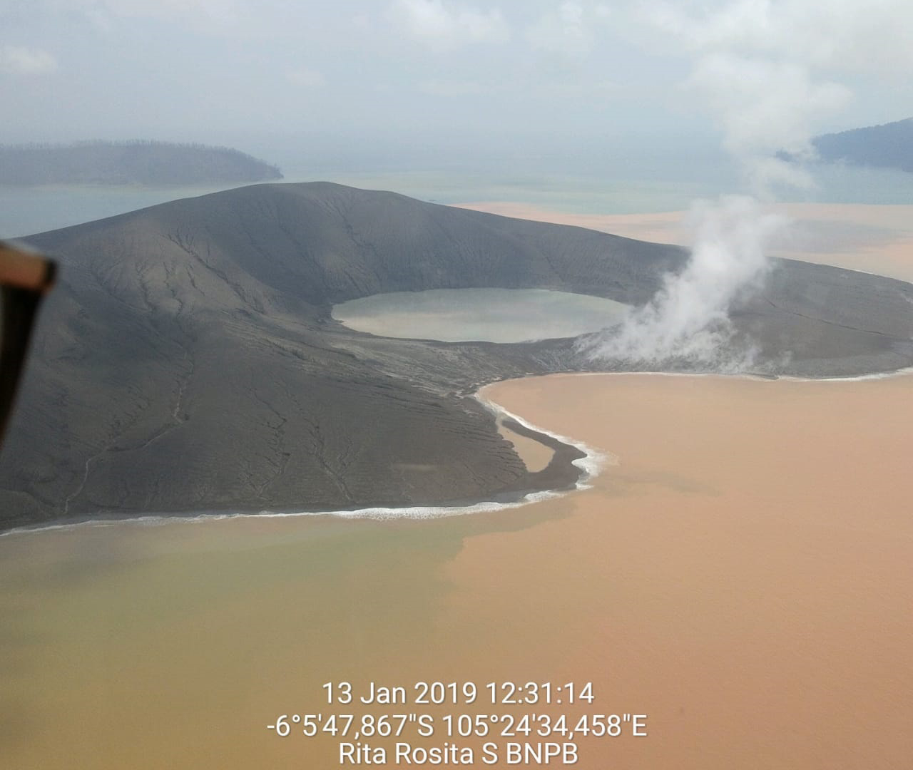
By 9 January a rim had formed, closing off the bay to the ocean and forming a circular crater lake. Photos by James Reynolds on 11 January show a new crater rim to the W of the vent, which was filled with water (figure 81). Steam and/or gas emissions were emanating from the surface in that area. The southern lava delta surface was covered with tephra, and part of the lava delta had been removed, leaving a smooth coastline. By the time these images were taken there was already extensive erosion of the fresh deposits around the island. Fresh material extended the coast in places and filled in bays to produce a more even shoreline.
References. Simkin, T., and Fiske, R.S., 1983, Krakatau 1883: the volcanic eruption and its effects: Smithsonian Institution Press, Washington DC, 464 p. ISBN 0-87474-841-0.
Sudradjat (Sumartadipura), A., 1982. The morphological development of Anak Krakatau Volcano, Sunda Straight. Geologi Indonesia, 9(1):1-11.
Geological Summary. The renowned Krakatau (frequently mis-named as Krakatoa) volcano lies in the Sunda Strait between Java and Sumatra. Collapse of an older edifice, perhaps in 416 or 535 CE, formed a 7-km-wide caldera. Remnants of that volcano are preserved in Verlaten and Lang Islands; subsequently the Rakata, Danan, and Perbuwatan cones were formed, coalescing to create the pre-1883 Krakatau Island. Caldera collapse during the catastrophic 1883 eruption destroyed Danan and Perbuwatan, and left only a remnant of Rakata. This eruption caused more than 36,000 fatalities, most as a result of tsunamis that swept the adjacent coastlines of Sumatra and Java. Pyroclastic surges traveled 40 km across the Sunda Strait and reached the Sumatra coast. After a quiescence of less than a half century, the post-collapse cone of Anak Krakatau (Child of Krakatau) was constructed within the 1883 caldera at a point between the former Danan and Perbuwatan cones. Anak Krakatau has been the site of frequent eruptions since 1927.
Information Contacts: Badan Nasional Penanggulangan Bencana (BNPB), National Disaster Management Agency, Graha BNPB - Jl. Scout Kav.38, East Jakarta 13120, Indonesia (URL: http://www.bnpb.go.id/); Sutopo Purwo Nugroho, BNPB (Twitter: @Sutopo_PN, URL: https://twitter.com/Sutopo_PN ); Geospatial Information Authority of Japan (GSI), 1 Kitasato, Tsukuba, Ibaraki 305-0811, Japan (URL: http://www.gsi.go.jp/ENGLISH/index.html); Badan Informasi Geospasial (BIG), Jl. Raya Jakarta - Bogor KM. 46 Cibinong 16911, Indonesia (URL: http://www.big.go.id/atlas-administrasi/); NASA Goddard Space Flight Center (NASA/GSFC), Global Sulfur Dioxide Monitoring Page, Atmospheric Chemistry and Dynamics Laboratory, 8800 Greenbelt Road, Goddard, Maryland, USA (URL: https://so2.gsfc.nasa.gov/); JAXA | Japan Aerospace Exploration Agency, 7-44-1 Jindaiji Higashi-machi, Chofu-shi, Tokyo 182-8522, Japan (URL: https://global.jaxa.jp/); MIROVA (Middle InfraRed Observation of Volcanic Activity), a collaborative project between the Universities of Turin and Florence (Italy) supported by the Centre for Volcanic Risk of the Italian Civil Protection Department (URL: http://www.mirovaweb.it/); Sentinel Hub Playground (URL: https://www.sentinel-hub.com/explore/sentinel-playground); Øystein Lund Andersen (Twitter: @OysteinLAnderse, https://twitter.com/OysteinLAnderse, URL: https://www.oysteinlundandersen.com/krakatau-volcano-witnessing-the-eruption-tsunami-22december2018/); James Reynolds, Earth Uncut TV (Twitter: @EarthUncutTV, URL: https://www.earthuncut.tv/, YouTube: https://www.youtube.com/channel/UCLKYsEXfI0PGXeKYL1KV7qA); Chris Vagasky, Vaisala Inc., Louisville, Colorado, USA (URL: https://www.vaisala.com/en?type=1, Twitter: @COweatherman, URL: https://twitter.com/COweatherman).