Report on Nyamulagira (DR Congo) — May 2019

Bulletin of the Global Volcanism Network, vol. 44, no. 5 (May 2019)
Managing Editor: Edward Venzke.
Edited by A. Elizabeth Crafford.
Nyamulagira (DR Congo) Lava lake reappears in central crater in April 2018; activity tapers off during April 2019
Please cite this report as:
Global Volcanism Program, 2019. Report on Nyamulagira (DR Congo) (Crafford, A.E., and Venzke, E., eds.). Bulletin of the Global Volcanism Network, 44:5. Smithsonian Institution. https://doi.org/10.5479/si.GVP.BGVN201905-223020
Nyamulagira
DR Congo
1.408°S, 29.2°E; summit elev. 3058 m
All times are local (unless otherwise noted)
The Virunga Volcanic Province (VVP) in the Democratic Republic of the Congo is part of the western branch of the East African Rift System. Nyamuragira (or Nyamulagira), a high-potassium basaltic shield volcano on the W edge of VVP, includes a lava field that covers over 1,100 km2 and contains more than 100 flank cones in addition to a large central crater (see figure 56, BGVN 42:06). A lava lake that had been active for many years emptied from the central crater in 1938. Numerous flank eruptions were observed after that time, the most recent during November 2011-March 2012 on the NE flank. This was followed by a period of degassing with unusually SO2-rich plumes from April 2012 through April 2014 (BGVN 42:06). The lava lake reappeared during July 2014-April 2016 and November 2016-May 2017, producing a strong thermal signature. After a year of quiet, a new lava lake appeared in April 2018, reported below (through May 2019) with information provided by the Observatoire Volcanologique de Goma (OVG), MONUSCO (the United Nations Organization working in the area), and satellite data and imagery from multiple sources.
Fresh lava reappeared inside the summit crater in mid-April 2018 from a lava lake and adjacent spatter cone. Satellite imagery and very limited ground-based observations suggested that intermittent pulses of activity from both sources produced significant lava flows within the summit crater through April 2019 when the strength of the thermal signal declined significantly. Images from May 2019 showed a smaller but persistent thermal anomaly within the crater.
Activity from October 2017-May 2019. Indications of thermal activity tapered off in May 2017 (BGVN 42:11). On 20 October 2017 OVG released a communication stating that a brief episode of unspecified activity occurred on 17 and 18 October, but the volcano returned to lower activity levels on 20 October. There was no evidence of thermal activity during the month. The volcano remained quiet with no reports of thermal activity until April 2018 (figure 66).
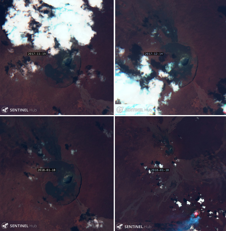 |
Figure 66. Sentinel-2 satellite images (bands 12, 4, 2) indicated no thermal activity at Nyamuragira on 19 November (top left), 14 December 2017 (top right) and 18 January 2018 (bottom). However, Nyiragongo (about 13 km SE) had an active lava lake with a gas plume drifting SW on 18 January 2018 (bottom right). Courtesy of Sentinel Hub Playground. |
OVG reported the new lava emissions beginning on 14 April 2018 as appearing from both the lava lake and a small adjacent spatter cone (figure 67). The first satellite image showing thermal activity at the summit appeared on 18 April 2018 (figure 68) and coincided with the abrupt beginning of strong MIROVA thermal signals (figure 69). MODVOLC thermal alerts also first appeared on 18 April 2018. An image of the active crater taken on 9 May 2018 showed the lake filled with fresh lava and two adjacent incandescent spatter cones (figure 70).
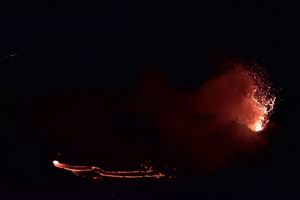 |
Figure 67. Fresh lava reappeared at Nyamuragira's crater during April 2018 from the lava lake (left) and the adjacent small spatter cone (right). Courtesy of OVG (Republique Democratique du Congo, Ministere de la Recherche Scientifique, Observatoire Volcanologique de Goma, Direction Generale Goma, Rapport Avril 2018). |
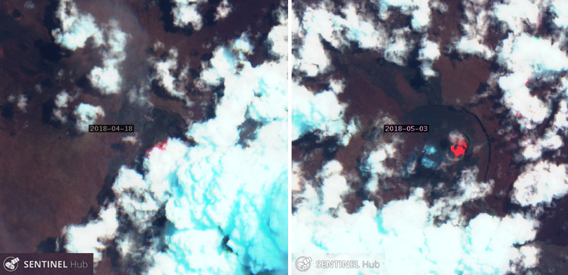 |
Figure 68. The first satellite image (bands 12, 4, 2) indicating renewed thermal activity at the Nyamuragira crater appeared on 18 April 2018; the signal remained strong a few weeks later on 3 May 2018. Courtesy of Sentinel Hub Playground. |
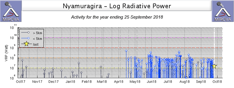 |
Figure 69. A strong thermal signal appeared in the MIROVA graph of Log Radiative Power on 18 April 2018 for Nyamuragira, indicating a return of the lava lake at the summit crater. Courtesy of MIROVA. |
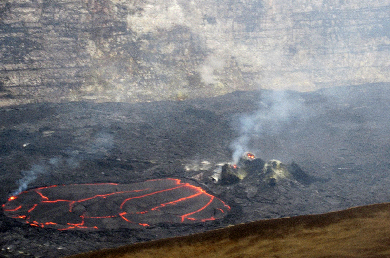 |
Figure 70. Fresh lava filled the lake inside the crater at Nyamuragira on 9 May 2018. Two spatter cones were incandescent with gas emissions. Courtesy of OVG (Republique Democratique du Congo, Ministere de la Recherche Scientifique, Observatoire Volcanologique de Goma, Direction Generale Goma, Rapport Mai 2018). |
Satellite images confirmed that ongoing activity from the lava lake remained strong during June -September 2018 (figure 71). A mission to Nyamuragira was carried out by helicopter provided by MONUSCO on 20 July 2018; lava lake activity was observed along with gas emissions from the small spatter cone (figure 72). OVG reported increased volcanic seismicity during 1-3 and 10-17 September 2018, and also during October, located in the crater area, mostly at depths of 0-5 km.
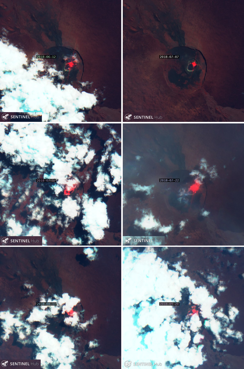 |
Figure 71. Sentinel-2 satellite images (bands 12, 4, 2) confirmed that ongoing activity from the lava lake at Nyamuragira remained strong during June-September 2018, likely covering the crater floor with a significant amount of fresh lava. Image are from 12 June (top left), 7 July (top right), 17 July (middle left), 22 July (middle right), 11 August (bottom left), and 20 September (bottom right). Courtesy of Sentinel Hub Playground. |
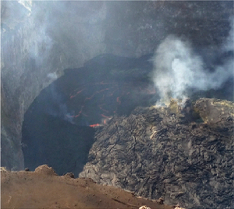 |
Figure 72. The crater at Nyamuragira on 20 July 2018 had an active lava lake and adjacent incandescent spatter cone with gas emissions. Courtesy of OVG (Republique Democratique du Congo, Ministere de la Recherche Scientifique, Observatoire Volcanologique de Goma, Direction Generale Goma, Rapport Juillet 2018). |
Personnel from OVG and MONUSCO (United Nations Organization Stabilization Mission in DR Congo) made site visits on 11 October and 2 November 2018 and concluded that the level of the active lava lake had increased during that time (figure 73). On 2 November OVG measured the height from the base of the active cone to the W rim of the crater as 58 m (figure 74).
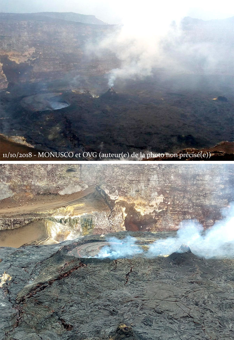 |
Figure 73. OVG scientists reported a rise in the lake level between site visits to the Nyamuragira crater on 11 October (top) and 2 November 2018 (bottom). Top image courtesy of MONUSCO and Culture Vulcan, bottom image courtesy of OVG (Republique Democratique du Congo, Ministere de la Recherche Scientifique, Observatoire Volcanologique de Goma, Direction Generale Goma, Rapport Octobre 2018). |
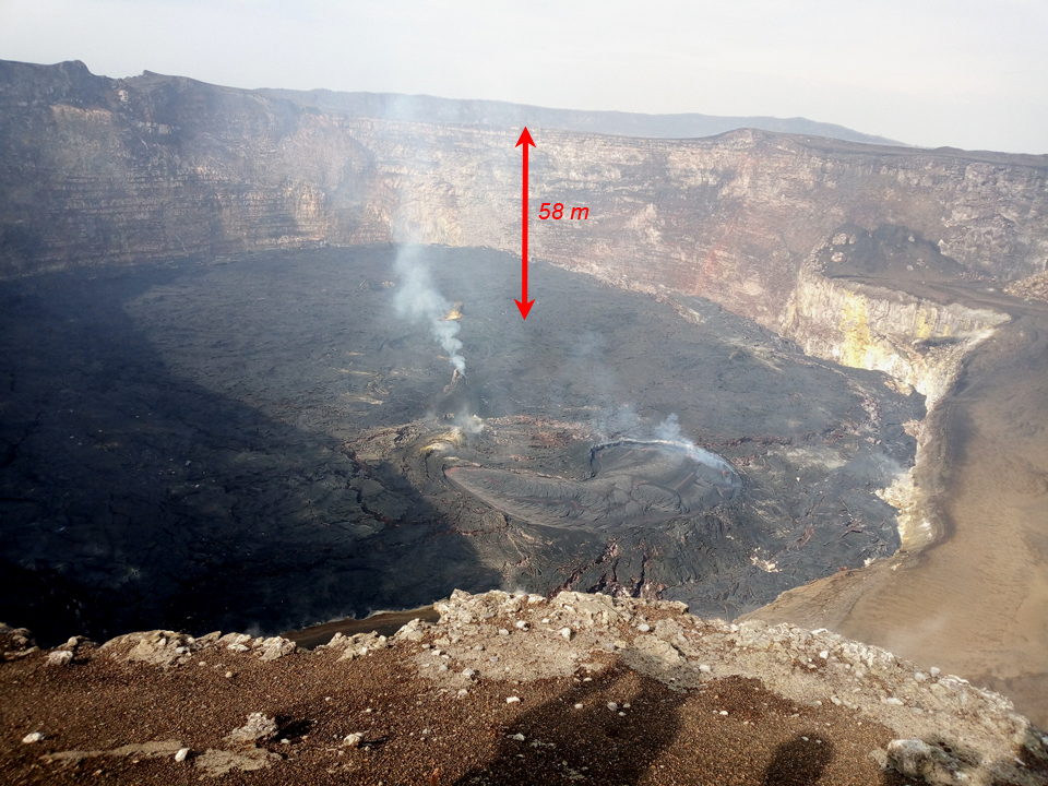 |
Figure 74. On 2 November 2018 scientists from OVG measured the height from the base of the active cone to the W rim of the crater as 58 m. Courtesy of OVG (Republique Democratique du Congo, Ministere de la Recherche Scientifique, Observatoire Volcanologique de Goma, Direction Generale Goma, Rapport Octobre 2018). |
Seismicity remained high during November 2018 but decreased significantly during December. Instrument and access issues in January 2019 prevented accurate assessment of seismicity for the month. The lava lake remained active with periodic surges of thermal activity during November 2018-March 2019 (figure 75). Multiple images show incandescence in multiple places within the crater, suggesting significant fresh overflowing lava.
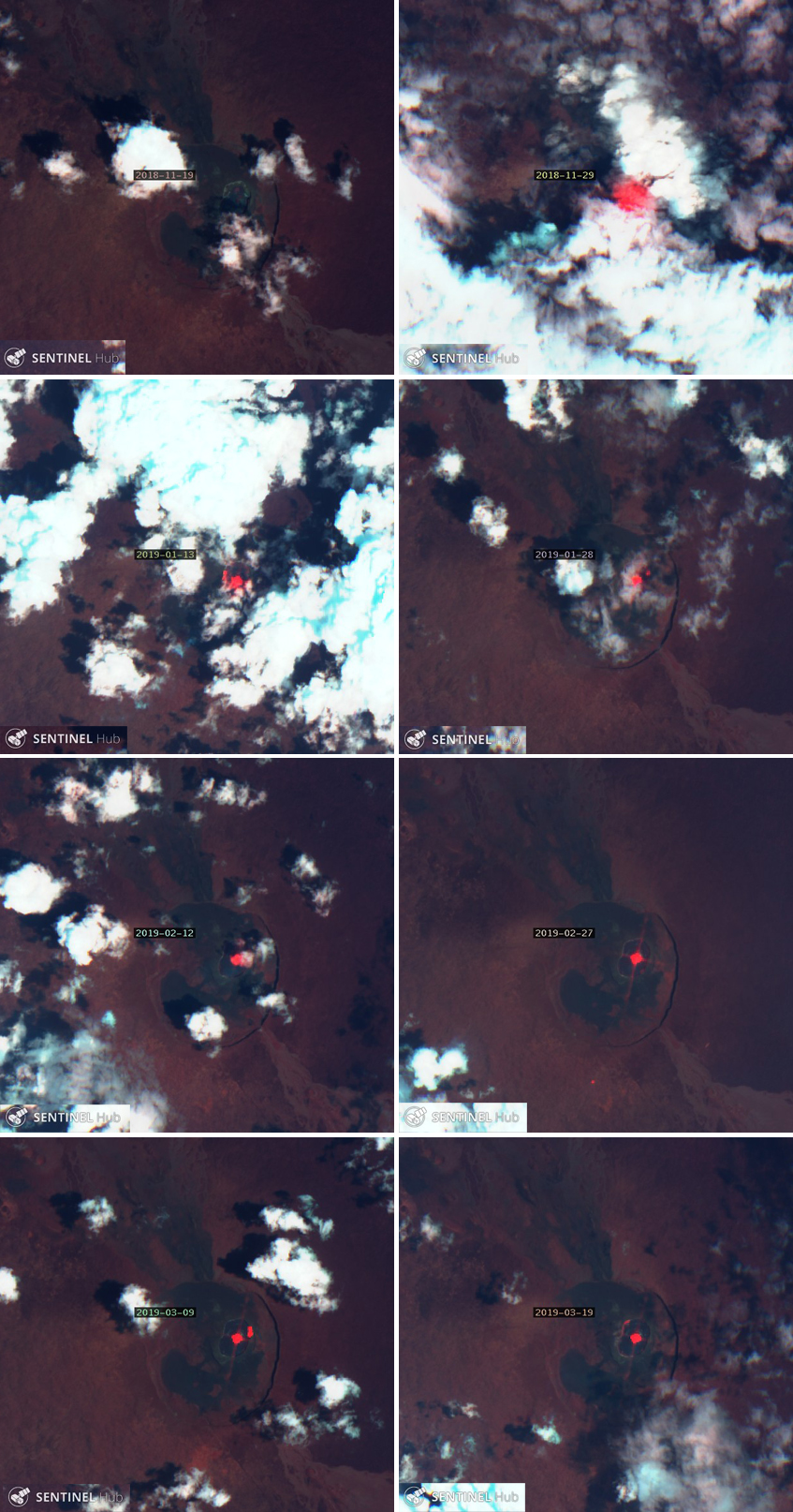 |
Figure 75. The active lava lake at Nyamuragira produced strong thermal signals from November 2018 through March 2019 that were recorded in Sentinel-2 satellite images (bands 12, 4, 2). Several images suggest fresh lava cooling around the rim of the crater in addition to the active lake. A relatively cloud-free day on 19 November 2018 (top left) revealed no clear thermal signal, but a strong signal was recorded on 29 November (top right) despite significant cloud cover. Images from 13 and 28 January 2019 (second row) both showed evidence of incandescent lava in multiple places within the crater. The thermal signal was smaller and focused on the center of the crater on 12 and 27 February 2019 (third row). Images taken on 9 and 19 March 2019 clearly showed incandescent material at the center of the crater and around the rim (bottom row). Courtesy of Sentinel Hub Playground. |
On 12 April 2019 a Ukrainian Aviation Unit supported by MONUSCO provided support for scientists visiting the crater for observations and seismic analysis. Satellite data confirmed ongoing thermal activity into May, although the strength of the signal appeared to decrease (figure 76). MODVOLC thermal alerts ceased after 8 April, and the MIROVA thermal data also confirmed a decrease in the strength of the thermal signal during April 2019 (figure 77).
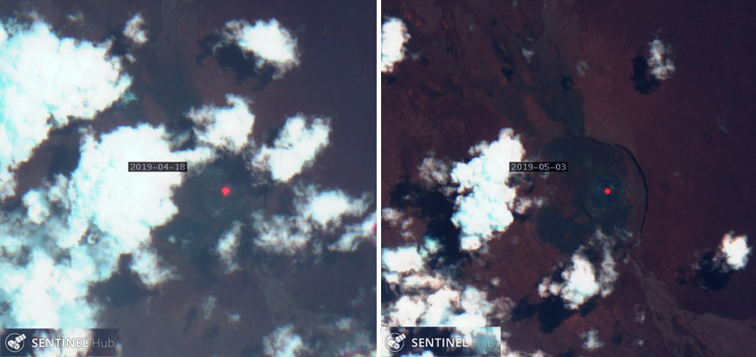 |
Figure 76. Sentinel-2 satellite data (bands 12, 4, 2) confirmed ongoing thermal activity at Nyamuragira into May 2019. The thermal anomalies on 18 April (left) and 3 May (right) 2019 were smaller than those recorded during previous months. Courtesy of Sentinel Hub Playground. |
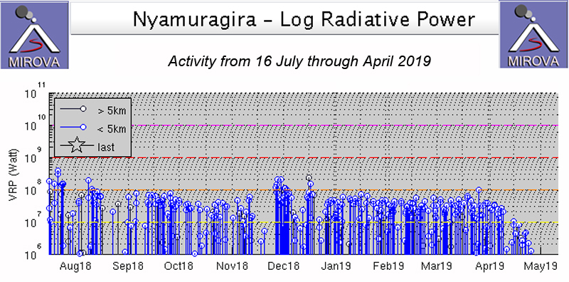 |
Figure 77. The MIROVA graph of thermal activity (log radiative power) at Nyamuragira from 16 July 2018 through April 2019 showed near-constant levels of high activity through April 2019 when it declined. This corresponded well with satellite and ground-based observations. Courtesy of MIROVA. |
Geological Summary. Africa's most active volcano, Nyamulagira (also known as Nyamuragira), is a massive high-potassium basaltic shield about 25 km N of Lake Kivu and 13 km NNW of the steep-sided Nyiragongo volcano. The summit is truncated by a small 2 x 2.3 km caldera that has walls up to about 100 m high. Documented eruptions have occurred within the summit caldera, as well as from the numerous flank fissures and cinder cones. A lava lake in the summit crater, active since at least 1921, drained in 1938, at the time of a major flank eruption. Recent lava flows extend down the flanks more than 30 km from the summit as far as Lake Kivu; extensive lava flows from this volcano have covered 1,500 km2 of the western branch of the East African Rift.
Information Contacts: Observatoire Volcanologique de Goma (OVG), Departement de Geophysique, Centre de Recherche en Sciences Naturelles, Lwiro, D.S. Bukavu, DR Congo; Katcho Karume, Director; Sentinel Hub Playground (URL: https://www.sentinel-hub.com/explore/sentinel-playground); MIROVA (Middle InfraRed Observation of Volcanic Activity), a collaborative project between the Universities of Turin and Florence (Italy) supported by the Centre for Volcanic Risk of the Italian Civil Protection Department (URL: http://www.mirovaweb.it/); Hawai'i Institute of Geophysics and Planetology (HIGP) - MODVOLC Thermal Alerts System, School of Ocean and Earth Science and Technology (SOEST), Univ. of Hawai'i, 2525 Correa Road, Honolulu, HI 96822, USA (URL: http://modis.higp.hawaii.edu/); MONUSCO, United Nations Organization Stabilization Mission in the DR Congo (URL: https://monusco.unmissions.org/en/, Twitter: @MONUSCO); Cultur Volcan, Journal d'un volcanophile (URL: https://laculturevolcan.blogspot.com), Twitter: @CultureVolcan).