Report on Krakatau (Indonesia) — August 2019

Bulletin of the Global Volcanism Network, vol. 44, no. 8 (August 2019)
Managing Editor: Edward Venzke.
Edited by A. Elizabeth Crafford.
Krakatau (Indonesia) Repeated Surtseyan explosions with ash and steam during February-July 2019
Please cite this report as:
Global Volcanism Program, 2019. Report on Krakatau (Indonesia) (Crafford, A.E., and Venzke, E., eds.). Bulletin of the Global Volcanism Network, 44:8. Smithsonian Institution. https://doi.org/10.5479/si.GVP.BGVN201908-262000
Krakatau
Indonesia
6.1009°S, 105.4233°E; summit elev. 285 m
All times are local (unless otherwise noted)
Krakatau volcano in the Sunda Strait between Java and Sumatra, Indonesia experienced a major caldera collapse around 535 CE; it formed a 7-km-wide caldera ringed by three islands. Remnants of this volcano joined to create the pre-1883 Krakatau Island which collapsed during the major 1883 eruption. Anak Krakatau (Child of Krakatau), constructed beginning in late 1927 within the 1883 caldera (BGVN 44:03, figure 56), was the site of over 40 smaller episodes until 22 December 2018 when a large explosion and tsunami destroyed most of the 338-m-high edifice (BGVN 44:03). Subsequent activity from February-July 2019 is covered in this report with information provided by the Indonesian Center for Volcanology and Geological Hazard Mitigation, referred to as Pusat Vulkanologi dan Mitigasi Bencana Geologi (PVMBG). Aviation reports are provided by the Darwin Volcanic Ash Advisory Center (VAAC), and photographs from several social media sources.
The cyclical nature of the growth and destruction of Krakatau was made apparent again in the explosive events of 22 December 2018-6 January 2019, when much of the island of Anak Krakatau was destroyed in a series of events that included a deadly tsunami from a flank collapse, a Vulcanian explosion, and several days of Surtseyan phreatomagmatic activity (figure 83) (Gouhier and Paris, 2019). Due to the location of the volcano in the middle of Sunda Strait, surrounded by coastal communities, damage from the tsunami was once again significant; over 400 fatalities and 30,000 injuries were reported along with damage to thousands of homes, businesses, and boats (figure 84) (BGVN 44:03). After a small explosion on 8 January 2019, the volcano remained quiet until 14 February when a new seismic event was recorded. Intermittent explosions increased in frequency and continued through July 2019; images of Surtseyan explosions with ejecta and steam rising a few hundred meters were occasionally captured by authorities patrolling the Krakatau Islands Nature Preserve and Marine Nature Reserve (KPHK), and by a newly installed webcam.
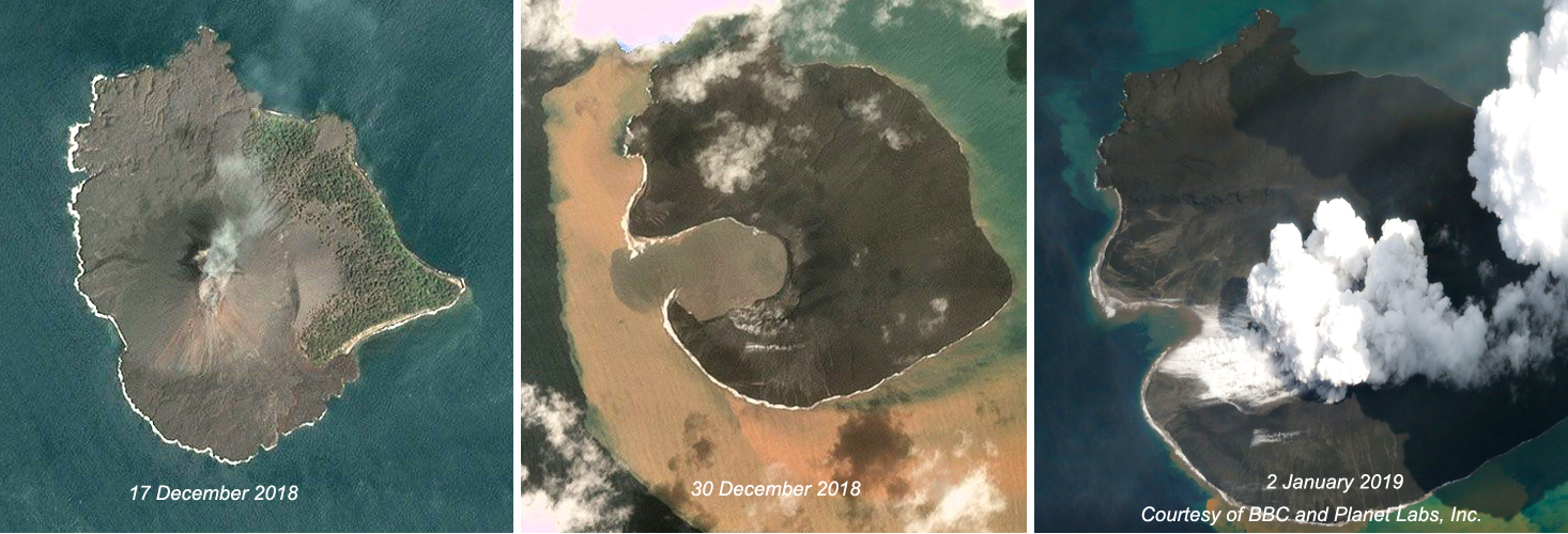 |
Figure 83. The dramatic morphologic changes of Anak Krakatau before and after the explosive events of 22 December 2019-6 January 2019 were apparent in these Planet Labs, Inc. images published by the BBC. Left: Planet Lab's Dove satellite captured this clear image of the 338-m-high cone with a summit crater on 17 December 2018. Center: The skies cleared enough on 30 December to reveal the new crater in place of the former cone after the explosions and tsunami of 22-23 December, and multiple subsequent explosions. Right: Surtseyan explosions continued daily through 6 January; Planet Labs captured this event on 2 January 2019. Courtesy of BBC and Planet Labs, Inc. |
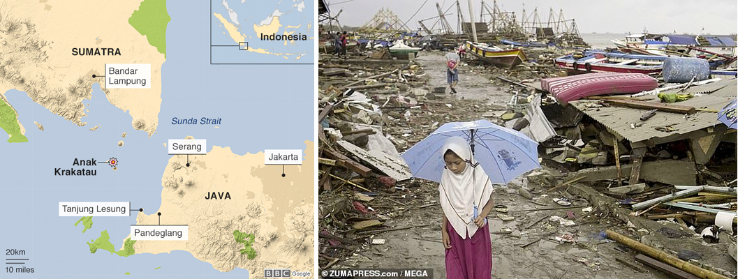 |
Figure 84. The location of Anak Krakatau in the middle of Sunda Strait surrounded by populated coastal communities (left) places great risk on those communities from explosive events and tsunamis at the volcano, such as what occurred during the 22 December 2018-6 January 2019 destruction of Anak Krakatau. The village of Tanjung in South Lampung (right) was especially hard hit. Map courtesy of BBC News, and photo courtesy of Daily Mail. |
Three explosions were reported on 14, 18, and 23 February. No ash plume was observed on 14 February. The event on 18 February produced a dense gray ash plume that rose 720 m and drifted SSW. On 23 February the plume was white and rose 500 m, drifting ENE. During most days, no emissions were observed; occasional plumes of steam rose 50-100 m above the crater. Authorities visited the island on 15 February and observed the new crater lake and ash-covered flank of the remnant cone (figure 85 and 86).
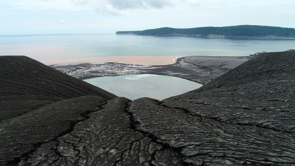 |
Figure 85. The denuded slope and new crater at Anak Krakatau on 15 February 2019. Bright orange discoloration of the water on the W side of the volcano is from recent iron-rich discharge. The new summit was measured at 155 m high. Verlaten Island is in the background. Courtesy of Sutopo Purwo Nugroho, BNPB. |
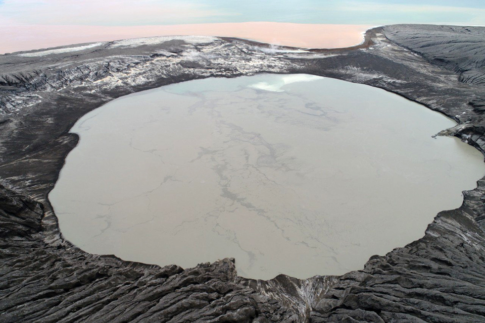 |
Figure 86. The new crater at Anak Krakatau on 15 February 2019. Fumarolic activity is visible in the narrow strip between the crater and the bay; bright orange discoloration of the water on the W side of the volcano is from recent iron-rich discharge. Courtesy of Sutopo Purwo Nugroho, BNPB. |
Activity increased during March 2019 with 14 seismic events recorded. Four events on 14 March were reported, with durations ranging from 30 seconds to 4 minutes; neither ash nor steam plumes were reported from these events. Events on 16, 17, and 18 March produced N-drifting white steam plumes that were reported at altitudes of 1.2 km, 650 m, and 350 m, respectively (figure 87). Multiple additional explosions were reported on 24, 30, and 31 March; dense white plumes drifted NE on 30 and 31 March. Nearby rangers for the KPHK who witnessed the explosions on 30 March reported material rising 500-1,000 m above the crater (figure 88). The duration of the seismic events associated with the explosions ranged from 40 seconds to 5 minutes during the second half of March. PVMBG lowered the Alert Level from III to II on 25 March, noting that while explosions continued, the intensity and frequency had decreased; none of the explosions were heard at the Pasauran-Banten (SE) or Kalianda-Lampung (NE) stations that were each about 50 km away.
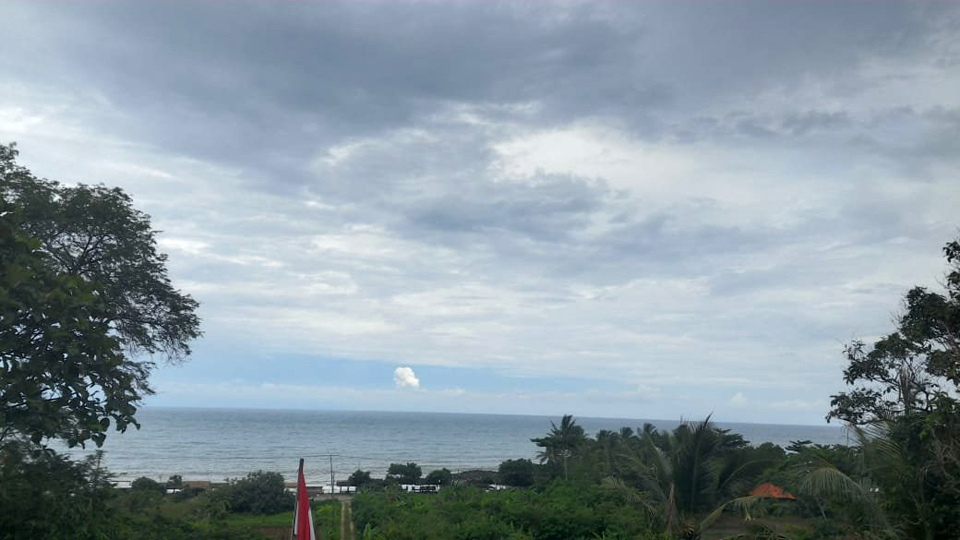 |
Figure 87. An eruption at Krakatau on 18 March 2019 produced a steam plume that rose several hundred meters, barely visible from a community across the strait. Courtesy of Oystein Anderson and PVMBG. |
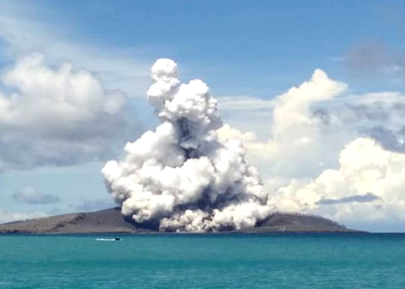 |
Figure 88. White steam and dark ejecta were observed at Anak Krakatau during an explosion on 30 March 2019 by the local patrol team from BKSDA Bengkulu-Ministry of LHK, which manages the Krakatau Islands Nature Preserve and Marine Nature Reserve. Courtesy of Krakatau Islands KPHK. |
Although the number of reported seismic events increased significantly during April and May 2019, with 22 VONA's issued during April and 41 during May, only a single event had witnessed evidence of ejecta on 3 April (figure 89). The KPHK patrol that monitors conditions on the islands observed the first plant life returning on Sertung Island (5 km W of Anak Krakatau) on 5 April 2019, emerging through the several centimeters of fresh ash from the explosions and tsunami in late December and early January (figure 90). A 200-m-high steam plume was observed on 14 April, and plumes drifted NE and E on 27 and 29 April.
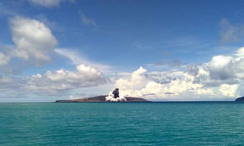 |
Figure 89. Rangers for KPHK photographed a Surtseyan explosion with tephra and steam at Anak Krakatau on 3 April 2019. Courtesy of Krakatau Islands KPHK. |
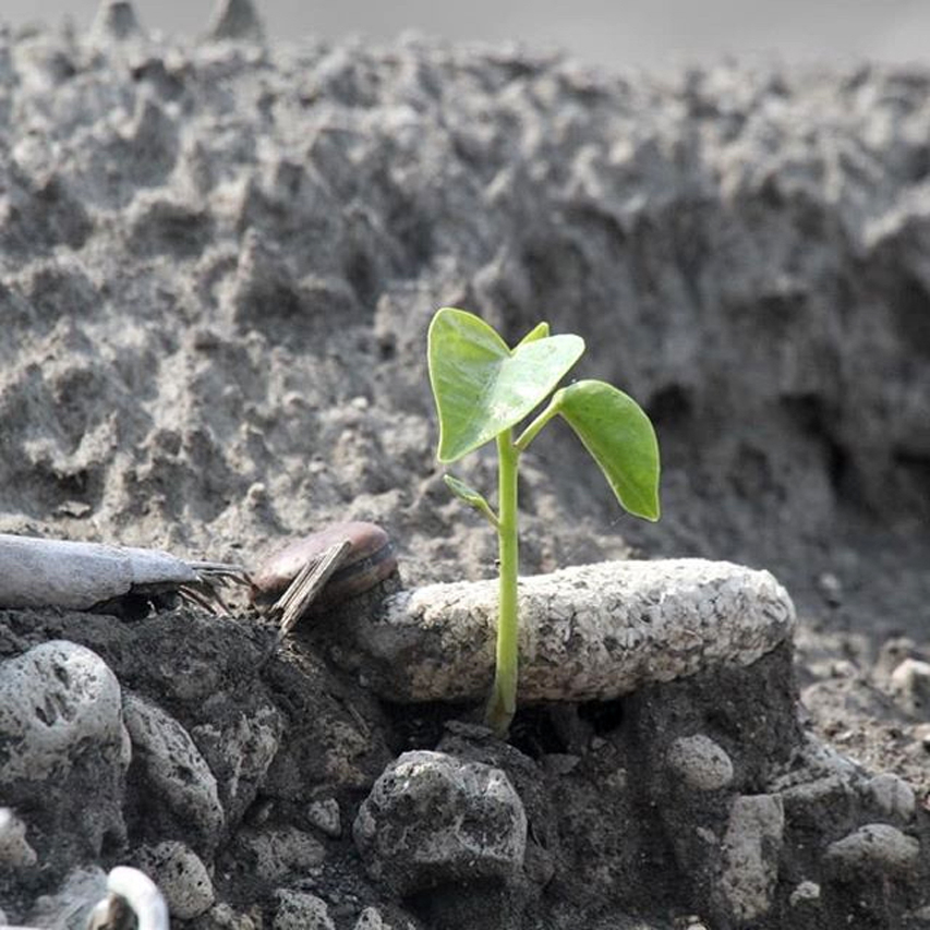 |
Figure 90. A new plant on nearby Sertung Island emerges on 5 April 2019 through several centimeters of fresh ash from the Anak Krakatau explosions of December 2018 and January 2019. Courtesy of Krakatau Islands KPHK. |
Members of an expedition to the island on 4 May 2019 photographed the still-steaming lake inside the new crater and the eroding ash-covered slopes (figure 91). Only the explosions on 10 and 17 May produced visible steam plumes that month, to 300-350 m high. By 15 May 2019 a new station had been installed at Anak Krakatau by PVMBG (figure 92). Four separate seismic events were recorded that day. Fog covered the island on a daily basis, and very few visible steam plumes were reported throughout April and May. The durations of the explosion events ranged from 30 seconds to 13 minutes (on 10 May); most of the events lasted for 1-2 minutes.
 |
Figure 91. Members of an expedition photographed the water-filled crater and ash-laden slopes of Anak Krakatau on 4 May 2019. Top image is looking S with Rakata island in the background, bottom image is looking W from the flank of the cone remnant. Photo by Galih Jati, courtesy of Volcano Discovery. |
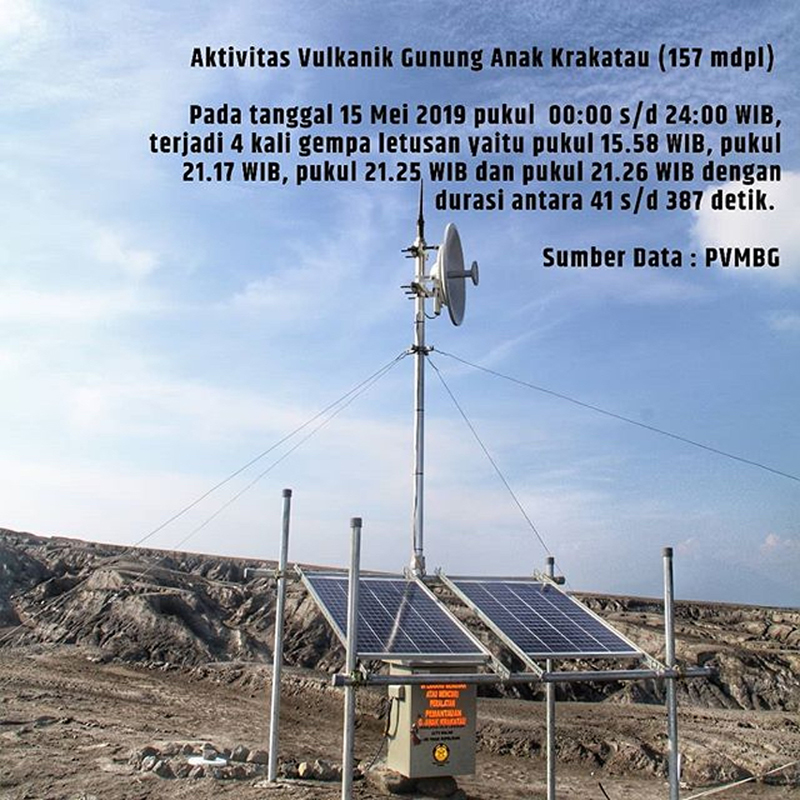 |
Figure 92. By 15 May 2019 a new seismic station had been installed at Anak Krakatau by PVMBG. Four separate seismic events were recorded on 15 May 2019. Courtesy of Krakatau Islands KPHK. |
Nine explosive events were reported during June 2019, but none produced visible steam or ash plumes until 25 June when a PVMBG webcam placed on Anak Krakatau captured a video of a Surtseyan event that lasted for about one minute. Dark gray ejecta shot tens of meters into the air over the lake, accompanied by billowing steam plumes which soon engulfed the webcam (figure 93). The other explosive events during March-July were likely similar, but frequent fog and the short-lived nature of the events made visual evidence scarce from webcams located 50 km away. During July there were 21 VONAs issued reporting similar seismic events that lasted from 30 seconds to 5 minutes; no plumes or sounds were seen or heard.
 |
Figure 93. Dark gray ejecta and billowing steam plumes were captured by a newly installed PVMBG webcam during an explosion at Anak Krakatau on 25 June 2019. The water-laden ash rose tens of meters and scattered ejecta around the island. See Information Contacts for a link to the video. Courtesy of Devy Kamil Syahbana and PVMBG. |
Satellite imagery provided solid evidence that activity at Anak Krakatau during February-July 2019 included underwater venting. Dark orange submarine plumes were visible drifting away from the SW flank of the volcano near the new crater multiple times each month (figure 94). The patterns of the plumes varied in size and intensity, suggesting repeated injections of material into the water. The thermal activity showed a marked decline from the period prior to the large explosions and tsunami on 22-23 December 2018. Very little thermal activity was reported during January-March 2019, it increased moderately during April-July 2019 (figure 95).
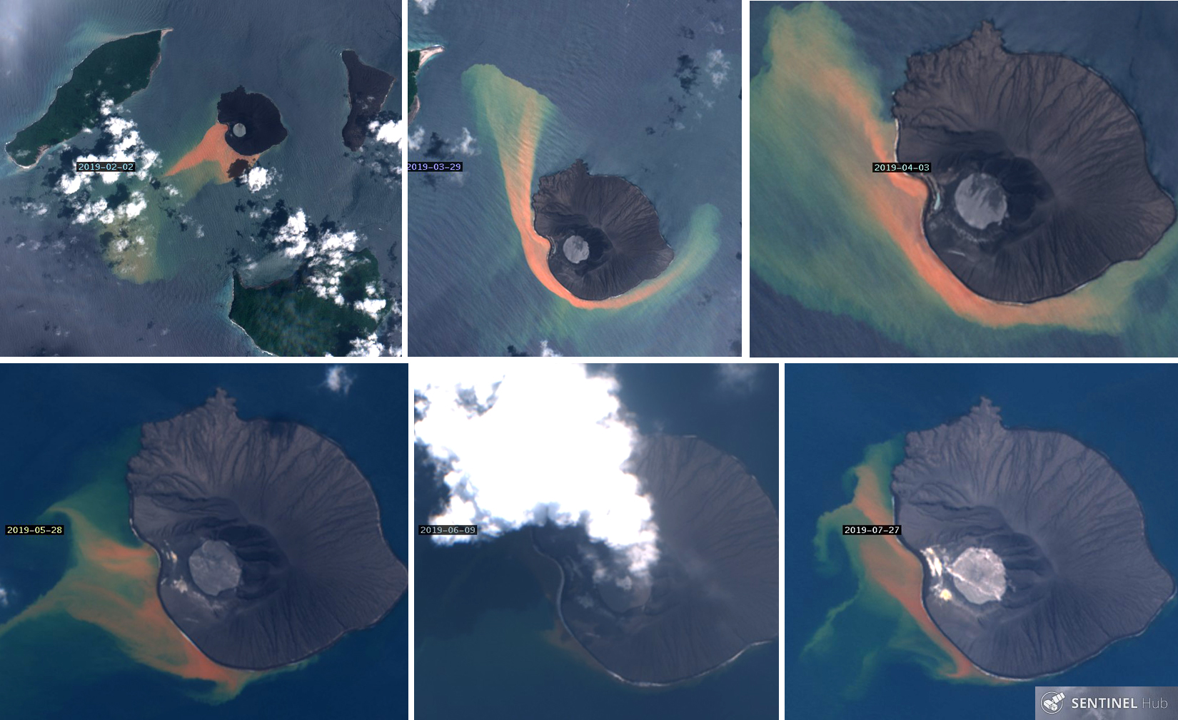 |
Figure 94. Dark orange plumes were visible in the seawater around Anak Krakatau during February-July 2019, strongly suggesting submarine discharges from the volcano. Top left: On 2 February 2019 the plume was discharging to the SW and visible in the water for nearly 10 km. Top center and right: on 29 March and 3 April the brightest areas of discharge were off the immediate SW flank; the plumes were drifting both NW and SE around the island. By 28 May (bottom left) the discharge was concentrated close to the SW flank with multiple underwater plumes suggesting several emission points. The only satellite image evidence suggesting a subaerial eruption appeared on 9 June (bottom center) when a dense steam plume rising and possible ejecta in the crater were visible. By 27 July (bottom right), discharge was still visible from the underwater vents on the SW flank, and the gradual filling in of the embayment on the W flank, when compared with the 2 February image, was clear. The island is about 2 km in diameter. Sentinel-2 satellite images with natural color rendering (bands 4,3,2) courtesy of Sentinel Hub Playground. |
 |
Figure 95. Thermal activity dropped abruptly at Anak Krakatau after the major flank collapse, explosions, and tsunami on 22-23 December 2018; it remained quiet through March and increased modestly during April-July 2019. Courtesy of MIROVA. |
References: Gouhier, M, and Paris, R, 2019, SO2 and tephra emissions during the December 22, 2018 Anak Krakatau flank-collapse eruption, Volcanica 2(2): 91-103. doi: 10.30909/vol.02.02.91103.
Geological Summary. The renowned Krakatau (frequently mis-named as Krakatoa) volcano lies in the Sunda Strait between Java and Sumatra. Collapse of an older edifice, perhaps in 416 or 535 CE, formed a 7-km-wide caldera. Remnants of that volcano are preserved in Verlaten and Lang Islands; subsequently the Rakata, Danan, and Perbuwatan cones were formed, coalescing to create the pre-1883 Krakatau Island. Caldera collapse during the catastrophic 1883 eruption destroyed Danan and Perbuwatan, and left only a remnant of Rakata. This eruption caused more than 36,000 fatalities, most as a result of tsunamis that swept the adjacent coastlines of Sumatra and Java. Pyroclastic surges traveled 40 km across the Sunda Strait and reached the Sumatra coast. After a quiescence of less than a half century, the post-collapse cone of Anak Krakatau (Child of Krakatau) was constructed within the 1883 caldera at a point between the former Danan and Perbuwatan cones. Anak Krakatau has been the site of frequent eruptions since 1927.
Information Contacts: Pusat Vulkanologi dan Mitigasi Bencana Geologi (PVMBG, also known as Indonesian Center for Volcanology and Geological Hazard Mitigation, CVGHM), Jalan Diponegoro 57, Bandung 40122, Indonesia (URL: http://www.vsi.esdm.go.id/); Krakatau Islands KPHK, Conservation Area Region III Lampung, BKSDA Bengkulu-Ministry of LHK, (URL: https://www.instagram.com/krakatau_ca_cal); Sentinel Hub Playground (URL: https://www.sentinel-hub.com/explore/sentinel-playground); MIROVA (Middle InfraRed Observation of Volcanic Activity), a collaborative project between the Universities of Turin and Florence (Italy) supported by the Centre for Volcanic Risk of the Italian Civil Protection Department (URL: http://www.mirovaweb.it/); BBC News, (URL: https://www.bbc.com, article at https://www.bbc.com/news/science-environment-46743362); Planet Labs Inc. (URL: http://www.planet.com/); Sutopo Purwo Nugroho, BNPB (Twitter: @Sutopo_PN, URL: https://twitter.com/Sutopo_PN, image at https://twitter.com/Sutopo_PN/status/1101007655290589185/photo/1); Øystein Lund Andersen? (Twitter: @OysteinLAnderse, https://twitter.com/OysteinLAnderse, URL: http://www.oysteinlundandersen.com, image at https://twitter.com/OysteinLAnderse/status/1107479025126039552/photo/1); Tom Pfeiffer, Volcano Discovery (URL: http://www.volcanodiscovery.com/), images at https://www.volcanodiscovery.com/krakatau/news/80657/Krakatau-volcano-Indonesia-activity-update-and-field-report-increasing-unrest.html; Devy Kamil Syahbana, Volcanologist, Bandung, Indonesia, (URL: https://twitter.com/_elangtimur, video at https://twitter.com/_elangtimur/status/1143372011177033728); The Daily Mail (URL: https://www.dailymail.co.uk, article at https://www.dailymail.co.uk/sciencetech/article-6910895/FORTY-volcanoes-world-potential-Anak-Krakatoa-eruptions.html) published 11 April 2019.