Report on Erebus (Antarctica) — January 2020

Bulletin of the Global Volcanism Network, vol. 45, no. 1 (January 2020)
Managing Editor: Edward Venzke.
Research and preparation by Paul Berger.
Erebus (Antarctica) Lava lakes persist through 2019
Please cite this report as:
Global Volcanism Program, 2020. Report on Erebus (Antarctica) (Venzke, E., ed.). Bulletin of the Global Volcanism Network, 45:1. Smithsonian Institution. https://doi.org/10.5479/si.GVP.BGVN202001-390020
Erebus
Antarctica
77.53°S, 167.17°E; summit elev. 3794 m
All times are local (unless otherwise noted)
Erebus, the world's southernmost historically active volcano, overlooks the McMurdo research station on Antarctica's Ross Island, 35 km SSW. Because of the remoteness of the volcano, activity is primarily monitored using satellites (figure 27), including MODIS infrared detectors aboard the Aqua and Terra satellites and analyzed using the MODVOLC algorithm.
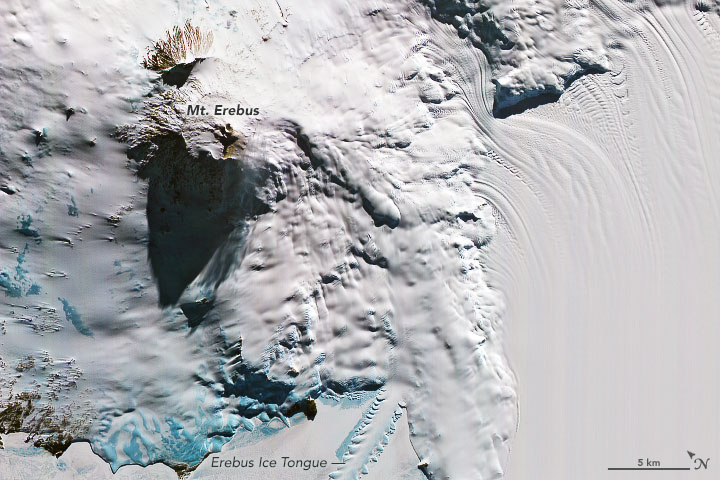 |
Figure 27. Satellite image of Erebus (on left) acquired on 19 October 2019 by the Advanced Spaceborne Thermal Emission and Reflection Radiometer (ASTER) on NASA's Terra satellite. The false-color combines visible and near-infrared wavelengths of light (ASTER bands 3, 2, 1). The area was just days away from constant 24-hour sunlight when this image was acquired, with the Sun angle low enough to cast a long shadow towards the west. The blue patches are areas clear of surface snow, exposing glacial ice. Nearby areas that appear smooth are the snow- and ice-topped waters of McMurdo Sound. Courtesy of NASA Earth Observatory: image by Joshua Stevens, using data from NASA/METI/AIST/Japan Space Systems and U.S./Japan ASTER Science Team; description by Kathryn Hansen. |
Available since 2000, MODIS-MODVOLC data have shown a strong and nearly continuous thermal signal through 2019. A compilation of thermal alert pixels during 2017-2019 (table 5, continuing the table in BGVN 44:01) shows a wide range of detected activity in 2019, with a high of 162 in April. Infrared satellite imagery from Sentinel-2 identified one or two lava lakes during January-March and September-December 2019; a few of the images showed gas emissions, possibly from melted snow (figure 28).
Table 5. Number of monthly MODVOLC thermal alert pixels recorded at Erebus from 1 January 2017 to 31 December. Table compiled using data provided by the Hawai'i Institute of Geophysics and Planetology (HIGP) - MODVOLC Thermal Alerts System.
| Year | Jan | Feb | Mar | Apr | May | Jun | Jul | Aug | Sep | Oct | Nov | Dec | SUM |
| 2017 | 0 | 21 | 9 | 0 | 0 | 1 | 11 | 61 | 76 | 52 | 0 | 3 | 234 |
| 2018 | 0 | 21 | 58 | 182 | 55 | 17 | 137 | 172 | 103 | 29 | 0 | 0 | 774 |
| 2019 | 2 | 21 | 162 | 151 | 55 | 56 | 75 | 53 | 29 | 19 | 1 | 0 | 624 |
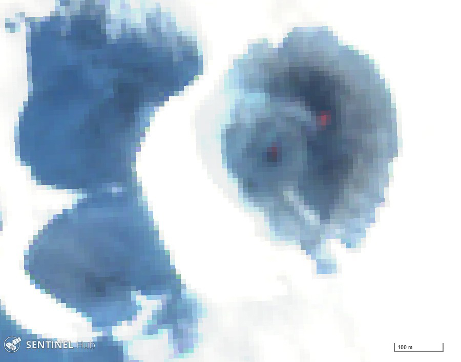 |
Figures 28. Sentinel-2 satellite image of Erebus in color infrared (bands 8, 4, 3) on 20 October 2019 showing two lava lakes in the summit crater. Courtesy of Sentinel Hub Playground. |
Geological Summary. Mount Erebus, the world's southernmost historically active volcano, overlooks the McMurdo research station on Ross Island. It is the largest of three major volcanoes forming the crudely triangular Ross Island. The summit of the dominantly phonolitic volcano has been modified by one or two generations of caldera formation. A summit plateau at about 3,200 m elevation marks the rim of the youngest caldera, which formed during the late-Pleistocene and within which the modern cone was constructed. An elliptical 500 x 600 m wide, 110-m-deep crater truncates the summit and contains an active lava lake within a 250-m-wide, 100-m-deep inner crater; other lava lakes are sometimes present. The glacier-covered volcano was erupting when first sighted by Captain James Ross in 1841. Continuous lava-lake activity with minor explosions, punctuated by occasional larger Strombolian explosions that eject bombs onto the crater rim, has been documented since 1972, but has probably been occurring for much of the volcano's recent history.
Information Contacts: Hawai'i Institute of Geophysics and Planetology (HIGP) - MODVOLC Thermal Alerts System, School of Ocean and Earth Science and Technology (SOEST), Univ. of Hawai'i, 2525 Correa Road, Honolulu, HI 96822, USA (URL: http://modis.higp.hawaii.edu/); Sentinel Hub Playground (URL: https://www.sentinel-hub.com/explore/sentinel-playground); NASA Earth Observatory, EOS Project Science Office, NASA Goddard Space Flight Center, Goddard, Maryland, USA (URL: http://earthobservatory.nasa.gov/).