Report on Fernandina (Ecuador) — March 2020

Bulletin of the Global Volcanism Network, vol. 45, no. 3 (March 2020)
Managing Editor: Edward Venzke.
Edited by Janine B. Krippner.
Fernandina (Ecuador) Fissure eruption produced lava flows during 12-13 January 2020
Please cite this report as:
Global Volcanism Program, 2020. Report on Fernandina (Ecuador) (Krippner, J.B., and Venzke, E., eds.). Bulletin of the Global Volcanism Network, 45:3. Smithsonian Institution. https://doi.org/10.5479/si.GVP.BGVN202003-353010
Fernandina
Ecuador
0.37°S, 91.55°W; summit elev. 1476 m
All times are local (unless otherwise noted)
Fernandina is a volcanic island in the Galapagos islands, around 1,000 km W from the coast of mainland Ecuador. It has produced nearly 30 recorded eruptions since 1800, with the most recent events having occurred along radial or circumferential fissures around the summit crater. The most recent previous eruption, starting on 16 June 2018, lasted two days and produced lava flows from a radial fissure on the northern flank. Monitoring and scientific reports come from the Instituto Geofísico, Escuela Politécnica Nacional (IG-EPN).
A report from IG-EPN on 12 January 2020 stated that there had been an increase in seismicity and deformation occurring during the previous weeks. On the day of the report, 11 seismic events had occurred, with the largest magnitude of 4.7 at a depth of 5 km. Shortly before 1810 that day a circumferential fissure formed below the eastern rim of the La Cumbre crater, at about 1.3-1.4 km elevation, and produced lava flows down the flank (figure 39). A rapid-onset seismic swarm reached maximum intensity at 1650 on 12 January (figure 40); a second increase in seismicity indicating the start of the eruption began around 70 minutes later (1800). A hotspot was observed in NOAA / CIMSS data between 1800 and 1810, and a gas plume rising up to 2 km above the fissure dispersed W to NW. The eruption lasted 9 hours, until about 0300 on 13 January.
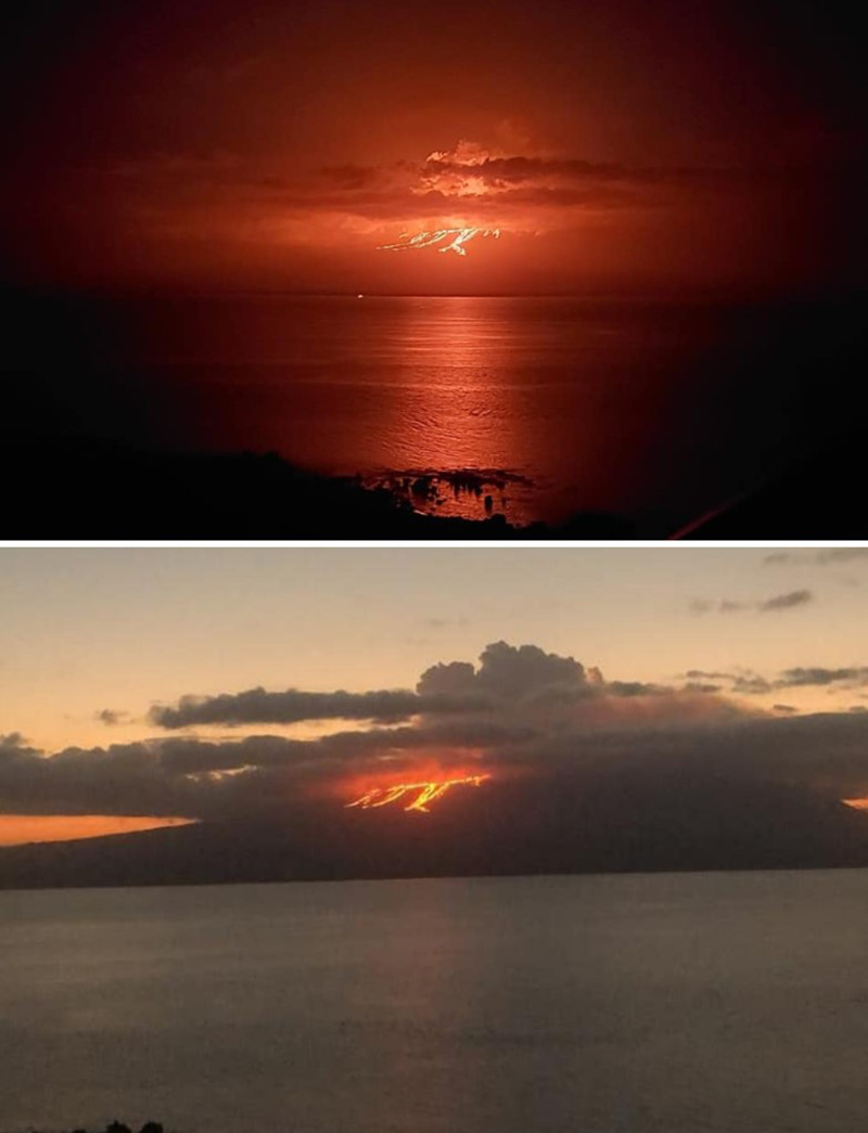 |
Figure 39. Lava flows erupting from a circumferential fissure on the eastern flank of Fernandina on 12 January 2020. Photos courtesy of Parque Nacional Galápagos. |
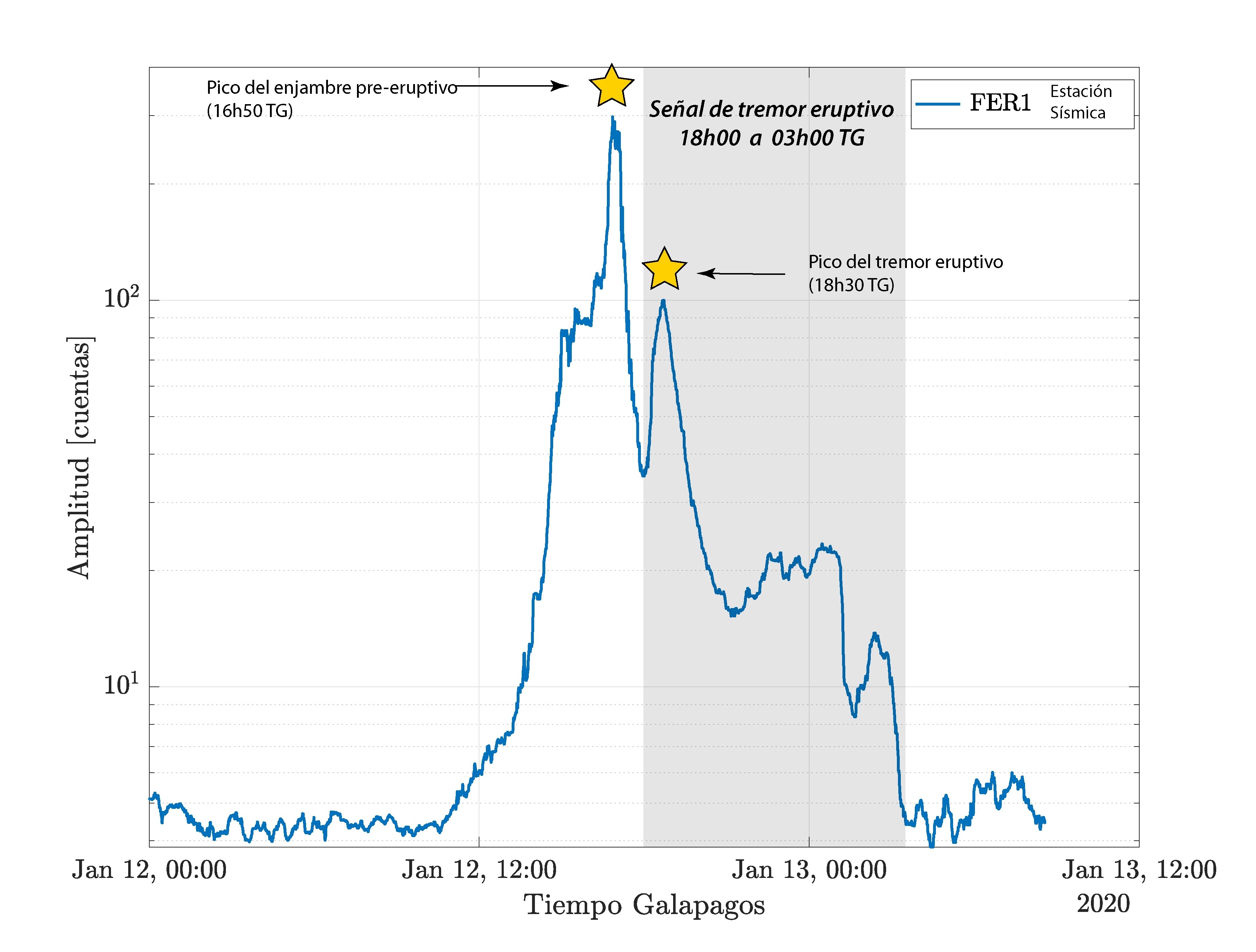 |
Figure 40. Graph showing the Root-Mean-Square (RMS) amplitude of the seismic signals from the FER-1 station at Fernandina on 12-13 January 2020. The graph shows the increase in seismicity leading to the eruption on the 12th (left star), a decrease in the seismicity, and then another increase during the event (right star). Courtesy of S. Hernandez, IG-EPN (Report on 13 January 2020). |
A report issued at 1159 local time on 13 January 2020 described a rapid decrease in seismicity, gas emissions, and thermal anomalies, indicating a rapid decline in eruptive activity similar to previous events in 2017 and 2018. An overflight that day confirmed that the eruption had ended, after lava flows had extended around 500 m from the crater and covered an area of 3.8 km2 (figures 41 and 42). Seismicity continued on the 14th, with small volcano-tectonic (VT) earthquakes occurring less than 500 m below the surface. Periodic seismicity was recorded through 13-15 January, though there was an increase in seismicity during 17-22 January with deformation also detected (figure 43). No volcanic activity followed, and no additional gas or thermal anomalies were detected.
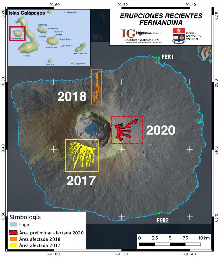 |
Figure 41. The lava flow extents at Fernandina of the previous two eruptions (4-7 September 2017 and 16-21 June 2018) and the 12-13 January 2020 eruption as detected by FIRMS thermal anomalies. Thermal data courtesy of NASA; figure prepared by F. Vásconez, IG-EPN (Report on 13 January 2020). |
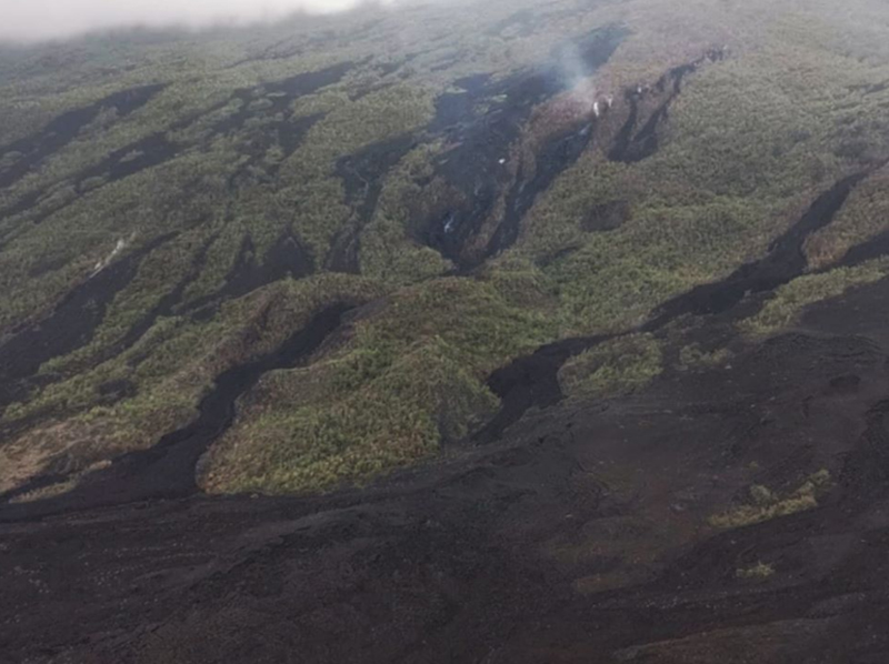 |
Figure 42. This fissure vent that formed on the E flank of Fernandina on 12 January 2020 produced several lava flows. A weak gas plume was still rising when this photo was taken the next day, but the eruption had ceased. Courtesy of Parque Nacional Galápagos. |
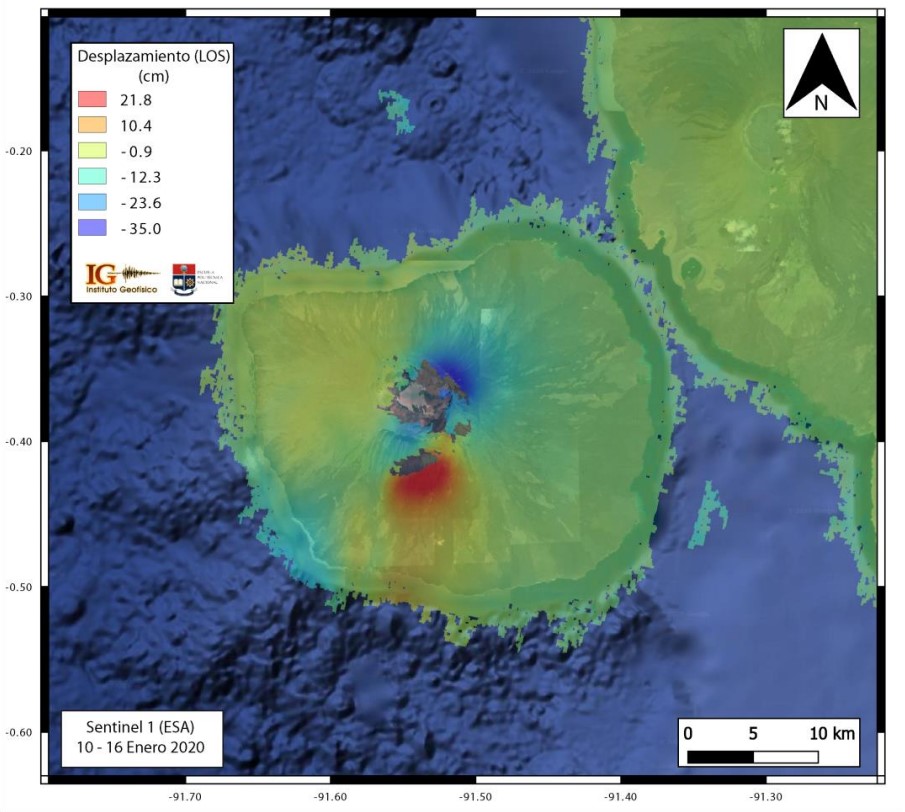 |
Figure 43. Soil displacement map for Fernandina during 10 and 16 January 2020, with the deformation generated by the 12 January eruption shown. Courtesy of IG-EPN (Report on 23 January 2020). |
Geological Summary. Fernandina, the most active of Galápagos volcanoes and the one closest to the Galápagos mantle plume, is a basaltic shield volcano with a deep 5 x 6.5 km summit caldera. The volcano displays the classic "overturned soup bowl" profile of Galápagos shield volcanoes. Its caldera is elongated in a NW-SE direction and formed during several episodes of collapse. Circumferential fissures surround the caldera and were instrumental in growth of the volcano. Reporting has been poor in this uninhabited western end of the archipelago, and even a 1981 eruption was not witnessed at the time. In 1968 the caldera floor dropped 350 m following a major explosive eruption. Subsequent eruptions, mostly from vents located on or near the caldera boundary faults, have produced lava flows inside the caldera as well as those in 1995 that reached the coast from a SW-flank vent. Collapse of a nearly 1 km3 section of the east caldera wall during an eruption in 1988 produced a debris-avalanche deposit that covered much of the caldera floor and absorbed the caldera lake.
Information Contacts: Instituto Geofísico, Escuela Politécnica Nacional (IG-EPN), Casilla 17-01-2759, Quito, Ecuador (URL: http://www.igepn.edu.ec/); Dirección del Parque Nacional Galápagos (DPNG), Isla Santa Cruz, Galápagos, Ecuador (URL: http://www.galapagos.gob.ec/).