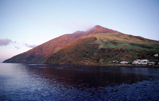
Stromboli
Italy
38.789°N, 15.213°E; summit elev. 924 m
All times are local (unless otherwise noted)
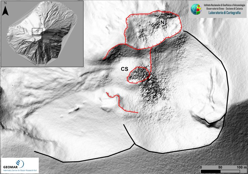
Near-constant fountains of lava at Stromboli have served as a natural beacon in the Tyrrhenian Sea for at least 2,000 years. Eruptive activity at the summit consistently occurs from multiple vents at both a north crater area (N area) and a southern crater group (CS area) on the Terrazza Craterica at the head of the Sciara del Fuoco, a large scarp that runs from the summit down the NW side of the volcano-island (figure 168). Periodic lava flows emerge from the vents and flow down the scarp, sometimes reaching the sea; occasional large explosions produce ash plumes and pyroclastic flows. Thermal and visual cameras that monitor activity at the vents are located on the nearby Pizzo Sopra La Fossa, above the Terrazza Craterica, and at multiple locations on the flanks of the volcano. Detailed information for Stromboli is provided by Italy's Istituto Nazionale di Geofisica e Vulcanologia (INGV) as well as other satellite sources of data; September-December 2019 is covered in this report.
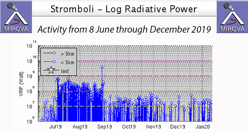
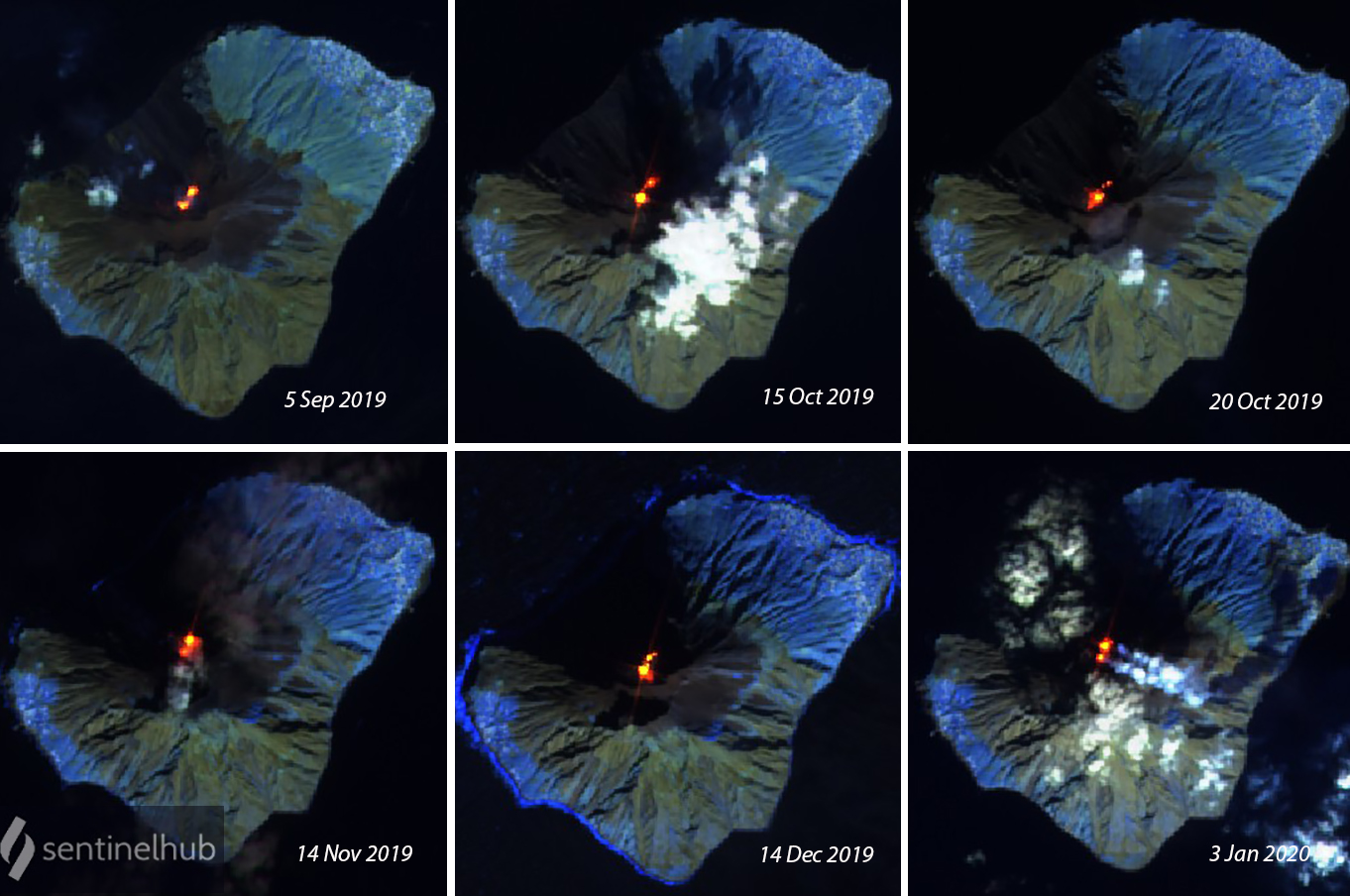
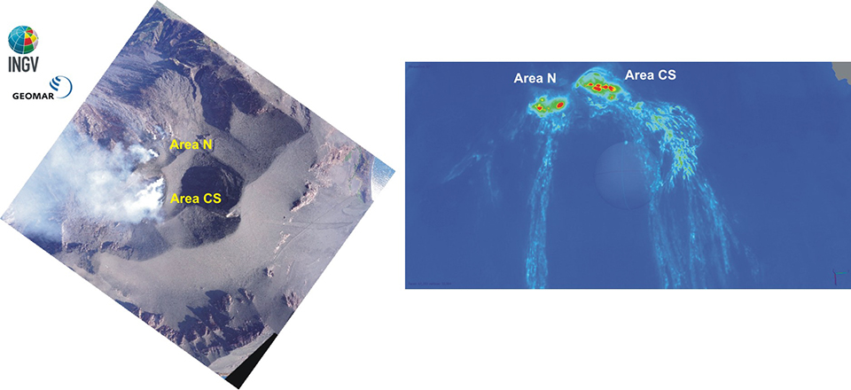
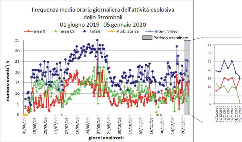
Activity was very consistent throughout the period of September-December 2019. Explosion rates ranged from 2-36 per hour and were of low to medium-high intensity, producing material that rose from less than 80 to over 150 m above the vents on occasion (table 7). The Strombolian activity in both crater areas often sent ejecta outside the crater rim onto the Terrazza Craterica, and also down the Sciara del Fuoco towards the coast. After the explosions of early July and late August, thermal activity decreased to more moderate levels that persisted throughout the period as seen in the MIROVA Log Radiative Power data (figure 169). Sentinel-2 satellite imagery supported descriptions of the constant glow at the summit, revealing incandescence at both summit areas, each showing repeating bursts of activity throughout the period (figure 170).
Table 7. Monthly summary of activity levels at Stromboli, September-December 2019. Low-intensity activity indicates ejecta rising less than 80 m, medium-intensity is ejecta rising less than 150 m, and high-intensity is ejecta rising over 200 m above the vent. Data courtesy of INGV.
| Month |
Activity |
| Sep 2019 |
Explosion rates varied from 11-36 events per hour and were of low- to medium intensity (producing 80-120 m high ejecta). Lapilli and bombs were typical from the N area, and coarse and finer-grained tephra (lapilli and ash) were most common in the CS area. The Strombolian activity in both crater areas often sent ejecta outside the crater rim onto the terrace, and also down the Sciara del Fuoco towards the coast. |
| Oct 2019 |
Typical Strombolian activity and degassing continued. Explosions rates varied from 2-21 events per hour. Low intensity activity was common in the N area (ejecta less than 80 m high) and low to moderate intensity activity was typical in the CS area, with a few explosions rising over 150 m high. Lapilli and bombs were typical from the N area, and coarse and finer-grained tephra (lapilli and ash) were most common in the CS area. Some of the explosions sent ejecta down the Sciara del Fuoco. |
| Nov 2019 |
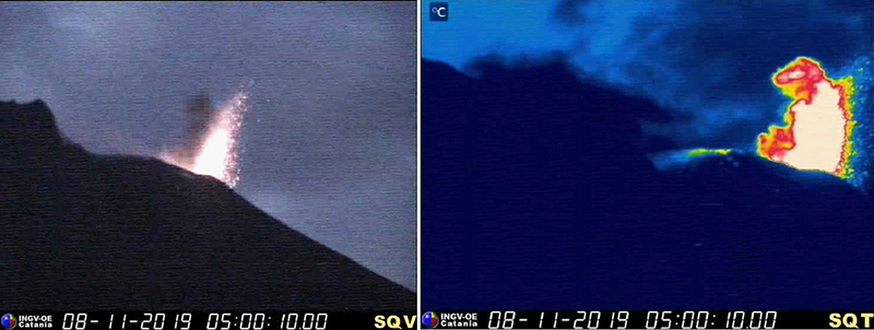
Typical Strombolian activity and degassing continued. Explosion rates varied from 11-23 events per hour with ejecta rising usually 80-150 m above the vents. Occasional explosions rose 250 m high. In the N area, explosions were generally low intensity with coarse material (lapilli and bombs). In many explosions, ejecta covered the outer slopes of the area overlooking the Sciara del Fuoco, and some blocks rolled for a few hundred meters before stopping. In the CS area, coarse material was mixed with fine and some explosions sent ejecta onto the upper part of the Sciara del Fuoco. |
| Dec 2019 |
Strombolian activity and degassing continued. Explosion rates varied from 12-26 per hour. In the N area, explosion intensity was mainly medium-low (less than 150 m) with coarse ejecta while in the CS area it was usually medium-high (more than 150 m) with both coarse and fine ejecta. In many explosions, debris covered the outer slopes of the area overlooking the Sciara del Fuoco, and some blocks rolled for a few hundred meters before stopping. Spattering activity was noted in the southern vents of the N area. |
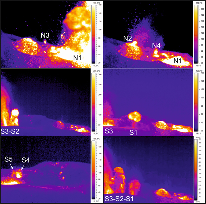
After a major explosion with a pyroclastic flow on 28 August 2019, followed by lava flows that reached the ocean in the following days (BGVN 44:09), activity diminished in early September to levels more typically seen in recent times. This included Strombolian activity from vents in both the N and CS areas that sent ejecta typically 80-150 m high. Ejecta from the N area generally consisted of lapilli and bombs, while the material from the CS area was often finer grained with significant amounts of lapilli and ash. The number of explosive events remained high in September, frequently reaching 25-30 events per hour. The ejecta periodically landed outside the craters on the Terrazza Craterica and even traveled partway down the Sciara del Fuoco. An inspection on 7 September by INGV revealed four eruptive vents in the N crater area and five in the S crater area (figure 171). The most active vents in the N area were N1 with mostly ash emissions and N2 with Strombolian explosions rich in incandescent coarse material that sometimes rose well above 150 m in height. In the S area, S1 and S2 produced jets of lava that often reached 100 m high. A small cone was observed around N2, having grown after the 28 August explosion. Between 11 and 13 September aerial surveys with drones produced detailed visual and thermal imagery of the summit (figure 172).
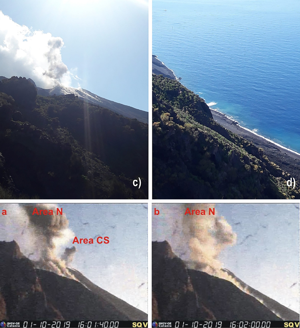
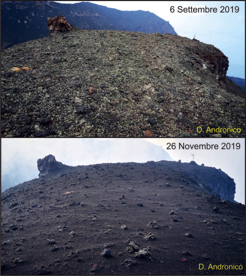
Strombolian activity from the N crater on 28 September and 1 October 2019 produced blocks and debris that rolled down the Sciara del Fuoco and reached the ocean (figure 173). Explosive activity from the CS crater area sometimes produced ejecta over 150 m high (figure 174). A survey on 26 November revealed that a layer of ash 5-10 cm thick had covered the bombs and blocks that were deposited on the Pizzo Sopra la Fossa during the explosions of 3 July and 28 August (figure 175). On the morning of 27 December a lava flow emerged from the CS area and traveled a few hundred meters down the Sciara del Fuoco. The frequency of explosive events remained relatively constant from September through December 2019 after decreasing from higher levels during July and August (figure 176).
Geological Summary. Spectacular incandescent nighttime explosions at Stromboli have long attracted visitors to the "Lighthouse of the Mediterranean" in the NE Aeolian Islands. This volcano has lent its name to the frequent mild explosive activity that has characterized its eruptions throughout much of historical time. The small island is the emergent summit of a volcano that grew in two main eruptive cycles, the last of which formed the western portion of the island. The Neostromboli eruptive period took place between about 13,000 and 5,000 years ago. The active summit vents are located at the head of the Sciara del Fuoco, a prominent scarp that formed about 5,000 years ago due to a series of slope failures which extends to below sea level. The modern volcano has been constructed within this scarp, which funnels pyroclastic ejecta and lava flows to the NW. Essentially continuous mild Strombolian explosions, sometimes accompanied by lava flows, have been recorded for more than a millennium.
Information Contacts: Istituto Nazionale di Geofisica e Vulcanologia (INGV), Sezione di Catania, Piazza Roma 2, 95123 Catania, Italy, (URL: http://www.ct.ingv.it/en/); MIROVA (Middle InfraRed Observation of Volcanic Activity), a collaborative project between the Universities of Turin and Florence (Italy) supported by the Centre for Volcanic Risk of the Italian Civil Protection Department (URL: http://www.mirovaweb.it/); Sentinel Hub Playground (URL: https://www.sentinel-hub.com/explore/sentinel-playground).