Report on Taal (Philippines) — June 2020

Bulletin of the Global Volcanism Network, vol. 45, no. 6 (June 2020)
Managing Editor: Edward Venzke.
Edited by Janine B. Krippner.
Taal (Philippines) Eruption on 12 January with explosions through 22 January; steam plumes continuing into March
Please cite this report as:
Global Volcanism Program, 2020. Report on Taal (Philippines) (Krippner, J.B., and Venzke, E., eds.). Bulletin of the Global Volcanism Network, 45:6. Smithsonian Institution. https://doi.org/10.5479/si.GVP.BGVN202006-273070
Taal
Philippines
14.0106°N, 120.9975°E; summit elev. 311 m
All times are local (unless otherwise noted)
Taal volcano is in a caldera system located in southern Luzon island and is one of the most active volcanoes in the Philippines. It has produced around 35 recorded eruptions since 3,580 BCE, ranging from VEI 1 to 6, with the majority of eruptions being a VEI 2. The caldera contains a lake with an island that also contains a lake within the Main Crater (figure 12). Prior to 2020 the most recent eruption was in 1977, on the south flank near Mt. Tambaro. The United Nations Office for the Coordination of Humanitarian Affairs in the Philippines reports that over 450,000 people live within 40 km of the caldera (figure 13). This report covers activity during January through February 2020 including the 12 to 22 January eruption, and is based on reports by Philippine Institute of Volcanology and Seismology (PHIVOLCS), satellite data, geophysical data, and media reports.
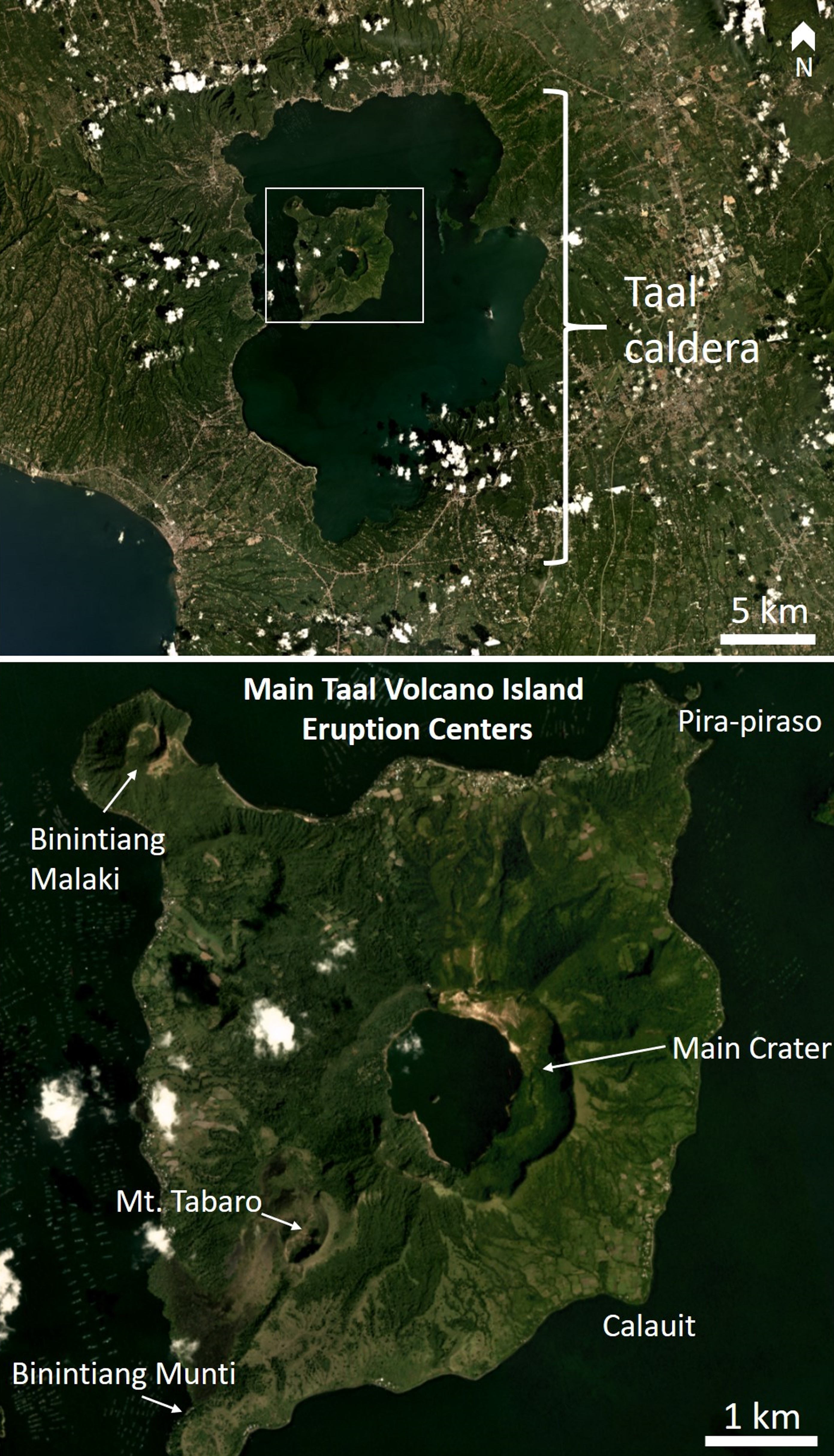 |
Figure 12. Annotated satellite images showing the Taal caldera, Volcano Island in the caldera lake, and features on the island including Main Crater. Imagery courtesy of Planet Inc. |
 |
Figure 13. Map showing population totals within 14 and 17 km of Volcano Island at Taal. Courtesy of the United Nations Office for the Coordination of Humanitarian Affairs (OCHA). |
The hazard status at Taal was raised to Alert Level 1 (abnormal, on a scale of 0-5) on 28 March 2019. From that date through to 1 December there were 4,857 earthquakes registered, with some felt nearby. Inflation was detected during 21-29 November and an increase in CO2 emission within the Main Crater was observed. Seismicity increased beginning at 1100 on 12 January. At 1300 there were phreatic (steam) explosions from several points inside Main Crater and the Alert Level was raised to 2 (increasing unrest). Booming sounds were heard in Talisay, Batangas, at 1400; by 1402 the plume had reached 1 km above the crater, after which the Alert Level was raised to 3 (magmatic unrest).
Phreatic eruption on 12 January 2020. A seismic swarm began at 1100 on 12 January 2020 followed by a phreatic eruption at 1300. The initial activity consisted of steaming from at least five vents in Main Crater and phreatic explosions that generated 100-m-high plumes. PHIVOLCS raised the Alert Level to 2. The Earth Observatory of Singapore reported that the International Data Center (IDC) for the Comprehensive test Ban Treaty (CTBT) in Vienna noted initial infrasound detections at 1450 that day.
Booming sounds were heard at 1400 in Talisay, Batangas (4 km NNE from the Main Crater), and at 1404 volcanic tremor and earthquakes felt locally were accompanied by an eruption plume that rose 1 km; ash fell to the SSW. The Alert Level was raised to 3 and the evacuation of high-risk barangays was recommended. Activity again intensified around 1730, prompting PHIVOLCS to raise the Alert Level to 4 and recommend a total evacuation of the island and high-risk areas within a 14-km radius. The eruption plume of steam, gas, and tephra significantly intensified, rising to 10-15 km altitude and producing frequent lightning (figures 14 and 15). Wet ash fell as far away as Quezon City (75 km N). According to news articles schools and government offices were ordered to close and the Ninoy Aquino International Airport (56 km N) in Manila suspended flights. About 6,000 people had been evacuated. Residents described heavy ashfall, low visibility, and fallen trees.
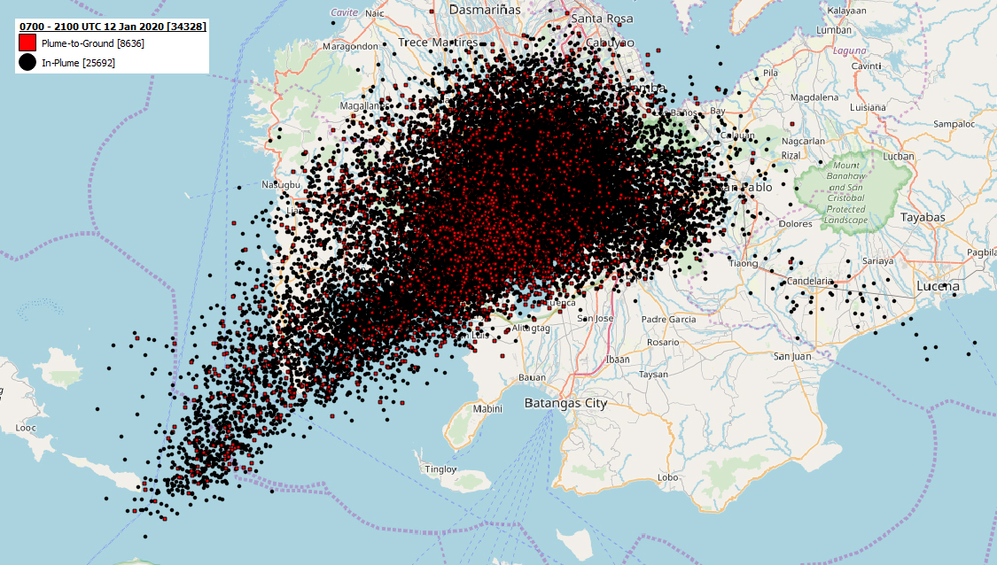 |
Figure 14. Lightning produced during the eruption of Taal during 1500 on 12 January to 0500 on 13 January 2020 local time (0700-2100 UTC on 12 January). Courtesy of Chris Vagasky, Vaisala. |
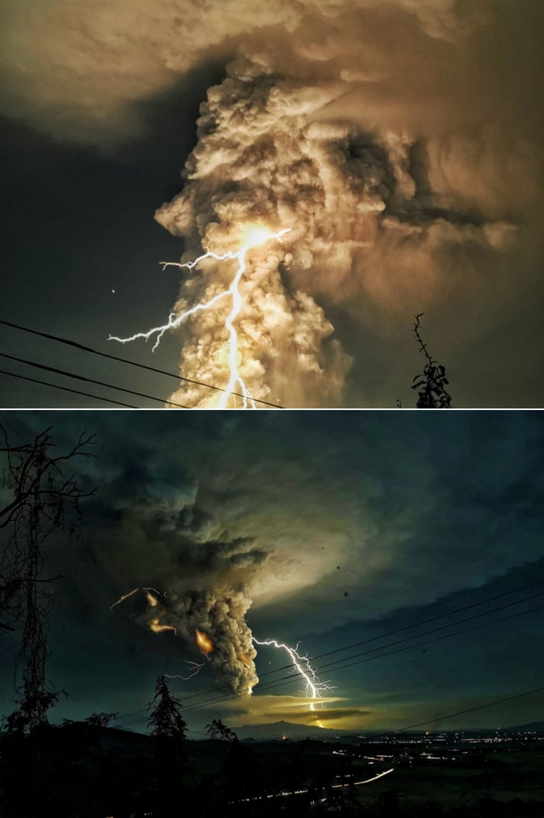 |
Figure 15. Lightning strokes produced during the first days of the Taal January 2020 eruption. Courtesy of Domcar C Lagto/SIPA/REX/Shutterstock via The Guardian. |
In a statement issued at 0320 on 13 January, PHIVOLCS noted that ashfall had been reported across a broad area to the north in Tanauan (18 km NE), Batangas; Escala (11 km NW), Tagaytay; Sta. Rosa (32 km NNW), Laguna; Dasmariñas (32 km N), Bacoor (44 km N), and Silang (22 km N), Cavite; Malolos (93 km N), San Jose Del Monte (87 km N), and Meycauayan (80 km N), Bulacan; Antipolo (68 km NNE), Rizal; Muntinlupa (43 km N), Las Piñas (47 km N), Marikina (70 km NNE), Parañaque (51 km N), Pasig (62 km NNE), Quezon City, Mandaluyong (62 km N), San Juan (64 km N), Manila; Makati City (59 km N) and Taguig City (55 km N). Lapilli (2-64 mm in diameter) fell in Tanauan and Talisay; Tagaytay City (12 km N); Nuvali (25 km NNE) and Sta (figure 16). Rosa, Laguna. Felt earthquakes (Intensities II-V) continued to be recorded in local areas.
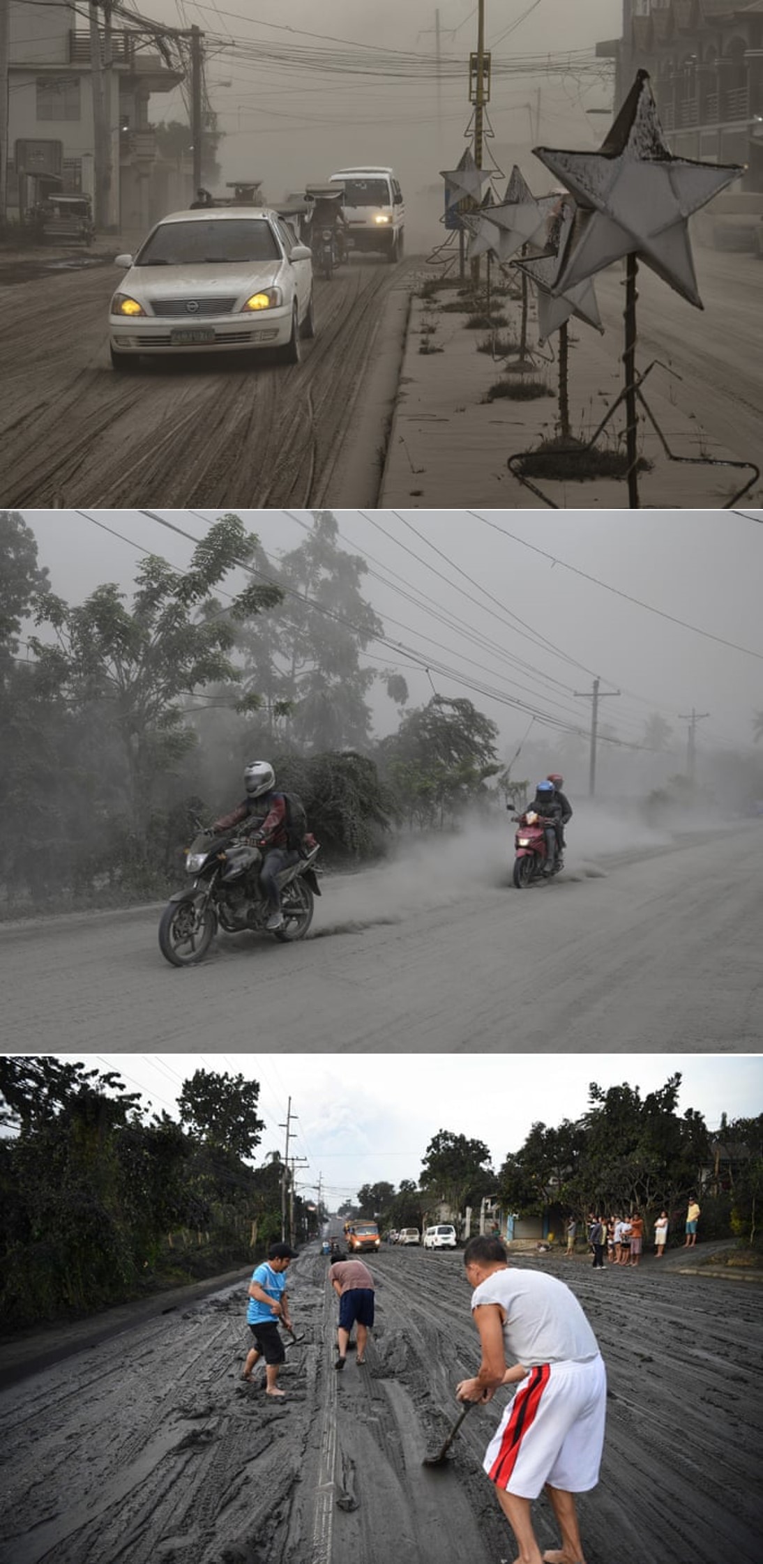 |
Figure 16. Ashfall from the Taal January 2020 eruption in Lemery (top) and in the Batangas province (bottom). Photos posted on 13 January, courtesy of Ezra Acayan/Getty Images, Aaron Favila/AP, and Ted Aljibe/AFP via Getty Images via The Guardian. |
Magmatic eruption on 13 January 2020. A magmatic eruption began during 0249-0428 on 13 January, characterized by weak lava fountaining accompanied by thunder and flashes of lightning. Activity briefly waned then resumed with sporadic weak fountaining and explosions that generated 2-km-high, dark gray, steam-laden ash plumes (figure 17). New lateral vents opened on the N flank, producing 500-m-tall lava fountains. Heavy ashfall impacted areas to the SW, including in Cuenca (15 km SSW), Lemery (16 km SW), Talisay, and Taal (15 km SSW), Batangas (figure 18).
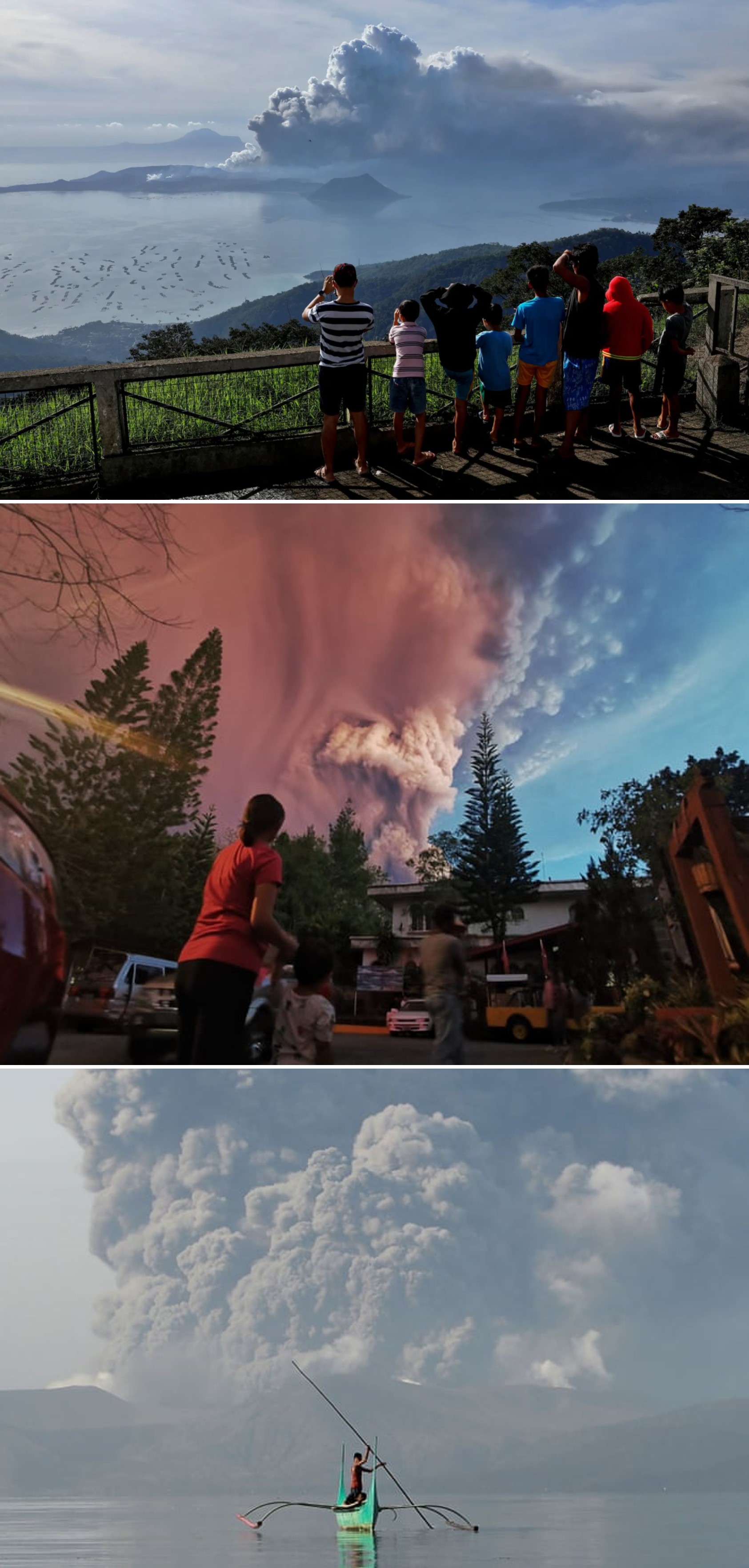 |
Figure 17. Ash plumes seen from various points around Taal in the initial days of the January 2020 eruption, posted on 13 January. Courtesy of Eloisa Lopez/Reuters, Kester Ragaza/Pacific Press/Shutterstock, Ted Aljibe/AFP via Getty Images, via The Guardian. |
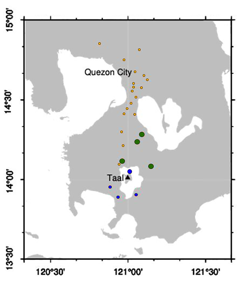 |
Figure 18. Map indicating areas impacted by ashfall from the 12 January eruption through to 0800 on the 13th. Small yellow circles (to the N) are ashfall report locations; blue circles (at the island and to the S) are heavy ashfall; large green circles are lapilli (particles measuring 2-64 mm in diameter). Modified from a map courtesy of Lauriane Chardot, Earth Observatory of Singapore; data taken from PHIVOLCS. |
News articles noted that more than 300 domestic and 230 international flights were cancelled as the Manila Ninoy Aquino International Airport was closed during 12-13 January. Some roads from Talisay to Lemery and Agoncillo were impassible and electricity and water services were intermittent. Ashfall in several provinces caused power outages. Authorities continued to evacuate high-risk areas, and by 13 January more than 24,500 people had moved to 75 shelters out of a total number of 460,000 people within 14 km.
A PHIVOLCS report for 0800 on the 13th through 0800 on 14 January noted that lava fountaining had continued, with steam-rich ash plumes reaching around 2 km above the volcano and dispersing ash SE and W of Main Crater. Volcanic lighting continued at the base of the plumes. Fissures on the N flank produced 500-m-tall lava fountains. Heavy ashfall continued in the Lemery, Talisay, Taal, and Cuenca, Batangas Municipalities. By 1300 on the 13th lava fountaining generated 800-m-tall, dark gray, steam-laden ash plumes that drifted SW. Sulfur dioxide emissions averaged 5,299 metric tons/day (t/d) on 13 January and dispersed NNE (figure 19).
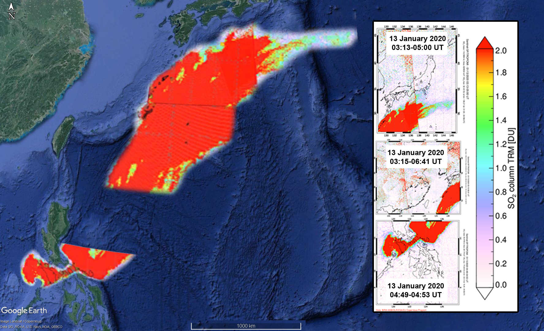 |
Figure 19. Compilation of sulfur dioxide plumes from TROPOMI overlaid in Google Earth for 13 January from 0313-1641 UT. Courtesy of NASA Global Sulfur Dioxide Monitoring Page and Google Earth. |
Explosions and ash emission through 22 January 2020. At 0800 on 15 January PHIVOLCS stated that activity was generally weaker; dark gray, steam-laden ash plumes rose about 1 km and drifted SW. Satellite images showed that the Main Crater lake was gone and new craters had formed inside Main Crater and on the N side of Volcano Island.
PHIVOLCS reported that activity during 15-16 January was characterized by dark gray, steam-laden plumes that rose as high as 1 km above the vents in Main Crater and drifted S and SW. Sulfur dioxide emissions were 4,186 t/d on 15 January. Eruptive events at 0617 and 0621 on 16 January generated short-lived, dark gray ash plumes that rose 500 and 800 m, respectively, and drifted SW. Weak steam plumes rose 800 m and drifted SW during 1100-1700, and nine weak explosions were recorded by the seismic network.
Steady steam emissions were visible during 17-21 January. Infrequent weak explosions generated ash plumes that rose as high as 1 km and drifted SW. Sulfur dioxide emissions fluctuated and were as high as 4,353 t/d on 20 January and as low as 344 t/d on 21 January. PHIVOLCS reported that white steam-laden plumes rose as high as 800 m above main vent during 22-28 January and drifted SW and NE; ash emissions ceased around 0500 on 22 January. Remobilized ash drifted SW on 22 January due to strong low winds, affecting the towns of Lemery (16 km SW) and Agoncillo, and rose as high as 5.8 km altitude as reported by pilots. Sulfur dioxide emissions were low at 140 t/d.
Steam plumes through mid-April 2020. The Alert Level was lowered to 3 on 26 January and PHIVOLCS recommended no entry onto Volcano Island and Taal Lake, nor into towns on the western side of the island within a 7-km radius. PHIVOLCS reported that whitish steam plumes rose as high as 800 m during 29 January-4 February and drifted SW (figure 20). The observed steam plumes rose as high as 300 m during 5-11 February and drifted SW.
Sulfur dioxide emissions averaged around 250 t/d during 22-26 January; emissions were 87 t/d on 27 January and below detectable limits the next day. During 29 January-4 February sulfur dioxide emissions ranged to a high of 231 t/d (on 3 February). The following week sulfur dioxide emissions ranged from values below detectable limits to a high of 116 t/d (on 8 February).
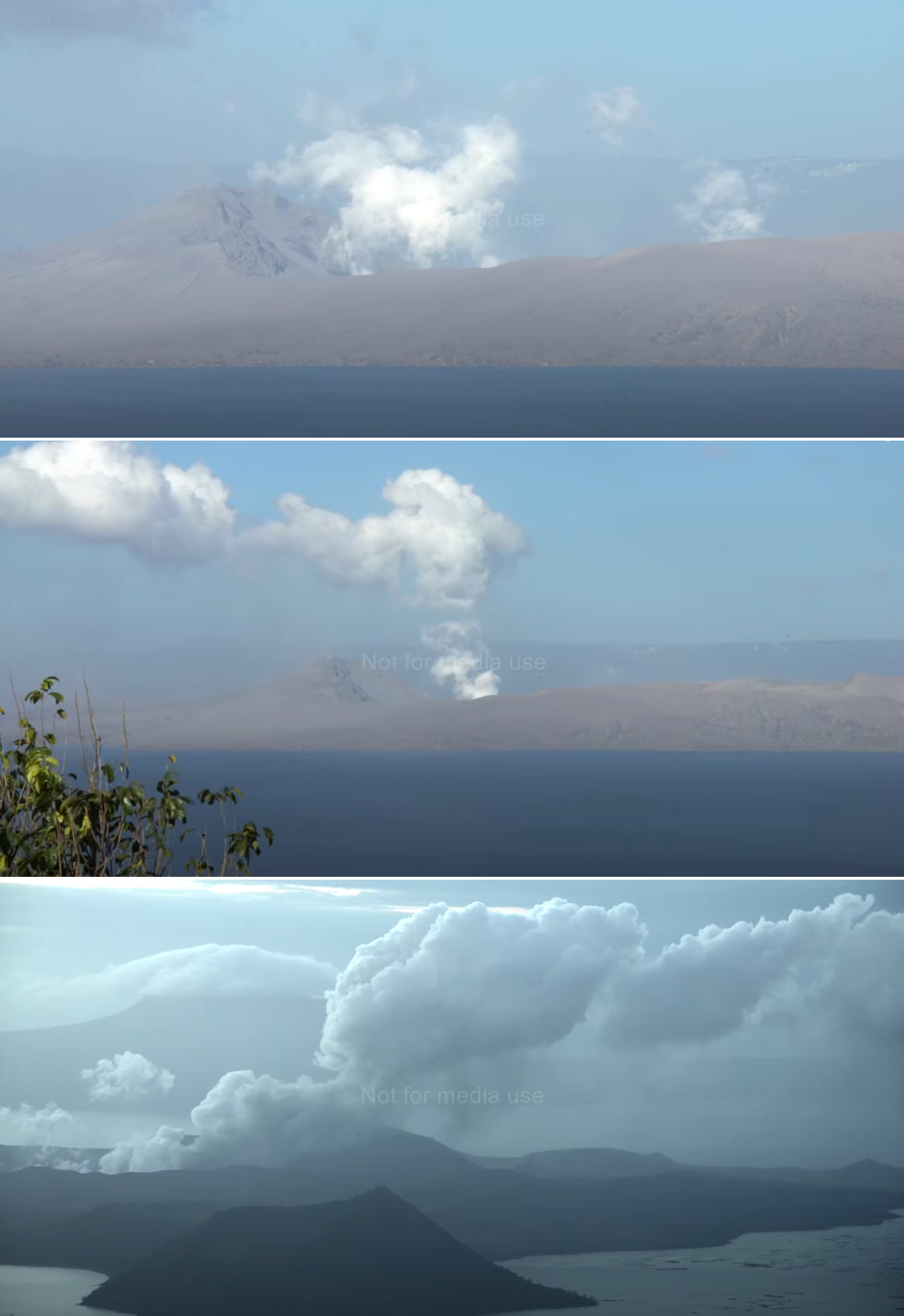 |
Figure 20. Taal Volcano Island producing gas-and-steam plumes on 15-16 January 2020. Courtesy of James Reynolds, Earth Uncut. |
On 14 February PHIVOLCS lowered the Alert Level to 2, noting a decline in the number of volcanic earthquakes, stabilizing ground deformation of the caldera and Volcano Island, and diffuse steam-and-gas emission that continued to rise no higher than 300 m above the main vent during the past three weeks. During 14-18 February sulfur dioxide emissions ranged from values below detectable limits to a high of 58 tonnes per day (on 16 February). Sulfur dioxide emissions were below detectable limits during 19-20 February. During 26 February-2 March steam plumes rose 50-300 m above the vent and drifted SW and NE. PHIVOLCS reported that during 4-10 March weak steam plumes rose 50-100 m and drifted SW and NE; moderate steam plumes rose 300-500 m and drifted SW during 8-9 March. During 11-17 March weak steam plumes again rose only 50-100 m and drifted SW and NE.
PHIVOLCS lowered the Alert Level to 1 on 19 March and recommended no entry onto Volcano Island, the area defined as the Permanent Danger Zone. During 8-9 April steam plumes rose 100-300 m and drifted SW. As of 1-2 May 2020 only weak steaming and fumarolic activity from fissure vents along the Daang Kastila trail was observed.
Evacuations. According to the Disaster Response Operations Monitoring and Information Center (DROMIC) there were a total of 53,832 people dispersed to 244 evacuation centers by 1800 on 15 January. By 21 January there were 148,987 people in 493 evacuation. The number of residents in evacuation centers dropped over the next week to 125,178 people in 497 locations on 28 January. However, many residents remained displaced as of 3 February, with DROMIC reporting 23,915 people in 152 evacuation centers, but an additional 224,188 people staying at other locations.
By 10 February there were 17,088 people in 110 evacuation centers, and an additional 211,729 staying at other locations. According to the DROMIC there were a total of 5,321 people in 21 evacuation centers, and an additional 195,987 people were staying at other locations as of 19 February.
The number of displaced residents continued to drop, and by 3 March there were 4,314 people in 12 evacuation centers, and an additional 132,931 people at other locations. As of 11 March there were still 4,131 people in 11 evacuation centers, but only 17,563 staying at other locations.
Deformation and ground cracks. New ground cracks were observed on 13 January in Sinisian (18 km SW), Mahabang Dahilig (14 km SW), Dayapan (15 km SW), Palanas (17 km SW), Sangalang (17 km SW), and Poblacion (19 km SW) Lemery; Pansipit (11 km SW), Agoncillo; Poblacion 1, Poblacion 2, Poblacion 3, Poblacion 5 (all around 17 km SW), Talisay, and Poblacion (11 km SW), San Nicolas (figure 21). A fissure opened across the road connecting Agoncillo to Laurel, Batangas. New ground cracking was reported the next day in Sambal Ibaba (17 km SW), and portions of the Pansipit River (SW) had dried up.
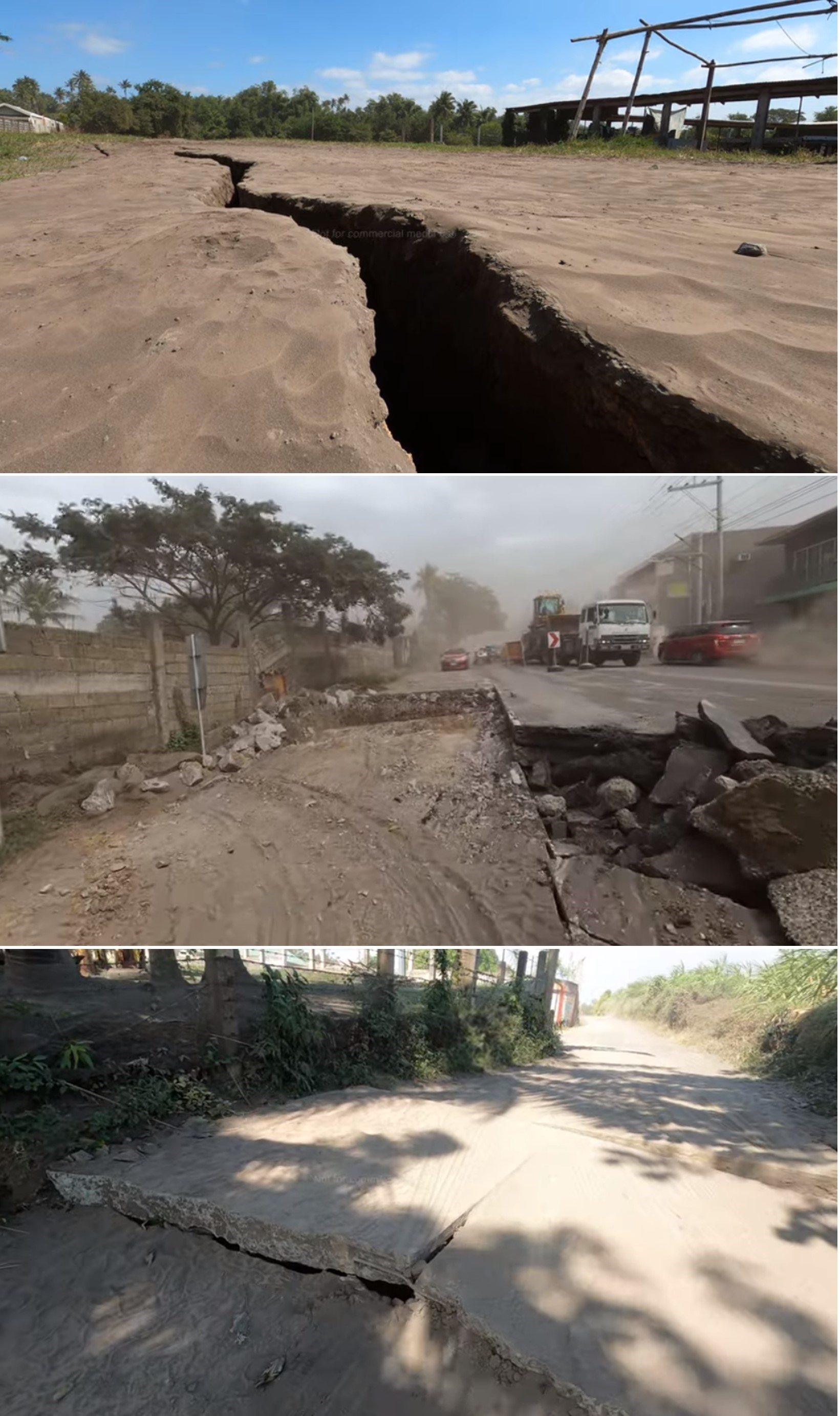 |
Figure 21. Video screenshots showing ground cracks that formed during the Taal unrest and captured on 15 and 16 January 2020. Courtesy of James Reynolds, Earth Uncut. |
Dropping water levels of Taal Lake were first observed in some areas on 16 January but reported to be lake-wide the next day. The known ground cracks in the barangays of Lemery, Agoncillo, Talisay, and San Nicolas in Batangas Province widened a few centimeters by 17 January, and a new steaming fissure was identified on the N flank of the island.
GPS data had recorded a sudden widening of the caldera by ~1 m, uplift of the NW sector by ~20 cm, and subsidence of the SW part of Volcano Island by ~1 m just after the main eruption phase. The rate of deformation was smaller during 15-22 January, and generally corroborated by field observations; Taal Lake had receded about 30 cm by 25 January but about 2.5 m of the change (due to uplift) was observed around the SW portion of the lake, near the Pansipit River Valley where ground cracking had been reported.
Weak steaming (plumes 10-20 m high) from ground cracks was visible during 5-11 February along the Daang Kastila trail which connects the N part of Volcano Island to the N part of the main crater. PHIVOLCS reported that during 19-24 February steam plumes rose 50-100 m above the vent and drifted SW. Weak steaming (plumes up to 20 m high) from ground cracks was visible during 8-14 April along the Daang Kastila trail which connects the N part of Volcano Island to the N part of the main crater.
Seismicity. Between 1300 on 12 January and 0800 on 21 January the Philippine Seismic Network (PSN) had recorded a total of 718 volcanic earthquakes; 176 of those had magnitudes ranging from 1.2-4.1 and were felt with Intensities of I-V. During 20-21 January there were five volcanic earthquakes with magnitudes of 1.6-2.5; the Taal Volcano network (which can detect smaller events not detectable by the PSN) recorded 448 volcanic earthquakes, including 17 low-frequency events. PHIVOLCS stated that by 21 January hybrid earthquakes had ceased and both the number and magnitude of low-frequency events had diminished.
Geological Summary. Taal is one of the most active volcanoes in the Philippines and has produced some powerful eruptions. The 15 x 20 km Talisay (Taal) caldera is largely filled by Lake Taal, whose 267 km2 surface lies only 3 m above sea level. The maximum depth of the lake is 160 m, with several submerged eruptive centers. The 5-km-wide Volcano Island in north-central Lake Taal is the location of all observed eruptions. The island is composed of coalescing small stratovolcanoes, tuff rings, and scoria cones. Powerful pyroclastic flows and surges have caused many fatalities.
Information Contacts: Philippine Institute of Volcanology and Seismology (PHIVOLCS), Department of Science and Technology, University of the Philippines Campus, Diliman, Quezon City, Philippines (URL: http://www.phivolcs.dost.gov.ph/); Disaster Response Operations Monitoring and Information Center (DROMIC) (URL: https://dromic.dswd.gov.ph/); United Nations Office for the Coordination of Humanitarian Affairs, Philippines (URL: https://www.unocha.org/philippines); James Reynolds, Earth Uncut TV (Twitter: @EarthUncutTV, URL: https://www.earthuncut.tv/, YouTube: https://www.youtube.com/user/TyphoonHunter); Chris Vagasky, Vaisala Inc., Louisville, Colorado, USA (URL: https://www.vaisala.com/en?type=1, Twitter: @COweatherman, URL: https://twitter.com/COweatherman); Earth Observatory of Singapore, Nanyang Technological University, 50 Nanyang Avenue, Singapore (URL: https://www.earthobservatory.sg/); Global Sulfur Dioxide Monitoring Page, Atmospheric Chemistry and Dynamics Laboratory, NASA Goddard Space Flight Center (NASA/GSFC), 8800 Greenbelt Road, Goddard, Maryland, USA (URL: https://so2.gsfc.nasa.gov/); Relief Web, Flash Update No. 1 - Philippines: Taal Volcano eruption (As of 13 January 2020, 2 p.m. local time) (URL: https://reliefweb.int/report/philippines/flash-update-no-1-philippines-taal-volcano-eruption-13-january-2020-2-pm-local); Bloomberg, Philippines Braces for Hazardous Volcano Eruption (URL: https://www.bloomberg.com/news/articles/2020-01-12/philippines-raises-alert-level-in-taal-as-volcano-spews-ash); National Public Radio (NPR), Volcanic Eruption In Philippines Causes Thousands To Flee (URL: npr.org/2020/01/13/795815351/volcanic-eruption-in-philippines-causes-thousands-to-flee); Reuters (http://www.reuters.com/); Agence France-Presse (URL: http://www.afp.com/); Pacific Press (URL: http://www.pacificpress.com/); Shutterstock (URL: https://www.shutterstock.com/); Getty Images (URL: http://www.gettyimages.com/); Google Earth (URL: https://www.google.com/earth/).