Report on Masaya (Nicaragua) — June 2020

Bulletin of the Global Volcanism Network, vol. 45, no. 6 (June 2020)
Managing Editor: Edward Venzke.
Research and preparation by Paul Berger.
Masaya (Nicaragua) Lava lake level drops but remains active through May 2020; weak gas plumes
Please cite this report as:
Global Volcanism Program, 2020. Report on Masaya (Nicaragua) (Venzke, E., ed.). Bulletin of the Global Volcanism Network, 45:6. Smithsonian Institution. https://doi.org/10.5479/si.GVP.BGVN202006-344100
Masaya
Nicaragua
11.9844°N, 86.1688°W; summit elev. 594 m
All times are local (unless otherwise noted)
Masaya, which is about 20 km NW of the Nicaragua’s capital of Managua, is one of the most active volcanoes in that country and has a caldera that contains a number of craters (BGVN 43:11). The Santiago crater is the one most currently active and it contains a small lava lake that emits weak gas plumes (figure 85). This report summarizes activity during February through May 2020 and is based on Instituto Nicaragüense de Estudios Territoriales (INETER) monthly reports and satellite data. During the reporting period, the volcano was relatively calm, with only weak gas plumes.
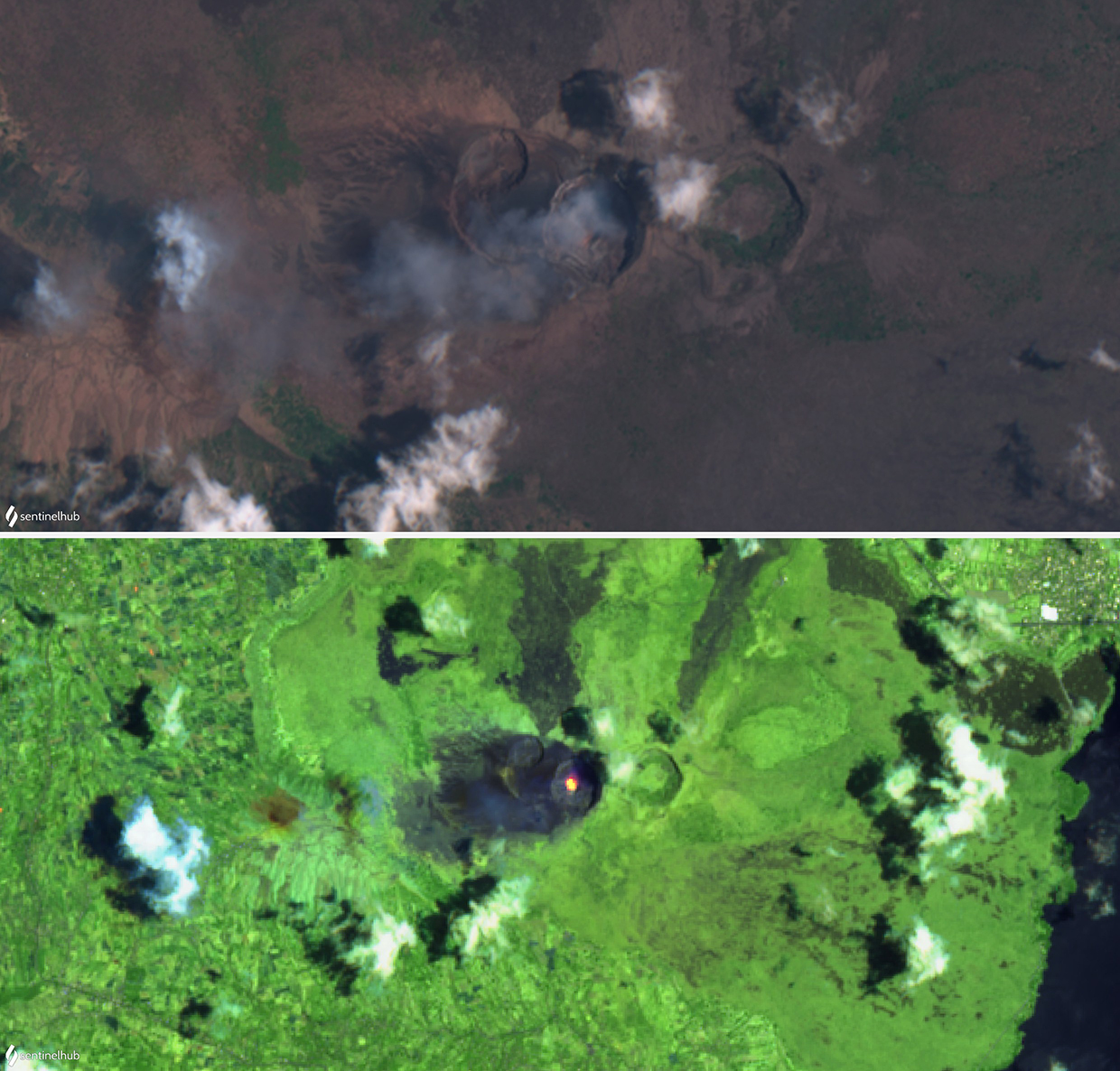 |
Figure 85. Satellite images of Masaya from Sentinel-2 on 18 April 2020, showing and a small gas plume drifting SW (top, natural color bands 4, 3, 2) and the lava lake (bottom, false color bands 12, 11, 4). Courtesy of Sentinel Hub Playground. |
According to INETER, thermal images of the lava lake and temperature data in the fumaroles were taken using an Omega infrared gun and a forward-looking infrared (FLIR) SC620 thermal camera. The temperatures above the lava lake have decreased since November 2019, when the temperature was 287°C, dropping to 96°C when measured on 14 May 2020. INETER attributed this decrease to subsidence in the level of the lava lake by 5 m which obstructed part of the lake and concentrated the gas emissions in the weak plume. Convection continued in the lava lake, which in May had decreased to a diameter of 3 m. Many landslides had occurred in the E, NE, and S walls of the crater rim due to rock fracturing caused by the high heat and acidity of the emissions.
During the reporting period, the MIROVA (Middle InfraRed Observation of Volcanic Activity) volcano hotspot detection system recorded numerous thermal anomalies from the lava lake based on MODIS data (figure 86). Infrared satellite images from Sentinel-2 regularly showed a strong signature from the lava lake through 18 May, after which the volcano was covered by clouds.
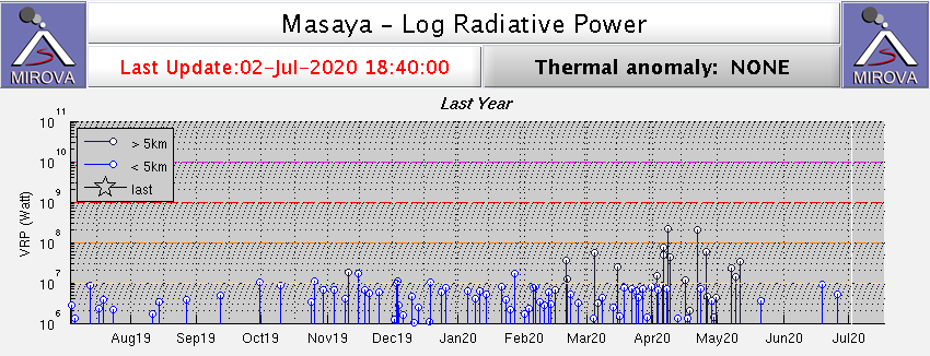 |
Figure 86. Thermal anomalies at Masaya during February through May 2020. The larger anomalies with black lines are more distant and not related to the volcano. Courtesy of MIROVA. |
Measurements of sulfur dioxide (SO2) made by INETER in the section of the Ticuantepe - La Concepción highway (just W of the volcano) with a mobile DOAS system varied between a low of just over 1,000 metric tons/day in mid-November 2019 to a high of almost 2,500 tons/day in late May. Temperatures of fumaroles in the Cerro El Comalito area, just ENE of Santiago crater, ranged from 58 to 76°C during February-May 2020, with most values in the 69-72°C range.
Geological Summary. Masaya volcano in Nicaragua has erupted frequently since the time of the Spanish Conquistadors, when an active lava lake prompted attempts to extract the volcano's molten "gold" until it was found to be basalt rock upon cooling. It lies within the massive Pleistocene Las Sierras caldera and is itself a broad, 6 x 11 km basaltic caldera with steep-sided walls up to 300 m high. The caldera is filled on its NW end by more than a dozen vents that erupted along a circular, 4-km-diameter fracture system. The Nindirí and Masaya cones, the source of observed eruptions, were constructed at the southern end of the fracture system and contain multiple summit craters, including the currently active Santiago crater. A major basaltic Plinian tephra erupted from Masaya about 6,500 years ago. Recent lava flows cover much of the caldera floor and there is a lake at the far eastern end. A lava flow from the 1670 eruption overtopped the north caldera rim. Periods of long-term vigorous gas emission at roughly quarter-century intervals have caused health hazards and crop damage.
Information Contacts: Instituto Nicaragüense de Estudios Territoriales (INETER), Apartado Postal 2110, Managua, Nicaragua (URL: http://www.ineter.gob.ni/); MIROVA (Middle InfraRed Observation of Volcanic Activity), a collaborative project between the Universities of Turin and Florence (Italy) supported by the Centre for Volcanic Risk of the Italian Civil Protection Department (URL: http://www.mirovaweb.it/); Sentinel Hub Playground (URL: https://www.sentinel-hub.com/explore/sentinel-playground).