Report on Nevado del Ruiz (Colombia) — January 2021

Bulletin of the Global Volcanism Network, vol. 46, no. 1 (January 2021)
Managing Editor: Edward Venzke.
Edited by A. Elizabeth Crafford.
Nevado del Ruiz (Colombia) Dome growth and ash emissions continue during July-December 2020
Please cite this report as:
Global Volcanism Program, 2021. Report on Nevado del Ruiz (Colombia) (Crafford, A.E., and Venzke, E., eds.). Bulletin of the Global Volcanism Network, 46:1. Smithsonian Institution. https://doi.org/10.5479/si.GVP.BGVN202101-351020
Nevado del Ruiz
Colombia
4.892°N, 75.324°W; summit elev. 5279 m
All times are local (unless otherwise noted)
Colombia’s broad, glacier-capped Nevado del Ruiz has an eruption history documented back 8,600 years, including documented observations since 1570. Ruiz remained quiet for 20 years after the deadly September 1985-July 1991 eruption until a period of explosive activity from February 2012 into 2013. Renewed activity beginning in November 2014 included ash and gas-and-steam plumes, ashfall, and the appearance of a slowly growing lava dome inside the Arenas crater in August 2015. Additional information has caused a revision to earlier reporting that eruptive activity ended in May 2017 and began again that December (BGVN 44:12); activity appears to have continued throughout 2017 with intermittent ash emissions and thermal evidence of dome growth. Periods of increased thermal activity alternated with periods of increased explosive activity during 2018-2019 and into 2020; SO2 emissions persisted at significant levels. The lava dome has continued to grow through 2020. This report covers ongoing activity from July-December 2020 using information from reports by the Servicio Geologico Colombiano (SGC) and the Observatorio Vulcanológico y Sismológico de Manizales, the Washington Volcanic Ash Advisory Center (VAAC) notices, and various sources of satellite data.
Gas and ash emissions continued throughout July-December 2020; they generally rose to 5.8-6.1 km altitude with the highest reported plume at 6.7 km altitude on 7 December. SGC interpreted repeated episodes of “drumbeat seismicity” as an indication of continued dome growth throughout the period. Satellite thermal anomalies also suggested that dome growth continued. The MIROVA graph of thermal activity suggests that the dome was quiet in July and early August, but small pulses of thermal energy were recorded every few weeks for the remainder of 2020 (figure 115). Plots of the cumulative number and magnitude of seismic events at Nevado del Ruiz between January 2010 and November 2020 show a stable trend with periodic sharp increases in activity or magnitude throughout that time. SGC has adjusted the warning levels over time according to changes in the slope of the curves (figure 116).
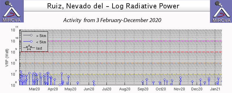 |
Figure 115. Thermal energy shown in the MIROVA graph of log radiative power at Nevado del Ruiz from 3 February 2020 through the end of the year indicates that higher levels of thermal energy lasted through April 2020; a quieter period from late May-early August was followed by low-level persistent anomalies through the end of the year. Courtesy of MIROVA. |
 |
Figure 116. Changes in seismic frequency and energy at Nevado del Ruiz have been monitored by SGC for many years. Left: the cumulative number of daily VT, LP-VLP, TR, and HB seismic events, recorded between 1 January 2010 and 30 November 2020. The arrows highlight the days with the highest number of seismic events; the number and type of event is shown under the date. Right: The cumulative VT and HB seismic energy recorded between 1 January 2010 and 30 November 2020. The arrows highlight the days with the highest energy; the local magnitude of the event is shown below the date. SGC has adjusted the warning levels over time (bar across the bottom of each graph) according to changes in the slope of the curves. Courtesy of SGC (INFORME TÉCNICO – OPERATIVO DE LA ACTIVIDAD VOLCÁNICA, SEGMENTO VOLCÁNICO NORTE DE COLOMBIA – NOVIEMBRE DE 2020). |
Activity during July-December 2020. Seismic energy increased during July compared to June 2020 with events localized around the Arenas crater. The depth of the seismicity varied from 0.3-7.8 km. Some of these signals were associated with small emissions of gas and ash, which were confirmed through webcams and by reports from officials of the Los Nevados National Natural Park (NNNP). The Washington VAAC reported a possible ash emission on 8 July that rose to 6.1 km altitude and drifted NW. On 21 July a webcam image showed an ash emission that rose to the same altitude and drifted W; it was seen in satellite imagery possibly extending 35 km from the summit but was difficult to confirm due to weather clouds. Short- to moderate-duration (less than 40 minutes) episodes of drumbeat seismicity were recorded on 5, 13, 17, and 21 July. SCG interprets this type of seismic activity as related to the growth of the Arenas crater lava dome. Primarily WNW drifting plumes of steam and SO2 were observed in the webcams daily. The gas was occasionally incandescent at night. The tallest plume of gas and ash reached 1,000 m above the crater rim on 30 July and was associated with a low-energy tremor pulse; it produced ashfall in parts of Manizales and nearby communities (figure 117).
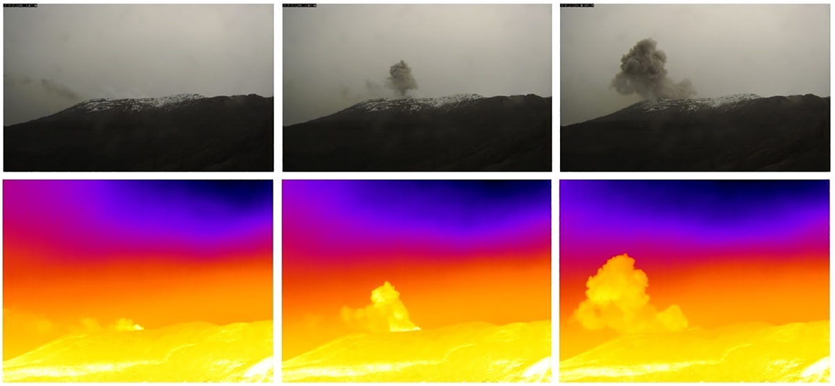 |
Figure 117. Images captured by a traditional camera (top) and a thermal camera (bottom) at Nevado del Ruiz showed a small ash emission in the early morning of 30 July 2020. Ashfall was reported in Manizales. The cameras are located 3.7 km W of the Arenas crater. Courtesy of SGC (Emisión de ceniza Volcan Nevado del Ruiz Julio 30 de 2020). |
Seismicity increased in August 2020 with respect to July. Some of the LP and TR (tremor) seismicity was associated with small emissions of gas and ash, confirmed by web cameras, park personnel, and the Washington VAAC. The Washington VAAC received a report from the Bogota MWO of an ash emission on 1 August that rose to 6.1 km altitude and drifted NW; it was not visible in satellite imagery. Various episodes of short duration drumbeat seismicity were recorded during the month. The tallest steam and gas plume reached 1,800 m above the rim on 31 August. Despite the fact that in August the meteorological conditions made it difficult to monitor the surface activity of the volcano, three ash emissions were confirmed by SGC.
Seismicity decreased during September 2020 with respect to August. Some of the LP and TR (tremor) seismicity was associated with small emissions of gas and ash, confirmed by web cameras, park personnel and the Washington VAAC. The Washington VAAC reported an ash emission on 16 September that rose to 6.1 km altitude and drifted NW. A minor ash emission on 20 September drifted W from the summit at 5.8 km altitude. A possible emission on 23 September drifted NW at 6.1 km altitude for a brief period before dissipating. Two emissions were reported drifting WNW of the summit on 26 September at 5.8 and 5.5 km altitude. Continuous volcanic tremors were registered throughout September, with the higher energy activity during the second half of the month. One episode of drumbeat seismicity on 15 September lasted for 38 minutes and consisted of 25 very low energy earthquakes. Steam and gas plumes reached 1,800 m above the crater rim during 17-28 September (figure 118). Five emissions of ash were confirmed by the webcams and park officials during the month, in spite of difficult meteorological conditions; three of them occurred between 15 and 20 September.
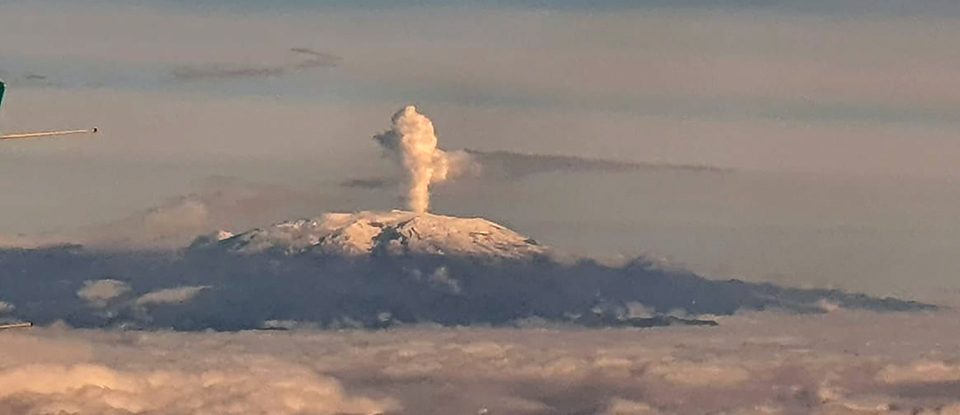 |
Figure 118. A dense plume of steam rose from Nevado del Ruiz in the morning of 17 September 2020. Courtesy of Gonzalo. |
Seismicity increased during October with respect to September. A few of the LP and tremor seismic events were associated with small emissions of gas and ash, confirmed by web cameras, park personnel, and the Washington VAAC. The Washington VAAC issued advisories of possible ash emissions on 2, 6, 9, 11, 15, 17, 18, and 21 October. The plumes rose to 5.6-6.4 km altitude and drifted primarily W and NW. Steam plumes were visible most days of the month (figure 119). Only a few were visible in satellite data, but most were visible in the webcams. Several episodes of drumbeat seismicity were recorded on 13, 22-25, and 27 October, which were characterized by being of short duration and consisting of very low energy earthquakes. The tallest plume during the month rose about 2 km above the crater rim on 18 October. Ash emissions were recorded eight times during the month by SGC.
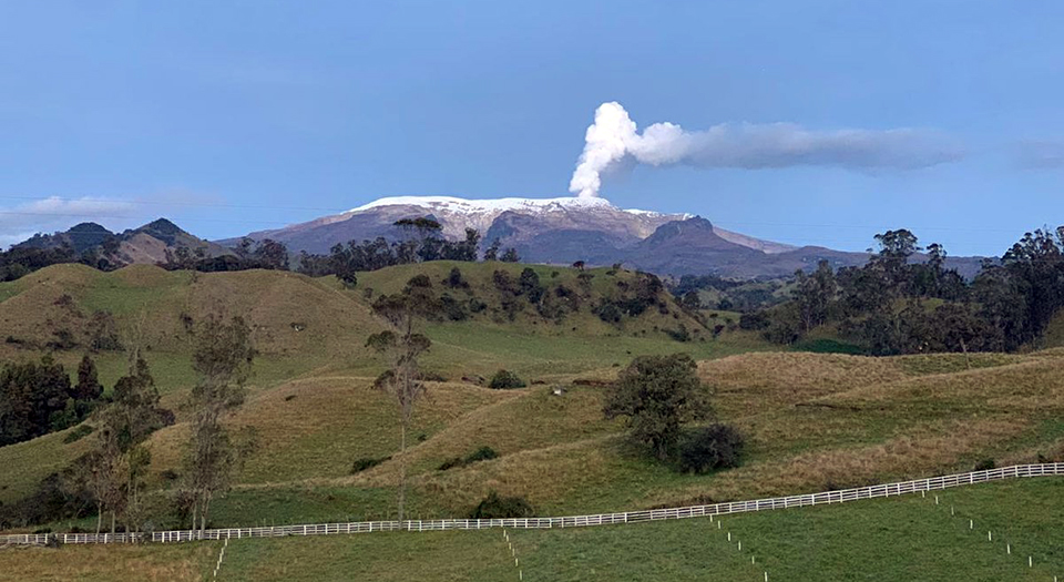 |
Figure 119. A steam plume mixed with possible ash drifted SE from Nevado del Ruiz on 7 October 2020. Courtesy of vlucho666. |
During November 2020, the number of seismic events decreased relative to October, but the amount of energy released increased. Some of the seismicity was associated with small emissions of gas and ash, confirmed by webcams around the volcano. The Washington VAAC reported ash emissions on 22 and 30 November; the 22 November event was faintly visible in satellite images and was also associated with an LP seismic event. They rose to 5.8-6.1 km altitude and drifted W. Various episodes of drumbeat seismicity registered during November were short- to moderate-duration, very low energy, and consisted of seismicity associated with rock fracturing (VT). Multiple steam plumes were visible from communities tens of kilometers away (figure 120).
 |
Figure 120. Multiple dense steam plumes were photographed from communities around Nevado del Ruiz during November 2020, including on 18 (top) and 20 (bottom) November. Top image courtesy of Jose Fdo Cuartas, bottom image courtesy of Efigas Oficial. |
Seismic activity increased in December 2020 relative to November. It was characterized by continuous volcanic tremor, tremor pulses, long-period (LP) and very long-period (VLP) earthquakes. Some of these signals were associated with gas and ash emissions, one confirmed through the webcams. The Washington VAAC reported ash emissions on 5 and 7 December. The first rose to 5.8 km altitude and drifted NW. The second rose to 6.7 km altitude and drifted W. A single discrete cloud was observed 35 km W of the summit; it dissipated within six hours. Drumbeat seismic activity increased as well in December; the episode on 3 December was the most significant. Steam and gas emissions continued throughout the month; a plume of gas and ash reached 1,700 m above the summit on 20 December, and drifted NW.
Sentinel-2 satellite data showed at least one thermal anomaly inside the Arenas crater each month during August-December 2020, corroborating the seismic evidence that the dome continued to grow throughout the period (figure 121). Sulfur dioxide emissions were persistent, with many days every month recording DU values greater than two with the TROPOMI instrument on the Sentinel 5-P satellite (figure 122).
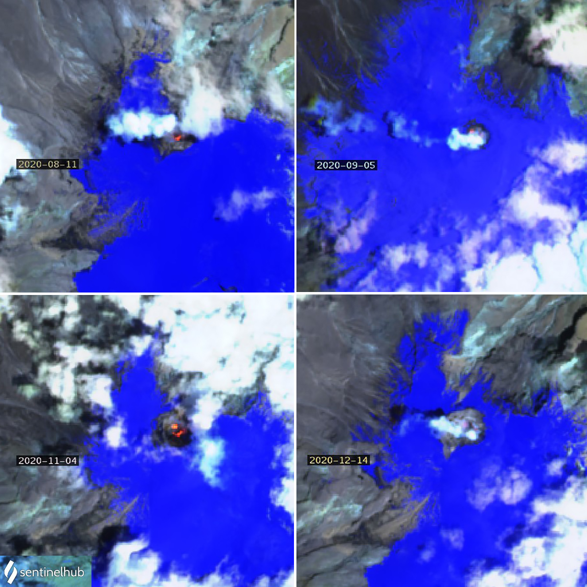 |
Figure 121. Thermal anomalies at Nevado del Ruiz were recorded at least once each month during August-December 2020 suggesting continued growth of the dome within the Arenas crater at the summit. Courtesy of Sentinel Hub Playground. |
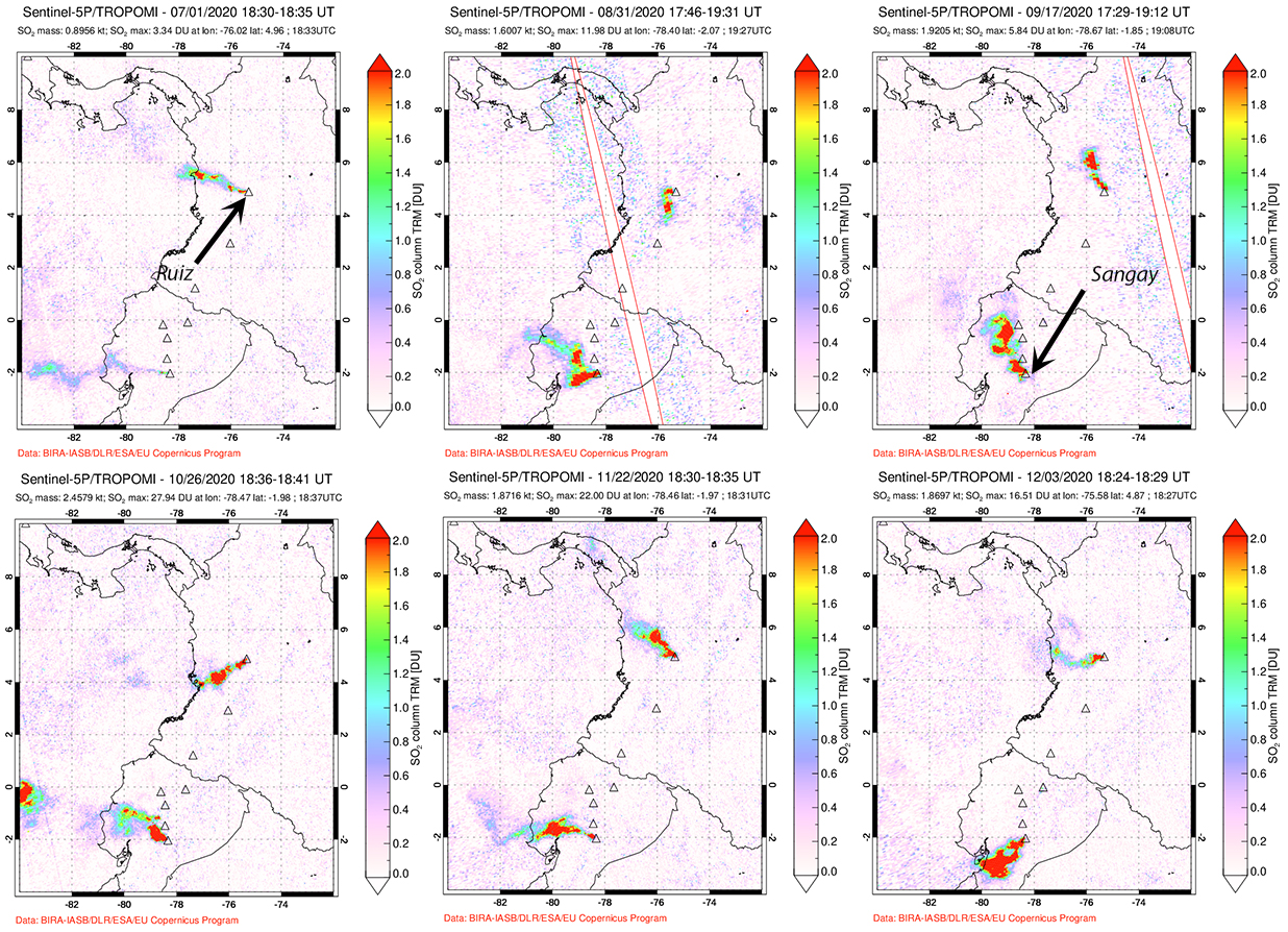 |
Figure 122. Sulfur dioxide emissions were persistent at Nevado del Ruiz during August-December 2020, with many days every month recording DU values greater than two with the TROPOMI instrument on the Sentinel 5-P satellite. Ecuador’s Sangay had even larger SO2 emissions throughout the period. Dates are at the top of each image. Courtesy of NASA Global Sulfur Dioxide Monitoring Page. |
Additional reports of activity during 2017. Activity appears to have continued during June-December 2017. Ash emissions were reported by the Bogota Meteorological Weather Office (MWO) on 13 May, and by SGC on 28 May. During June, some of the recorded seismic events were associated with minor emissions of ash; these were confirmed by webcams and by field reports from both the staff of SGC and the Los Nevados National Natural Park (PNNN). Ash emissions were confirmed in webcams by park officials on 3, 16, and 17 June. Gas emissions from the Arenas crater during July 2017 averaged 426 m above the crater rim, generally lower than during June. The emissions were mostly steam with small amounts of SO2. Emissions were similar during August, with most steam and gas plumes drifting NW. No ash emissions were reported during July or August.
SGC reported steam and gas plumes during September that rose as high as 1,650 m above the crater rim and drifted NW. On 21 September the Washington VAAC received a report of an ash plume that rose to 6.4 km altitude and drifted NNW, although it was not visible in satellite imagery. Another ash emission rising to 6.7 km altitude was reported on 7 October; weather clouds prevented satellite observation. An episode of drumbeat seismicity was recorded on 9 October, the first since April 2017. While SGC did not explicitly mention ash emissions during October, several of the webcam images included in their report show plumes described as containing ash and gas (figure 123).
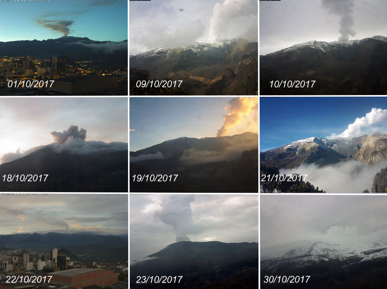 |
Figure 123. Plumes of steam, gas, and ash rose from Arenas crater at Nevado del Ruiz most days during October 2017. Photographs were captured by the webcams installed in the Azufrado Canyon and Cerro Gualí areas. Courtesy of SGC (INFORME DE ACTIVIDAD VOLCANICA SEGMENTO NORTE DE COLOMBIA, OCTUBRE DE 2017). |
The Washington VAAC received a report from the Bogota MWO of an ash emission that rose to 6.1 km altitude and drifted NE on 8 November 2017. A faint plume was visible in satellite imagery extending 15 km NE from the summit. SGC reported that plumes rose as high as 2,150 m above the rim of Arenas crater during November. The plumes were mostly steam, with minor amounts of SO2. A diffuse plume of ash was photographed in a webcam on 24 November. SGC did not report any ash emissions during December 2017, but the Washington VAAC reported “a thin veil of volcanic ash and gases” visible in satellite imagery and webcams on 18 December that dissipated within a few hours. In addition to the multiple reports of ash emissions between May and December 2017, Sentinel-2 thermal satellite imagery recorded at least one image each month during June-December showing a thermal anomaly at the summit consistent with the slowly growing dome first reported in August 2015 (figure 124).
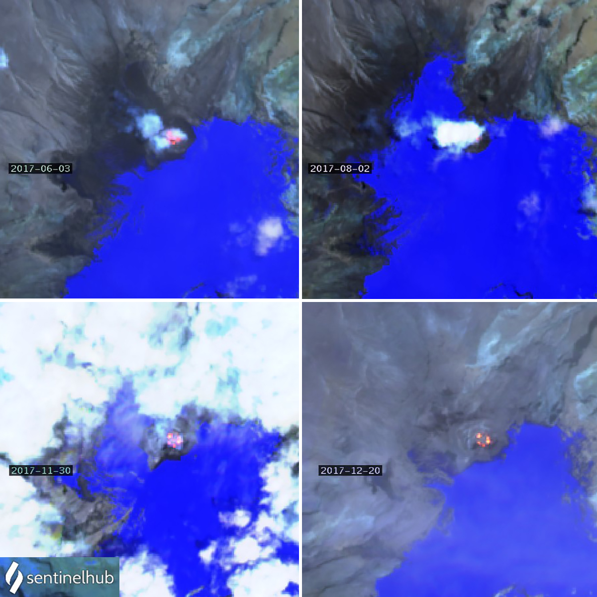 |
Figure 124. Thermal anomalies from the growing dome inside Arenas crater at the summit of Nevado del Ruiz appeared at least once each month from June-December 2017. A strong anomaly was slightly obscured by clouds on 3 June (top left). On 2 August, a steam plume obscured most of the crater, but a small thermal anomaly is visible in its SE quadrant (top right). Strong anomalies on 30 November and 20 December (bottom) have a ring-like form suggestive of a growing dome. Atmospheric penetration rendering (bands 12, 11, 8A), courtesy of Sentinel Hub Playground. |
Geological Summary. Nevado del Ruiz is a broad, glacier-covered volcano in central Colombia that covers more than 200 km2. Three major edifices, composed of andesitic and dacitic lavas and andesitic pyroclastics, have been constructed since the beginning of the Pleistocene. The modern cone consists of a broad cluster of lava domes built within the caldera of an older edifice. The 1-km-wide, 240-m-deep Arenas crater occupies the summit. The prominent La Olleta pyroclastic cone located on the SW flank may also have been active in historical time. Steep headwalls of massive landslides cut the flanks. Melting of its summit icecap during historical eruptions, which date back to the 16th century, has resulted in devastating lahars, including one in 1985 that was South America's deadliest eruption.
Information Contacts: MIROVA (Middle InfraRed Observation of Volcanic Activity), a collaborative project between the Universities of Turin and Florence (Italy) supported by the Centre for Volcanic Risk of the Italian Civil Protection Department (URL: http://www.mirovaweb.it/); Sentinel Hub Playground (URL: https://www.sentinel-hub.com/explore/sentinel-playground); Global Sulfur Dioxide Monitoring Page, Atmospheric Chemistry and Dynamics Laboratory, NASA Goddard Space Flight Center (NASA/GSFC), 8800 Greenbelt Road, Goddard, Maryland, USA (URL: https://so2.gsfc.nasa.gov/); Gonzalo (URL: https://twitter.com/chaloc22/status/1306581929651843076); Jose Fdo Cuartas (URL: https://twitter.com/JoseFCuartas/status/1329212975434096640); Vlucho666 (URL: https://twitter.com/vlucho666/status/1313791959954268161); Efigas Oficial (URL: https://twitter.com/efigas_oficial/status/1329780287920873472).