Report on Pelee (France) — July 2021
Bulletin of the Global Volcanism Network, vol. 46, no. 7 (July 2021)
Managing Editor: Edward Venzke.
Edited by Kadie L. Bennis.
Pelee (France) Elevated seismicity since December 2020; vegetation damaged by carbon dioxide degassing
Please cite this report as:
Global Volcanism Program, 2021. Report on Pelee (France) (Bennis, K.L., and Venzke, E., eds.). Bulletin of the Global Volcanism Network, 46:7. Smithsonian Institution. https://doi.org/10.5479/si.GVP.BGVN202107-360120
Pelee
France
14.809°N, 61.166°W; summit elev. 1372 m
All times are local (unless otherwise noted)
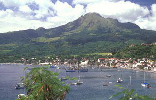
Mount Pelée is a stratovolcano that forms the north end of the French island of Martinique, along the Lesser Antilles subduction zone. There have been at least four eruptions over the past 250 years: phreatic eruptions in 1792 and 1851, and more recently, magmatic eruptions that built lava domes during 1902-1905 and 1929-1932. Fumaroles at the summit in the area of those lava domes were active until 1970, but not since then. There are thermal springs on the upper and lower flanks of the volcano, most notably at the Rivière Chaude, Rivière Claire, Rivière Picodo and Rivière Mitan, as well as a few hydrothermal submarine springs on the Caribbean Sea coast to the southwest (figure 1). Information for this report was provided by the Volcanological and Seismological Observatory of Martinique (OVSM), Institut de Physique du Globe de Paris (IPGP), with contributions from F.R. Fontaine (IPGP, OVSM), J-C. Komorowski (IPGP), J. Corbeau (IPGP, OVSM), A. Burtin (IPGP), F. Jadelus (IPGP, OVSM), D. Melezan (IPGP, OVSM), C. Vidal (IPGP, OVSM), B. Zimmermann (IPGP, OVSM), J.M. Lavenaire (IPGP, OVSM), J.-G. Gabriel (IPGP, OVSM), J.-M. Saurel (IPGP), A. Lemarchand (IPGP), R. Grandin (IPGP), J.-B. de Chabalier (IPGP), F. Beauducel (IPGP), S. Moune (IPGP, OVSG), E. Chilun-Eusebe (IPGP, OVSG), V. Robert, R. Moretti (IPGP, OVSG), G. Boudon (IPGP), G. Carazzo (IPGP), A. Michaud-Dubuy (IPGP), and S. Tait (OMP).
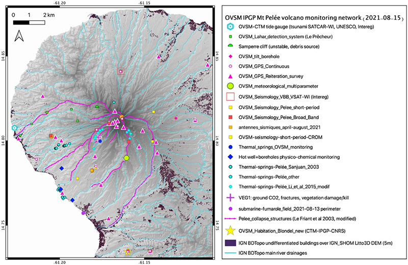 |
Figure 1. Map of Mount Pelée showing the monitoring networks in Martinique. Courtesy of OVSM – IPGP. |
Seismicity since 1980 and the installation of monitoring networks (figures 1 and 2) has typically been low. A few volcano-tectonic (VT) earthquakes were observed between 1 January 2015 and 1 April 2019, with a mean of two and a standard deviation of six earthquakes per month. Increased volcanic seismicity was recorded starting in April 2019 located 4-5 km below the summit (figure 3). A stronger increase was recorded between 2-15 December 2020 with 316 VT earthquakes during this period.
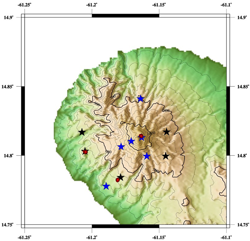 |
Figure 2. The seismic network of the OVSM - IPGP used for monitoring Mount Pelée. Broad-band three component seismic stations are in blue, short-period one component seismometers are in black, and temporary seismic nodes are in red. Courtesy of IPGP. |
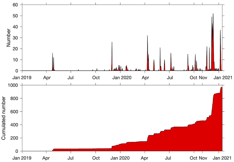 |
Figure 3. Graphs showing the daily number of volcano-tectonic (VT) earthquakes (top) recorded and the cumulated number of VT earthquakes (bottom) from 1 January 2019 to 14 January 2021 at Mount Pelée. The VT earthquakes were derived from the manual catalog of OVSM – IPGP. Courtesy of IPGP. |
In addition to the shallow VT events, a few deep VT earthquakes (~15 km below sea level) were recorded below the volcano in April-May 2019 (5) and November 2019 (1); this type of seismicity was not observed between January 2014 and March 2019. New tremor-type signals were recorded on 8 and 9 November 2020 (figure 4). Eight long-period (LP) earthquakes were detected in December 2020 during the stronger increase in volcanic seismic activity. Seismic activity typically occurred in swarms lasting up to a few days and has fluctuated since 4 December 2020, but remained significantly higher than base level (table 1 and figure 5). Despite the ongoing unrest, the seismic energy released has remained low and no volcanic earthquakes have been felt.
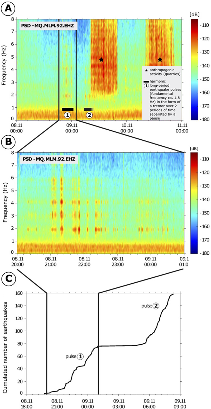 |
Figure 4. Spectrograms (a and b) of volcanic tremor at Mount Pelée recorded by a seismic station (MLM) of the OVSM - IPGP from 8-9 November 2020. (c) Cumulated number of long-period events detected within the volcanic tremor signal. Courtesy of IPGP. |
Table 1. Monthly numbers of volcanic earthquakes recorded at Mount Pelée by the OVSM – IPGP during December 2020-June 2021. Courtesy of IPGP.
| Month | Volcano-tectonic | Long-period | Hybrid | Tremor |
| Dec 2020 | 342 | 8 | 3 | 3 |
| Jan 2021 | 162 | 5 | 2 | 3 |
| Feb 2021 | 109 | 1 | 1 | 2 |
| Mar 2021 | 120 | 0 | 0 | 1 |
| Apr 2021 | 533 | 0 | 13 | 0 |
| May 2021 | 199 | 0 | 0 | 0 |
| Jun 2021 | 97 | 0 | 1 | 0 |
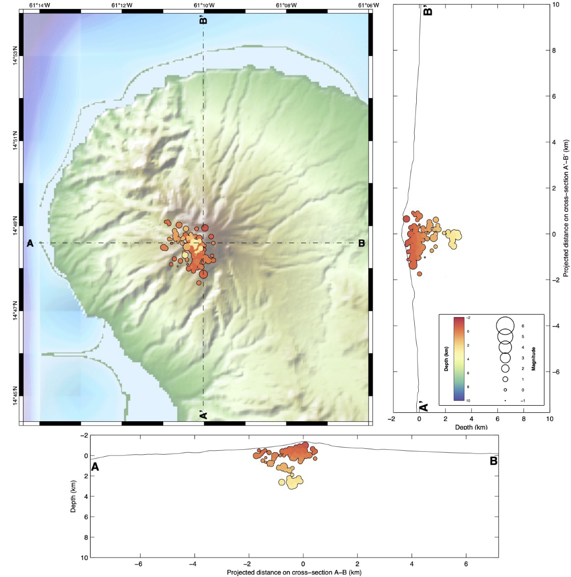 |
Figure 5. Map of Mount Pelée with N-S (right) and E-W (bottom) cross-sections showing the position and depth of hypocenters of the seismic events in April 2021. Only earthquakes that could be located are shown. Courtesy of IPGP. |
Due to the increased seismicity, OVSM - IPGP raised the Volcanic Alert Level (VAL) to Yellow (the second level on a four-color scale) on 4 December 2020. A zone of damaged, browned, and dead vegetation was observed at the end of December 2020 on the southwest flank between the upper Rivière Claire and the Rivière Chaude, above their confluence. A field expedition on 8 February 2021 by OVSM - IPGP investigators, with the support of the Emergency and Fire Department (STIS) and the civil protection helicopter, confirmed that the vegetation damage was associated with elevated levels of diffuse passive soil degassing of carbon dioxide from the ground. There were no visible fumaroles. This area is less than 200 m from the Rivière Claire where the presence of hydrogen sulfide has been reported in scientific literature for several years, in the vicinity of thermal springs.
Ground fractures in the center of the most deteriorated vegetation zone were 20-60 cm wide, 2-3 m deep, and several tens of meters long. Although some fractures had formed in the past, the clearest ones linked to the damaged vegetation may have formed recently. No fumarolic, water vapor, or gas emissions were visible and there was no thermal anomaly associated with these fractures. There was no evidence of significant fluid movements at depth recorded by the deformation network, or any changes in temperature or pH of the water at the regularly monitored sites. These observations are interpreted as reflecting increased activity of the hydrothermal system.
Geological Summary. Montagne Pelée forms the northern end of the island of Martinique. Three major edifice failures since the late Pleistocene, the last about 9,000 years ago, have left large scarps open to the SW inside which the modern volcano has been constructed. More than 20 large eruptions have occurred here during the past 5,000 years. Extensive pyroclastic-flow deposits, incised by steep-walled ravines, mantle the slopes of the volcano. The l'Etang Sec summit crater is filled by two lava domes emplaced during the 1902 and 1929 eruptions. Moderate phreatic or phreatomagmatic eruptions in the Upper Rivière Claire valley were recorded in 1792 and 1851-52. The catastrophic 1902 eruption, which destroyed the city of St. Pierre, became the type-example of Pelean eruptions and marked the onset of modern volcanological studies of pyroclastic density currents.
Information Contacts: Université de Paris, Institut de Physique du Globe de Paris (IPGP), CNRS, F-75005 Paris, France (URL: http://www.ipgp.fr/); Observatoire Volcanologique et Sismologique de la Martinique (OVSM), Institut de Physique du Globe de Paris, 97250, Fonds Saint Denis, France (URL: http://www.ipgp.fr/fr/ovsm/actualites-communiques-publics-de-lovsm, https://doi.org/10.18715/MARTINIQUE.OVSM, real-time location of seismic events are available at ws.ipgp.fr/fdsnws/event/1/ and https://renass.unistra.fr/fr/zones/les-antilles/); Observatoire Volcanologique et Sismologique de la Guadeloupe (OVSG), Institut de Physique du Globe de Paris, 97113, Gourbeyre, France (URL: https://www.ipgp.fr/fr/ovsg/observatoire-volcanologique-sismologique-de-guadeloupe); Observatoire Midi-Pyrénées (OMP), 31400 Toulouse, France (URL: https://www.omp.eu/).