Report on Turrialba (Costa Rica) — September 2021

Bulletin of the Global Volcanism Network, vol. 46, no. 9 (September 2021)
Managing Editor: Edward Venzke.
Research and preparation by Paul Berger.
Turrialba (Costa Rica) Small phreatic explosions in June and July 2021
Please cite this report as:
Global Volcanism Program, 2021. Report on Turrialba (Costa Rica) (Venzke, E., ed.). Bulletin of the Global Volcanism Network, 46:9. Smithsonian Institution. https://doi.org/10.5479/si.GVP.BGVN202109-345070
Turrialba
Costa Rica
10.025°N, 83.767°W; summit elev. 3340 m
All times are local (unless otherwise noted)
Volcanism at Turrialba increased after September 2014 with cycles of ash explosions, numerous weak and passive ash plumes, and emissions that continued into 2019; thereafter activity progressively diminished until weak explosions and ash emissions took place between mid-June and 24 August 2020 (BGVN 43:09, 44:04, 44:11, 45:09). The following report summarizes activity from September 2020 through August 2021 and is based primarily on information from weekly reports published by the Observatorio Vulcanologico Sismologica de Costa Rica-Universidad Nacional (OVSICORI-UNA) and satellite data.
Based on OVSICORI-UNA’s annual report, cooling allowed the reappearance of a hydrothermal system, as indicated by the presence of H2S in the gas plume. Landslides along the rim filled in the crater by 50 m, raising the floor from 180 m depth in 2017 to only 130 m deep by the end of 2020. The crater’s diameter also increased, particularly in the S. Seismicity during this period was generally low, with some fluctuations attributed to changes in the hydrothermal system due to infiltration by rainwater. White emissions were observed throughout the reporting period in Sentinel-2 satellite images and OVSICORI-UNA webcam images (figure 54).
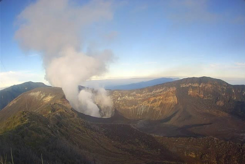 |
Figure 54. Webcam image of a typical white degassing plume with no ash at Turrialba, seen here on 23 March 2021. Courtesy of OVSICORI-UNA. |
OVSICORI-UNA reported a weak 2-minute phreatic explosion at 1800 on 13 June that ejected a small amount of non-juvenile ash to 300 m above the crater and drifted SW. Trace ashfall (less than 1 mm accumulation) was reported in Monte Calas (2 km SSE) and in La Central (2 km SW). Strong gas odors were reported in La Pastora (6 km SSW) in the early morning, and rumbles were heard from various places around the volcano. The explosion was not associated with changes in seismicity, deformation, or gas chemistry, but may have been related to rainfall. Observation with infrared cameras showed a decrease in area of the fumarolic zone within the active crater between November 2020 and 16 June 2021, as well as the presence of some very active fumaroles. Fieldwork by OVSICORI-UNA in mid-March found a fumarole temperature at 440°C on the inner NW wall of the active crater.
According to OVSICORI-UNA, a one-minute explosion was recorded at 1130 on 23 July 2021, though weather clouds prevented visual confirmation of a plume; ash fell in areas 3.5 km W. Heavy rainfall in the area on 22 July had caused major flooding in a nearby town of Turrialba (SW of the volcano) and may have triggered the explosion. By 24 July lakes had formed in and near the central crater (figure 55). Seismicity did not change, and geodesic measurements confirmed that slight contraction continued.
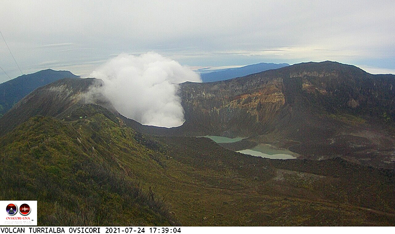 |
Figure 55. Image of Turrialba on 24 July 2021 showing that a lake(s) has formed in the central crater and between craters as a result of heavy rainfall. Courtesy of OVSICORI-UNA. |
Meteorological clouds usually obscured Sentinel-2 satellite observations. However, there was a weak but persistent thermal signal throughout September 2020-August 2021, along with the weak white emissions. TROPOMI data from the Sentinel-5P satellite did not show significant SO2 levels near the Irazú-Turrialba massif during September 2020-January 2021. However, some SO2 emissions were recorded thereafter, most prominently on 15 March, 23 March (figure 56), and 24 April 2021. None were recorded during the 13 June or 23 July explosions.
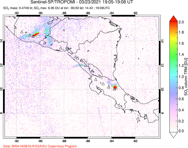 |
Figure 56. Sulfur dioxide emission drifting N from the Irazú-Turrialba massif on 23 March 2021 (lower right), as recorded by the TROPOMI instrument aboard the Sentinel-5P satellite. Courtesy of NASA Global Sulfur Dioxide Monitoring Page. |
Geological Summary. Turrialba, the easternmost of Costa Rica's Holocene volcanoes, is a large vegetated basaltic-to-dacitic stratovolcano located across a broad saddle NE of Irazú volcano overlooking the city of Cartago. The massive edifice covers an area of 500 km2. Three well-defined craters occur at the upper SW end of a broad 800 x 2200 m summit depression that is breached to the NE. Most activity originated from the summit vent complex, but two pyroclastic cones are located on the SW flank. Five major explosive eruptions have occurred during the past 3500 years. A series of explosive eruptions during the 19th century were sometimes accompanied by pyroclastic flows. Fumarolic activity continues at the central and SW summit craters.
Information Contacts: Observatorio Vulcanologico Sismologica de Costa Rica-Universidad Nacional (OVSICORI-UNA), Apartado 86-3000, Heredia, Costa Rica (URL: http://www.ovsicori.una.ac.cr/, https://www.facebook.com/OVSICORI/); Sentinel Hub Playground (URL: https://www.sentinel-hub.com/explore/sentinel-playground); NASA Global Sulfur Dioxide Monitoring Page, Atmospheric Chemistry and Dynamics Laboratory, NASA Goddard Space Flight Center (NASA/GSFC), 8800 Greenbelt Road, Goddard MD, USA (URL: https://so2.gsfc.nasa.gov/).