Report on Barren Island (India) — December 2021

Bulletin of the Global Volcanism Network, vol. 46, no. 12 (December 2021)
Managing Editor: Edward Venzke.
Edited by Kadie L. Bennis.
Barren Island (India) Thermal anomalies and ash emissions persist during March-August 2021
Please cite this report as:
Global Volcanism Program, 2021. Report on Barren Island (India) (Bennis, K.L., and Venzke, E., eds.). Bulletin of the Global Volcanism Network, 46:12. Smithsonian Institution. https://doi.org/10.5479/si.GVP.BGVN202112-260010
Barren Island
India
12.278°N, 93.858°E; summit elev. 354 m
All times are local (unless otherwise noted)
Barren Island is a remote island east of India in the Andaman Islands. Numerous eruptions were reported during 1787-1832, and then more starting in 1991, consisting of ash plumes, Strombolian explosions, and lava flows. The current eruption began in 2018, and typical activity includes ash emissions and thermal anomalies (BGVN 46:03). This report describes similar thermal activity and ash plumes during March through August 2021 using various satellite data as a primary source of information. During 23 August through November 2021 a total of three thermal anomalies were detected on 13-14 and 19 October in Suomi NPP/VIIRS sensor data.
Activity during this reporting period was relatively low, characterized primarily by thermal anomalies. The MIROVA thermal anomaly data from March through August 2021 showed intermittent low- to moderate-levels of thermal activity; during mid-May a single cluster of several anomalies was detected (figure 52). Between July and August, the number of anomalies declined to a total of five. The cluster of activity was also reflected in Suomi NPP/VIIRS sensor data over 18 days on 2, 4, 12, 14, 19, 26 March, 9 and 19 April, 2, 6, 8, 10, 13, 31 May, 3 and 13 June, 26 July, and 21 August. Gray ash emissions were visible rising above the volcano on 15 May and 14 July in Natural Color Sentinel-2 satellite images (figure 53). Eight thermal anomalies were detected in the summit crater on clear weather days in Sentinel-2 infrared satellite images on 1 and 6 March, 25 April, 5 and 15 May, 4 June, 29 July, and 23 August (figure 54).
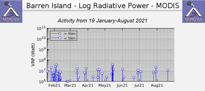 |
Figure 52. The MIROVA thermal anomaly data (Log Radiative Power) from March through August 2021 showed low- to moderate- levels of thermal activity. A single cluster of several anomalies was detected in mid-May. Courtesy of MIROVA. |
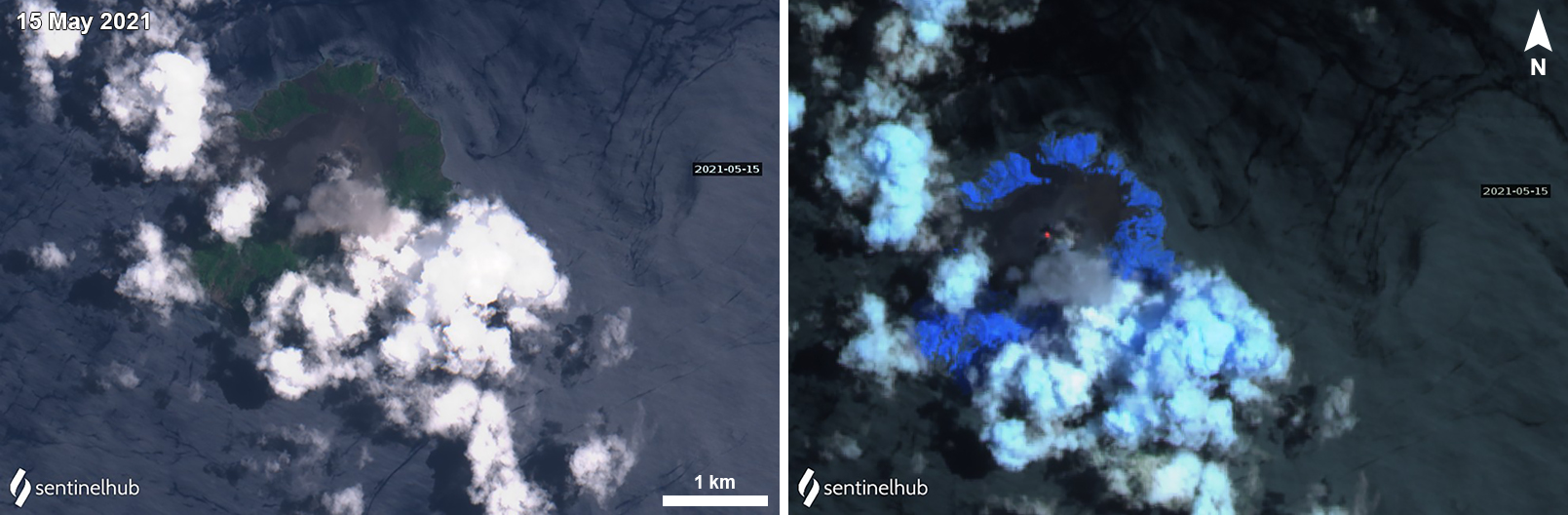 |
Figure 53. A discrete ash emission and a thermal anomaly at the summit of Barren Island were detected in Sentinel-2 satellite imagery on 15 May 2021. Left image uses “Natural Color” rendering (bands 4, 3, 2) and right image uses “Atmospheric penetration” rendering (bands 12, 11, 8a). Courtesy of Sentinel Hub Playground. |
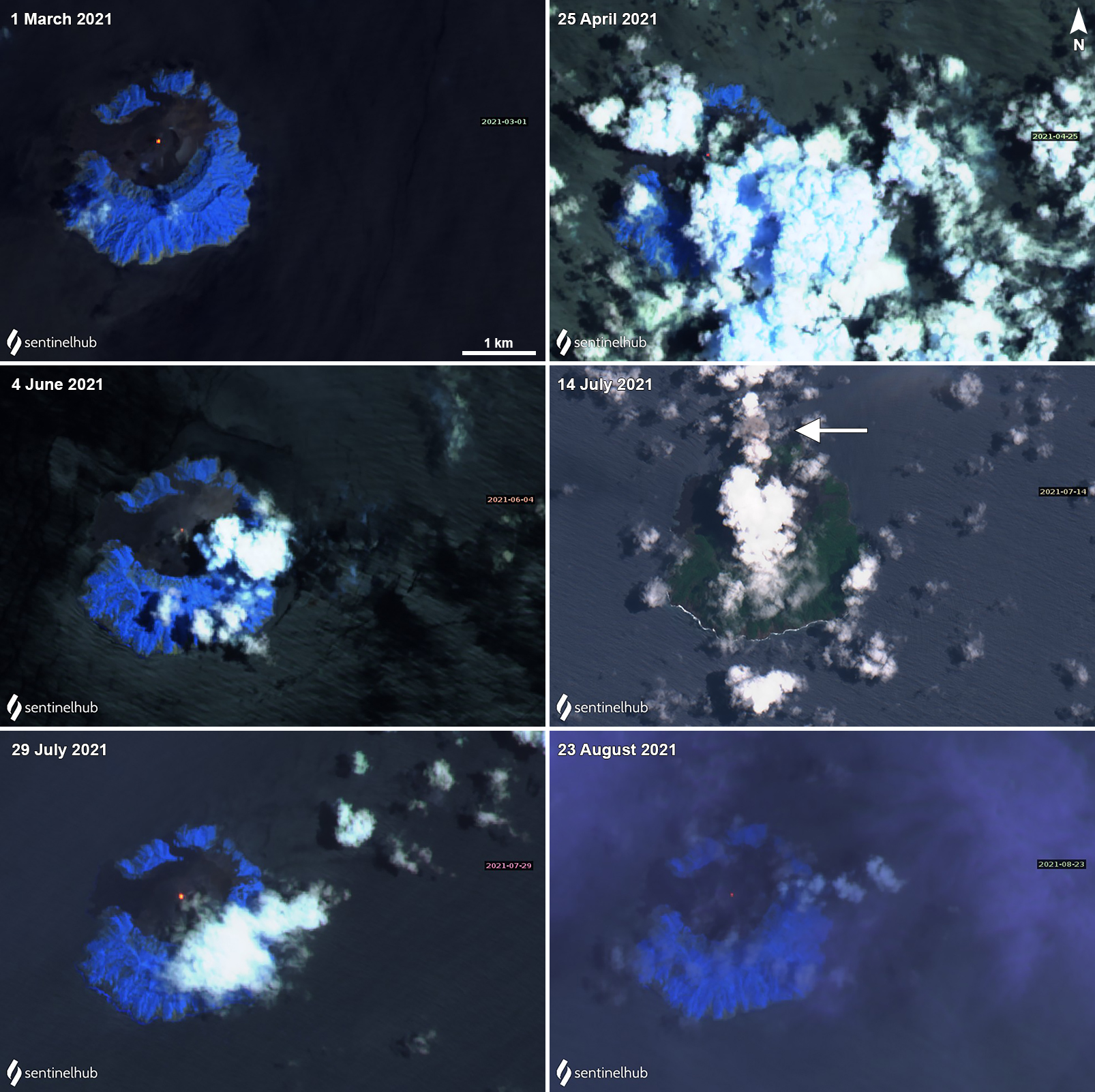 |
Figure 54. A small thermal anomaly persisted in the summit crater at Barren Island, which decreased in power over time, was detected in Sentinel-2 infrared satellite imagery on 1 March (top left), 25 April (top right), 4 June (middle left), 29 July (bottom left), and 23 August (bottom right) 2021. On 14 July (middle right) a small ash emission was visible drifting N of the volcano (white arrow). Images using “Atmospheric penetration” rendering (bands 12, 11, 8a) except for 14 July which uses “Natural Color” rendering (bands 4, 3, 2). Courtesy of Sentinel Hub Playground. |
Geological Summary. Barren Island, a possession of India in the Andaman Sea about 135 km NE of Port Blair in the Andaman Islands, is the only historically active volcano along the N-S volcanic arc extending between Sumatra and Burma (Myanmar). It is the emergent summit of a volcano that rises from a depth of about 2250 m. The small, uninhabited 3-km-wide island contains a roughly 2-km-wide caldera with walls 250-350 m high. The caldera, which is open to the sea on the west, was created during a major explosive eruption in the late Pleistocene that produced pyroclastic-flow and -surge deposits. Historical eruptions have changed the morphology of the pyroclastic cone in the center of the caldera, and lava flows that fill much of the caldera floor have reached the sea along the western coast.
Information Contacts: MIROVA (Middle InfraRed Observation of Volcanic Activity), a collaborative project between the Universities of Turin and Florence (Italy) supported by the Centre for Volcanic Risk of the Italian Civil Protection Department (URL: http://www.mirovaweb.it/); Sentinel Hub Playground (URL: https://www.sentinel-hub.com/explore/sentinel-playground); NASA Worldview (URL: https://worldview.earthdata.nasa.gov/).