Report on Ebeko (Russia) — December 2021
Bulletin of the Global Volcanism Network, vol. 46, no. 12 (December 2021)
Managing Editor: Edward Venzke.
Edited by Kadie L. Bennis.
Ebeko (Russia) Intermittent explosions, ash plumes, and ashfall during June-November 2021
Please cite this report as:
Global Volcanism Program, 2021. Report on Ebeko (Russia) (Bennis, K.L., and Venzke, E., eds.). Bulletin of the Global Volcanism Network, 46:12. Smithsonian Institution. https://doi.org/10.5479/si.GVP.BGVN202112-290380
Ebeko
Russia
50.686°N, 156.014°E; summit elev. 1103 m
All times are local (unless otherwise noted)
Ebeko occupies the N end of Paramushir Island in the Kuril Islands, consisting of three summit craters. Recorded eruptions since the late 18th century have been restricted to small-to-moderate explosions from the summit craters, as well as intense fumarolic activity. The current eruption period began during October 2016 and more recently has been characterized by frequent explosions, ash plumes, and ashfall (BGVN 46:06). This report covers activity during June through November 2021, describing similar activity of explosions, ash plumes, and ashfall, based on information from the Kamchatka Volcanic Eruptions Response Team (KVERT), the Tokyo Volcanic Ash Advisory Center (VAAC), and satellite data.
Frequent explosions were reported by volcanologists in Severo-Kurilsk (7 km E) during June and generated ash plumes that rose as high as 1.5-4.5 km altitude and drifted in different directions. A thermal anomaly was detected in satellite images on 2 and 10 June. An ash plume on 4 June rose to 3-3.4 km altitude and drifted SE, based on information from a Tokyo VAAC notice. Another ash plume on 6 June rose to 3.7 km altitude and extended NE. Volcanologists from Severo-Kurilsk reported an explosion that ejected ash to 4 km altitude that drifted 5 km NE on 11 June. The next day, on 12 June an explosion produced an ash plume that rose to 2-3 km altitude and drifted 6 km NE. On 22 June an ash plume rose to 2.2 km altitude and drifted 3 km SE.
Similar activity continued into July, with ash rising to 1.8-4.5 km altitude and drifting in multiple directions. A thermal anomaly was detected in satellite imagery during 5-7, 10, 12, 16, 20-22, and 25 July. An explosion on 4 July produced an ash plume that rose to 3.7 km altitude and drifted S (figure 36). On 10 July an explosion generated an ash plume that rose to 3 km altitude and drifted 5 km E. Explosions during 12-13 July produced ash plumes that rose to 2.5-3 km altitude and extended 3-5 km E and SE. On 29 July an explosion generated an ash plume that rose to 2 km altitude and drifted as far as 10 km S.
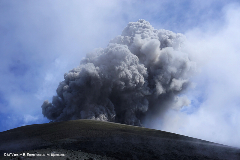 |
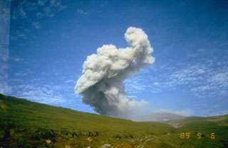
Figure 36. Photo of an explosion at Ebeko on 4 July 2021, accompanied by a strong ash plume. Photo by M. Shchekleina, M.V. Lomonosov MGU, courtesy of IVS FEB RAS, KVERT. |
Explosions persisted in August and the resulting ash plumes rose to 1.8-4.6 km altitude and drifted in different directions. On 7 August an explosion rose to 2 km altitude and drifted 3 km SE. An explosion on 25 August produced an ash plume that rose to 3.7 km altitude and drifted 10 km SE. A thermal anomaly was reported in satellite images on 1, 6, 9, 11, 13-14, 20, and 23-25 August. On 25 August an explosion generated an ash plume that rose to 3.7 km altitude and drifted 10 km SE (figure 37).
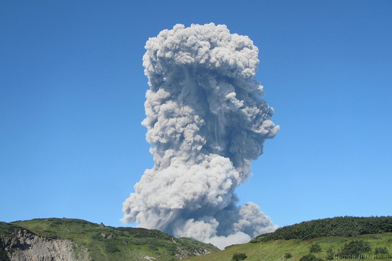 |
Figure 37. Photo of the explosion at Ebeko on 25 August 2021, which produced an ash plume that rose to 3.7 km altitude and drifted 10 km SE. Photo by D. Sytnik, courtesy of IVS FEB RAS, KVERT. |
Explosions in September produced ash plumes that rose to 1.3-2.5 km altitude and drifted in different directions. On 6 and 8 September ashfall was reported in Severo-Kurilsk. During the latter half of September, moderate gas-and-steam plumes were observed, which persisted into October. According to a KVERT weekly report, an explosion on 10 October produced an ash plume that rose to 2.5 km altitude and drifted NE. However, the plume could not be confirmed in satellite or webcam images. On 22 October KVERT lowered the Aviation Color Code (ACC) to Yellow (the second lowest level on a four-color scale), noting that the last visible thermal anomaly over the volcano occurred on 25 August.
A strong explosion was reported at 2340 on 25 October, based on HIMAWARI-8 satellite data. The explosion sent an ash plume up to 6.2 km altitude, which extended for 230 km to the E and later drifted to the SE. In addition, a thermal anomaly was noted over the volcano. Notable ashfall was reported at Severo-Kurilsk. Another explosion on 31 October generated an ash plume that rose to 1.8 km altitude and drifted 5 km NE.
During November, with ash plumes rising to 1.4-2.6 km altitude, in addition to moderate gas-and-steam plumes. On 2 November an ash plume rose to 2.6 km altitude and drifted SE. Explosions were also detected each day during 5-9 November, with ash plumes rising as high as 2.3 km altitude and drifting SE and E. On 7 November volcanologists from Severo-Kurilsk reported an explosion sending ash up to 2.2 km altitude that drifted 5 km NE. On 26 November KVERT lowered the Aviation Color Code (ACC) to Yellow (the second lowest on a four-color scale), noting that although gas-and-steam plumes persisted, the last recorded eruptive activity occurred on 9 November.
According to MIROVA (Middle InfraRed Observation of Volcanic Activity) data, four thermal pixels were detected between June and August 2021 (figure 38). During this time, Sentinel-2 natural color satellite images showed ash plumes and ashfall (dark gray) on the flanks resulting from frequent explosions at the summit (figure 39).
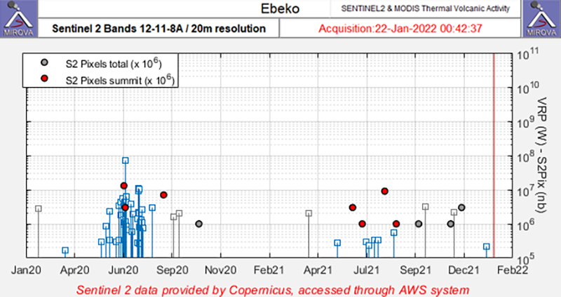 |
Figure 38. Four thermal anomalies were detected at Ebeko (red dots) during June through August 2021 as recorded by the Sentinel-2 MODIS Thermal Volcanic Activity data (bands 12, 11, 8A). Courtesy of MIROVA. |
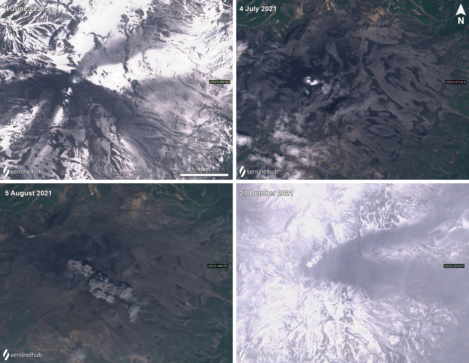 |
Figure 39. Sentinel-2 satellite imagery of ash plumes and ash deposits from Ebeko on 4 June (top left), 4 July (top right), 5 August (bottom left), and 27 October (bottom right) 2021. Ashfall (dark gray) is visible on the flanks in each of these images. Ash plumes drifted NE on 4 June and 27 October, and SE on 5 August. Images using “Natural Color” rendering (bands 4, 3, 2). Courtesy of Sentinel Hub Playground. |
Geological Summary. The flat-topped summit of the central cone of Ebeko volcano, one of the most active in the Kuril Islands, occupies the northern end of Paramushir Island. Three summit craters located along a SSW-NNE line form Ebeko volcano proper, at the northern end of a complex of five volcanic cones. Blocky lava flows extend west from Ebeko and SE from the neighboring Nezametnyi cone. The eastern part of the southern crater contains strong solfataras and a large boiling spring. The central crater is filled by a lake about 20 m deep whose shores are lined with steaming solfataras; the northern crater lies across a narrow, low barrier from the central crater and contains a small, cold crescentic lake. Historical activity, recorded since the late-18th century, has been restricted to small-to-moderate explosive eruptions from the summit craters. Intense fumarolic activity occurs in the summit craters, on the outer flanks of the cone, and in lateral explosion craters.
Information Contacts: Kamchatka Volcanic Eruptions Response Team (KVERT), Far Eastern Branch, Russian Academy of Sciences, 9 Piip Blvd., Petropavlovsk-Kamchatsky, 683006, Russia (URL: http://www.kscnet.ru/ivs/kvert/); Tokyo Volcanic Ash Advisory Center (VAAC), 1-3-4 Otemachi, Chiyoda-ku, Tokyo 100-8122, Japan (URL: http://ds.data.jma.go.jp/svd/vaac/data/); MIROVA (Middle InfraRed Observation of Volcanic Activity), a collaborative project between the Universities of Turin and Florence (Italy) supported by the Centre for Volcanic Risk of the Italian Civil Protection Department (URL: http://www.mirovaweb.it/); Sentinel Hub Playground (URL: https://www.sentinel-hub.com/explore/sentinel-playground).