Report on Nevado del Ruiz (Colombia) — August 2022

Bulletin of the Global Volcanism Network, vol. 47, no. 8 (August 2022)
Managing Editor: Benjamin Andrews.
Edited by Kadie L. Bennis.
Nevado del Ruiz (Colombia) Intermittent ash emissions, thermal activity, and dome growth during January-July 2022
Please cite this report as:
Global Volcanism Program, 2022. Report on Nevado del Ruiz (Colombia) (Bennis, K.L., and Andrews, B., eds.). Bulletin of the Global Volcanism Network, 47:8. Smithsonian Institution.
Nevado del Ruiz
Colombia
4.892°N, 75.324°W; summit elev. 5279 m
All times are local (unless otherwise noted)
Nevado del Ruiz is a broad, glacier-covered volcano in central Colombia, covering more than 200 km2. It contains the 1-km-wide, 240-m-deep Arenas crater that occupies the summit. Eruptions are dated to 8,600 years before present, including observed activity since 1570. This current eruption period has been ongoing since November 2014 and has more recently consisted of continued dome growth, ash emissions, ashfall, and seismicity. This report covers intermittent ash emissions, ashfall, thermal activity, and seismicity during January through July 2022 based on information from the Servicio Geologico Colombiano (SGC) and the Observatorio Vulcanológico y Sismológico de Manizales and various satellite data.
Occasional thermal anomalies were recorded during January through July 2022, with the highest number of anomalies detected during January through February, according to the MIROVA graph (Log Radiative Power) (figure 137). Some of these anomalies were detected in the summit crater in Sentinel-2 infrared satellite imagery, accompanied by gas-and-steam emissions (figure 138). Small-to-moderate-sized sulfur dioxide plumes were often recorded with the TROPOMI instrument on the Sentinel-5P satellite (figure 139). Many of these plumes had maximum mass burdens in excess of 2 Dobson Units (DU) and drifted in multiple directions. The Washington VAAC reported that ash plumes rose to 5.8-8.5 km altitude and drifted in multiple directions. The highest plume occurred on 11 April.
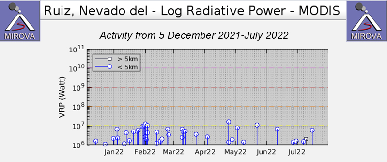 |
Figure 137. Intermittent thermal anomalies were detected at Nevado del Ruiz during December 2021 through July 2022, according to this MIROVA graph (Log Radiative Power). A larger number of anomalies occurred during January through February, after which the frequency of the anomalies declined. Courtesy of MIROVA. |
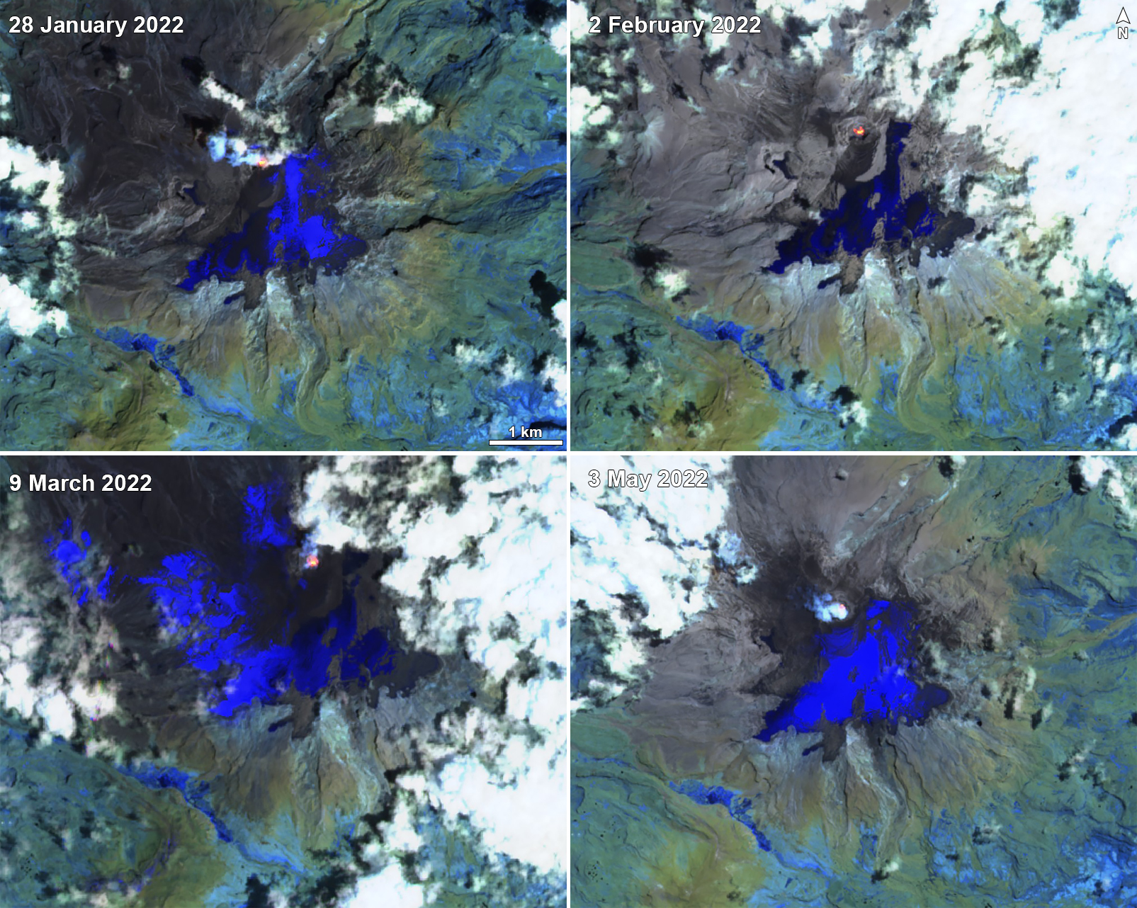 |
Figure 138. Sentinel-2 infrared satellite images showed occasional small thermal anomalies at the summit crater of Nevado del Ruiz on 28 January 2022 (top left), 2 February 2022 (top right), 9 March 2022 (bottom left), and 3 May 2022 (bottom right). White gas-and-steam emissions were intermittently observed in these images as well. Images use Atmospheric penetration rendering (bands 12, 11, 8a). Courtesy of Sentinel Hub Playground. |
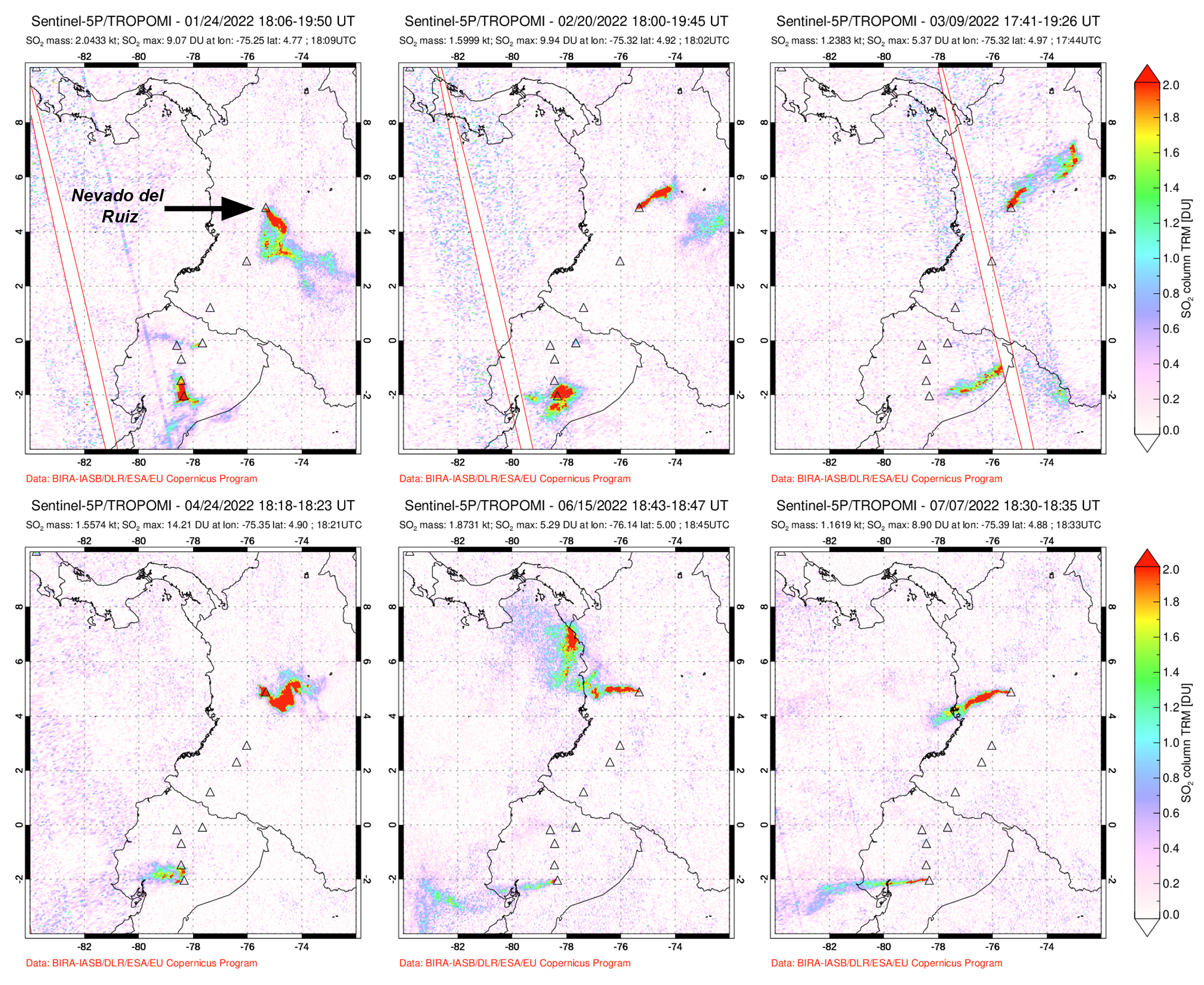 |
Figure 139. Sulfur dioxide emissions from Nevado del Ruiz were frequently recorded throughout January through July 2022 with the TOPOMI instrument on the Sentinel-5P satellite. Plumes drifted in different directions and often exceeded 2 Dobson Units (DU) on 24 January 2022 (top left), 20 February 2022 (top middle), 9 March 2022 (top right), 24 April 2022 (bottom left), 15 June 2022 (bottom middle), and 7 July 2022 (bottom right). Courtesy of NASA Global Sulfur Dioxide Monitoring Page. |
Activity during January and February was relatively low and mainly consisted of seismicity in the Arenas crater. Seismic events included continuous volcanic tremor, tremor pulses, harmonic tremor, long period, and very long period earthquakes of variable intensity; these events indicated fluid movements. Drumbeat type seismicity was reported on 3, 25, 28, and 30 January and 2, 3, 4, 10, 19, 23, 26, and 28 February. According to SGC, this type of seismicity is related to the continued lava dome growth at the bottom of the crater. Gas-and-steam plumes were intermittently reported, the highest of which rose as 2.2 km above the crater on 24 January and drifted in various directions. Some of the seismic signals were associated with ash emissions and incandescence was observed in webcam images. During the night of 3 and 4 February two small explosions were observed with a FLIR camera. Gas-and-steam emissions rose as high as 2.9 km above the crater on 23 February and drifted in multiple directions. Another small explosion was reported on 11 February, which included an ash plume that rose above the crater; the Washington VAAC issued a notice that reported an ash plume that rose to 7 km altitude and drifted N at 1130.
During March and April low activity consisting of dome growth, ash emissions, and seismicity persisted. Seismicity included continuous volcanic tremor, tremor pulses, long period, and very long period earthquakes, all of which varied in intensity. Intermittent gas-and-ash emissions were also reported. Drumbeat type events were recorded on 1, 8, 9, 10, 11, 13, 16, and 22 March. Gas-and-steam emissions rose as high as 2.2 km above the crater on 13 March and drifted in multiple directions. During 9-10 April gas-and-ash emissions rose 3.3 km and 3.2 km high above the crater at 1713 and 0858 and drifting N and SW, respectively. Minor ashfall around the volcano was reported by Parque Nacional Natural Los Nevados staff. It was also visible in webcam images and from the city of Manizales (25 km N). During 25-26 April ashfall deposits were reported in Manizales and Villamaría (28 km NW), relating to gas-and-ash emissions.
Seismicity and dome growth continued during May, June, and July with continuous volcanic tremor, tremor pulses, long period, and very long period earthquakes each of variable intensities. An ash plume at 0536 on 3 May rose 2.1 km above the crater and drifted W. Resulting ashfall was detected in the municipalities of Santa Rosa de Cabal (33 km W), Dosquebradas (40 km W), Pereira (40 km WSW), and Manizales. Continued gas-and-steam emissions rose as high as 3 km above the crater on 10 May and drifted in different directions. Drumbeat type events were detected on 5, 8, and 12 May and 2, 3, 6, 7, 11, 13, 14, 15, 18, 22, and 26 June. A gas-and-ash plume rose 3 km above the volcano at 0857 on 9 May and resulted in ashfall in Manizales, Villamaría, Chinchiná (30 km WNW), Pereira, Dosquebradas, and Santa Rosa. Ashfall deposits were also detected during 25 and 26 May in Manizales and other towns located to the W and NW of the volcano. On 22 June, ashfall was reported in Manizales. During July, drumbeat-type events occurred on 11, 12, 16, and 22 July.
Geological Summary. Nevado del Ruiz is a broad, glacier-covered volcano in central Colombia that covers more than 200 km2. Three major edifices, composed of andesitic and dacitic lavas and andesitic pyroclastics, have been constructed since the beginning of the Pleistocene. The modern cone consists of a broad cluster of lava domes built within the caldera of an older edifice. The 1-km-wide, 240-m-deep Arenas crater occupies the summit. The prominent La Olleta pyroclastic cone located on the SW flank may also have been active in historical time. Steep headwalls of massive landslides cut the flanks. Melting of its summit icecap during historical eruptions, which date back to the 16th century, has resulted in devastating lahars, including one in 1985 that was South America's deadliest eruption.
Information Contacts: Servicio Geologico Colombiano (SGC), Diagonal 53 No. 34-53 - Bogotá D.C., Colombia (URL: https://www.sgc.gov.co/volcanes); Washington Volcanic Ash Advisory Center (VAAC), Satellite Analysis Branch (SAB), NOAA/NESDIS OSPO, NOAA Science Center Room 401, 5200 Auth Rd, Camp Springs, MD 20746, USA (URL: www.ospo.noaa.gov/Products/atmosphere/vaac, archive at: http://www.ssd.noaa.gov/VAAC/archive.html); Sentinel Hub Playground (URL: https://www.sentinel-hub.com/explore/sentinel-playground); NASA Global Sulfur Dioxide Monitoring Page, Atmospheric Chemistry and Dynamics Laboratory, NASA Goddard Space Flight Center (NASA/GSFC), 8800 Greenbelt Road, Goddard MD 20771, USA (URL: https://so2.gsfc.nasa.gov/).