Report on Popocatepetl (Mexico) — September 2022

Bulletin of the Global Volcanism Network, vol. 47, no. 9 (September 2022)
Managing Editor: Benjamin Andrews.
Edited by Kadie L. Bennis.
Popocatepetl (Mexico) Daily gas-and-steam emissions and occasional explosions during February-July 2022
Please cite this report as:
Global Volcanism Program, 2022. Report on Popocatepetl (Mexico) (Bennis, K.L., and Andrews, B., eds.). Bulletin of the Global Volcanism Network, 47:9. Smithsonian Institution.
Popocatepetl
Mexico
19.023°N, 98.622°W; summit elev. 5393 m
All times are local (unless otherwise noted)
Popocatépetl, located 70 km SE of Mexico City, Mexico, contains a 400 x 600 m wide summit crater. Records of activity date back to the 14th century. The current eruption period has been ongoing since January 2005 and has included numerous episodes of lava-dome growth and destruction within the summit caldera. Recent activity has consisted of continuous minor ash emissions and crater incandescence (BGVN 47:04). This report covers the period from February through July 2022, characterized by daily low-intensity gas-and-ash emissions, volcano-tectonic tremors, and crater incandescence, based on information from México's Centro Nacional de Prevención de Desastres (CENAPRED) and various satellite data.
Gas-and-steam emissions, some of which contained ash, continued from February through July 2022. CENAPRED reported the number of low-intensity gas-and-ash emissions or “exhalations” and the number of minutes of tremor in their daily reports (figure 192). A total of 120 volcano-tectonic (VT) tremors were detected throughout the reporting period. The average number of gas-and-ash emissions was 26 per day, with a maximum number of 86 on 24 February. Strong sulfur dioxide plumes were often visible in satellite data from the TROPOMI instrument on the Sentinel-5P satellite (figure 193).
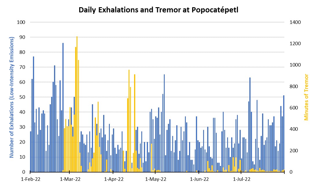 |
Figure 192. CENAPRED reported the number of daily “exhalations” (in blue, left scale), and the number of minutes of tremor (in gold, right scale) at Popocatépetl each day during February through July 2022. The number of daily exhalations fluctuated throughout the period, reaching as high as 86 on 24 February 2022 and continuing to fluctuate. There were five distinct periods of tremor that occurred during late February to mid-March, late March, mid-April, late April to early May, and June through July. On 6 March a maximum duration of 1,265 minutes of tremor was detected. Data from CENAPRED daily reports. |
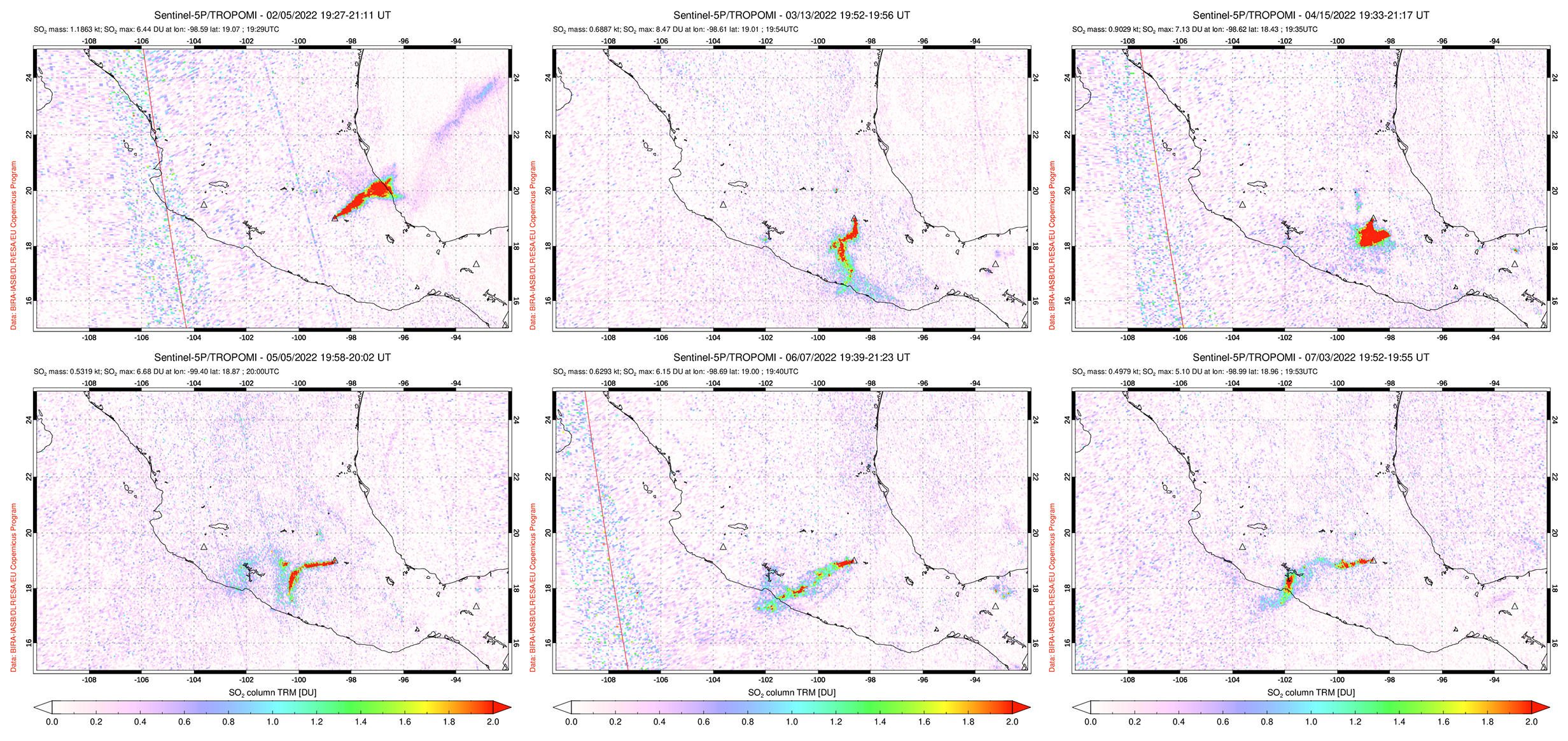 |
Figure 193. Moderate to strong sulfur dioxide plumes were detected at Popocatépetl and drifted in different directions, as seen on 5 February 2022 (top left), 13 March 2022 (top middle), 15 April 2022 (top right), 5 May 2022 (bottom left), 7 June 2022 (bottom middle), and 3 July 2022 (bottom right). Courtesy of NASA Global Sulfur Dioxide Monitoring Page. |
During February through March, daily gas-and-steam and minor ash emissions were reported, along with intermittent tremor starting in late February. There were 42 VT-type events detected during the two months. On average, 32 exhalations occurred each day, which consisted mostly of water vapor, volcanic gases, and a small amount of ash. On 17 February at 0715 a minor explosion was detected (figure 194). On 23 February personnel from the Institute of Geophysics of the National Autonomous University of Mexico (UNAM) and the Center National for Disaster Prevention (CENAPRED), with the support of the National Guard, conducted an overflight of the volcano. They reported that the interior of the crater had an approximate diameter of 390-410 m and a depth of 160-200 m (figure 194). Remains of lava domes were also visible on the bottom of the crater. Slight ashfall was reported during 23-24 February in Atlautla, Ozumba, and Tepetlixpa. A moderate explosion was reported on 4 March at 0959 (figure 195). On 8 March, three low-intensity exhalations recorded at 0617, 0620, and 0623 were accompanied by an increase in ash emissions that drifted NE. A moderate explosion was reported on 29 March, which resulted in slight ashfall was reported in San Pedro Benito Juárez, a municipality of Atlixco on 30 March.
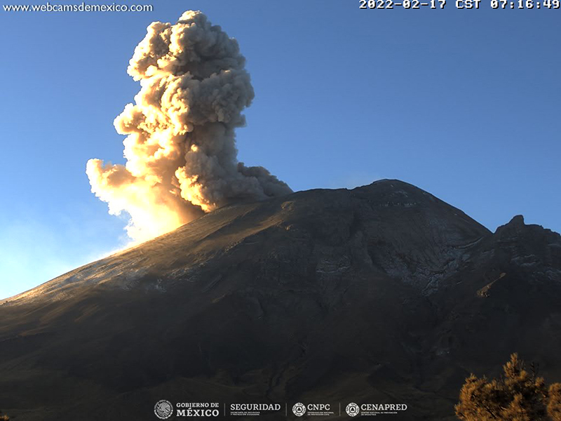 |
Figure 194. Webcam image showing a strong gas-and-ash plume rising above Popocatépetl on 17 February 2022. Courtesy of CENAPRED daily report. |
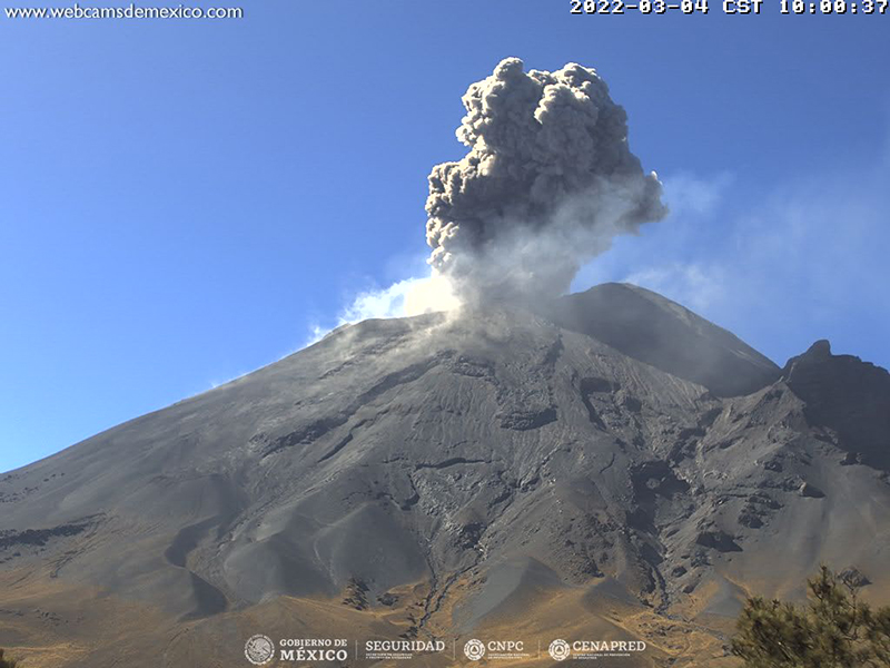 |
Figure 195. Webcam image showing an ash plume rising about Popocatépetl on 4 March 2022. Courtesy of CENAPRED daily report. |
During April through July, activity remained consistent with daily gas-and-steam emissions that sometimes contained minor amounts of ash, and occasional tremor events. There were 78 VT-type events that occurred during this time and an average of 23 daily exhalations were reported. Two minor explosions were reported on 21 April at 0152 and 0559. On 30 April some nighttime incandescence was visible (figure 196). An exhalation reported at 0728 on 1 June ejected some ash that rose 500 m high and drifted SW. A small exhalation occurred on at 0913 on 28 June that ejected minor ash emissions to 1 km high and drifted WNW. A low intensity exhalation at 1826 on 1 July ejected small amounts of ash that rose 2.5 km high and drifted NW.
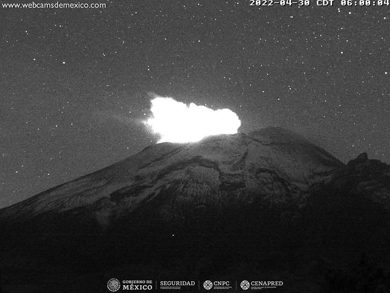 |
Figure 196. Webcam image showing nighttime crater incandescence from Popocatépetl on 30 April 2022. Courtesy of CENAPRED daily report. |
MODIS thermal anomaly data provided through MIROVA (Middle InfraRed Observation of Volcanic Activity) showed low- to moderate-level intermittent thermal activity during February through July, with a period of low activity during March through mid-April (figure 197). According to data from MODVOLC thermal alerts, a total of five hotspots were detected at the summit on 7 April, 29 May, 30 June, and 12, 19, and 23 July. Hotspots were also visible in the summit crater in infrared satellite data from Sentinel-2 (figure 198).
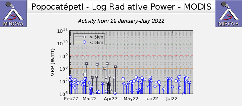 |
Figure 197. The MIROVA graph of thermal anomalies at Popocatépetl from 29 January through July 2022 shows low- to moderate-level, intermittent activity during February through July, with a period of low activity during March through mid-April. Courtesy of MIROVA. |
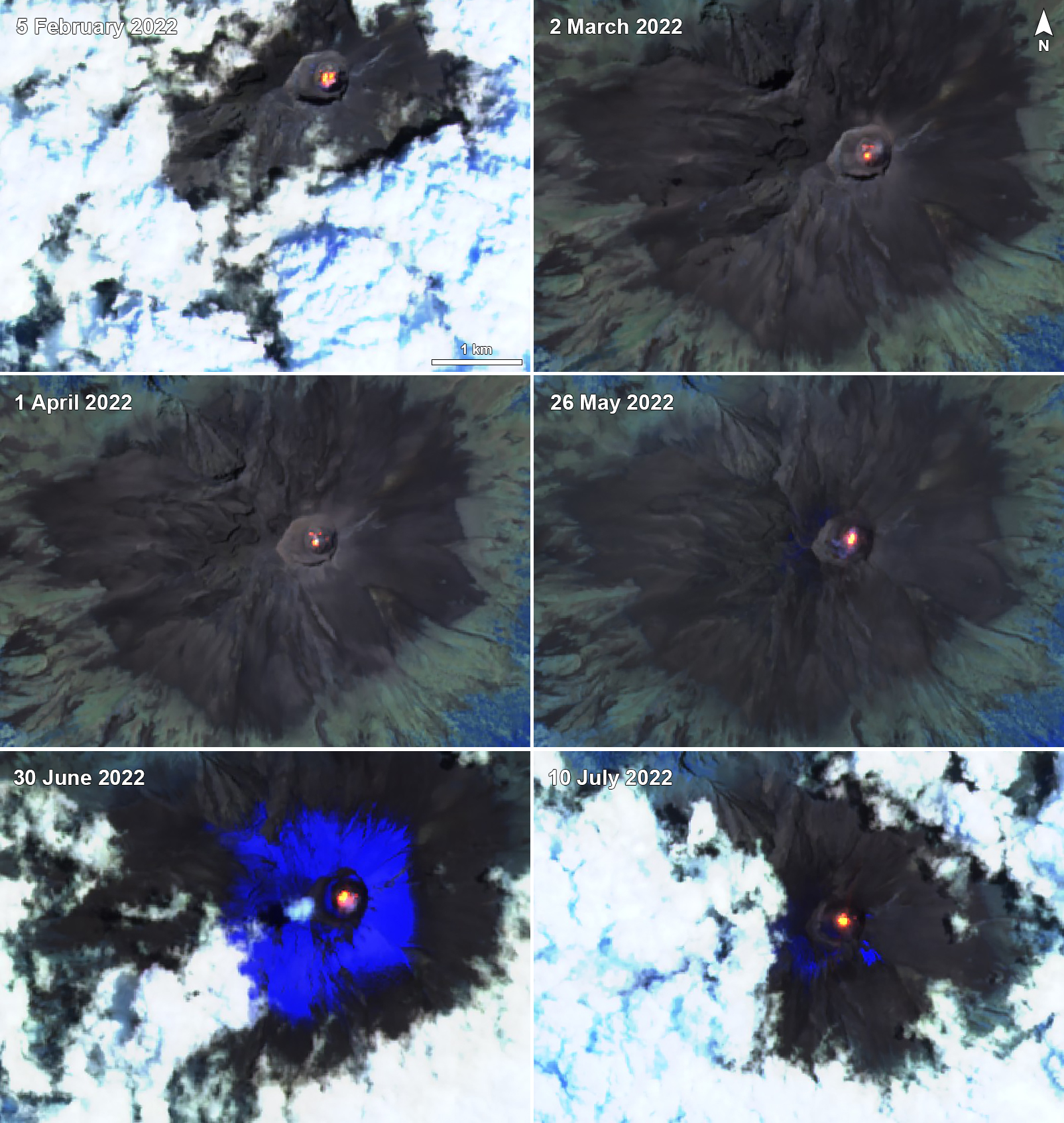 |
Figure 198. Sentinel-2 infrared satellite images showing thermal anomalies in the summit crater of Popocatépetl on 5 February (top left), 2 March (top right), 1 April (middle left), 26 May (middle right), 30 June (bottom right), and 10 July 2022 (bottom right). Occasional gas-and-steam emissions accompanied these anomalies. Images use Atmospheric penetration rendering (bands 12, 11, 8a). Courtesy of Sentinel Hub Playground. |
Geological Summary. Volcán Popocatépetl, whose name is the Aztec word for smoking mountain, rises 70 km SE of Mexico City to form North America's 2nd-highest volcano. The glacier-clad stratovolcano contains a steep-walled, 400 x 600 m wide crater. The generally symmetrical volcano is modified by the sharp-peaked Ventorrillo on the NW, a remnant of an earlier volcano. At least three previous major cones were destroyed by gravitational failure during the Pleistocene, producing massive debris-avalanche deposits covering broad areas to the south. The modern volcano was constructed south of the late-Pleistocene to Holocene El Fraile cone. Three major Plinian eruptions, the most recent of which took place about 800 CE, have occurred since the mid-Holocene, accompanied by pyroclastic flows and voluminous lahars that swept basins below the volcano. Frequent historical eruptions, first recorded in Aztec codices, have occurred since Pre-Columbian time.
Information Contacts: Centro Nacional de Prevención de Desastres (CENAPRED), Av. Delfín Madrigal No.665. Coyoacan, México D.F. 04360, México (URL: http://www.cenapred.unam.mx/, Daily Report Archive https://www.gob.mx/cenapred/archivo/articulos); MIROVA (Middle InfraRed Observation of Volcanic Activity), a collaborative project between the Universities of Turin and Florence (Italy) supported by the Centre for Volcanic Risk of the Italian Civil Protection Department (URL: http://www.mirovaweb.it/); Hawai'i Institute of Geophysics and Planetology (HIGP) - MODVOLC Thermal Alerts System, School of Ocean and Earth Science and Technology (SOEST), Univ. of Hawai'i, 2525 Correa Road, Honolulu, HI 96822, USA (URL: http://modis.higp.hawaii.edu/); NASA Global Sulfur Dioxide Monitoring Page, Atmospheric Chemistry and Dynamics Laboratory, NASA Goddard Space Flight Center (NASA/GSFC), 8800 Greenbelt Road, Goddard, Maryland, USA (URL: https://so2.gsfc.nasa.gov/); Sentinel Hub Playground (URL: https://www.sentinel-hub.com/explore/sentinel-playground).