Report on Ioto (Japan) — January 2023
Bulletin of the Global Volcanism Network, vol. 48, no. 1 (January 2023)
Managing Editor: Edward Venzke.
Edited by Kadie L. Bennis.
Ioto (Japan) Submarine eruption with discolored water, pumice, and gas emissions during July-December 2022
Please cite this report as:
Global Volcanism Program, 2023. Report on Ioto (Japan) (Bennis, K.L., and Venzke, E., eds.). Bulletin of the Global Volcanism Network, 48:1. Smithsonian Institution.
Ioto
Japan
24.751°N, 141.289°E; summit elev. 169 m
All times are local (unless otherwise noted)
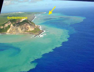
Ioto (Iwo-jima), located about 1,200 km S of Tokyo, lies within a 9-km-wide submarine caldera along the Izu-Bonin-Mariana volcanic arc. Previous eruptions date back to 1889 and have consisted of dominantly phreatic explosions, pumice deposits during 2001, and discolored water (figure 7). An eruption during February-May 2012 included small phreatic eruptions, mud ejections, tremor events, discolored water, and some gas-and-steam and ash emissions (BGVN 37:07). This report updates information since May 2012, covering multiple small events on the island and offshore, through the July-December 2022 submarine eruption that included pumice, black ejecta, and discolored water. Information primarily comes from the Japan Meteorological Association (JMA), the Japan Coast Guard (JCG), and satellite data.
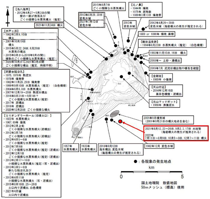 |
Figure 7. Map of Ioto showing the locations of recorded eruptions from 1889 through December 2022. The most recent eruption in 2022 is highlighted in red just off the SE coast of the island and E of the 2001 eruption site. From Ukawa et al. (2002), modified by JMA. |
Activity during June-December 2012. Activity was relatively quiet after May 2012, with occasional white fumaroles seen by the Japan Coast Guard (JCG). Intermittent volcanic earthquakes and tremors also occurred. On 9 July 2012 the Japan Maritime Self Defense Force (JMSDF) reported that a white volcanic plume rose 15 m high around 1215 on the W side of the island. At 1330 mud was ejected tens of meters high; JMA noted that this activity occurred due to a small phreatic explosion, and no associated earthquakes, shock waves, or volcanic tremors were recorded.
On 1 December 2012 JMSDF reported that there were traces of mud ejections in the same location as the July 2012 activity on the W side of the island, with deposits scattered about 10 m from the vent. JMA compared this event to activity during February-April 2012 and reported that it was also possibly a small phreatic explosion.
Activity during 2013. Reports from JMSDF noted that on 18 February 2013 mud had erupted around the former crater known as “Million Dollar Hole” (a depression along the Asodai fault) and included rocks with diameters up to 40 cm. The deposits were mainly scattered about 150 m W. JMSDF identified this event as a small phreatic explosion, similar but larger than those that occurred in 2012.
On 6 March an overflight by JMA allowed observations of a new depression in the Million Dollar Hole that measured about 15 m in diameter. Though no new deposits were visible around the depression, and the exact date and time of the event were unknown, larger volcanic earthquakes from 1800 on 5 March to 0600 on 6 March indicated a small phreatic explosion.
A black plume was visible rising about 400 m above Million Dollar Hole on the W side of the island at 1600 on 11 April, according to a report from JMSDF (figure 8). Volcanic material was also deposited, and volcanic tremor lasted about eight minutes and 50 seconds starting around 1559. These events indicated that a small phreatic explosion had occurred.
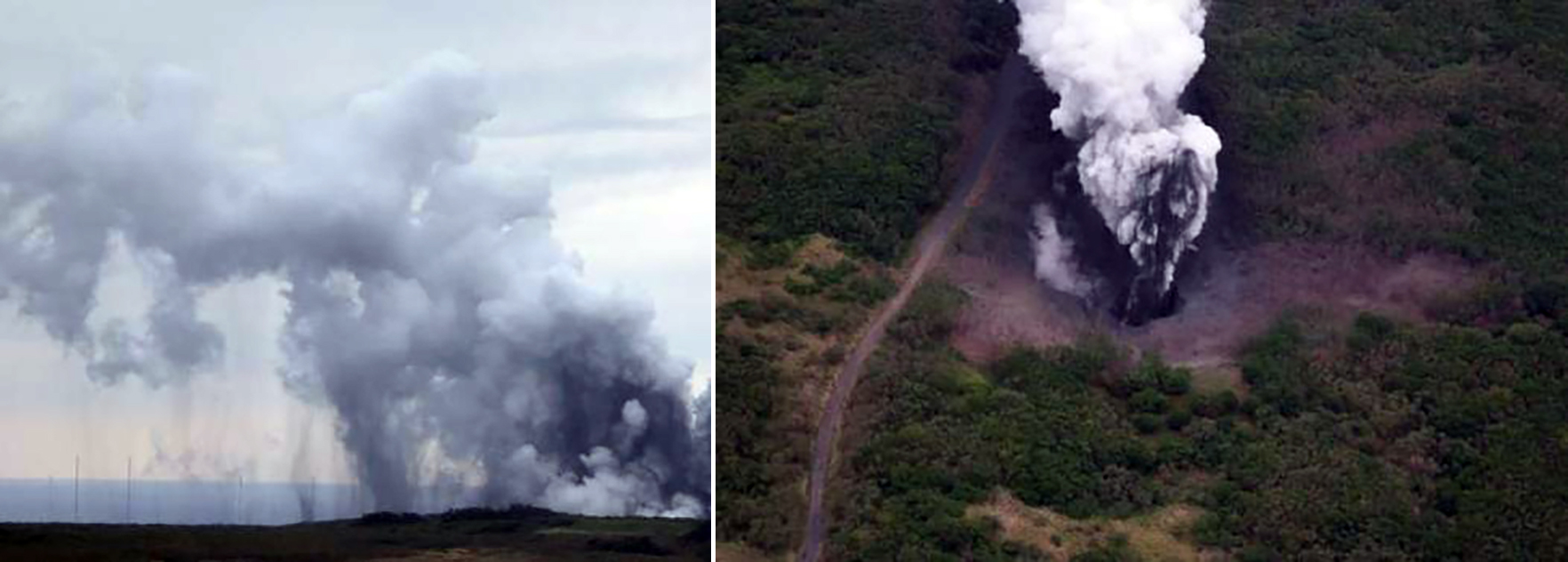 |
Figure 8. Photos of an eruption plume rising 400 m above Million Dollar Hole on the W side of Ioto on 11 April 2013. Around 1600 a small phreatic explosion occurred. Courtesy of JMSDF via JMA. |
Off the NE coast of the island near Kitanohana, aerial observations showed white discolored water on 21 August 2013. Further NW from this point, about 150 m off the coast and 300 m N of Kitanohana, on 28 and 30 August more discolored water was confirmed (figure 9).
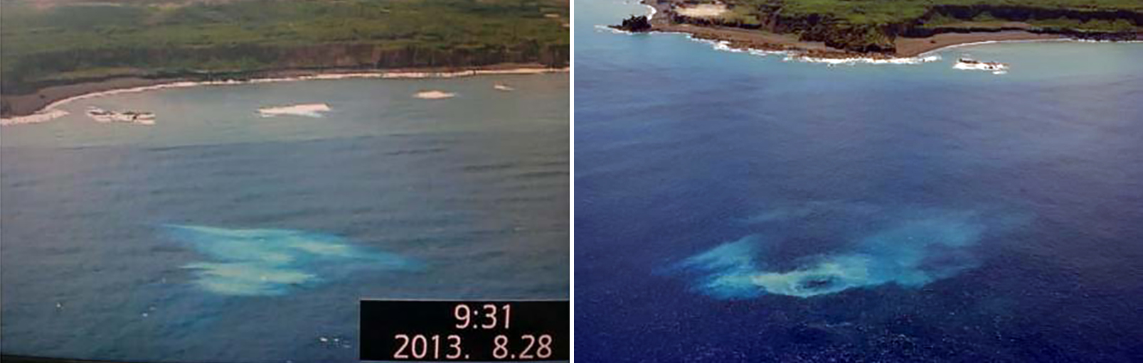 |
Figure 9. Photos of blue-yellow discolored water off the NE coast of Ioto near Kitanohana on 28 (left) and 30 (right) August 2013. Photo on the right has been color corrected. Courtesy of JMSDF via JMA. |
Activity during 2014-2019. Activity was relatively low during 2014-2019 with occasional seismicity, fumarolic activity, and small eruptions. On 22 May, 24 May, and 20 June 2015 gas-and-steam emissions rose 100-200 m high near the Idogahama Beach on the NW side of the island. Some fumarolic activity was also recorded up to 10 m at the Asodai Sinkhole. A small eruption was recorded near Kitanohana Beach on the N part of the island on 7 August 2015. Mud and rocks were scattered within about 27 m around the eruption vent.
Eruptive activity was reported by JMA during 31 August to 1 September 2016; the National Research Institute for Earth Science and Disaster Prevention confirmed that new volcanic blocks had been ejected about 50 m from the Asodai Sinkhole, accompanied by fumarolic activity. Intermittent fumarolic activity continued through December 2017.
JMA reported that during 8-14 September 2018 the number of volcanic earthquakes increased, and for the first time since April 2012 the daily number of earthquakes exceeded 600. The number of earthquakes decreased slightly after 8 September but remained high through the 14th. During a JMSDF overflight on 12 September 2018 seawater jetting was observed 5-10 m above the ocean surface on the S coast, which JMSDF suggested may have been a submarine eruption. In addition, discolored water was also visible.
Activity during 2020-June 2022. During 2020-2021, activity remained relatively low. An aerial observation conducted by JCG on 4 February 2020 reported that there was discolored water off the W (Chidorigahama) and SE (Okinahama) coasts of the island (figure 10). A small eruption occurred at the Asodai Sinkhole at 1948 on 28 December 2020, which generated a plume that rose 400 m high (figure 11). Volcanic tremors were detected around this time as well. A field survey conducted by JMSDF that night and the morning of 29 December identified volcanic blocks with diameters of 20 cm that had been ejected 50-100 m from the sinkhole; mud deposits were also noted.
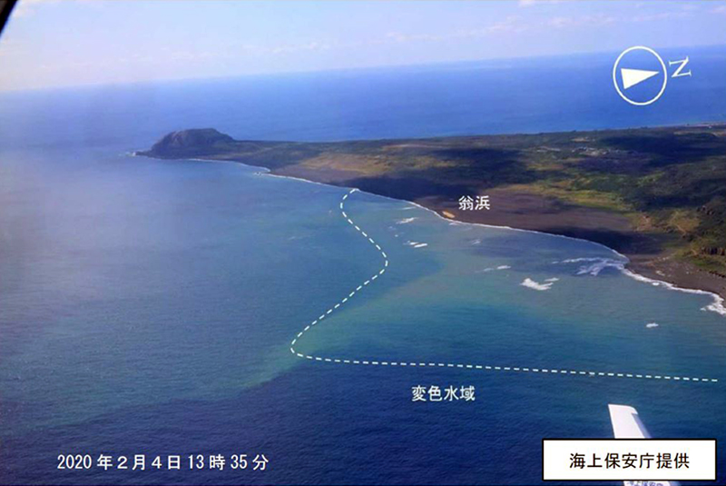 |
Figure 10. Photo of yellow discolored water off the SE coast of Ioto on 4 February 2020. Photo has been color corrected. Courtesy of JCG via JMA. |
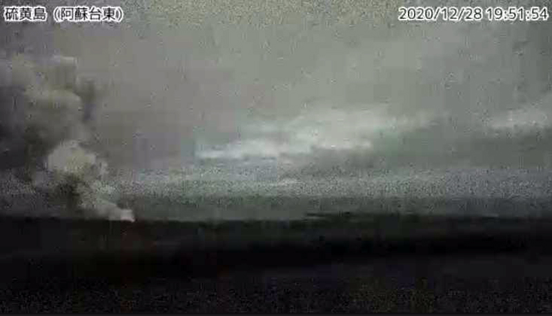 |
Figure 11. Webcam image showing an eruption plume rising 400 m above the Asodai Sinkhole on the NW side of Ioto at 1951 on 28 December 2020. Courtesy of JMA. |
A surveillance camera, located approximately 900 m ENE of the Asodai Sinkhole on the W side of the island, showed a fumarolic plume rising less than 200 m high on 6 January 2021. Then, on 1 February 2021 a gray eruption plume was detected rising 20 m high at 0905. Mud eruptions around this time were also confirmed at the Asodai Sinkhole. During March 2021 yellowish discolored water was observed near the SE coast. Based on information from JMSDF, a helicopter overflight on 5 April reported that there were dried traces of mud eruptions in the Million Dollar Hole. JMA suggested that several days had passed since the mud eruption occurred. Discolored water was observed during an overflight on 12 July 2021 off the northern NW (Tamehachi) coast.
Off the SE coast (Okinahama), columns of water were reported by JMSDF to be rising from several to tens of meters high during 12 August, 23-26 August, 2-3 September, and 17 September 2021. The JCG reported bluish-white discolored water, gray particles, and bubbles seen during an overflight on 26 August and 12 September off the SE coast (figure 12). On 24 November JMSDF reported that a white volcanic plume rose 60 m high around 0540 from the NW side of the island; occasional gray ejecta rose 20-30 m high that same day NE from the site of the white plume. This activity was accompanied by an increase in volcanic earthquakes and tremor during 23-26 November.
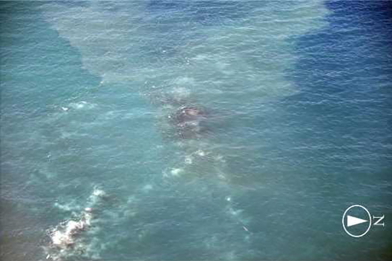 |
Figure 12. Photo of gray particles and discolored water observed off the SE (Okinahama) coast of Ioto on 26 August 2021. Courtesy of JMA. |
Activity during July-August 2022. JMA reported that minor eruptive activity, such as fumaroles, ejecta, and discolored plumes were observed off the SE coast of Ioto each day during 11-31 July 2022. JCG observed brown discolored water beginning on 11 July off the SE coast (figure 13). A column of water containing black ejecta rose meters to tens of meters at intervals of several minutes. On 14 July pumice clasts from the eruption washed onto shore at Okinahama and were photographed by the National Research Institute for Earth Science and Disaster Prevention during a field survey (figure 14). Aerial observations conducted by JCG on 15 July revealed bubbles near the eruptive vent. Additionally, a Sentinel-2 satellite image showed that on 15 July a dark spot off the SE coast near the 2001 vent location was the source of a green-yellow plume of discolored water that drifted NE (figure 15).
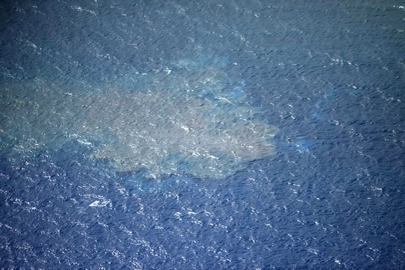 |
Figure 13. Photo showing brown discolored water first appearing off the SE (Okinahama) coast of Ioto on 11 July 2022. Photo has been color corrected. The scale of the affected area was not recorded. Courtesy of Japan Coast Guard. |
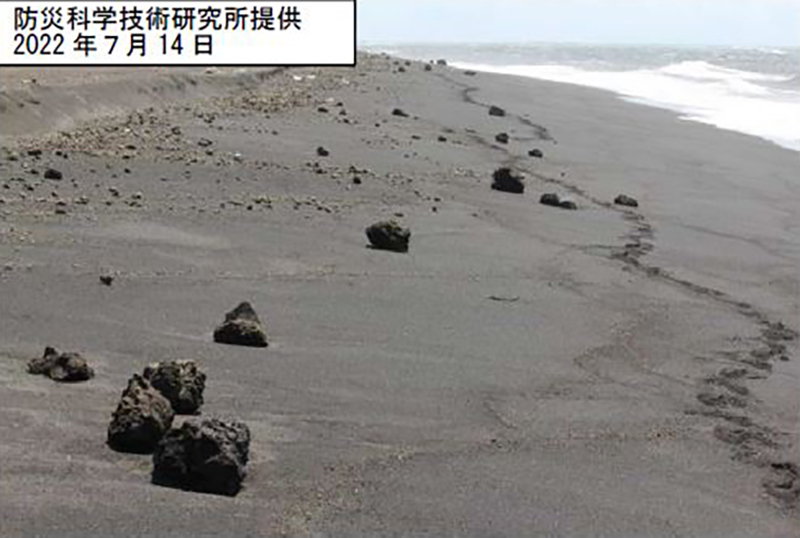 |
Figure 14. Photo of rocks on Okinahama (SE coast beach) thought to have originated from a submarine eruption of Ioto. Photo was taken on 14 July 2022 by the National Research Institute for Earth Science and Disaster Resilience. Courtesy of JMA. |
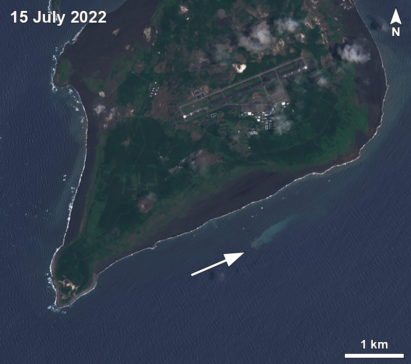 |
Figure 15. Sentinel-2 satellite image showing a dark spot of water off the SE coast of Ioto with a discolored plume drifting NE on 15 July 2022. The location of this activity was near the 2001 vent. Image with “Natural color” rendering (bands 4, 3, 2). Courtesy of Sentinel Hub Playground. |
Video taken around 25 July showed a white plume rising from the same location. Satellite images during 30-31 July showed small, rounded gray zones on the surface of the water (figure 16). JMA scientists visited the site on 31 July and confirmed pumice deposits on the beach (figure 17) and noted offshore eruptive activity every few minutes consisting of gray, tephra-laden columns of water rising 20-30 m above the ocean surface (figure 18). On 1 August a photo showed white gas-and-steam emissions rising above the submarine vent, accompanied by floating pumice deposits (figure 19). Another small, rounded gray zone in the water was also captured in a 4 August satellite image (figure 16); an associated discolored plume of water was visible drifting NE. Activity remained relatively low after 9 August, according to JMA, though disturbed water and a green-blue discolored plume in the same area was seen by the JCG on 23 August (figure 20).
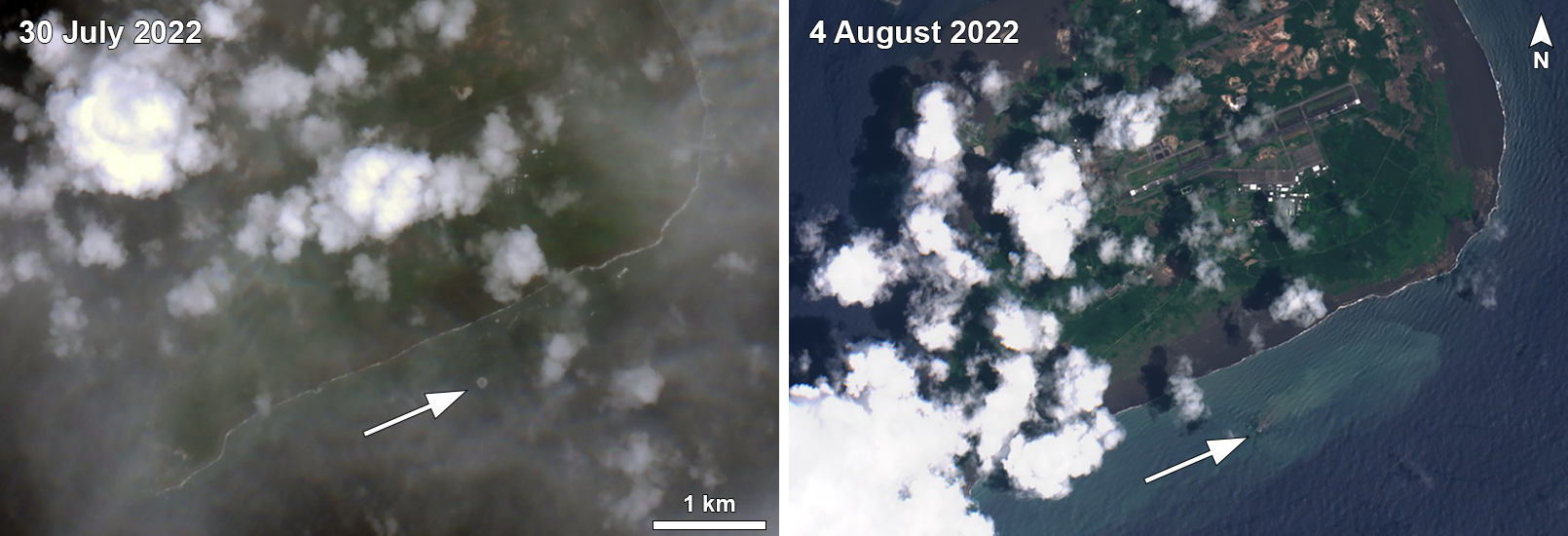 |
Figure 16. Sentinel-2 satellite image showing a small, rounded, gray zone at the surface of the water off the SE coast of Ioto on 30 July 2022 (left) and 4 August 2022 (right). A yellow-green discolored plume was visible on 4 August drifting NE. Image with “Natural color” rendering (bands 4, 3, 2). Image on the left has been color corrected due to cloud cover. Courtesy of Sentinel Hub Playground. |
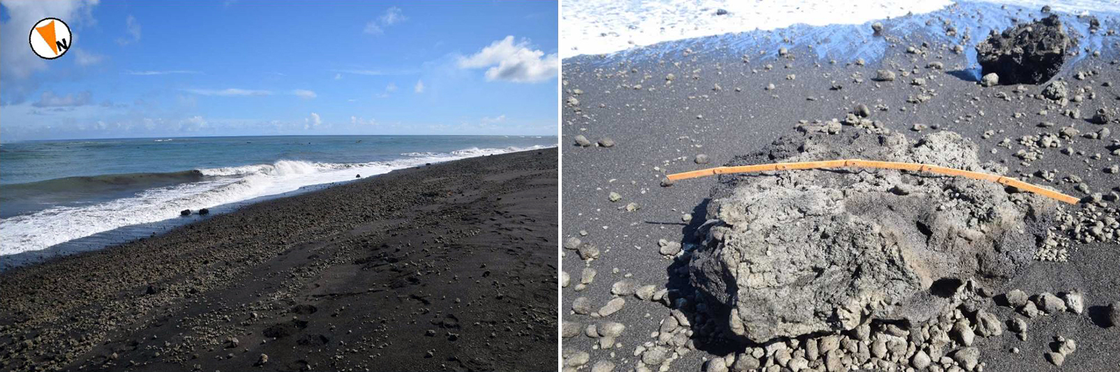 |
Figure 17. Photos showing pumice deposited on Okinahama (SE coast beach) from the Ioto submarine eruption on 31 July 2022. The size of the clast shown here on the right is 90 cm in length. Courtesy of JMA. |
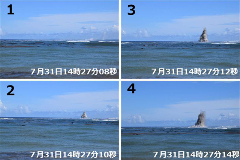 |
Figure 18. Photos showing the submarine eruption at Ioto taken from the SE coast of the island around 1427 on 31 July 2022. The dark water column was ejected 20-30 m high. Courtesy of JMA. |
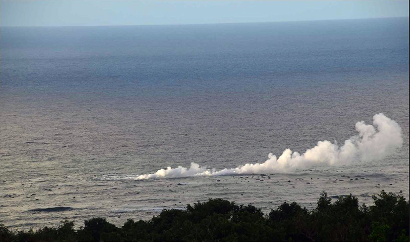 |
Figure 19. Photo of white gas-and-steam emissions on 1 August 2022 rising above the submarine eruptive vent off the SE coast of Ioto, accompanied by floating pumice deposits. Photo has been color corrected. Courtesy of JMA. |
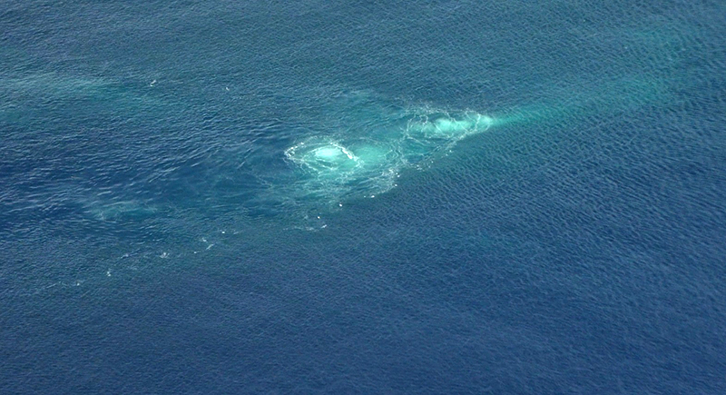 |
Figure 20. Photo of a blue-green discolored water plume off the SE (Okinahama) coast of Ioto on 23 August 2022. Photo has been color corrected. The scale of the affected area was not recorded. Courtesy of Japan Coast Guard. |
Activity during September-December 2022. JMSDF reported that discolored water on the evening of 4 October was visible off the SE coast, in the same location as the activity during July-August, which was followed by an eruption during 5-8 October. A column of water containing black ejecta rose meters to several tens of meters above the ocean surface at several minute intervals. An overflight on 12 October confirmed a discolored water plume off the SE coast (figure 21) that drifted NE from the same source as the July-August activity.
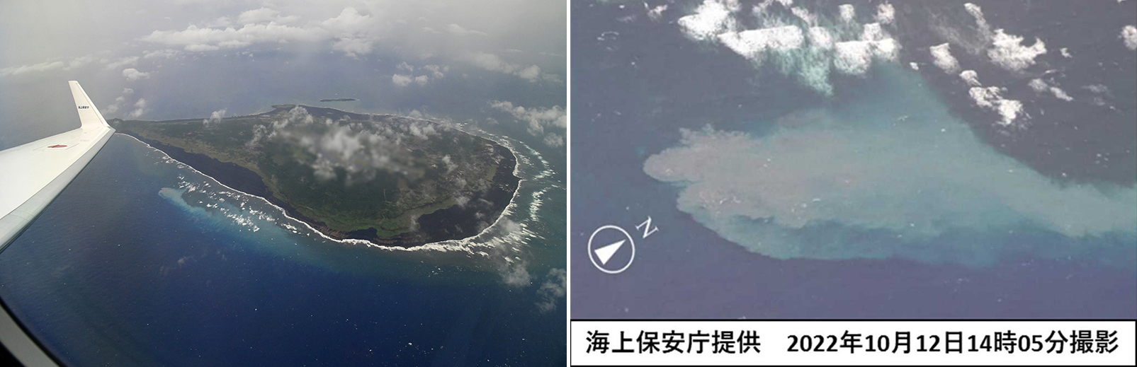 |
Figure 21. Photos of a strong discolored water plume off the coast of Ioto near Okinahama taken on 12 October 2022. Photo on the left has been color corrected. Courtesy of JCG (left) and JMA (right). |
According to JMSDF an eruption during 7-11 December 2022 included black ejecta rising to tens of meters above the ocean surface in about ten-minute intervals. On 9 December pumice clasts may have been spotted floating on the water. Discolored water was visible on 13 December near the same eruptive vent active during July-August and October.
References. Ukawa, M., Fujita, E., Kobayashi, T., 2002, Recent volcanic activity of Iwo Jima and the 2001 eruption, Monthly Chikyu, Extra No. 39, 157-164.
Geological Summary. Ioto, in the Volcano Islands of Japan, lies within a 9-km-wide submarine caldera. The volcano is also known as Ogasawara-Iojima to distinguish it from several other "Sulfur Island" volcanoes in Japan. The triangular, low-elevation, 8-km-long island narrows toward its SW tip and has produced trachyandesitic and trachytic rocks that are more alkalic than those of other volcanoes in this arc. The island has undergone uplift for at least the past 700 years, accompanying resurgent doming of the caldera; a shoreline landed upon by Captain Cook's surveying crew in 1779 is now 40 m above sea level. The Motoyama plateau on the NE half of the island consists of submarine tuffs overlain by coral deposits and forms the island's high point. Many fumaroles are oriented along a NE-SW zone cutting through Motoyama. Numerous recorded phreatic eruptions, many from vents on the W and NW sides of the island, have accompanied the uplift.
Information Contacts: Japan Meteorological Agency (JMA), 1-3-4 Otemachi, Chiyoda-ku, Tokyo 100-8122, Japan (URL: http://www.jma.go.jp/jma/indexe.html); Japan Coast Guard (JCG) Volcano Database, Hydrographic and Oceanographic Department, 3-1-1, Kasumigaseki, Chiyoda-ku, Tokyo 100-8932, Japan (URL: https://www1.kaiho.mlit.go.jp/GIJUTSUKOKUSAI/kaiikiDB/kaiyo22-2.htm); Sentinel Hub Playground (URL: https://www.sentinel-hub.com/explore/sentinel-playground).