Report on Pavlof (United States) — February 2023

Bulletin of the Global Volcanism Network, vol. 48, no. 2 (February 2023)
Managing Editor: Edward Venzke.
Research and preparation by Paul Berger.
Pavlof (United States) Ongoing ash explosions and lava flows until eruptive activity ended on 7 December 2022
Please cite this report as:
Global Volcanism Program, 2023. Report on Pavlof (United States) (Venzke, E., ed.). Bulletin of the Global Volcanism Network, 48:2. Smithsonian Institution.
Pavlof
United States
55.417°N, 161.894°W; summit elev. 2493 m
All times are local (unless otherwise noted)
Pavlof, one of the most consistently active volcanoes in the Aleutian Islands, has been erupting since mid-November 2021, with frequent weak explosions, periods of lava spatter, fountaining, small lava flows and emissions of steam and gas that sometimes contained ash (BGVN 47:08). This eruption continued through 7 December 2022, when both explosions and significant thermal activity had stopped (figure 24). The current report, which describes activity between August 2022-January 2023, is monitored remotely by the Alaska Volcano Observatory (AVO) using local seismic and infrasound sensors, satellite data, web cameras, and remote infrasound and lightning networks, and the information below is based on AVO weekly reports and satellite data. During August to mid-December 2022, the Aviation Color Code (AVO) remained at Orange and the Volcano Alert Level (VAL) remained at Watch, the second highest level for both on a four-level scale, after which they were lowered. Weather clouds often prevented satellite and webcam views.
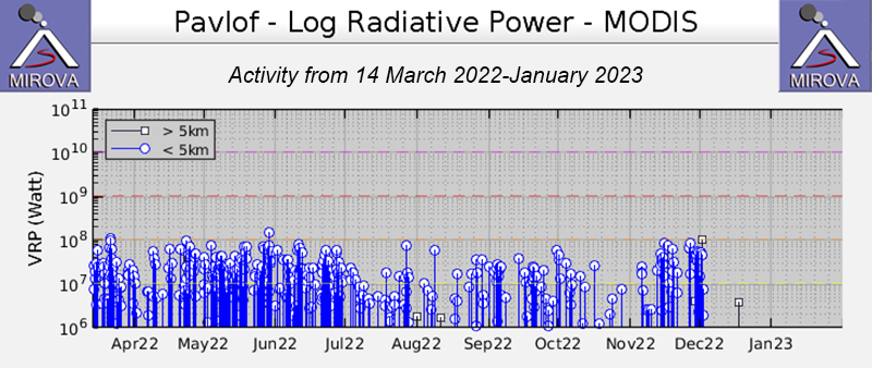 |
Figure 24. Graph of thermal anomalies at Pavlof during April 2022-March 2023, as recorded by the MIROVA system. Frequent mostly moderate power hotspots were identified during August through early December 2022. Courtesy of MIROVA. |
During August, the minor eruption from the active vent on the E flank, just below the summit, continued, with occasional explosions that probably produced minor ash emissions (figure 24) that usually rose no higher than an altitude of 3 km and dissipated quickly. According to a pilot report, a small ash emission rose to an altitude of about 4 km on 24 August. A small pyroclastic debris flow was observed in satellite data on 26 August, extending about 590 m SE from the active vent. Seismic tremor persisted, and elevated surface temperatures were identified almost daily in satellite images. No active lava flows extending down the flank were detected.
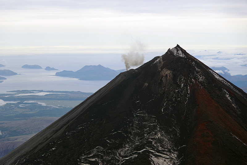 |
Figure 25. A typical small ash plume is visible rising from Pavlof in this aerial photo at 1123 on 26 August. Photo by Pavel Izbekov; courtesy of AVO/University of Alaska Fairbanks, Geophysical Institute. |
By 2 September a second small vent had re-opened ESE of the main vent. Elevated surface temperatures in the active vent area were identified in satellite images on most days, consistent with minor lava effusion. Strong incandescence at the vent and from an area within 200 m downslope was visible in webcam images starting on 14 September, indicating a short lava flow. Small explosions were detected during 18-21 September, and steam and gas plumes often containing minor amounts of ash were frequently visible. New lahar and minor ash deposits extending less than 900 m from the vent were visible during 11-13 September. Seismic tremor was nearly continuous in September.
Small explosions and persistent seismic tremor continued during October except for the first week, multiple explosions were recorded almost daily. Strongly elevated surface temperatures were often identified in satellite images, incandescence and glowing ejected rock fragments were frequently visible in nighttime webcam images, and diffuse steam plumes were sometimes visible in webcam views. Discolored snow near the vent was visible in webcam images on the morning of 7 October, suggesting low-level explosive activity; a small explosion was recorded at 1503 that same day. Webcam images on 20 October showed a new dark flow of lava and debris extending about a third of the way down the E flank. During 31 October-1 November, a diffuse steam-and-ash plume rose less than 3 km in altitude and deposited minor amounts of tephra on the E flank.
During November, multiple explosions were detected almost daily until mid-month, after which none were clearly recorded, but seismic tremor was nearly continuous. Webcam images taken on 12 and 15 November showed a lava flow and ash deposits on the upper flanks, and nighttime crater incandescence was sometimes visible. Elevated surface temperatures were observed in satellite data on most days, and occasional clear webcam views showed recent flow deposits on the volcano’s flank as well as weak steaming and light ash emissions and deposits, probably associated with lava spattering or fountaining. On 28 November, a flowage event likely resulting from the interaction of hot rocks with ice and snow on the flank was observed in seismic data and a series of webcam images, and satellite and webcam images showed that the deposit extended about 5 km down the SE flank, the largest flowage event during the current eruptive period. This event produced an ash and gas plume that reached an altitude as high as 6 km, before dissipating within tens of minutes.
Multiple small explosions were detected on 1-3 December that resulted in a narrow gully being eroded in the ice below the vent, extending about 2 km down the flank. Elevated surface temperatures and incandescent lava were not observed after 2 December. Activity significantly decreased after 3 December, with AVO reporting that the last explosion was detected on 7 December. Occasional small steam and gas plumes were visible in webcam images. Tremor had become more intermittent by mid-month, but overall seismicity remained above background levels through the end of December. On 17 December, due to the reduced activity, AVO decreased the ACC to Yellow and the VAL to Advisory, both the second lowest on a four-level scale. Weakly elevated temperatures were detected the last week of December, and a high-resolution satellite image on 27 December showed a small spot of strongly elevated temperatures within the recently active vent on the volcano’s upper E flank, but there was no sign of eruptive activity.
During the first two weeks of January 2023, seismicity remained above background levels and weakly elevated surface temperatures and minor steaming from the active vent were observed that AVO suggested might have been associated with the cooling of lava around the vent. However, no explosions or other eruptive activity was noted. By mid-January seismicity had decreased to background levels. On 19 January, AVO decreased the ACC and VAL to Green and Normal, respectively, stating that the eruption had ended. However, weakly elevated surface temperatures and minor steaming from the recently active vent continued to be observed intermittently in satellite and web camera imagery, consistent with cooling of previously erupted lava.
Geological Summary. The most active volcano of the Aleutian arc, Pavlof is a Holocene stratovolcano that was constructed along a line of vents extending NE from the Emmons Lake caldera. Pavlof and Pavlof Sister to the NE form a dramatic pair of symmetrical, glacier-covered stratovolcanoes that overlook Pavlof and Volcano bays. Little Pavlof is a smaller cone on the SW flank of Pavlof volcano, near the rim of Emmons Lake caldera. Unlike Pavlof Sister, eruptions have frequently been reported from Pavlof, typically Strombolian to Vulcanian explosive eruptions from the summit vents and occasional lava flows. The active vents lie near the summit on the north and east sides. The largest recorded eruption took place in 1911, at the end of a 5-year-long eruptive episode, when a fissure opened on the N flank, ejecting large blocks and issuing lava flows.
Information Contacts: Alaska Volcano Observatory (AVO), a cooperative program of a) U.S. Geological Survey, 4200 University Drive, Anchorage, AK 99508-4667 USA (URL: https://avo.alaska.edu/), b) Geophysical Institute, University of Alaska, PO Box 757320, Fairbanks, AK 99775-7320, USA, and c) Alaska Division of Geological & Geophysical Surveys, 3354 College Rd., Fairbanks, AK 99709, USA (URL: http://dggs.alaska.gov/); Sentinel Hub Playground (URL: https://www.sentinel-hub.com/explore/sentinel-playground); MIROVA (Middle InfraRed Observation of Volcanic Activity), a collaborative project between the Universities of Turin and Florence (Italy) supported by the Centre for Volcanic Risk of the Italian Civil Protection Department (URL: http://www.mirovaweb.it/).