Report on Fuego (Guatemala) — March 2023

Bulletin of the Global Volcanism Network, vol. 48, no. 3 (March 2023)
Managing Editor: Benjamin Andrews.
Edited by Kadie L. Bennis.
Fuego (Guatemala) Daily explosions, ash plumes, ashfall, avalanches, and lahars during August-November 2022
Please cite this report as:
Global Volcanism Program, 2023. Report on Fuego (Guatemala) (Bennis, K.L., and Andrews, B., eds.). Bulletin of the Global Volcanism Network, 48:3. Smithsonian Institution.
Fuego
Guatemala
14.473°N, 90.88°W; summit elev. 3763 m
All times are local (unless otherwise noted)
Fuego is one of three stratovolcanoes that overlooks the city of Antigua, Guatemala and has been vigorously erupting since January 2002, with dated eruptions as old as 1531 CE. Volcanism has included major ashfalls, pyroclastic flows, lava flows, and lahars. Strong explosions generated large pyroclastic flows during June 2018, causing heavy damage in San Miguel Los Lotes, Alotenango, and El Rodeo, 10 km SSE of the summit; there were 169 reported fatalities and at least 256 people reported missing. Frequent explosions with ash plumes, block avalanches, and lava flows have persisted since 2018. More recently, activity remained relatively consistent with daily explosions, ash plumes, incandescent block avalanches of material, and ashfall (BGVN 47:08). This report covers similar activity during August through November 2022 using information from the Instituto Nacional de Sismologia, Vulcanología, Meteorología e Hidrologia (INSIVUMEH) daily reports and various satellite data.
Daily explosions were reported during August through November 2022 that generated shock waves and vibrations that rattled roofs and windows in communities near the volcano. Ash plumes rose to 4-5 km altitude each day and drifted as far as 30 km in different directions, though dominantly W and SW. The explosions also produced incandescent block avalanches that descended several flank drainages (barrancas), with some of the blocks reaching vegetation near the bottom. The affected drainages included Ceniza (SSW), Santa Teresa, Taniluyá (SW), Trinidad (S), Las Lajas (SE), Honda, and Seca (W). Incandescent pulses were visible as high as 450 m above the crater. Ashfall was also frequently reported in nearby communities (table 27). MIROVA (Middle InfraRed Observation of Volcanic Activity) analysis of MODIS satellite data showed frequent and strong thermal anomalies that remained relatively consistent throughout the reporting period, with a single short gap of fewer hotspots during mid-October (figure 164). A total of 54 MODVOLC thermal alerts were issued; 10 during August, 10 during September, 17 during October, and 17 during November. Some of this thermal activity was visible in Sentinel-2 infrared satellite imagery at the summit crater, which also showed occasional incandescent block avalanches descending multiple flanks (figure 165).
Table 27. Activity at Fuego during August-November 2022 included multiple explosions every hour that produced ash emissions that rose as high as 5 km altitude and drifted generally W and SW as far as 30 km from the volcano. Ashfall was reported in many communities around the volcano. Data from daily INSIVUMEH reports.
| Month | Explosions per hour | Ash plume altitude (km) | Ash plume distance (km) and direction | Communities reporting ashfall |
| Aug 2022 | 2-12 | 4-4.9 | 10-30 km W, SW, WSW, NW | Panimaché I and II, Morelia, Santa Sofía, Finca Palo Verde, El Porvenir, Sangre de Cristo, Yepocapa, Yucales, Ojo de Agua, and Acatenango |
| Sep 2022 | 3-15 | 4.4-5 | 10-30 km NW, W, SW, N, WNW, E, NE, ENW, S, SSW | Panimaché I and II, Morelia, Santa Sofía, El Porvenir, Yucales, Palo Verde, and Sangre de Cristo, Yepocapa, Aldea La Cruz, Finca Asunción, La Rochela, El Zapote, El Rodeo, Alotenango, Quisaché, Ceilán, and Siquinala |
| Oct 2022 | 4-12 | 4.5-4.9 | 10-30 km S, SW, WSW, E, SE, SSW, W, NW | Panimaché I and II, Morelia, Santa Sofía, Yucales, El Porvenir, Finca Palo Verde, Sangre de Cristo, Yepocapa, La Rochela, San Andrés Osuna, Finca Asunción, Ceilán, Ojo de Agua, El Zapote, and El Rodeo |
| Nov 2022 | 4-15 | 4.3-4.8 | 10-30 km WSW, W, SW, NW, N, WNW, S, SSW, SE, E, NE, SSE | Sangre de Cristo, Panimaché I and II, Morelia, Santa Sofía, El Porvenir, Yepocapa, Yucales, Finca Palo Verde, Finca Asunción, La Rochela, Ceilán, San Andrés Osuna, and El Rodeo |
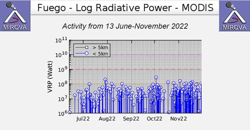 |
Figure 164. Frequent and strong thermal anomalies were detected at Fuego during July through November 2022, as shown in this MIROVA graph (Log Radiative Power). Both the power and frequency were relatively consistent during this period, with minor variations and a brief decrease in number during mid-October. Courtesy of MIROVA. |
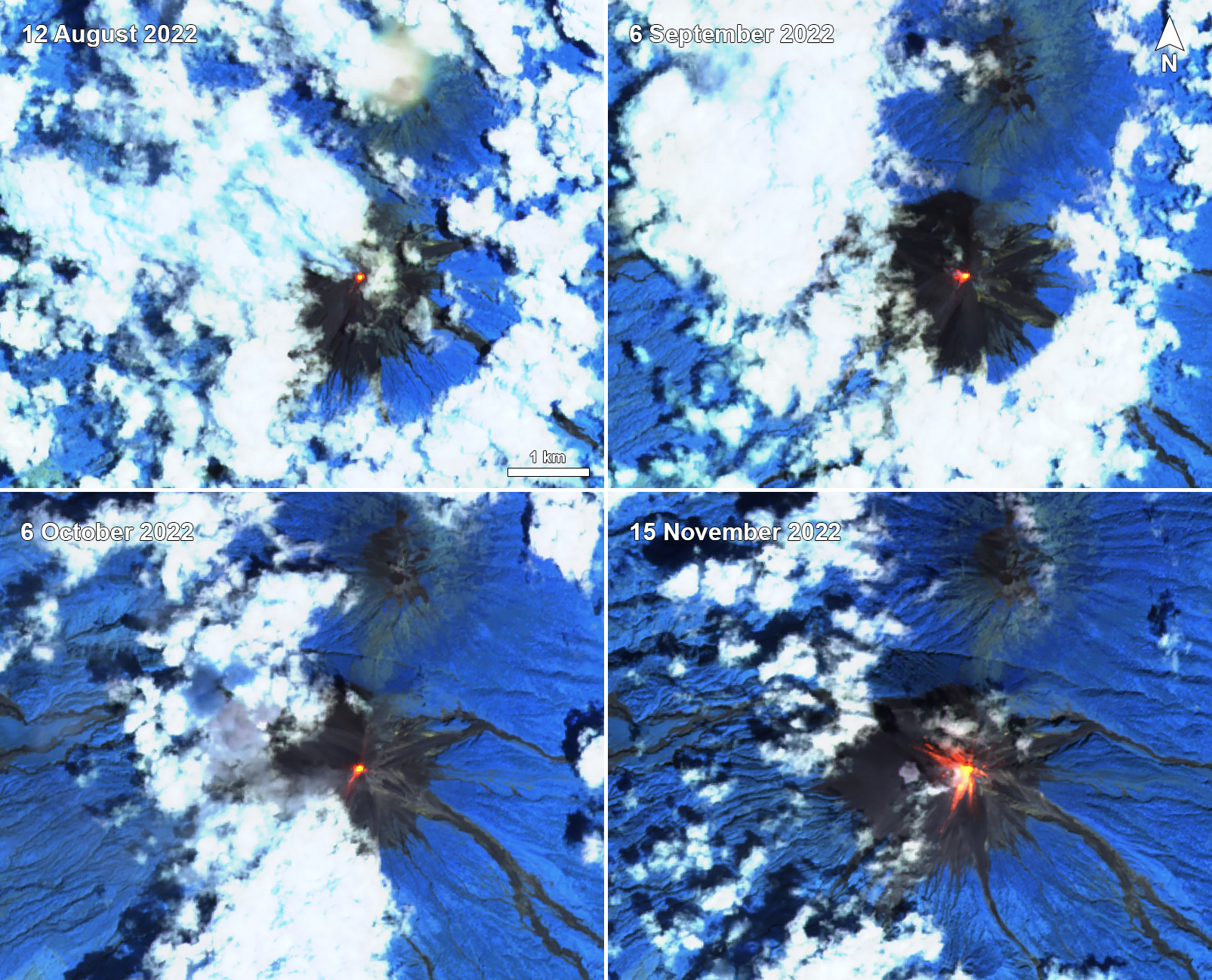 |
Figure 165. Sentinel-2 infrared satellite imagery showed frequent and strong thermal anomalies at the summit crater of Fuego on 12 August 2022 (top left), 6 September 2022 (top right), 6 October 2022 (bottom left), and 15 November 2022 (bottom right). Gray ash plumes and incandescent block avalanches were also occasionally visible; the ash plumes drifted W and avalanches of material descended multiple flanks, as shown on 6 October and 15 November. Images use “Atmospheric penetration” rendering (bands 12, 11, 8a). Courtesy of Sentinel Hub Playground. |
Daily explosions ranged between 2-12 per hour during August 2022, which generated ash plumes that rose to 4-4.9 km altitude and drifted 10-30 km W, SW, WSW, and NW. During the night and early morning incandescent pulses were observed typically 100-200 m above the crater. The explosions occasionally produced avalanches of material that varied in strength and descended in the direction of the Ceniza, Santa Teresa, Taniluyá, Trinidad, Las Lajas, Honda, and Seca drainages. As a result of the explosions, ashfall was frequently reported in the communities of Panimaché I and II (8 km SW), Morelia (9 km SW), Santa Sofía (12 km SW), Finca Palo Verde, El Porvenir (8 km ENE), Sangre de Cristo (8 km WSW), Yepocapa (8 km NW), Yucales (12 km SW), Ojo de Agua, and Acatenango. Possible fine ashfall was reported in Finca Ceilán, San Andrés Osuna, La Trinidad, and El Rodeo on 10 August. On 1 August a lava flow was observed in the Ceniza drainage, extending 1.3 km from the crater. During 5-6, 13-16, 25, and 31 August incandescent pulses rose 200-350 m above the crater accompanying the explosions and weak crater incandescence and degassing. During 12, 17, 24-25, and 29-30 August lahars were detected in the Ceniza drainage carrying hot volcanic material, tree branches and trunks, and blocks that ranged from 30 cm to 2 m in diameter. Lahars were also detected in the Las Lajas and El Jute drainages on 25 and 29-30 August that carried fine volcanic material, tree branches and trunks, and blocks that measured 30 cm to 1.5 m in diameter.
Daily explosions ranged from 3-15 per hour during September, which produced ash plumes that rose to 4.4-5 km altitude and drifted 10-30 km in multiple directions. Gray ashfall was reported over Panimaché I and II, Morelia, Santa Sofía, El Porvenir, Yucales, Finca Palo Verde, Sangre de Cristo, Yepocapa, Aldea La Cruz, Quisaché, La Rochela, and Finca la Asunción. The explosions also generated avalanches of varying intensities that traveled toward the Santa Teresa, Taniluyá, Ceniza, Las Lajas, Trinidad, Honda, and Seca drainages, some of which reached vegetation. Weak to strong rumbling sounds and shock waves vibrated the roofs and windows of homes in nearby communities. During most nights and early morning, incandescent pulses were visible up to 100-450 m above the crater; weak crater incandescence and degassing was also reported. Lahars were generated in the Las Lajas, El Jute, and Trinidad drainages on 2 September, carrying fine volcanic material, branches and tree trunks, and blocks that measured 30 cm to 1.5 m in diameter. On 5 September rain in the area generated lahars that descended the Las Lajas, El Jute, Ceniza, and Seca drainages. On 9 September fine ashfall was observed in Panimaché I, Morelia, Finca Asunción, La Rochela, El Zapote, El Rodeo, and Alotenango. On 11 and 13-14 September lahars were detected in the Las Lajas and El Jute drainages and on 12, 14, 27, and 29-30 September lahars were reported in the Ceniza drainage. On 16 September a lahar was reported in the Seca drainage that carried fine volcanic material, tree trunks and branches, and blocks measuring 30 cm to 1.5 m in diameter. Fine ashfall was also reported on 21 September in Panimaché I, Morelia, Finca Asunción, La Rochela, and Ceilán and in La Rochela, Ceilán, San Andrés Osuna, and Siquinala on 30 September.
During October daily explosions ranged from 4-12 per hour, producing gray ash plumes that rose to 4.2-4.9 km altitude and drifted 10-30 km S, SW, WSW, E, SE, SSW, W, and NW. Resulting ashfall was observed in Panimaché I and II, Morelia, Santa Sofía, Yucales, El Porvenir, Finca Palo Verde, Sangre de Cristo, Yepocapa, La Rochela, San Andrés Osuna, Finca Asunción, Ceilán, Ojo de Agua, El Zapote, and El Rodeo. Avalanches of material were generated from the explosions and descended the Santa Terea, Taniluyá, Ceniza, Trinidad, Las Lajas, Seca, Honda, and El Jute drainages, sometimes reaching the edge of vegetation. On 6, 24, and 30-31 October theses avalanches raised fine material 100-200 m above the surface that dispersed W, SW, WSW, and S. During the night and early morning, incandescent pulses were ejected 75-400 m above the crater during degassing periods. Lahars were generated in the Ceniza drainage during 1-2 and 24 October that carried blocks up to 1 m in diameter, fine sediment, and small tree trunks and branches and in the Seca drainage on 3-4 October. On 11 and 24 October lahars were reported in the Las Lajas and El Jute drainages. Lahars were observed in both the Ceniza and Trinidad drainages on 13 October.
Similar activity continued during November with daily explosions ranging from 4-15 per hour. Ash plumes rose to 4.3-4.8 km altitude and drifted 10-30 km in various directions. Avalanches of material descended the Ceniza, Seca, Santa Teresa, Taniluyá, Trinidad, El Jute, Las Lajas, and Honda drainages, sometimes reaching the edge of vegetation. Some of these avalanches uplifted fine material that rose 200 m above the surface and drifted S, SW, and W on 9, 14, 20, and 26 November. During the night and early morning, incandescent pulses rose 100-400 m above the crater. As a result of the explosions, fine ashfalls were reported in communities of Sangre de Cristo, Panimaché I and II, Morelia, Santa Sofía, El Porvenir, Yepocapa, Yucales, Finca Palo Verde, Finca Asunción, La Rochela, Ceilán, San Andrés Osuna, and El Rodeo. On 9 November lahars were observed in the Las Lajas and Ceniza drainage carrying fine volcanic material, tree trunks and branches, and blocks from 30 cm to 1.5 m in diameter.
Geological Summary. Volcán Fuego, one of Central America's most active volcanoes, is also one of three large stratovolcanoes overlooking Guatemala's former capital, Antigua. The scarp of an older edifice, Meseta, lies between Fuego and Acatenango to the north. Construction of Meseta dates back to about 230,000 years and continued until the late Pleistocene or early Holocene. Collapse of Meseta may have produced the massive Escuintla debris-avalanche deposit, which extends about 50 km onto the Pacific coastal plain. Growth of the modern Fuego volcano followed, continuing the southward migration of volcanism that began at the mostly andesitic Acatenango. Eruptions at Fuego have become more mafic with time, and most historical activity has produced basaltic rocks. Frequent vigorous historical eruptions have been recorded since the onset of the Spanish era in 1524, and have produced major ashfalls, along with occasional pyroclastic flows and lava flows.
Information Contacts: Instituto Nacional de Sismologia, Vulcanologia, Meteorologia e Hydrologia (INSIVUMEH), Unit of Volcanology, Geologic Department of Investigation and Services, 7a Av. 14-57, Zona 13, Guatemala City, Guatemala (URL: http://www.insivumeh.gob.gt/ ); MIROVA (Middle InfraRed Observation of Volcanic Activity), a collaborative project between the Universities of Turin and Florence (Italy) supported by the Centre for Volcanic Risk of the Italian Civil Protection Department (URL: http://www.mirovaweb.it/); Hawai'i Institute of Geophysics and Planetology (HIGP) - MODVOLC Thermal Alerts System, School of Ocean and Earth Science and Technology (SOEST), Univ. of Hawai'i, 2525 Correa Road, Honolulu, HI 96822, USA (URL: http://modis.higp.hawaii.edu/); Sentinel Hub Playground (URL: https://www.sentinel-hub.com/explore/sentinel-playground).