Report on Masaya (Nicaragua) — March 2023

Bulletin of the Global Volcanism Network, vol. 48, no. 3 (March 2023)
Managing Editor: Edward Venzke.
Edited by Kadie L. Bennis.
Masaya (Nicaragua) Thermal activity in the summit crater persisted during August 2022-January 2023
Please cite this report as:
Global Volcanism Program, 2023. Report on Masaya (Nicaragua) (Bennis, K.L., and Venzke, E., eds.). Bulletin of the Global Volcanism Network, 48:3. Smithsonian Institution.
Masaya
Nicaragua
11.9844°N, 86.1688°W; summit elev. 594 m
All times are local (unless otherwise noted)
Masaya is a broad, 6 x 11 km caldera with steep-sided walls up to 300 m high located about 20 km SE of Managua, the capital of Nicaragua. Eruptions have originated from the Nindirí and Masaya cones, which were constructed at the southern end of the fracture system and contain multiple summit craters, including the currently active Santiago crater. The Santiago crater contains a small lava lake that emits weak gas-and-steam plumes. The current eruption period began in October 2015 and more recently has consisted of weak thermal activity and gas-and-steam emissions (BGVN 47:08). This report updates activity from August 2022 through January 2023, characterized by continued thermal activity, seismicity, and sulfur dioxide emissions, based on Instituto Nicaragüense de Estudios Territoriales (INETER) monthly reports and satellite data.
Thermal activity has been relatively consistent over the past two years, according to the MIROVA (Middle InfraRed Observation of Volcanic Activity) graph (figure 107). An analysis of MODIS satellite data showed 15 low-power thermal hotspots during the reporting period: twice in mid-August 2022, twice in early November 2022, five times in December 2022, and six times in January 2023. Sentinel-2 infrared satellite images showed an occasional hotspot in the Santiago crater’s lava lake throughout the reporting period (figure 108). Intermittent small sulfur dioxide plumes drifted generally W on 16-17, 23, and 29 August, 2, 7-9, 18-19, 23, and 29 September, 4, 15, 21, 25-26, and 30 October, 1, 5-6, 10-12, and 26-27 November, and 29-30 January 2023, based on data from the TROPOMI instrument on the Sentinel-5P satellite.
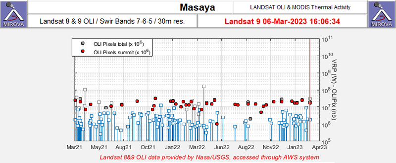 |
Figure 107. Consistent thermal anomalies (red dots) were detected at Masaya during March 2021 through January 2023, as recorded by the Landsat 8 and 9 satellite using OLI/SWIR bands 7, 6, 5. Courtesy of MIROVA. |
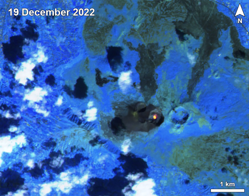 |
Figure 108. Sentinel-2 infrared satellite imagery showed a strong thermal anomaly (bright yellow-orange) at the active lava lake in Masaya’s Santiago crater throughout the entire reporting period of August 2022 through January 2023; a typical example is shown here on 19 December 2022. Images with "Atmospheric penetration" (bands 12, 11, 8A) rendering. Courtesy of Sentinel Hub Playground. |
Activity was relatively low throughout the reporting period. Gas measurements were made with a Mobile DOAS during August, showing average sulfur dioxide values of 746 metric tons/day (t/d) and 694 t/d on 23 and 28 August, respectively. Seismic tremor was at 80 RSAM units and 239 low-frequency (LF) seismic events were recorded during August. On 12 August temperature measurements were taken in the lava lake of the Santiago crater, recording values of 300°C. This temperature was lower compared to the previous month. During September the average value of sulfur dioxide emissions was 551 t/d on 8 September. On 9 September temperature measurements were recorded at 294 °C and INETER reported that the level of the lava lake had decreased.
During October and November, the seismic amplitude remained at 50 units. There were 175 LF events and two tectonic earthquakes detected in October and three LF events in November. On 7 October INETER recorded a lava lake temperature of 310°C and reported that the lake level had decreased since measurements were taken in September. There was an increase in sulfur dioxide emissions that had a value of 1,334 t/d on 24 October. Similar activity continued during December and January 2023. The seismic amplitude varied between 50 and 100 units, with two LF events recorded in December and two tectonic earthquakes recorded in January.
Geological Summary. Masaya volcano in Nicaragua has erupted frequently since the time of the Spanish Conquistadors, when an active lava lake prompted attempts to extract the volcano's molten "gold" until it was found to be basalt rock upon cooling. It lies within the massive Pleistocene Las Sierras caldera and is itself a broad, 6 x 11 km basaltic caldera with steep-sided walls up to 300 m high. The caldera is filled on its NW end by more than a dozen vents that erupted along a circular, 4-km-diameter fracture system. The Nindirí and Masaya cones, the source of observed eruptions, were constructed at the southern end of the fracture system and contain multiple summit craters, including the currently active Santiago crater. A major basaltic Plinian tephra erupted from Masaya about 6,500 years ago. Recent lava flows cover much of the caldera floor and there is a lake at the far eastern end. A lava flow from the 1670 eruption overtopped the north caldera rim. Periods of long-term vigorous gas emission at roughly quarter-century intervals have caused health hazards and crop damage.
Information Contacts: Instituto Nicaragüense de Estudios Territoriales (INETER), Apartado Postal 2110, Managua, Nicaragua (URL: http://www.ineter.gob.ni/); MIROVA (Middle InfraRed Observation of Volcanic Activity), a collaborative project between the Universities of Turin and Florence (Italy) supported by the Centre for Volcanic Risk of the Italian Civil Protection Department (URL: http://www.mirovaweb.it/); NASA Global Sulfur Dioxide Monitoring Page, Atmospheric Chemistry and Dynamics Laboratory, NASA Goddard Space Flight Center (NASA/GSFC), 8800 Greenbelt Road, Goddard, Maryland, USA (URL: https://so2.gsfc.nasa.gov/); Sentinel Hub Playground (URL: https://www.sentinel-hub.com/explore/sentinel-playground).