Report on Nyiragongo (DR Congo) — April 2023

Bulletin of the Global Volcanism Network, vol. 48, no. 4 (April 2023)
Managing Editor: Edward Venzke.
Research and preparation by Paul Berger.
Nyiragongo (DR Congo) Ongoing lava lake activity in the summit crater through March 2023
Please cite this report as:
Global Volcanism Program, 2023. Report on Nyiragongo (DR Congo) (Venzke, E., ed.). Bulletin of the Global Volcanism Network, 48:4. Smithsonian Institution.
Nyiragongo
DR Congo
1.52°S, 29.25°E; summit elev. 3470 m
All times are local (unless otherwise noted)
Nyiragongo, in the Democratic Republic of the Congo, is part of the Virunga Volcanic Province along the western branch of the East African Rift System near the Rwanda border. It contains a 1.2-km-wide summit crater with a lava lake that has been active since at least 1971. Eruptions during the last 120 years have been associated within the summit crater; several flank lava flows have also been observed, sometimes reaching and causing destruction in the city of Goma (15 km S) (BGVN 27:04, 42:01, 46:06). The current report summarizes data between July 2022 and March 2023 and is based on information from the Observatoire Volcanologique de Goma (OVG) and satellite data.
The MIROVA (Middle InfraRed Observation of Volcanic Activity) system recorded numerous hotspots during June-July 2022 (figure 94), with additional stronger activity detected in mid-October, December, and February-March 2023 (figure 95). Thermal anomaly data from Sentinel-2 for the previous two years (figure 96) shows the intermittent lava activity in the summit crater since the lava flows from S-flank fissures reached Goma in late May 2021 (BGVN 46:06). According to OVG, several earthquakes along the fault between the summit and Shaheru (~2 km S) craters occurred on 9 October, and strong incandescence at night was seen above the crater on 11 October. High concentrations of carbon dioxide were measured by OVG in some areas near the volcano during mid-February 2023 and residents were warned to stay away from those areas.
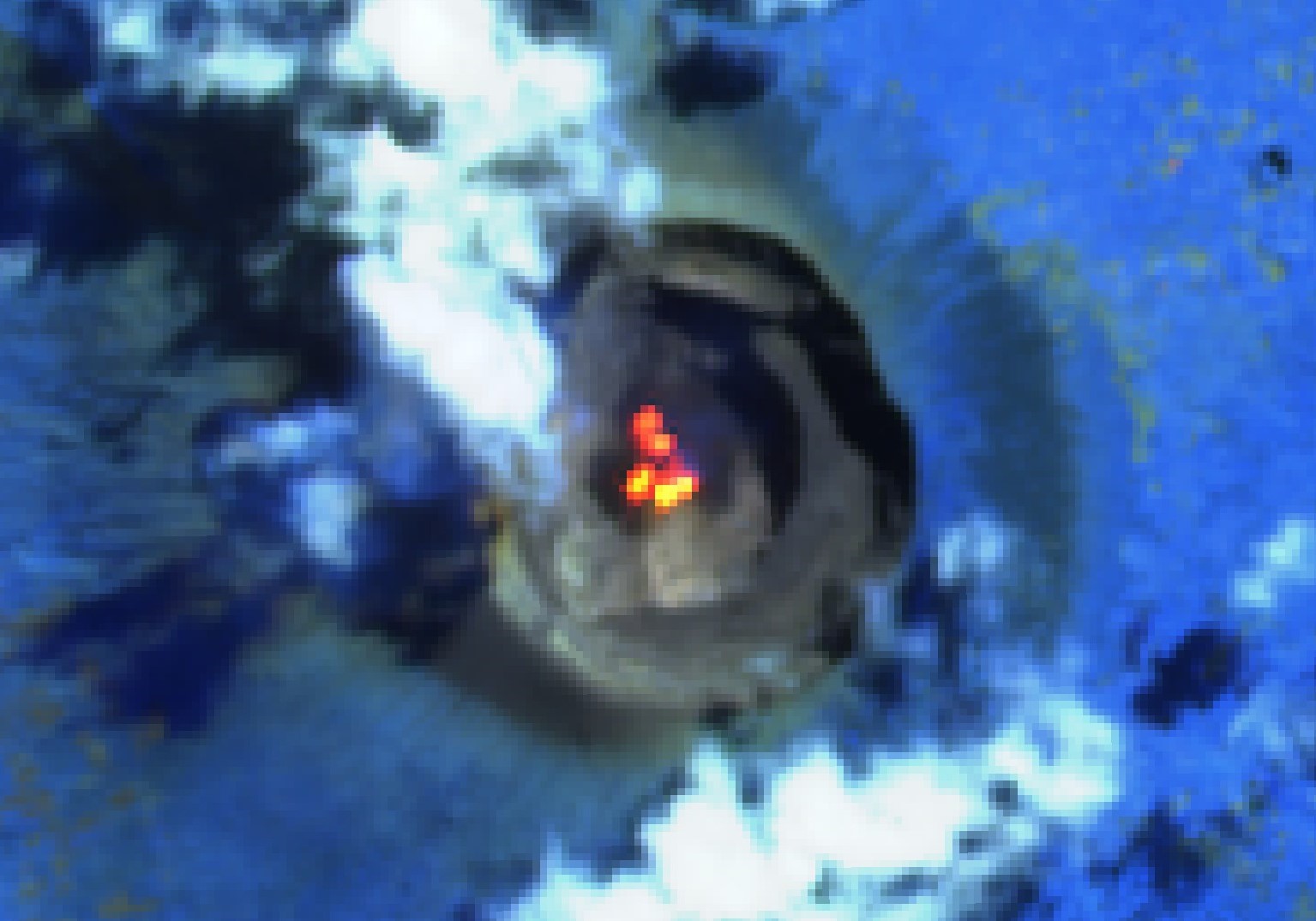 |
Figure 94. Sentinel-2 infrared satellite imagery from 21 July 2022 showed multiple hotspots within the Nyiragongo summit crater. Image used “Atmospheric penetration” rendering (bands 12, 11, 8a). Courtesy of Sentinel Hub Playground. |
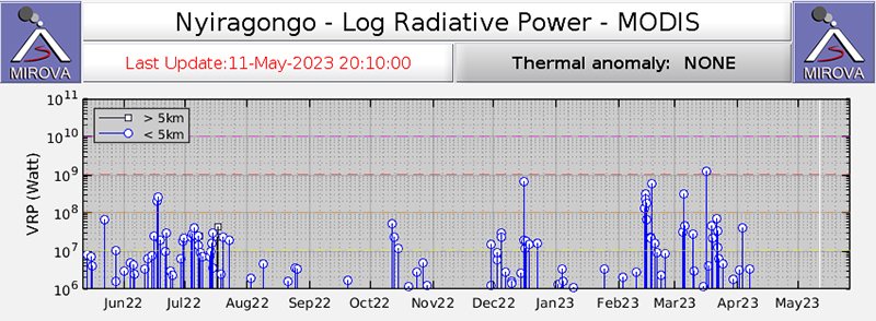 |
Figure 95. MIROVA graph of thermal activity in the summit crater for the year beginning on 10 May 2022. Frequent strong thermal anomalies were prevalent in July and December 2022, and again during February-March 2023. Courtesy of MIROVA. |
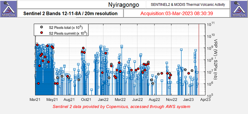 |
Figure 96. Infrared satellite data from Sentinel-2, as shown on this MIROVA graph, shows thermal anomalies at Nyiragongo for the two years prior to 3 March 2023. Activity has been intermittent in the summit crater since late May 2021 when there were lava flows from S-flank fissures. Courtesy of MIROVA. |
Geological Summary. The Nyiragongo stratovolcano contained a lava lake in its deep summit crater that was active for half a century before draining catastrophically through its outer flanks in 1977. The steep slopes contrast to the low profile of its neighboring shield volcano, Nyamuragira. Benches in the steep-walled, 1.2-km-wide summit crater mark levels of former lava lakes, which have been observed since the late-19th century. Two older stratovolcanoes, Baruta and Shaheru, are partially overlapped by Nyiragongo on the north and south. About 100 cones are located primarily along radial fissures south of Shaheru, east of the summit, and along a NE-SW zone extending as far as Lake Kivu. Many cones are buried by voluminous lava flows that extend long distances down the flanks, which is characterized by the eruption of foiditic rocks. The extremely fluid 1977 lava flows caused many fatalities, as did lava flows that inundated portions of the major city of Goma in January 2002.
Information Contacts: Observatoire Volcanologique de Goma (OVG), Departement de Geophysique, Centre de Recherche en Sciences Naturelles, Lwiro, D.S. Bukavu, DR Congo; MIROVA (Middle InfraRed Observation of Volcanic Activity), a collaborative project between the Universities of Turin and Florence (Italy) supported by the Centre for Volcanic Risk of the Italian Civil Protection Department (URL: http://www.mirovaweb.it/); Sentinel Hub Playground (URL: https://www.sentinel-hub.com/explore/sentinel-playground).