Report on Langila (Papua New Guinea) — April 2023

Bulletin of the Global Volcanism Network, vol. 48, no. 4 (April 2023)
Managing Editor: Edward Venzke.
Research and preparation by Paul Berger.
Langila (Papua New Guinea) Thermal anomalies during clear weather through March 2023; ash plume on 20 October 2022
Please cite this report as:
Global Volcanism Program, 2023. Report on Langila (Papua New Guinea) (Venzke, E., ed.). Bulletin of the Global Volcanism Network, 48:4. Smithsonian Institution.
Langila
Papua New Guinea
5.525°S, 148.42°E; summit elev. 1330 m
All times are local (unless otherwise noted)
Frequent weak-to-moderate ash explosions and lava flows have been recorded since the 19th century from three active craters at the summit of Langila, located on Papua New Guinea’s New Britain Island. The current eruption period began in October 2015; recent activity has included low-level thermal activity, ash emissions, and SO2 plumes (BGVN 47:10). Similar low-level activity continued during October 2022-March 2023 based on information from the Darwin Volcanic Ash Advisory Center (VAAC) and satellite images.
The only completely clear Sentinel-2 image during the reporting period showed a single bright hotspot at the SE crater on 20 October, and thermal anomalies were visible on 4 and 7 November in two craters (figure 31). Persistent clouds prevented observations until another anomaly in one crater was visible starting on 28 January and on other clear days through March 2023. Gas-and-steam emissions rising from the crater were also sometimes present. The MIROVA hotspot detection system also recorded only a few scattered thermal anomalies during October 2022-March 2023 (figure 32), which cloud cover was common. The MODIS-MODVOLC thermal detection system did not record any hotspots during this time.
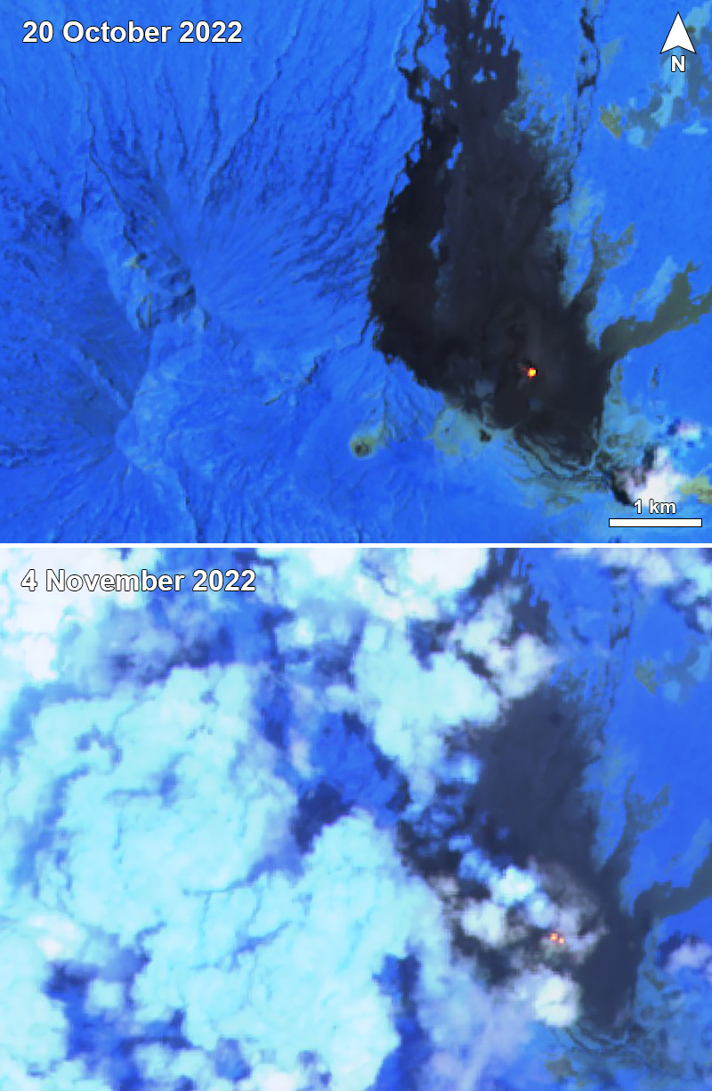 |
Figure 31. Sentinel-2 infrared satellite images of Langila showed a persistent hotspot in the SE crater and occasional wispy gas-and-steam emissions during October 2022-March 2023. A thermal anomaly is seen here from one crater on 20 October (top) and two craters on 4 November 2022 (bottom). Sentinel-2 satellite images with “Atmospheric penetration” (bands 12, 11, 8A) rendering. Courtesy of Sentinel Hub Playground. |
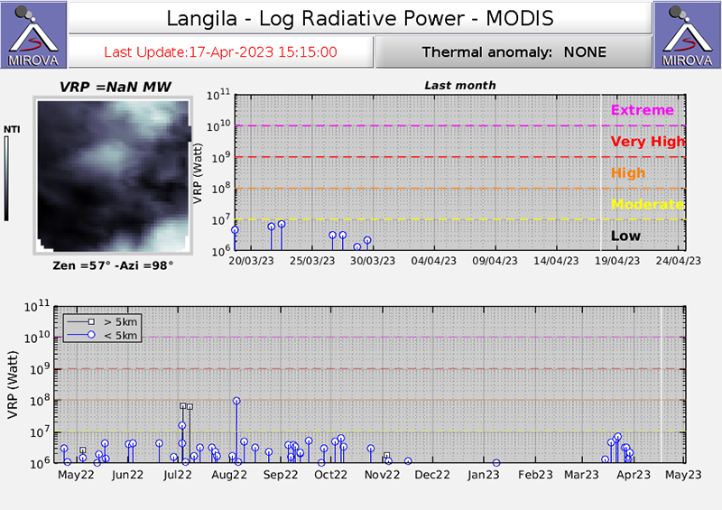 |
Figure 32. The MIROVA hotspot detection system (Middle InfraRed Observation of Volcanic Activity) graph showed intermittent low-power MODIS thermal anomalies at Langila into mid-November 2022, one in early January 2023, and then more frequent detections in the second half of March 2023. Courtesy of MIROVA. |
A single strong SO2 plume was observed by the TROPOMI instrument aboard the Sentinel-5P satellite during the reporting period, on 26 October 2022. According to the Darwin VAAC, an ash plume rose 2.7 km in altitude, or 1.4 km above the summit, on 20 October and drifted NW. The plume dissipated within five hours.
Geological Summary. Langila, one of the most active volcanoes of New Britain, consists of a group of four small overlapping composite basaltic-andesitic cones on the lower E flank of the extinct Talawe volcano in the Cape Gloucester area of NW New Britain. A rectangular, 2.5-km-long crater is breached widely to the SE; Langila was constructed NE of the breached crater of Talawe. An extensive lava field reaches the coast on the N and NE sides of Langila. Frequent mild-to-moderate explosive eruptions, sometimes accompanied by lava flows, have been recorded since the 19th century from three active craters at the summit. The youngest and smallest crater (no. 3 crater) was formed in 1960 and has a diameter of 150 m.
Information Contacts: Sentinel Hub Playground (URL: https://www.sentinel-hub.com/explore/sentinel-playground); MIROVA (Middle InfraRed Observation of Volcanic Activity), a collaborative project between the Universities of Turin and Florence (Italy) supported by the Centre for Volcanic Risk of the Italian Civil Protection Department (URL: http://www.mirovaweb.it/); Darwin Volcanic Ash Advisory Centre (VAAC), Bureau of Meteorology, Northern Territory Regional Office, PO Box 40050, Casuarina, NT 0811, Australia (URL: http://www.bom.gov.au/info/vaac/); NASA Global Sulfur Dioxide Monitoring Page, Atmospheric Chemistry and Dynamics Laboratory, NASA Goddard Space Flight Center (NASA/GSFC), 8800 Greenbelt Road, Goddard, Maryland, USA (URL: https://so2.gsfc.nasa.gov/).