Report on Popocatepetl (Mexico) — April 2023

Bulletin of the Global Volcanism Network, vol. 48, no. 4 (April 2023)
Managing Editor: Edward Venzke.
Edited by Kadie L. Bennis.
Popocatepetl (Mexico) Daily gas-and-ash emissions, explosions, and ashfall during December 2022-March 2023
Please cite this report as:
Global Volcanism Program, 2023. Report on Popocatepetl (Mexico) (Bennis, K.L., and Venzke, E., eds.). Bulletin of the Global Volcanism Network, 48:4. Smithsonian Institution.
Popocatepetl
Mexico
19.023°N, 98.622°W; summit elev. 5393 m
All times are local (unless otherwise noted)
Popocatépetl, located 70 km SE of Mexico City, Mexico, contains a 400 x 600 m-wide summit crater. Records of activity date back to the 14th century; three major Plinian eruptions, the most recent of which took place about 800 CE, have occurred since the mid-Holocene, accompanied by pyroclastic flows and voluminous lahars that swept basins below the volcano. The current eruption period began in January 2005, characterized by numerous episodes of lava dome growth and destruction within the summit caldera. More recently, activity has consisted of daily gas-and-ash plumes, intermittent explosions, and ashfall (BGVN 47:12). This report covers activity during December 2022 through March 2023, characterized by daily gas-and-ash emissions, explosions, and ashfall events, according to daily reports from México's Centro Nacional de Prevención de Desastres (CENAPRED) and various satellite data.
Daily gas-and-steam emissions, containing some amount of ash, persisted during December 2022 through March 2023. CENAPRED reported the number of low-intensity gas-and-ash emissions or “exhalations” and the minutes of tremor, which sometimes included harmonic tremor in their daily reports (figure 205). A total of 41 volcano-tectonic (VT) tremors were detected throughout the reporting period. The average number of exhalations was 150 per day, with a maximum number of 317 on 5 February 2023. Frequent sulfur dioxide plumes that exceeded two Dobson Units (DU) were visible in satellite data from the TROPOMI instrument on the Sentinel-5P satellite (figure 206).
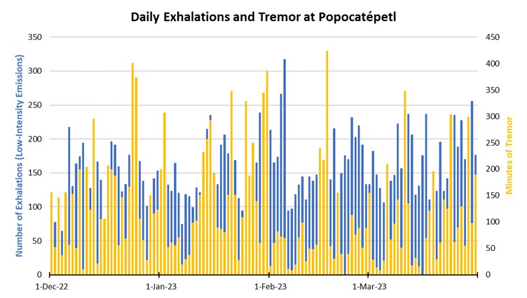 |
Figure 205. Graph showing the number of daily “exhalations” (in blue, left scale), and the number of minutes of tremor (in gold, right scale) at Popocatépetl each day during December 2022 through March 2023. The maximum number of daily exhalations was 317 on 5 February 2023; the maximum duration of 423 minutes of tremor was detected on 17 February 2023. Data from CENAPRED daily reports. |
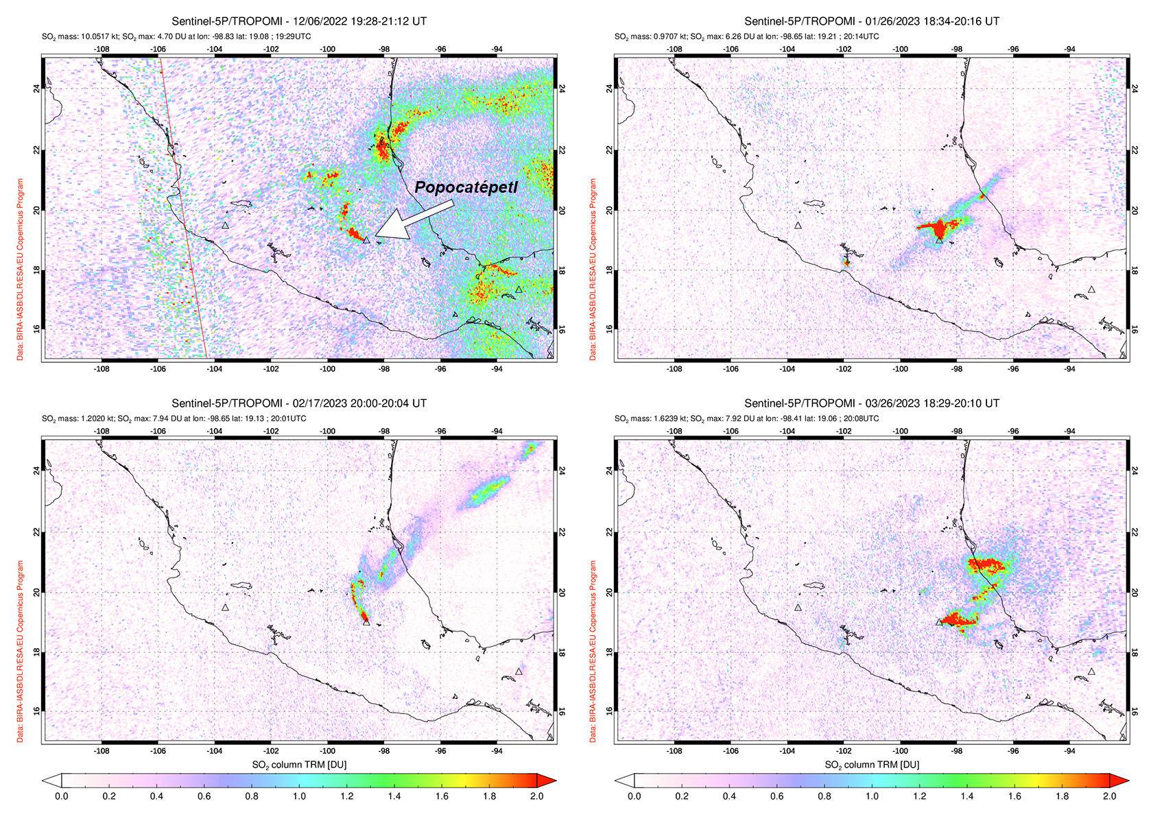 |
Figure 206. Sulfur dioxide plumes were detected at Popocatépetl and drifted in different directions on 6 December 2022 (top left), 26 January 2023 (top right), 17 February 2023 (bottom left), and 26 March 2023 (bottom right). Courtesy of NASA Global Sulfur Dioxide Monitoring Page. |
Activity during December mostly consisted of daily gas-and-steam and ash emissions, with 34 explosions and 11 VT-type events detected. An average of 130 exhalations occurred each day, which mostly consisted of water vapor, volcanic gases, and a small amount of ash (figure 207). The National Center for Communications and Civil Protection Operations (CENACOM) reported light-to-moderate ashfall in Amecameca, Cocotitlán, and Tlalmanalco on 2 December and in Tepetlixpa on 3 December. Light ashfall was reported in Atlautla, and Ozumba on 6 December. A minor explosion at 0258 on 7 December was accompanied by light ashfall in Atlautla, Ayapango, Tenango, Tepetlixpa, Temamatla, Tlalmanalco, Ecatzingo, and Ozumba. On 8 December light ashfall was observed in Amecameca, Temamatla, Ecatzingo, Tenango del Aire, and Ozumba. As many as 30 minor explosions were intermittently detected throughout the month, and there were only three moderate explosions recorded, according to data from CENAPRED.
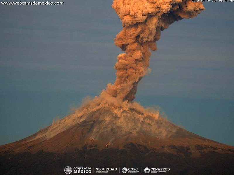 |
Figure 207. Webcam image of an ash plume rising above the summit of Popocatépetl on 19 December 2022. Photo has been color corrected. Courtesy of CENAPRED daily report. |
Similar activity continued during January 2023 with an average of 140 exhalations each day, 16 VT-type events, and 59 explosions. There were 51 minor explosions and nine moderate explosions recorded throughout the month. An explosion was recorded at 0552 on 6 January, which resulted in light ashfall in Tetela del Volcán. CENACOM reported light ashfall in Tianguismanalco, Juan C. Bonilla, and Atlixco on 12 January and in Domingo Arenas, San Nicolas de los Ranchos, Santiago and Xalizintla, in the town of San Mateo Ozolco in Calpan, and in Tlaxcala and Papalotla on 17 January. On 21 January a minor explosion generated an ash plume that rose 3 km above the crater and drifted NNE (figure 208). During the morning of 25 January light ashfall was reported in San Nicolás de los Ranchos. An overflight carried out on 27 January noted that the inner crater rim dimensions was approximately 390-410 m in diameter, which suggested that there were no significant changes since February 2022. A small dome was visible, approximately 30-40 m in diameter and with a height of 5-10 m. There were also two gas emission zones observed on the floor of the inner crater. During the morning of 30 January light ashfall was reported in Amecameca, Temamatla, and Tenango Air. Three minor explosions were detected at 0533, 0619, and 0721 on 31 January, and a moderate explosion at 0029 produced an ash plume that rose 1.8 km above the summit and ejected incandescent material as far as 2 km from the crater rim (figure 209).
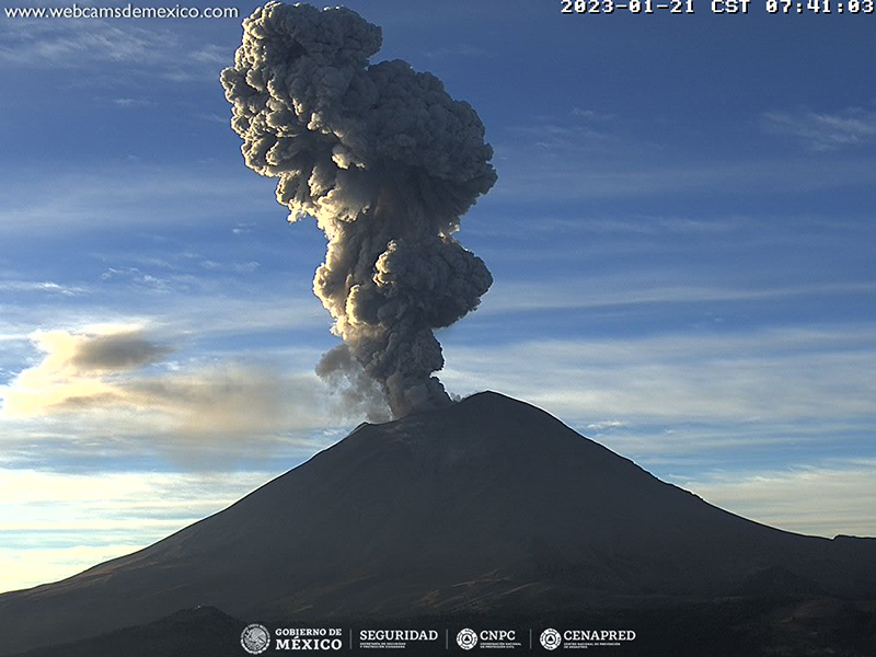 |
Figure 208. Webcam image showing a strong ash plume that rose 3 km above the summit of Popocatépetl and drifted NNE on 21 January 2023. Courtesy of CENAPRED daily report. |
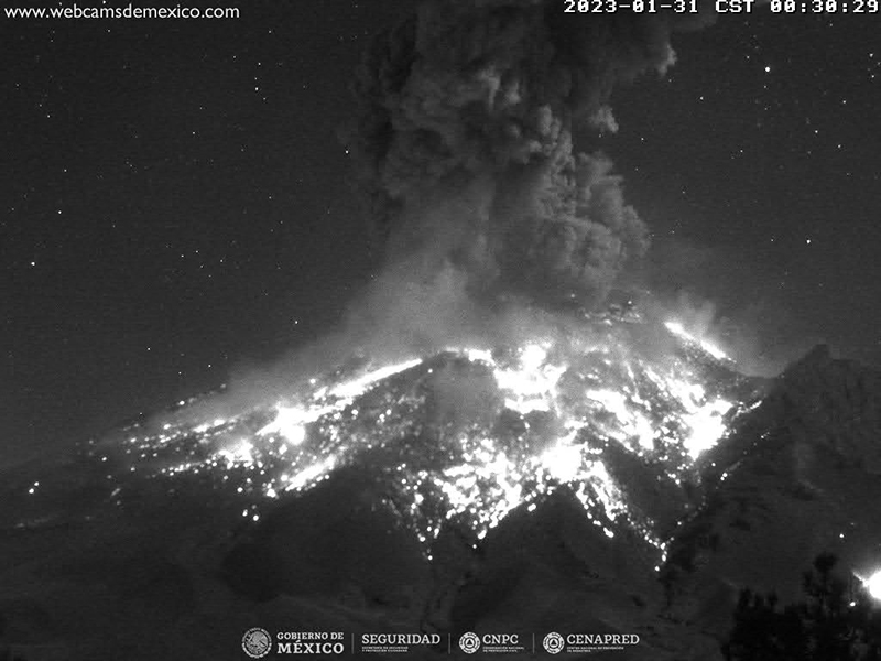 |
Figure 209. Webcam image showing a strong ash plume that rose 1.8 km above the summit of Popocatépetl and ejected incandescent material as far as 2 km from the crater rim on 31 January 2023. Courtesy of CENAPRED daily report. |
During February, activity continued with an average of 162 exhalations each day, 6 VT-type events, and 95 explosions. There were 86 minor explosions and 9 moderate explosions reported throughout the month. Light ashfall was noted on 2 February in Tepetlixpa, Amecameca, Ecatzingo, Ozumba, Tetela del Volcán, and Morelos.
An average of 168 exhalations were reported each day during March, consisting of gas-and-steam and ash emissions. Seismicity was characterized by 8 VT-type events and 99 explosions were recorded. There were 65 minor explosions and 24 moderate explosions recorded during the month (figure 210). On 8 March a minor explosion was recorded at 0401, and light ashfall was observed during the night and early morning in Tetela del Volcán and San Pedro Benito Juárez. During the early morning of 9 March light ashfall was reported in Tetela del Volcán, Morelos. Light ashfall was reported in San Nicolás de los Ranchos on 24 March, in San Andrés Cholula and Cuautlancingo, Puebla on 25 March, and in San Andrés Cholula, Cuautlancingo, Puebla on 26 March, and in Tepetlixpa, Amecameca, Ayapango, and Cocotitlán on 28 March.
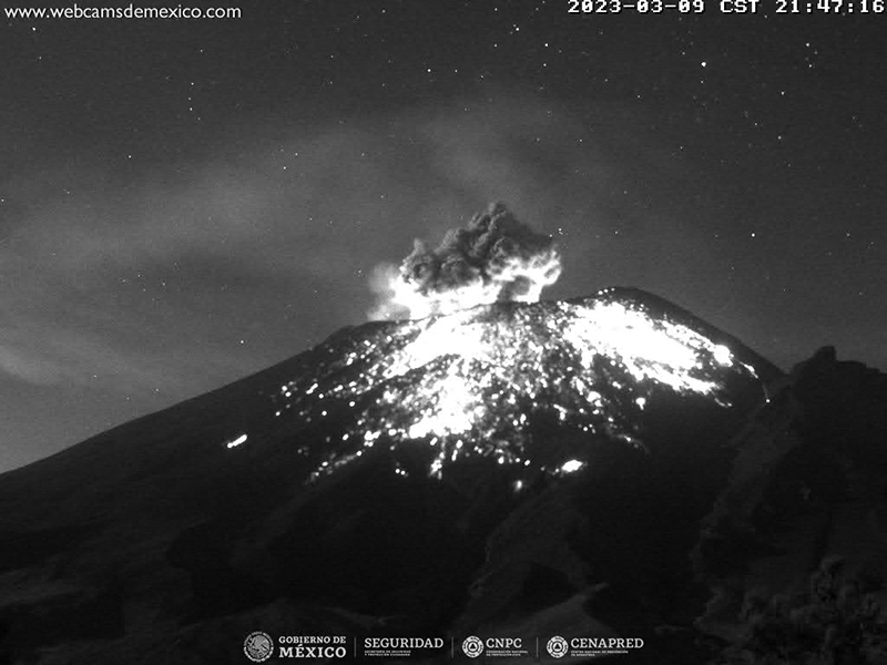 |
Figure 210. Webcam image showing an ash plume rising above the summit of Popocatépetl, accompanied by incandescent ejecta on the flanks on 9 March 2023 Courtesy of CENAPRED daily report. |
MODIS thermal anomaly data provided through MIROVA (Middle InfraRed Observation of Volcanic Activity) showed consistent, moderate thermal anomalies during the reporting period (figure 211). According to data from MODVOLC thermal alerts, a total of 42 hotspots were detected at the summit crater in December 2022 (6, 8, 15, and 17), January 2023 (10, 16, 21, 22, 27, 28, and 30), February (3, 5, 11, 12, 15, 17, 18 and 22), and March (1, 4, 7, 11, 20, 22, 23, 27, 29, and 30). Some of these hotspots were also visible in the summit crater in infrared satellite data from Sentinel-2 that were sometimes accompanied by gas-and-steam or ash plumes, as shown on 1 January 2023 (figure 212).
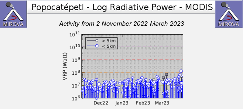 |
Figure 211. The MIROVA graph of frequent thermal anomalies at Popocatépetl from 2 November 2022 through March 2023 showing moderate and consistent thermal activity. Courtesy of MIROVA. |
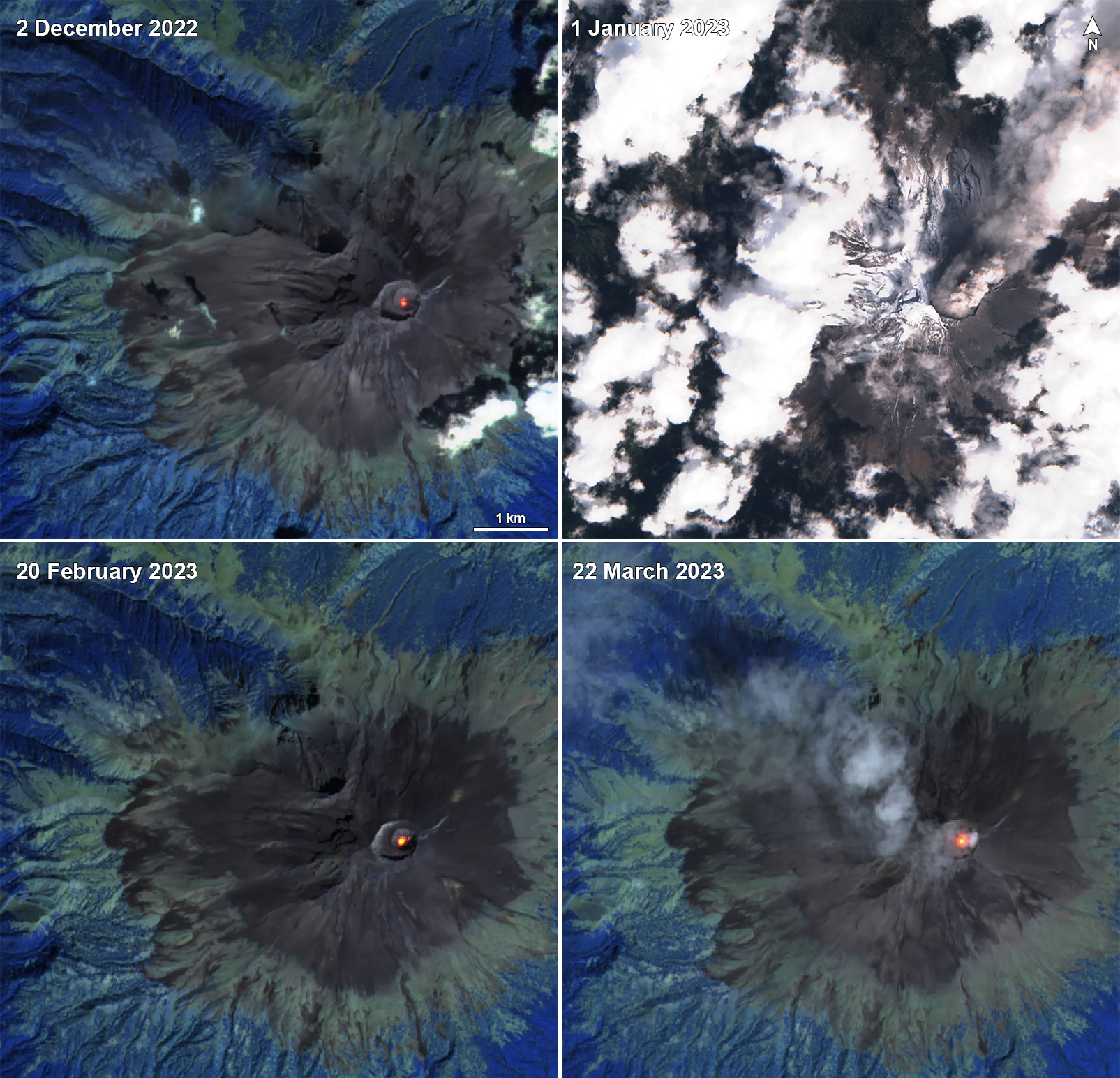 |
Figure 212. Sentinel-2 infrared satellite images showing a persistent thermal anomaly in the summit crater of Popocatépetl on 2 December 2022 (top left), 20 February 2023 (bottom left), and 22 March 2023 (bottom right). A strong ash plume was captured in a Natural Color satellite image on 1 January 2023 (top right). Infrared images taken with “Atmospheric penetration” rendering (bands 12, 11, 8A) and “Natural color” rendering (bands 4, 3, 2). Courtesy of Sentinel Hub Playground. |
Geological Summary. Volcán Popocatépetl, whose name is the Aztec word for smoking mountain, rises 70 km SE of Mexico City to form North America's 2nd-highest volcano. The glacier-clad stratovolcano contains a steep-walled, 400 x 600 m wide crater. The generally symmetrical volcano is modified by the sharp-peaked Ventorrillo on the NW, a remnant of an earlier volcano. At least three previous major cones were destroyed by gravitational failure during the Pleistocene, producing massive debris-avalanche deposits covering broad areas to the south. The modern volcano was constructed south of the late-Pleistocene to Holocene El Fraile cone. Three major Plinian eruptions, the most recent of which took place about 800 CE, have occurred since the mid-Holocene, accompanied by pyroclastic flows and voluminous lahars that swept basins below the volcano. Frequent historical eruptions, first recorded in Aztec codices, have occurred since Pre-Columbian time.
Information Contacts: Centro Nacional de Prevención de Desastres (CENAPRED), Av. Delfín Madrigal No.665. Coyoacan, México D.F. 04360, México (URL: http://www.cenapred.unam.mx/, Daily Report Archive https://www.gob.mx/cenapred/archivo/articulos); MIROVA (Middle InfraRed Observation of Volcanic Activity), a collaborative project between the Universities of Turin and Florence (Italy) supported by the Centre for Volcanic Risk of the Italian Civil Protection Department (URL: http://www.mirovaweb.it/); Hawai'i Institute of Geophysics and Planetology (HIGP) - MODVOLC Thermal Alerts System, School of Ocean and Earth Science and Technology (SOEST), Univ. of Hawai'i, 2525 Correa Road, Honolulu, HI 96822, USA (URL: http://modis.higp.hawaii.edu/); NASA Global Sulfur Dioxide Monitoring Page, Atmospheric Chemistry and Dynamics Laboratory, NASA Goddard Space Flight Center (NASA/GSFC), 8800 Greenbelt Road, Goddard, Maryland, USA (URL: https://so2.gsfc.nasa.gov/); Sentinel Hub Playground (URL: https://www.sentinel-hub.com/explore/sentinel-playground).