Report on Fuego (Guatemala) — April 2023

Bulletin of the Global Volcanism Network, vol. 48, no. 4 (April 2023)
Managing Editor: Edward Venzke.
Edited by Kadie L. Bennis.
Fuego (Guatemala) Daily explosions, gas-and-ash plumes, avalanches, and ashfall during December 2022-March 2023
Please cite this report as:
Global Volcanism Program, 2023. Report on Fuego (Guatemala) (Bennis, K.L., and Venzke, E., eds.). Bulletin of the Global Volcanism Network, 48:4. Smithsonian Institution.
Fuego
Guatemala
14.473°N, 90.88°W; summit elev. 3763 m
All times are local (unless otherwise noted)
Fuego, one of three large stratovolcanoes overlooking the city of Antigua, Guatemala, has been vigorously erupting since January 2002, with recorded eruptions dating back to 1531 CE. Eruptive activity has included major ashfalls, pyroclastic flows, lava flows, and lahars. Frequent explosions with ash emissions, block avalanches, and lava flows have persisted since 2018. More recently, activity remained relatively consistent with daily explosions, ash plumes, ashfall, avalanches, and lahars (BGVN 48:03). This report covers similar activity during December 2022 through March 2023, based on information from the Instituto Nacional de Sismologia, Vulcanología, Meteorología e Hidrologia (INSIVUMEH) daily reports, Coordinadora Nacional para la Reducción de Desastres (CONRED) newsletters, and various satellite data.
Daily explosions reported throughout December 2022-March 2023 generated ash plumes to 6 km altitude that drifted as far as 60 km in multiple directions. The explosions also caused rumbling sounds of varying intensities, with shock waves that vibrated the roofs and windows of homes near the volcano. Incandescent pulses of material rose 100-500 m above the crater, which caused block avalanches around the crater and toward the Santa Teresa, Taniluyá (SW), Ceniza (SSW), El Jute, Honda, Las Lajas (SE), Seca (W), and Trinidad (S) drainages. Fine ashfall was also frequently reported in nearby communities (table 27). MIROVA (Middle InfraRed Observation of Volcanic Activity) analysis of MODIS satellite data showed frequent, moderate thermal activity throughout the reporting period; however, there was a brief decline in both power and frequency during late-to-mid-January 2023 (figure 166). A total of 79 MODVOLC thermal alerts were issued: 16 during December 2022, 17 during January 2023, 23 during February, and 23 during March. Some of these thermal evets were also visible in Sentinel-2 infrared satellite imagery at the summit crater, which also showed occasional incandescent block avalanches descending the S, W, and NW flanks, and accompanying ash plumes that drifted W (figure 167).
Table 27. Activity at Fuego during December 2022 through March 2023 included multiple explosions every hour. Ash emissions rose as high as 6 km altitude and drifted generally W and SW as far as 60 km, causing ashfall in many communities around the volcano. Data from daily INSIVUMEH reports and CONRED newsletters.
| Month | Explosions per hour | Ash plume altitude (max) | Ash plume distance (km) and direction | Drainages affected by block avalanches | Communities reporting ashfall |
| Dec 2022 | 1-12 | 6 km | WSW, W, SW, NW, S, SE, NE, and E, 10-30 km | Santa Teresa, Taniluyá, Ceniza, El Jute, Honda, Las Lajas, Seca, and Trinidad | Panimaché I and II, Morelia, Santa Sofía, El Porvenir, Finca Palo Verde, Yepocapa, Yucales, Sangre de Cristo, La Rochela, Ceilán, San Andrés Osuna, and Aldea La Cruz |
| Jan 2023 | 1-12 | 5 km | W, SW, NW, S, N, NE, E, and SE, 7-60 km | Ceniza, Las Lajas, Santa Teresa, Taniluyá, Trinidad, Seca, Honda, and El Jute | Panimaché I and II, Morelia, Santa Sofía, El Porvenir, Palo Verde, Yucales, Yepocapa, Sangre de Cristo, La Rochela, Ceylon, Alotenango, and San Andrés Osuna |
| Feb 2023 | 1-12 | 4.9 km | SW, W, NW, and N, 10-30 km | Santa Teresa, Taniluyá, Ceniza, Las Lajas, Seca, Trinidad, El Jute, and Honda | Panimaché I and II, Morelia, Santa Sofía, Palo Verde, San Pedro Yepocapa, El Porvenir, Sangre de Cristo, La Soledad, Acatenango, El Campamento, and La Asunción |
| Mar 2023 | 3-11 | 5 km | W, SW, NW, NE, N, S, SE, and E, 10-30 km | Seca, Ceniza, Taniluyá, Las Lajas, Honda, Trinidad, El Jute, and Santa Teresa | Yepocapa, Sangre de Cristo, Panimaché I and II, Morelia, Santa Sofía, El Porvenir, La Asunción, Palo Verde, La Rochela, San Andrés Osuna, Ceilán, and Aldeas |
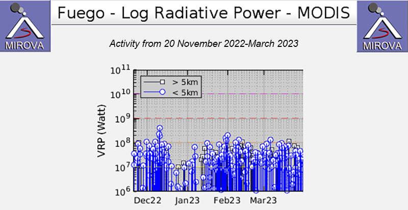 |
Figure 166. Thermal activity at Fuego shown in the MIROVA graph (Log Radiative Power) was at moderate levels during a majority of December 2022 through March 2023, with a brief decline in both power and frequency during late-to-mid-January 2023. Courtesy of MIROVA. |
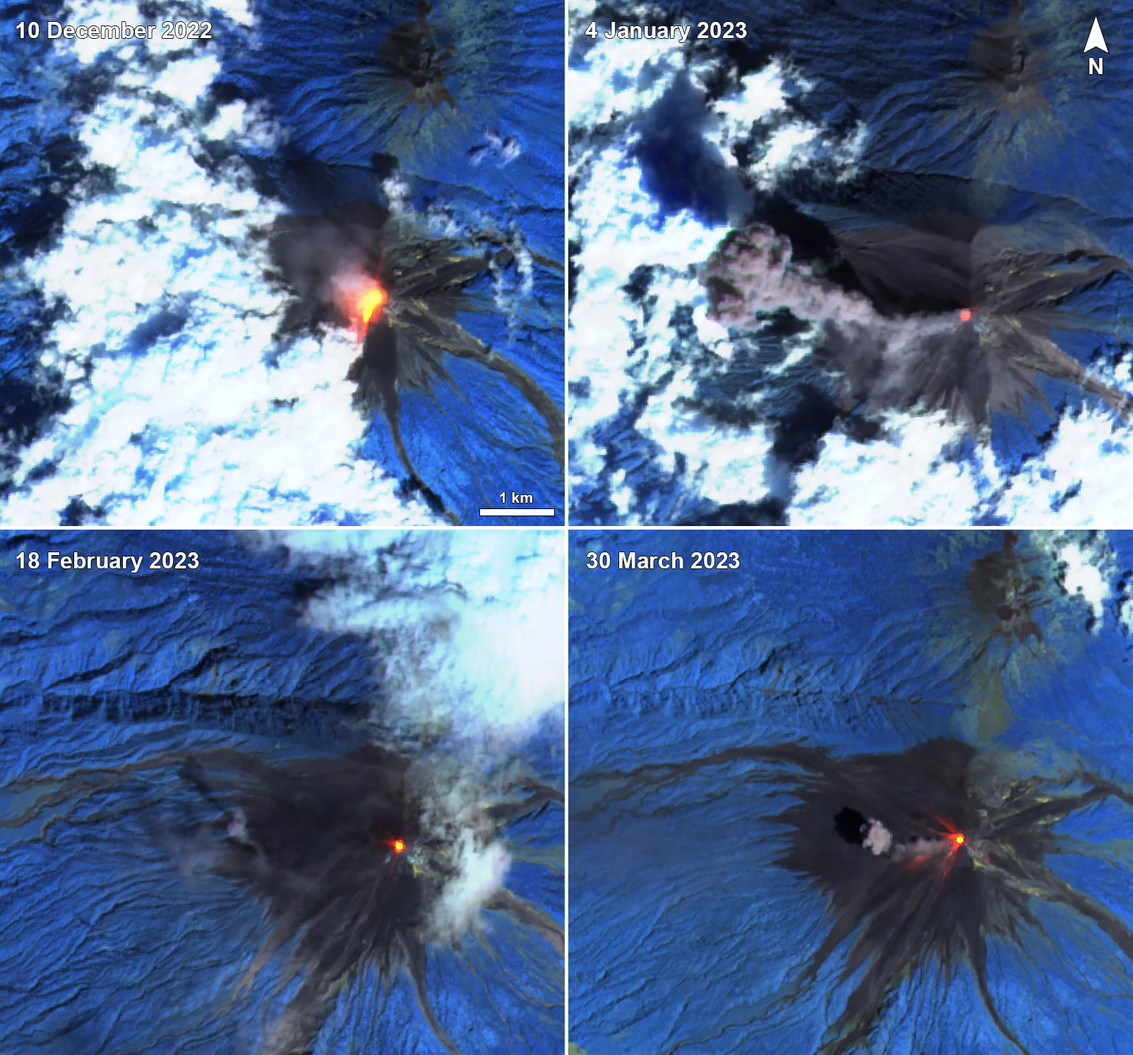 |
Figure 167. Frequent incandescent block avalanches descended multiple drainages at Fuego during December 2022 through March 2023, as shown in these Sentinel-2 infrared satellite images on 10 December 2022 (top left), 4 January 2023 (top right), 18 February 2023 (bottom left), and 30 March 2023 (bottom right). Gray ash plumes were also occasionally visible rising above the summit crater and drifting W, as seen on 4 January and 30 March. Avalanches affected the NW and S flanks on 10 December, the SW and W flanks on 18 February, and the NW, W, and SW flanks on 30 March. Images use Atmospheric penetration rendering (bands 12, 11, 8a). Courtesy of Sentinel Hub Playground. |
Daily explosions ranged between 1 and 12 per hour during December 2022, generating ash plumes that rose to 4.5-6 km altitude and drifted 10-30 km in multiple directions. These explosions created rumbling sounds with a shock wave that vibrated the roofs and windows of homes near the volcano. Frequent white gas-and-steam plumes rose to 4.6 km altitude. Strombolian activity resulted in incandescent pulses that generally rose 100-500 m above the crater, which generated weak-to-moderate avalanches around the crater and toward the Santa Teresa, Taniluyá, Ceniza, El Jute, Honda, Las Lajas, Seca, and Trinidad drainages, where material sometimes reached vegetation. Fine ashfall was recorded in Panimaché I and II (8 km SW), Morelia (9 km SW), Santa Sofía (12 km SW), El Porvenir (8 km ENE), Finca Palo Verde, Yepocapa (8 km NW), Yucales (12 km SW), Sangre de Cristo (8 km WSW), La Rochela, Ceilán, San Andrés Osuna, and Aldea La Cruz. INSIVUMEH reported that on 10 December a lava flow formed in the Ceniza drainage and measured 800 m long; it remained active at least through 12 December and block avalanches were reported at the front of the flow. A pyroclastic flow was reported at 1100 on 10 December, descending the Las Lajas drainage for several kilometers and reaching the base of the volcano. Pyroclastic flows were also observed in the Ceniza drainage for several kilometers, reaching the base of the volcano on 11 December. Ash plumes rose as high as 6 km altitude, according to a special bulletin from INSIVUMEH. On 31 December explosions produced incandescent pulses that rose 300 m above the crater, which covered the upper part of the cone.
Activity during January 2023 consisted of 1-12 daily explosions, which produced ash plumes that rose to 4.2-5 km altitude and drifted 7-60 km in multiple directions (figure 168). Incandescent pulses of material were observed 100-350 m above the crater, which generated avalanches around the crater and down the Ceniza, Las Lajas, Santa Teresa, Taniluyá, Trinidad, Seca, Honda, and El Jute drainages. Sometimes, the avalanches resuspended older fine material 100-500 m above the surface that drifted W and SW. Ashfall was recorded in Panimaché I and II, Morelia, Santa Sofía, El Porvenir, Palo Verde, Yucales, Yepocapa, Sangre de Cristo, La Rochela, Ceylon, Alotenango, and San Andrés Osuna. Intermittent white gas-and-steam plumes rose to 4.5 km altitude and drifted W and NW.
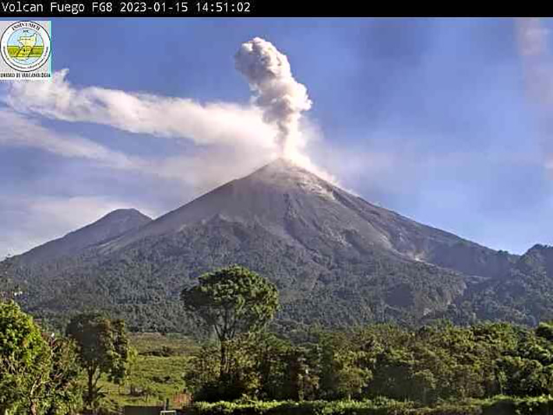 |
Figure 168. Webcam image showing an ash plume rising above Fuego on 15 January 2023. Courtesy of INSIVUMEH. |
There were 1-12 daily explosions recorded through February, which generated ash plumes that rose to 4.2-4.9 km altitude and drifted 10-30 km SW, W, NW, and N. Intermittent white gas-and-steam emissions rose 4.5 km altitude and drifted W and SW. During the nights and early mornings, incandescent pulses were observed 100-400 m above the crater. Weak-to-moderate avalanches were also observed down the Santa Teresa, Taniluyá, Ceniza, Las Lajas, Seca, Trinidad, El Jute, and Honda drainages, sometimes reaching the edge of vegetated areas. Occasional ashfall was reported in Panimaché I and II, Morelia, Santa Sofía, Palo Verde, San Pedro Yepocapa, El Porvenir, Sangre de Cristo, La Soledad, Acatenango, El Campamento, and La Asunción. On 18 February strong winds resuspended previous ash deposits as high as 1 km above the surface that blew 12 km SW and S.
During March, daily explosions ranged from 3-11 per hour, producing ash plumes that rose to 4-5 km altitude and drifted 10-30 km W, SW, NW, NE, N, S, SE, and E. During the night and early morning, crater incandescence (figure 169) and incandescent pulses of material were observed 50-400 m above the crater. Weak-to-moderate avalanches affected the Seca, Ceniza, Taniluyá, Las Lajas, Honda, Trinidad, El Jute, and Santa Teresa drainages, sometimes reaching the edge of vegetation. Frequent ashfall was detected in Yepocapa, Sangre de Cristo, Panimaché I and II, Morelia, Santa Sofía, El Porvenir, La Asunción, Palo Verde, La Rochela, San Andrés Osuna, Ceilán, and Aldeas. Weak ashfall was recorded in San Andrés Osuna, La Rochela, Ceylon during 8-9 March. A lahar was reported in the Ceniza drainage on 15 March, carrying fine, hot volcanic material, tree branches, trunks, and blocks from 30 cm to 1.5 m in diameter. On 18 March lahars were observed in the Las Lajas and El Jute drainages, carrying fine volcanic material, tree branches and trunks, and blocks from 30 cm to 1.5 m in diameter. As a result, there was also damage to the road infrastructure between El Rodeo and El Zapote.
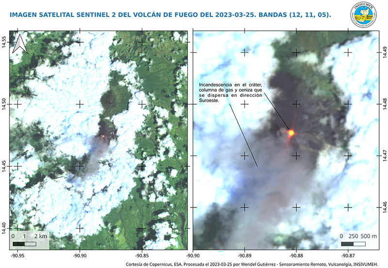 |
Figure 169. Sentinel-2 infrared satellite image showing Fuego’s crater incandescence accompanied by a gas-and-ash plume that drifted SW on 25 March 2023. Images use bands 12, 11, 5. Courtesy of INSIVUMEH. |
Geological Summary. Volcán Fuego, one of Central America's most active volcanoes, is also one of three large stratovolcanoes overlooking Guatemala's former capital, Antigua. The scarp of an older edifice, Meseta, lies between Fuego and Acatenango to the north. Construction of Meseta dates back to about 230,000 years and continued until the late Pleistocene or early Holocene. Collapse of Meseta may have produced the massive Escuintla debris-avalanche deposit, which extends about 50 km onto the Pacific coastal plain. Growth of the modern Fuego volcano followed, continuing the southward migration of volcanism that began at the mostly andesitic Acatenango. Eruptions at Fuego have become more mafic with time, and most historical activity has produced basaltic rocks. Frequent vigorous historical eruptions have been recorded since the onset of the Spanish era in 1524, and have produced major ashfalls, along with occasional pyroclastic flows and lava flows.
Information Contacts: Instituto Nacional de Sismologia, Vulcanologia, Meteorologia e Hydrologia (INSIVUMEH), Unit of Volcanology, Geologic Department of Investigation and Services, 7a Av. 14-57, Zona 13, Guatemala City, Guatemala (URL: http://www.insivumeh.gob.gt/ ); MIROVA (Middle InfraRed Observation of Volcanic Activity), a collaborative project between the Universities of Turin and Florence (Italy) supported by the Centre for Volcanic Risk of the Italian Civil Protection Department (URL: http://www.mirovaweb.it/); Hawai'i Institute of Geophysics and Planetology (HIGP) - MODVOLC Thermal Alerts System, School of Ocean and Earth Science and Technology (SOEST), Univ. of Hawai'i, 2525 Correa Road, Honolulu, HI 96822, USA (URL: http://modis.higp.hawaii.edu/); Sentinel Hub Playground (URL: https://www.sentinel-hub.com/explore/sentinel-playground).