Report on Nyamulagira (DR Congo) — May 2023

Bulletin of the Global Volcanism Network, vol. 48, no. 5 (May 2023)
Managing Editor: Edward Venzke.
Research and preparation by Paul Berger.
Nyamulagira (DR Congo) Summit crater lava flows and thermal anomalies continue, September 2022-April 2023
Please cite this report as:
Global Volcanism Program, 2023. Report on Nyamulagira (DR Congo) (Venzke, E., ed.). Bulletin of the Global Volcanism Network, 48:5. Smithsonian Institution.
Nyamulagira
DR Congo
1.408°S, 29.2°E; summit elev. 3058 m
All times are local (unless otherwise noted)
Nyamulagira is a shield volcano in the Democratic Republic of the Congo that hosts a lava lake in the large summit crater and contains numerous flank fissures and cinder cones. Recent activity has been characterized by lava effusion, thermal anomalies, seismicity, and gas-and-steam emissions (BGVN 45:12). The current report covers ongoing activity during September 2022-April 2023 based on satellite data.
Although there were some short periods without thermal anomalies detected, active lava flows and a lava lake in the summit crater were persistent on an almost daily basis through April 2023. The MIROVA (Middle InfraRed Observation of Volcanic Activity) system recorded numerous hotspots every month (figure 93) with intensities mostly in the moderate to high range, and a few in the very high range. Throughout the reporting period, hotspots were visible in every Sentinel-2 infrared image during the infrequent days when cloud conditions allowed observations (figure 94). Imagery during September-December 2022 showed multiple areas of lava effusion and flows within the caldera. Activity waned during January and February, with images showing a single clearly visible hotspot.
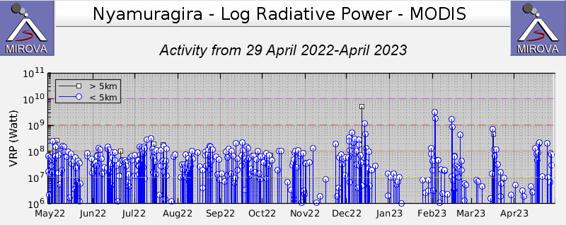 |
Figure 93. Frequent thermal anomalies at Nyamulagira shown on this MIROVA graph (Log Radiative Power) for the year ending 29 April 2023 were mostly of moderate to high intensity. Courtesy of MIROVA. |
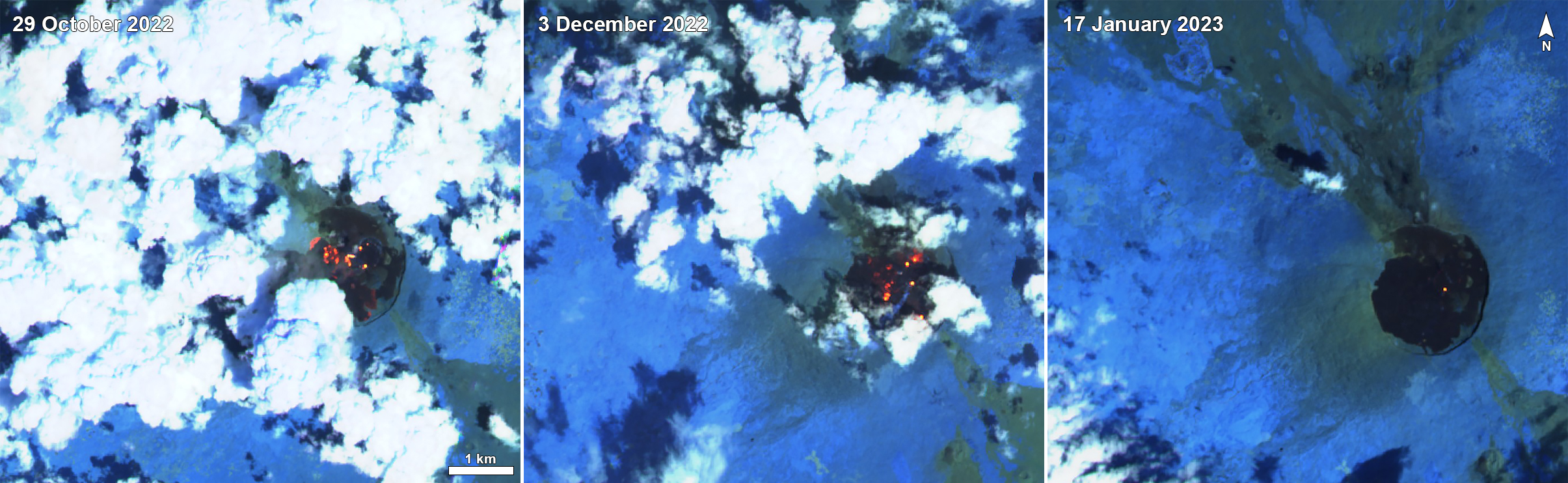 |
Figure 94. Examples of Sentinel-2 satellite images of Nyamulagira showing thermal anomalies consistent with open lava activity across much of the summit crater on 29 October and 3 December 2022, and only a small pit crater on 17 January 2023. Images rendered in “atmospheric penetration” (bands 12, 11, 8A). Courtesy of Sentinel Hub Playground. |
Geological Summary. Africa's most active volcano, Nyamulagira (also known as Nyamuragira), is a massive high-potassium basaltic shield about 25 km N of Lake Kivu and 13 km NNW of the steep-sided Nyiragongo volcano. The summit is truncated by a small 2 x 2.3 km caldera that has walls up to about 100 m high. Documented eruptions have occurred within the summit caldera, as well as from the numerous flank fissures and cinder cones. A lava lake in the summit crater, active since at least 1921, drained in 1938, at the time of a major flank eruption. Recent lava flows extend down the flanks more than 30 km from the summit as far as Lake Kivu; extensive lava flows from this volcano have covered 1,500 km2 of the western branch of the East African Rift.
Information Contacts: Observatoire Volcanologique de Goma (OVG), Departement de Geophysique, Centre de Recherche en Sciences Naturelles, Lwiro, D.S. Bukavu, DR Congo; MIROVA (Middle InfraRed Observation of Volcanic Activity), a collaborative project between the Universities of Turin and Florence (Italy) supported by the Centre for Volcanic Risk of the Italian Civil Protection Department (URL: http://www.mirovaweb.it/); Sentinel Hub Playground (URL: https://www.sentinel-hub.com/explore/sentinel-playground).