Report on Ulawun (Papua New Guinea) — August 2023
Bulletin of the Global Volcanism Network, vol. 48, no. 8 (August 2023)
Managing Editor: Edward Venzke.
Research and preparation by Paul Berger.
Ulawun (Papua New Guinea) Short explosion on 28 March with minor ashfall on nearby villages; renewed activity in mid-July 2023
Please cite this report as:
Global Volcanism Program, 2023. Report on Ulawun (Papua New Guinea) (Venzke, E., ed.). Bulletin of the Global Volcanism Network, 48:8. Smithsonian Institution.
Ulawun
Papua New Guinea
5.05°S, 151.33°E; summit elev. 2334 m
All times are local (unless otherwise noted)
Ulawun is a basaltic-to-andesitic stratovolcano on the island of New Britain, Papua New Guinea, that has been erupting since at least 1700. There have been frequent relatively short eruptions since 2012, with activity including explosions with ash plumes rising as high as 19 km (or 17 km above the summit), lava fountaining and flows, incandescence, brief thermal anomalies, sulfur dioxide emissions, gas-and-steam emissions, and increased seismicity (BGVN 44:09, 44:12). This report covers activity from July 2022 through July 2023 and is based on information from the Rabaul Volcano Observatory (RVO), the Darwin Volcanic Ash Advisory Centre (VAAC), and satellite data.
Thermal anomalies within the summit crater were detected in Sentinel-2 imagery on 19 July, 13 August, 23 August, 2 September, and 12 October 2022, but RVO reported no visible activity through that period. Anomalies were often absent during other days with clear views through July 2023. A single-day eruption took place on 28 March 2023 and then the start a new eruption period began in mid-July 2023.
Activity during March 2023. RVO reported a short explosion during 0408-0425 on 28 March, based on seismic data. A local volcano observer reported minor ashfall in areas to the NW including Ubili village, and the Ulamona Mission, Saltamana, and Ibana Village Oil Palm areas. According to the Darwin VAAC, at 0600 an ash plume was visible in a satellite image drifting W at an altitude of 3.4 km; the plume had dissipated by 1000. Thereafter, seismicity decreased, although weak high-frequency volcanic earthquakes were recorded, and tremor continued through 31 March. Steam plumes of variable densities rose above the summit. Prior to this explosion, small sulfur dioxide plumes were identified during 14-23 March.
Activity during July 2023. Low levels of seismicity were reported by RVO during 1-16 July, consisting of small, discrete, low-frequency earthquakes and occasional small high-frequency volcano-tectonic earthquakes. Late on 16 July RSAM values increased from 50 up to 500, climbing at a slow, erratic rate to 610 through 0500 on 18 July. During 0500-0700 the values dropped to 400-500, though peaks as high as 1,600 were recorded, but by 0700 values had decreased to 300 and remained steady. Minor ash emissions began on 18 June and during the morning of 19 July brown-to-gray emissions with low ash content were rising a few hundred meters about the crater rim and drifting SE.
During 20-25 July steam-and-gas plumes containing up to moderate amounts of ash rose from the summit crater and caused minor ashfall downwind in various directions, but mainly NW. Occasional ash emissions during 25-26 July drifted SE. Sulfur dioxide emissions were detected in satellite images on 21 and 24 July. Moderate seismicity was variable and was dominated by volcanic tremors. RSAM values between 22 and 25 July ranged between 380 and 800. The Alert Level was raised to Stage 2 (the second highest on the four-level scale).
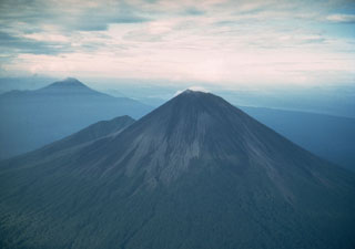
Geological Summary. The symmetrical basaltic-to-andesitic Ulawun stratovolcano is the highest volcano of the Bismarck arc, and one of Papua New Guinea's most frequently active. The volcano, also known as the Father, rises above the N coast of the island of New Britain across a low saddle NE of Bamus volcano, the South Son. The upper 1,000 m is unvegetated. A prominent E-W escarpment on the south may be the result of large-scale slumping. Satellitic cones occupy the NW and E flanks. A steep-walled valley cuts the NW side, and a flank lava-flow complex lies to the south of this valley. Historical eruptions date back to the beginning of the 18th century. Twentieth-century eruptions were mildly explosive until 1967, but after 1970 several larger eruptions produced lava flows and basaltic pyroclastic flows, greatly modifying the summit crater.
Information Contacts: Rabaul Volcano Observatory (RVO), Geohazards Management Division, Department of Mineral Policy and Geohazards Management (DMPGM), PO Box 3386, Kokopo, East New Britain Province, Papua New Guinea; Darwin Volcanic Ash Advisory Centre (VAAC), Bureau of Meteorology, Northern Territory Regional Office, PO Box 40050, Casuarina, NT 0811, Australia (URL: http://www.bom.gov.au/info/vaac/); Global Sulfur Dioxide Monitoring Page, Atmospheric Chemistry and Dynamics Laboratory, NASA Goddard Space Flight Center (NASA/GSFC), 8800 Greenbelt Road, Goddard, Maryland, USA (URL: https://SO2.gsfc.nasa.gov/); Sentinel Hub Playground(URL: https://www.sentinel-hub.com/explore/sentinel-playground).

