Report on Kavachi (Solomon Islands) — August 1976
Natural Science Event Bulletin, vol. 1, no. 11 (August 1976)
Managing Editor: David Squires.
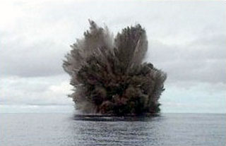
Kavachi (Solomon Islands) Pilot observes eruption of water and tephra above the surface on 23 August
Please cite this report as:
Global Volcanism Program, 1976. Report on Kavachi (Solomon Islands) (Squires, D., ed.). Natural Science Event Bulletin, 1:11. Smithsonian Institution. https://doi.org/10.5479/si.GVP.NSEB197608-255060
Kavachi
Solomon Islands
8.991°S, 157.979°E; summit elev. -20 m
All times are local (unless otherwise noted)
A new eruption of Kavachi volcano was sighted on 24 August at 0800 by Solair pilot Bruce Kirkwood. A fountain of water and volcanic ejecta reached 30 m height. The eruption was continuing as of 2 September. Seismicity was being monitored by Deni Tuni at Vakambo, 45 km north of the volcano. The last eruption of Kavachi ended in February 1970.
Geological Summary. Named for a sea-god of the Gatokae and Vangunu peoples, Kavachi is located in the Solomon Islands south of Vangunu Island. Sometimes referred to as Rejo te Kvachi ("Kavachi's Oven"), this shallow submarine basaltic-to-andesitic volcano has produced ephemeral islands up to 1 km long many times since its first recorded eruption during 1939. Residents of the nearby islands of Vanguna and Nggatokae (Gatokae) reported "fire on the water" prior to 1939, a possible reference to earlier eruptions. The roughly conical edifice rises from water depths of 1.1-1.2 km on the north and greater depths to the SE. Frequent shallow submarine and occasional subaerial eruptions produce phreatomagmatic explosions that eject steam, ash, and incandescent bombs. On a number of occasions lava flows were observed on the ephemeral islands.
Information Contacts: R. Thompson, Geological Survey, Honiara.