Report on Matthew Island (France - claimed by Vanuatu) — January 1977
Natural Science Event Bulletin, vol. 2, no. 1 (January 1977)
Managing Editor: David Squires.
Matthew Island (France - claimed by Vanuatu) Additional details from 27 November observation flight
Please cite this report as:
Global Volcanism Program, 1977. Report on Matthew Island (France - claimed by Vanuatu) (Squires, D., ed.). Natural Science Event Bulletin, 2:1. Smithsonian Institution. https://doi.org/10.5479/si.GVP.NSEB197701-258010
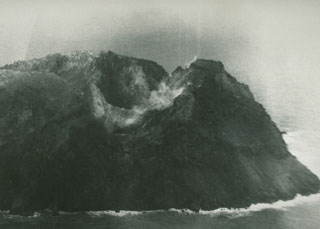
Matthew Island
France - claimed by Vanuatu
22.33°S, 171.32°E; summit elev. 177 m
All times are local (unless otherwise noted)
The following is additional information obtained by the RNZAF from the crew of the aircraft that flew over Matthew Island on 27 November.
During the overflight, the volcano emitted a gray dust cloud that merged with a layer of stratus clouds (held to about 350 m altitude by a temperature inversion). A strong sulfur odor was present in the area. Muddy gray discolored water was carried SE by the current. Because of poor weather and light conditions, no photographs were taken. More recent information on the activity is not available.
Geological Summary. Matthew Island is composed of two low andesitic-to-dacitic cones separated by a narrow isthmus. The Matthew name originates from an English mariner who sighted the island in 1788. Only the triangular eastern portion of the 0.6 x 1.2 km island was present prior to the 1940s, when construction of the larger western segment began; it consists primarily of lava flows. The western cone contains a crater that is breached to the NW and is filled by a lava flow whose terminus forms the NW coast.
Information Contacts: Defense Scientific Establishment, Auckland; J. Barnes, N.Z. Defense Staff, Washington DC.