Report on Langila (Papua New Guinea) — May 1978

Scientific Event Alert Network Bulletin, vol. 3, no. 5 (May 1978)
Managing Editor: David Squires.
Langila (Papua New Guinea) New mild Strombolian eruption
Please cite this report as:
Global Volcanism Program, 1978. Report on Langila (Papua New Guinea) (Squires, D., ed.). Scientific Event Alert Network Bulletin, 3:5. Smithsonian Institution. https://doi.org/10.5479/si.GVP.SEAN197805-252010
Langila
Papua New Guinea
5.525°S, 148.42°E; summit elev. 1330 m
All times are local (unless otherwise noted)
"Last year's mild Strombolian eruption at Crater 2 [NE crater] (figure 1 and 2) ended in mid-December, after a peak in early September during which a small amount of lava rose into the crater without overflowing. A new inner crater was blown through this lava a few weeks later and seems to have become considerably enlarged between aerial inspections on 21 March and 18 May. An unusually thick column of white vapor has been issuing from this crater during the last few weeks and a number of explosions were reported during May. A new mild Strombolian eruption [but see 3:9] from Crater 2 began 27-28 May and is continuing."
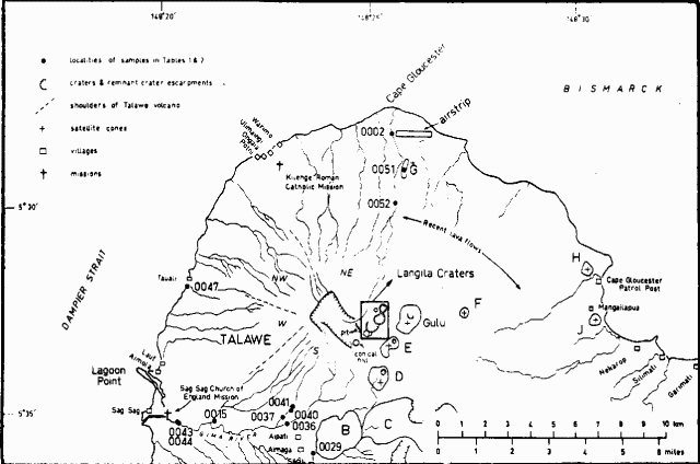 |
Figure 1. Sketch map of the NW tip of New Britain Island, showing Langila volcano and surrounding features. The portion of Langila's summit outlined by a box is shown in detail in figure 2. After Johnson and others (1971). |
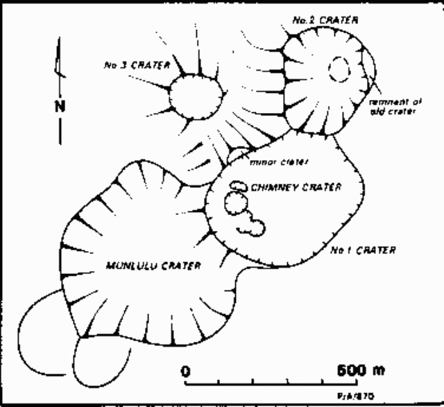 |
Figure 2. Summit area of Langila in 1970; the area shown is outlined in figure 1. From Palfreyman and others (1981). |
Further References. Johnson, R.W., Davies, R.A., and Palfreyman, W.D., 1971, Cape Glouster Area, New Britain: volcanic geology, petrology, and eruptive history of Langila craters through 1970: Australian Bureau of Mineral Resources, Geology and Geophysics, Record no. 1971/14, 34 p.
Palfreyman, W.D., Wallace, D.A., and Cooke, R.J.S., 1981, Langila volcano: summary of reported eruptive history, and eruption periodicity from 1961 to 1972, in Johnson, R.W. (ed.), Cooke-Ravian Volume of Volcanological Papers; Geological Survey of Papua New Guinea Memoir 10, p. 125-133.
Geological Summary. Langila, one of the most active volcanoes of New Britain, consists of a group of four small overlapping composite basaltic-andesitic cones on the lower E flank of the extinct Talawe volcano in the Cape Gloucester area of NW New Britain. A rectangular, 2.5-km-long crater is breached widely to the SE; Langila was constructed NE of the breached crater of Talawe. An extensive lava field reaches the coast on the N and NE sides of Langila. Frequent mild-to-moderate explosive eruptions, sometimes accompanied by lava flows, have been recorded since the 19th century from three active craters at the summit. The youngest and smallest crater (no. 3 crater) was formed in 1960 and has a diameter of 150 m.
Information Contacts: R. Cooke, RVO.