Report on Nyamulagira (DR Congo) — March 1980

Scientific Event Alert Network Bulletin, vol. 5, no. 3 (March 1980)
Managing Editor: David Squires.
Nyamulagira (DR Congo) Large lava flows and new cone on N flank
Please cite this report as:
Global Volcanism Program, 1980. Report on Nyamulagira (DR Congo) (Squires, D., ed.). Scientific Event Alert Network Bulletin, 5:3. Smithsonian Institution. https://doi.org/10.5479/si.GVP.SEAN198003-223020
Nyamulagira
DR Congo
1.408°S, 29.2°E; summit elev. 3058 m
All times are local (unless otherwise noted)
The Lwiro seismological station, 95 km S of Nyamuragira, recorded the onset of volcanic explosions at 1330 on 30 January. A new fissure, trending N20°E, opened on the N flank of the volcano. During the first week of activity, lava was extruded from 150 m of the fissure, with fountain heights exceeding 100 m. Beginning 6 February, the zone of fountaining along the fissure was reduced in length and a new cone (named Gasenyi) began to form 3 km N of the summit at 2,400-2,500 m above sea level and adjacent to an older cone (figure 2).
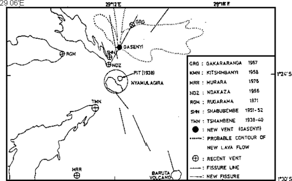 |
Figure 2. Map of Nyamuragira and vicinity showing approximate outlines of major lava flows from the new 1977 cone. Courtesy of N. Zana. |
Lava initially flowed NE, covering an area 2 km long and 0.5 km wide, with a maximum thickness of about 1 m. The second (main) flow moved more than 7 km, then turned in a northeasterly direction, over the 1958 Kitsimbanyi Flow, destroying a 13 km-long section of forest in Rwindi National Park. This flow reached a maximum width of 2.5 km, and was less than 0.5 m thick at its front. Three temporary seismic stations installed by the Geophysical Department of IRS began to record long-period microseisms at 1200 on 10 February.The next day at 1623, a new vent opened at the S end of the new cone, extruding a third lava flow that traveled over 7.5 km in a N70°E direction. This flow was about 1.5 m thick near the vent.
Explosions from the two vents were vigorous and often very noisy. Occasionally, both vents were active simultaneously, but explosions usually alternated between them, building a double cone with estimated dimensions of 100 m height and 200-300 m width by 17 February.
Katia Krafft flew over the eruption on 18 February. Fountains rose about 100 m from the two vents, which were within an active lava lake contained by the double cone. Extrusion of the small lava flows continued. Similar activity was continuing when she reached the volcano on the ground late 20 February. Red glow from the lava moving to the N was visible that night. Fountaining continued 21 February and aa lava was extruded slowly from the base of the N vent. More vigorous fountaining began that evening and a third vent was occasionally active. Lava was ejected to 120 m above the S vent. Discontinuous explosions occurred from the N vent, which overflowed during the night.
Microseismic activity recorded by IRS seismic stations declined sharply on 22 February. By 0300 on 23 February, lava extrusion had stopped and only a few feeble explosions were occurring from the vents. Only weak gas emission was observed the next day. Katia Krafft reports that both aa and pahoehoe flows were observed, and the lavas contained xenoliths of melted granite, pumice and porcellanite, as in most flank eruptions of Nyamuragira.
Further Reference. Brousse, R., Caron, J.P., Kampunzu, A.B., and others, 1981, Eruption et nature de la lave du Gasenyi: un nouveau volcan (Janvier-Fevrier 1980) au Flanc Nord du Nyamulagira (Kivu, Zaire): C.R. Acad. Sci. Paris, serie II, v. 292, p. 1413-1416.
Geological Summary. Africa's most active volcano, Nyamulagira (also known as Nyamuragira), is a massive high-potassium basaltic shield about 25 km N of Lake Kivu and 13 km NNW of the steep-sided Nyiragongo volcano. The summit is truncated by a small 2 x 2.3 km caldera that has walls up to about 100 m high. Documented eruptions have occurred within the summit caldera, as well as from the numerous flank fissures and cinder cones. A lava lake in the summit crater, active since at least 1921, drained in 1938, at the time of a major flank eruption. Recent lava flows extend down the flanks more than 30 km from the summit as far as Lake Kivu; extensive lava flows from this volcano have covered 1,500 km2 of the western branch of the East African Rift.
Information Contacts: N. Zana, IRS; K. Krafft, Cernay; Y. Pottier, Univ. Paris-Sud.