Report on Gamalama (Indonesia) — August 1980
Scientific Event Alert Network Bulletin, vol. 5, no. 8 (August 1980)
Managing Editor: David Squires.
Gamalama (Indonesia) Strong tephra eruption; 40,000 evacuate
Please cite this report as:
Global Volcanism Program, 1980. Report on Gamalama (Indonesia) (Squires, D., ed.). Scientific Event Alert Network Bulletin, 5:8. Smithsonian Institution. https://doi.org/10.5479/si.GVP.SEAN198008-268060
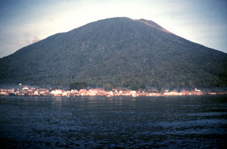
Gamalama
Indonesia
0.81°N, 127.3322°E; summit elev. 1714 m
All times are local (unless otherwise noted)
An incandescent tephra eruption from the central crater began with an explosion on 4 September at 1430, followed by a second ~ 2 hours later, and others at 0030, 0330, and 1120 the next day. Incandescent material fell 500-750 m from the crater, starting brush and forest fires. Ash fell on the entire island, accumulating to a depth of 10 cm by the second day of the eruption at Ternate City, 7-8 km E of the crater. Ash thicknesses reached 15 cm on some parts of the island, according to AFP.
Two earthquakes were felt by persons remaining on the island on 6 September as the eruption continued. By 7 September, activity had declined. Ash clouds rose ~ 1 km and were blown N by the prevailing wind, keeping ash away from the S half of the island, including Ternate City.
About 40,000 of the approximately 60,000 residents fled Ternate Island for Tidore Island, 5 km to the S, during the first two days of the eruption. No casualties have occurred according to the VSI, AFP, and Reuters, although some of the broadcast press apparently incorrectly reported casualties. A hazard map previously prepared by VSI delineates a danger zone of 33 km2 (population 2,500) in the summit area and an alert zone of 30 km2 on the N, NW, and NE flanks (population 2,500). The S and E parts of the island are considered to be safe by VSI.
Geological Summary. Gamalama is a near-conical stratovolcano that comprises the entire island of Ternate off the western coast of Halmahera, and is one of Indonesia's most active volcanoes. The island was a major regional center in the Portuguese and Dutch spice trade for several centuries, which contributed to the extensive documentation of activity. Three cones, progressively younger to the north, form the summit. Several maars and vents define a rift zone, parallel to the Halmahera island arc, that cuts the volcano; the S-flank Ngade maar formed after about 14,500–13,000 cal. BP (Faral et al., 2022). Eruptions, recorded frequently since the 16th century, typically originated from the summit craters, although flank eruptions have occurred in 1763, 1770, 1775, and 1962-63.
Information Contacts: A. Sudradjat, VSI; AFP; Reuters.