Report on Piton de la Fournaise (France) — January 1981

Scientific Event Alert Network Bulletin, vol. 6, no. 1 (January 1981)
Managing Editor: Lindsay McClelland.
Piton de la Fournaise (France) Fissure eruption follows inflation and seismicity
Please cite this report as:
Global Volcanism Program, 1981. Report on Piton de la Fournaise (France) (McClelland, L., ed.). Scientific Event Alert Network Bulletin, 6:1. Smithsonian Institution. https://doi.org/10.5479/si.GVP.SEAN198101-233020
Piton de la Fournaise
France
21.244°S, 55.708°E; summit elev. 2632 m
All times are local (unless otherwise noted)
A summit area eruption began on 3 February after 12 days of local earthquakes and 17 cm of summit inflation. After a fairly sudden onset of seismicity 23 January, about forty M 2 events were recorded daily by the newly established Observatoire Volcanologique du Piton de la Fournaise. The day before the start of the eruption, 73 earthquakes were recorded, with foci ~1 km beneath Cratère Bory, the smaller of the two summit craters. Seismicity intensified in the hour prior to the first eruptive activity on 3 February. About 250 small discrete events were followed by 5 minutes of harmonic tremor. At 2030 a small fissure opened in Cratère Bory. A minor lava flow was extruded during 2 hours of activity along this fissure and a 6-m-high hornito formed at the vent. During the second hour of the eruption, a small amount of aa lava flowed from a vent 200 m below the rim separating the larger Cratère Dolomieu from Bory. This lava covered about 3/4 of a small crater ruin (Enclos Velain) between Bory and Dolomieu. After about 2 hours, two or three small fissures opened on the NE side of Cratère Dolomieu, each extruding a lava flow 100 m long.
The next morning at about 0400, a 300-m-long N-S-trending fissure formed lower on the NE side of Dolomieu. Three spatter vents were active initially, but within an hour fountaining (15-30 m high) was limited to the lower portion of the fissure. Lava flowed downslope through channels and tubes onto the caldera floor.
As of early 6 February, lava fountaining as much as 70 m high was continuing from a 30-m-long segment of the lower end of the fissure. The activity had built a small, elongated cone with three vents. The lava flow, composed of aphyric basalt, was 1.5-2 km in length and covered several thousand square meters of the caldera floor (figure 6). Seismicity beneath Cratère Bory had stopped a few hours after the eruption began, but small events were occurring 6 February beneath Nez Coupé de Ste. Rose, on the caldera's N rim.
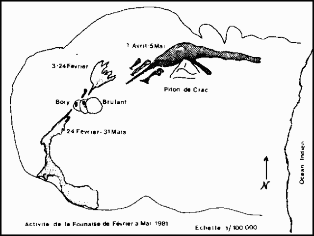 |
Figure 6. Map showing the eruption fissures and lava flows from the three phases of the 3 February-5 May 1981 eruption of Piton de la Fournaise. Map prepared by F.X. Lalanne, Observatoire Volcanologique de la Réunion. |
This eruption produced more lava than the two most recent eruptions, 28-29 May and 13-14 July 1979. However, the 1981 volume is of the same order of magnitude as has been extruded in most of its numerous lava flow eruptions from the summit area in the past 50 years.
Geological Summary. Piton de la Fournaise is a massive basaltic shield volcano on the French island of Réunion in the western Indian Ocean. Much of its more than 530,000-year history overlapped with eruptions of the deeply dissected Piton des Neiges shield volcano to the NW. Three scarps formed at about 250,000, 65,000, and less than 5,000 years ago by progressive eastward slumping, leaving caldera-sized embayments open to the E and SE. Numerous pyroclastic cones are present on the floor of the scarps and their outer flanks. Most recorded eruptions have originated from the summit and flanks of Dolomieu, a 400-m-high lava shield that has grown within the youngest scarp, which is about 9 km wide and about 13 km from the western wall to the ocean on the E side. More than 150 eruptions, most of which have produced fluid basaltic lava flows, have occurred since the 17th century. Only six eruptions, in 1708, 1774, 1776, 1800, 1977, and 1986, have originated from fissures outside the scarps.
Information Contacts: L. Stieltjes, BRGM, Réunion; Volcano Observatory of Réunion; M. Krafft, Cernay.